US Topo. The Next Generation of Topographic Maps. U.S. Department of the Interior U.S. Geological Survey
|
|
|
- Maximillian Hood
- 5 years ago
- Views:
Transcription

1 US Topo The Next Generation of Topographic Maps U.S. Department of the Interior U.S. Geological Survey


2 Foundation: The National Map Base topographic data Seamless Continuously maintained Nationally consistent Developed and maintained through partnerships Available on line Source for products and services 2


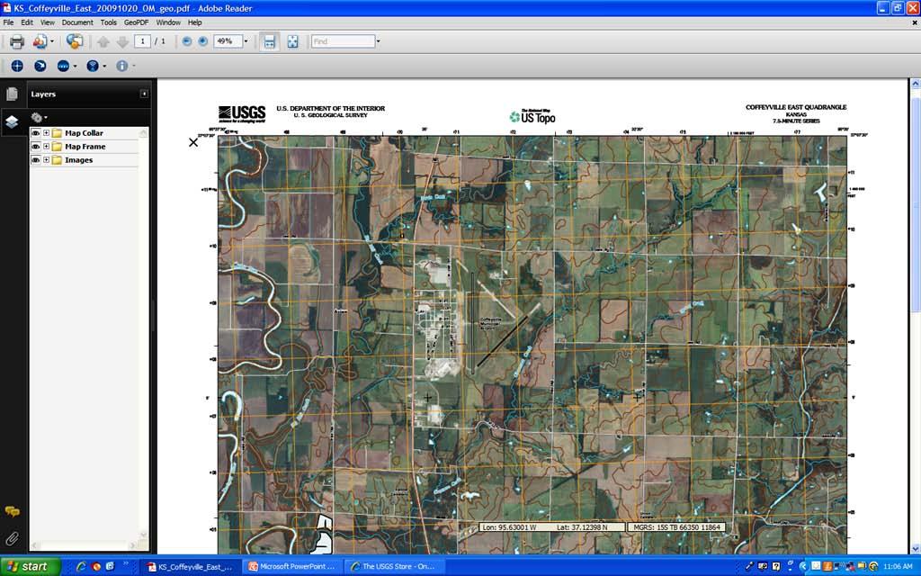
3 US Topo A new USGS topographic map product Digital GeoPDF Format Available free on the Web Image base Core feature layers Built from The National Map data Periodic update 3


4 Digital Map Beta Initial version of US Topo Launched in June 2009 More than 14,100 produced Content limited to image base, roads, and names Will be revised to include contours and hydrographic features (US Topo)


5 Strategy US Topo Content Orthorectified image Roads Names Contours Hydrography 5
6 Strategy (continued) Evolution Data layers added as they become available in The National Map Features added as technical processes are perfected Full topographic quadrangle map content (ultimately) Bundled with scanned historical quadrangle maps Three-year revision cycle Linked to US Department of Agriculture s National Agricultural Imagery Program (NAIP) image acquisition schedule 6

7
8 Product Characteristics GeoPDF format A TerraGo Technologies published extension to the Adobe PDF file format File size about Mb Georeferenced Locations defined in terms of map projection or coordinate systems Layered (select layers, turn layers on/off) Limited interactive capabilities, free tools 8
9 Key Advantages Accessible on line from a personal computer Interactive & enhanced Functionally superior to a Digital Raster Graphic (DRG) Will evolve & improve over time Plot / print ready Authoritative content Quality assured to standards Public domain Free download 9

10 10
11 Scanned Historical Topographic Maps FY 2010 goals: Create high-quality scans of all printed USGS topographic maps (all scales and vintages) for archive and public access Bundle scanned historical topographic map(s) with corresponding US Topos Make scanned maps available for free download through the USGS Store 11


12 Map time series An historical perspective of the Nation s landscape change
 http://hdds.usgs.")
13 Emergency Responder Access Hazards Data Distribution System (HDDS) (Password Protected) 13

14 Hazards Data Distribution System This page offers US Topo and Digital Maps Beta Another page offers image maps made in USGS is putting all US Topo products on HDDS Available for pre- or post-event download 14

15 Public Access USGS Store Select Map Locator Yellow rectangles show available Digital Maps Beta Red rectangles show available US Topos Status shown as of April 23,

16 Public Access (continued) Select a quadrangle for list of available maps US Topos and GeoPDFs - free download Hard copy - $15.00 (today) 16
17 System Requirements Windows operating system Windows 7, XP, Server 2003, or Vista Broadband Internet access Highly recommended Adobe Reader software Free download on Internet Will also work with Adobe Acrobat ($$) Latest three versions of either are acceptable TerraGo Technologies Toolbar Not required, but recommended for enhanced functions Free download 17
 Interactive GeoPDF map Access to FGDC metadata Georeferenced cursor coordinates")
18 Downloaded Map Adobe Reader with GeoPDF Tools Adobe Acrobat and Terrago Technologies tools Layers list (compressed) Interactive GeoPDF map Access to FGDC metadata Georeferenced cursor coordinates 18

19 Downloaded Map Layer List (expanded) 19

20 Metadata Access 20


21 Metadata Reader 21

22 GeoPDF Toolbar Geo Tool Google Map-It Tool 22

23 GeoPDF Toolbar Geo Tool Google Map-It Tool 23


24 Coordinate System Change Reference system coordinates Coordinates for X or follow cursor Change coordinate system for readout of cursor s position 24


25 GeoPDF Toolbar Linear Measure & Measurement Units Preferences 25

26 GeoPDF Toolbar Area Measure US or Metric units 26


27 GeoPDF Toolbar GeoTrack Displays geo position. Requires attached GPS unit. 27


28 Printing/Plotting Print/plot part or all of the map 28


29 Text Searching Step 2 Results Step 1 29


30 Web Site Home Page 30

31 Map Store - Download 31

32 Map Store - Download 32


33 Web Site - Frequently Asked Questions 33


34 Web Site - Draft Standard 34

35 Web Site - Quickstart Users Guide 35


36 Web Site - Information Sheet 36

37 Web Site - Feedback Form 37
38 Chris Cretini U.S. Geological Survey NSDI Partnership Office
Tricks and Tips of Creating a Layered, Geo-Enabled Adobe PDF Map
 Tricks and Tips of Creating a Layered, Geo-Enabled Adobe PDF Map John M. Bocan GIS Programmer/Analyst West Virginia Geological and Economic Survey (WVGES) Digital Mapping Techniques Williamsburg, VA. May
MAGIP 2009 Technical Session. presented by Michael Sweet College of Forestry and Conservation The University of Montana
 presented by Michael Sweet College of Forestry and Conservation The University of Montana GeoPDFs Provide a standard format for use and exchange of GIS documents with non-gis users Custom coordinate displays(up
590 Nutrient Application Restriction Maps: An Overview and Demonstration. Sara Walling DATCP
 590 Nutrient Application Restriction Maps: An Overview and Demonstration Sara Walling DATCP 608-224-4524 sara.walling@wisconsin.gov 590 GeoPDFs 590 Spreading Restriction Maps Online Statewide, county,
You can measure distances and the area within a boundary and then convert those measurements to GeoMarks.
 TerraGo Mobile Version 1.0.1, April 2013 The 1.0.1 release of TerraGo Mobile was developed in accordance with the requirements and release schedule. What is TerraGo Mobile? What s new in this release?
Activity: Exploring GeoPDFs
 Activity: Exploring GeoPDFs A GeoPDF is a map stored in Adobe s Portable Document Format that is geographically referenced to a real world coordinate system. TerraGo Technologies, which is the company
State Health Programs. Medi-Cal. Health Net s. Provider Library. Quick access to the information you need
 Health Net s Provider Library Quick access to the information you need State Health Programs Medi-Cal Navigating the Provider Library The Provider Library houses archives of provider communications previously
I. An Intro to ArcMap Version 9.3 and 10. 1) Arc Map is basically a build your own Google map
 Arc Map is basically a build your own Google map") I. An Intro to ArcMap Version 9.3 and 10 What is Arc Map? 1) Arc Map is basically a build your own Google map a. Display and manage geo-spatial data (maps, images, points that have a geographic location)
I. An Intro to ArcMap Version 9.3 and 10 What is Arc Map? 1) Arc Map is basically a build your own Google map a. Display and manage geo-spatial data (maps, images, points that have a geographic location)
AVID Reports. General
 AVID Reports General Table of Contents Overview... 3 Technical Requirements... 3 Gaining Access... 4 Forgotten Password...4 Forgotten Login ID...5 Password Changes...5 Navigation... 6 Reports Menu...6
IndianaMap Release 3. Rick Hill, Paul Rohwer,, Chris Dintaman, Becky Meyer, and Denver Harper
 IndianaMap Release 3 Rick Hill, Paul Rohwer,, Chris Dintaman, Becky Meyer, and Denver Harper IndianaMap Agenda Session 1 & 2 Overview Tentative rollout schedule Old versus New Design and construction of
IHS Standards Expert FAQs
 IHS Standards Expert FAQs New IHS Standards Expert FAQs based on Customer First surveys How can I find out what is part of my subscription? How do I know what I have access to? There are two easy ways
QA Hub User Guide. IM11 V001 dated
 QA Hub User Guide 1 QA HUB USER GUIDE What is the Quality Assurance (QA) Hub? The QA Hub is a web-based data management tool, which has replaced Elmhurst s original Monitoring system. The QA Hub will maintain
Interactive Maps Purpose: Login to the System: Interactive Maps ONTINUE AGREE
 Interactive Maps Purpose: The purpose of this application is to provide the facility to the citizen to navigate to a Property through an On-line Free Web Application in real time. The application uses
National Register of Historic Places: GIS Webinar Cultural Resource GIS Facility National Park Service June 2012
 National Register of Historic Places: GIS Webinar Cultural Resource GIS Facility National Park Service June 2012 National Register Draft Electronic Map Policy Factsheet Required: WGS/NAD datum A map that
Valeo WebEDI OBP 3.3 Training document. General overview and User Administration. WebEDI: Thomas Gries. Page 1
 Valeo WebEDI OBP 3.3 Training document General overview and User Administration WebEDI: Thomas Gries Page 1 Table of content Table of content...2 1 Valeo WebEDI based on Odette e-forms 2 recommendation...3
Chapter 3: Maps as Numbers
 Chapter 3: Maps as Numbers 3. Representing Maps as Numbers 3.2 Structuring Attributes 3.3 Structuring Maps 3.4 Why Topology Matters 3.5 Formats for GIS Data 3.6 Exchanging Data David Tenenbaum EEOS 265
SkylineGlobe 6.5 s New Developments
 SkylineGlobe 6.5 s New Developments The SkylineGlobe Enterprise suite of applications was created to provide all of the necessary software tools for an organization to implement their own private, 3D virtual
Earthmate PN-60w GPS Details Key Features:
 Earthmate PN-60w GPS Details Key Features: Earthmate PN-60w with SPOT Satellite Communicator» 3.5 GB of internal flash memory» Intuitive icon-based user interface for easy on-device navigation» Elevation
UAV s in Surveying: Integration/processes/deliverables A-Z. 3Dsurvey.si
 UAV s in Surveying: Integration/processes/deliverables A-Z Info@eGPS.net TODAY S PROGRAM Introduction to photogrammetry and 3Dsurvey Theoretical facts about the technology and basics of 3dsurvey Introduction
Georeferencing Topo Sheets and Scanned Maps
 Georeferencing Topo Sheets and Scanned Maps QGIS Tutorials and Tips Author Ujaval Gandhi http://www.spatialthoughts.com This work is licensed under a Creative Commons Attribution 4.0 International License.
Xerox 700 Digital Color Press with Integrated Fiery Color Server. Welcome
 Xerox 700 Digital Color Press with Integrated Fiery Color Server Welcome 2008 Electronics for Imaging, Inc. The information in this publication is covered under Legal Notices for this product. 45072712
Next Generation Geodata
 Rapid Mapping Next Generation Geodata NAME DATE OCCASION/VENUE Anders Modén, STS Nov 19, 2009 SESAM-09 Introduction Geological data is used everywhere Industrial Usage Construction, City Planning, Traffic,
OPERATIONS IMAGE SERVICE. Alyssa Geyer & Erin Ukestad April 21, 2016
 OPERATIONS IMAGE SERVICE Alyssa Geyer & Erin Ukestad April 21, 2016 Purpose To explore the challenges and successes of the effort that the Tobin Data division of P2 Energy Solutions has undertaken to migrate
LiDAR Derived Contours
 LiDAR Derived Contours Final Delivery June 10, 2009 Prepared for: Prepared by: Metro 600 NE Grand Avenue Portland, OR 97232 Watershed Sciences, Inc. 529 SW Third Avenue, Suite 300 Portland, OR 97204 Metro
ADOBE ACROBAT PRO DC: PDF CONVERTER, CONVERT PDFS FROM (ARCHIVES) ADOBE ACROBAT 9 PRO: USING SEARCH AND REDACT
 ADOBE ACROBAT 9 PRO: USING SEARCH AND REDACT") ADOBE ACROBAT 9 PRO PDF ADOBE ACROBAT PRO DC: PDF CONVERTER, CONVERT PDFS FROM (ARCHIVES) ADOBE ACROBAT 9 PRO: USING SEARCH AND REDACT 1 / 5 2 / 5 3 / 5 adobe acrobat 9 pro pdf Adobe Acrobat Pro DC makes
ADOBE ACROBAT 9 PRO PDF ADOBE ACROBAT PRO DC: PDF CONVERTER, CONVERT PDFS FROM (ARCHIVES) ADOBE ACROBAT 9 PRO: USING SEARCH AND REDACT 1 / 5 2 / 5 3 / 5 adobe acrobat 9 pro pdf Adobe Acrobat Pro DC makes
MDT Images inserts in the current CAD drawing one or several orthophotos with most common formats (see requirements) at their real coordinates.
 at their real coordinates.") TCP MDT Digital Terrain Model - V 6.5 Images Module This module is specially designed for projects in which frequently work with aerial photographies, orthophotos and scanned maps in combination with vectorial
TCP MDT Digital Terrain Model - V 6.5 Images Module This module is specially designed for projects in which frequently work with aerial photographies, orthophotos and scanned maps in combination with vectorial
An Introduction to Lidar & Forestry May 2013
 An Introduction to Lidar & Forestry May 2013 Introduction to Lidar & Forestry Lidar technology Derivatives from point clouds Applied to forestry Publish & Share Futures Lidar Light Detection And Ranging
Best Practices for Managing Scanned Imagery. Peter Becker
 Best Practices for Managing Scanned Imagery Peter Becker Objectives Making Scanned Imagery Accessible - Topographic maps - Historic scanned maps - Navigation maps - Engineering drawings Uses of Scanned
Click on a link below to navigate this document, or use bookmarks in Adobe.
 Website Instructions Click on a link below to navigate this document, or use bookmarks in Adobe. Logging in and User Registration MyUSG Quoting Online with Westchester, A Chubb Company Quoting Online with
Livingston County MAP User Guide
 Livingston County MAP User Guide Need help with the Livingston County MAP? Click the button located on each tool s window to view the help documentation for that specific tool. If you need additional information
OFFICE OF STATE FIRE MARSHAL HAZARDOUS MATERIALS INFORMATION REQUEST --INFORMATION AVAILABLE--
 OFFICE OF STATE FIRE MARSHAL HAZARDOUS MATERIALS INFORMATION REQUEST --INFORMATION AVAILABLE-- The information available through the Office of State Fire Marshal, Community Right to Know unit (OSFM, CR2K),
National Highway Specifications Website
 National Highway Specifications Website Past, Present, and Future presented by Linda Konrath for AASHTO SCoC Annual Meeting August 1, 2007 Background AASHTO Resolution 99-0 Objective: One-Stop source for
Working with PDF Maps
 Working with PDF Maps Right of Way Mapping and Monitoring LIS & R/W Mapping Unit 1 P age Contents General Navigation... 3 Page Navigation tools... 3 Page display... 4 Zoom... 5 Rotate View... 6 Summary
OnCOR Silverlight Viewer Guide
 Getting Around There are many ways to move around the map! The simplest option is to use your mouse in the map area. If you hold the left button down, then click and drag, you can pan the map to a new
Automatic Extraction of Road Intersection Position, Connectivity and Orientations from Raster Maps
 Automatic Extraction of Road Intersection Position, Connectivity and Orientations from Raster Maps Yao-Yi Chiang and Craig Knoblock University of Southern California epartment of Computer Science and Information
Terrain and Imagery Tutorial. Contents. By: Brian Zager
 Terrain and Imagery Tutorial By: Brian Zager http://www.zagerdesign.com/golf_design/ This tutorial provides and overview on how terrain data and overhead imagery are used to create real courses or courses
Topic 1: Getting started Topic 2: Finding a location... 5
 Navigating LISTmap Topic 1: Getting started... 3 1. What is LISTmap?... 3 2. Compatible browsers... 3 3. A quick look at LISTmap... 3 Topic 2: Finding a location... 5 1. Using the search bar... 5 2. Zooming...
2009 Electronics for Imaging, Inc. The information in this publication is covered under Legal Notices for this product.
 GA-1310 Welcome 2009 Electronics for Imaging, Inc. The information in this publication is covered under Legal Notices for this product. 45085373 5 May 2009 WELCOME 3 WELCOME This Welcome document provides
DIRECTORY OF FOREST PRODUCTS INDUSTRIES APPLICATION USER GUIDE
 DIRECTORY OF FOREST PRODUCTS INDUSTRIES APPLICATION USER GUIDE Directory of Forest Products Industries Table of Contents 1 ABOUT THE DIRECTORY OF FOREST PRODUCTS INDUSTRIES... 4 1.1 ACCESSING THE DIRECTORY.
Files Used in this Tutorial
 RPC Orthorectification Tutorial In this tutorial, you will use ground control points (GCPs), an orthorectified reference image, and a digital elevation model (DEM) to orthorectify an OrbView-3 scene that
Heads up Digitizing v 9.3
 Heads up Digitizing v 9.3 Created by Vince DiNoto Vince.dinoto@kctcs.edu Table of Contents Prerequisite... 2 Getting Started... 2 ArcCatalog ArcMap Projection... 4 Attribute Table... 6 Editor... 7 Table
Files Used in this Tutorial
 RPC Orthorectification Tutorial In this tutorial, you will use ground control points (GCPs), an orthorectified reference image, and a digital elevation model (DEM) to orthorectify an OrbView-3 scene that
M c i r c os o t S at a io i n o n an a d n d A lll lth T i h n i g n s g s P D P F Agenda
 MicroStation and All Things PDF Agenda Basic PDF Creation from within MicroStation PDF Printer Drivers Printing 3D Design Geometry to a PDF File Sending Geospatial Data to a PDF Exporting Business Data
1. Introduction... Page User administration... Page View your sites.. Page View your PDF reports. Page 7
 Contents 1. Introduction...... Page 3 2. User administration........ Page 4 3. View your sites.. Page 6 4. View your PDF reports. Page 7 5. View your action plan Page 7 6. View action details.. Page 9
International D&I Programs SUMMER OLYMPICS SECURITY PACKAGE
 PPRROOM MOO International D&I Programs SUMMER OLYMPICS SECURITY PACKAGE BARRA OLYMPIC PARK CONSTRUCTION RIO DE JANEIRO PROMO OLYMPIC SECURITY PACKAGE 2016 Olympic security package Since the 2009 announcement
Revision History. Last saved by: Leanne Mowat. Last save time: 1/25/2019 3:39 PM. Revision Date Author Description
 Revision History Last saved by: Leanne Mowat Last save time: 1/25/2019 3:39 PM Revision Date Author Description 0.1 2018-12-18 Leanne Mowat Initial version 0.2 2019-01-11 Leanne Mowat Updated the Register
Overview. Finding information and help Adobe Acrobat. Where to find it and why to use it. When converting from Word to Acrobat
 Formatting 101: Adobe Acrobat October 2017 Overview 2 Finding information and help Adobe Acrobat Where to find it and why to use it How to embed fonts When converting from Word to Acrobat Using the grid
The U.S. National Spatial Data Infrastructure
 June 18, 2014 INSPIRE Conference 2014 The U.S. National Spatial Data Infrastructure past present and future Ivan B. DeLoatch Executive Director, Federal Geographic Data Committee U.S. Geological Survey
PDF Filer Manual Revised 4/7/2007
 PDF Filer Manual Revised 4/7/2007 edocfile, Inc. 2709 Willow Oaks Drive Valrico, FL 33594 Phone 813-413-5599 sales@edocfile.com www.edocfile.com Table of Contents Table of Contents --------------------------------------------------------------------------------------------
6 Best Practices for Sharing
 The Definitive Guide TO Sharing GIS Maps 6 Best Practices for Sharing Interactive Maps with Anyone, Anywhere Let s get started From paper to PDF, from GIS to the cloud, the ability to share maps with people
TotalFlow Prep, Print Manager & Production Manager. The tools that will redefine your entire print production
 TotalFlow Prep, Print Manager & Production Manager The tools that will redefine your entire print production Giving your business a clear advantage TotalFlow. Productivity. Performance. Opportunity Ricoh
SLR, Climate Change, Infrastructure Solutions, Adaption and GIS
 Presenters: Francisco D Elia B.S., M.Sc. Geographic Information Systems Franciscodelia@miamibeachfl.gov Nestor Navarro, GISP, MCSA GIS Manager Nestornavarro@miamibeachfl.gov Data Acquisition, Integration
DOWNLOAD OR READ : WHO WAS WHO IN ORTHODONTICS WITH A SELECTED BIBLIOGRAPHY OF ORTHODONTIC HISTORY 1ST BOOKS LIBRARY PDF EBOOK EPUB MOBI
 DOWNLOAD OR READ : WHO WAS WHO IN ORTHODONTICS WITH A SELECTED BIBLIOGRAPHY OF ORTHODONTIC HISTORY 1ST BOOKS LIBRARY PDF EBOOK EPUB MOBI Page 1 Page 2 books library who was who in pdf books library pdf995
Internet Video Security Monitoring Systems QUICK START GUIDE SEE WHAT YOU VE BEEN MISSING
 Internet Video Security Monitoring Systems QUICK START GUIDE SEE WHAT YOU VE BEEN MISSING Under the copyright laws, this documentation may not be copied, photocopied, reproduced, translated, or reduced
UAS Campus Survey Project
 ARTICLE STUDENTS CAPTURING SPATIAL INFORMATION NEEDS UAS Campus Survey Project Texas A&M University- Corpus Christi, home to the largest geomatics undergraduate programme in Texas, USA, is currently undergoing
Schedule 3 Background 3 What is ArchSite? 3 Introduction 3 ArchSite Viewer Options 4 Disclaimers 5 Creating a User Account 5 Working with the Public
 Introduction to ArchSite TABLE OF CONTENTS Schedule 3 Background 3 What is ArchSite? 3 Introduction 3 ArchSite Viewer Options 4 Disclaimers 5 Creating a User Account 5 Working with the Public View 6 Public
Acrobat 6.0 Standard - Basic Tasks
 Converting Office Documents to PDF 1. Create and edit document in Office application (Word, Excel, PowerPoint) 2. Click the Convert to PDF button on the Acrobat toolbar If the buttons are not visible,
USER S GUIDE Software/Hardware Module: ADOBE ACROBAT 7
 University of Arizona Information Commons Training 1 USER S GUIDE Software/Hardware Module: ADOBE ACROBAT 7 Objective: Scan and create PDF Documents using Adobe Acrobat Software p.1 Introduction p.2 Scanning
Using All Topo Maps to Bring in a Background Quad Map in Pathfinder Office or ArcView
 Using All Topo Maps to Bring in a Background Quad Map in Pathfinder Office or ArcView Pathfinder Office, ArcView, and ArcExplorer can all display background image files, such as Digital Raster Graphics
FOREST MANAGEMENT PLANNING APPLICATION USER GUIDE
 FOREST MANAGEMENT PLANNING APPLICATION USER GUIDE Forest Management Planning Table of Contents 1 ABOUT FOREST MANAGEMENT PLANNING 4 1.1 ACCESSING FOREST MANAGEMENT PLANNING 4 2 USING FOREST MANAGEMENT
BuildersCAD 8.3 New Features
 BuildersCAD 8.3 New Features Plotting PDF Plotting The plot functions for PDF have been moved to their own menu You can access it from a button at the lower right of the regular plot menu: Or from the
An Overview of Mobile GIS Apps for Field Data Collection. Matt Alexander Anatum Field Solutions, LLC
 An Overview of Mobile GIS Apps for Field Data Collection Matt Alexander Anatum Field Solutions, LLC 2010 ios GIS Apps No accurate GPS/GNSS (TestedniPhone 6 and ipad Air = 6.5m [95% CI]) New Tech Opens
1. NJDEP Landscape 3.3 Viewer Interface
 Using the Landscape Project through NJDEP Landscape 3.3 Viewer Google Chrome or Mozilla Firefox are recommended for the use of this app. Navigate to the NJDEP-DFW s Landscape Project web page at www.njfishandwildlife.com/ensp/landscape/
Table 1. Minimum Web Console Requirements. Browser Microsoftt Internet Explorer 9.0, 10.0, 11.0 (32 and 64 bit)
") System s Parent topic: Preparation Web Console Table 1. Minimum Web Console s Browser Microsoftt Internet Explorer 9.0, 10.0, 11.0 (32 and 64 bit) Mozilla Firefox 52.5.0 (ESR), 56.0.2, 57.0.1, 58.0 Google
System s Parent topic: Preparation Web Console Table 1. Minimum Web Console s Browser Microsoftt Internet Explorer 9.0, 10.0, 11.0 (32 and 64 bit) Mozilla Firefox 52.5.0 (ESR), 56.0.2, 57.0.1, 58.0 Google
Help Guide Rev
 Help Guide Rev. 1.0 07152014 Home Page The home page displays your vehicle(s) on a satellite map. The information box, showing vehicle information will already be opened. The information box displays your
who is on the pdf pdf 995: create PDF documents easily for free PDFescape - Free PDF Editor & Free PDF Form Filler
 DOWNLOAD OR READ : WHO IS ON THE LORDS SIDE A QUESTION OF AUTHORITY IN MATTERS OF FAITH WHO MUST DEFINE DOCTRINES FOR THE SEVENTH DAY ADVENTIST MOVEMENT WHAT KIND OF HAS IT PDF EBOOK EPUB MOBI Page 1 Page
Web Based Training (WBT) Design for Online Master Acrobat Pages Tutorial
 Design for Online Master Acrobat Pages Tutorial") Beverly Morris August 2, 2010 PTC-650 Web Based Training (WBT) Design for Online Master Acrobat Pages Tutorial Section 1 - WBT Design Document Section 2 - Course Flow Chart Section 3 - Course Story Board
Beverly Morris August 2, 2010 PTC-650 Web Based Training (WBT) Design for Online Master Acrobat Pages Tutorial Section 1 - WBT Design Document Section 2 - Course Flow Chart Section 3 - Course Story Board
FAQ & Troubleshooting
 FAQ & Troubleshooting What is the most common issue users have when using the site? Pop-Up Blocker!!! Any link external to the viewer requires a new window to be opened in the browser. See My map or report
LocateXT Version 1.3 Quick Start
 LocateXT Version 1.3 Quick Start NOTE: Portions of this guide show capabilities not available in certain versions of the LocateXT software product System Requirements Operating System, 32-bit or 64-bit
OziExplorer Training and Help Manual for Use with Soil Resource Stewardship Monitoring Checklist: Cutblock-Level
 OziExplorer Training and Help Manual for Use with Soil Resource Stewardship Monitoring Checklist: Cutblock-Level Stéphane Dubé, Soil Scientist MOFR Northern Interior Forest Region May 2009 Version 2 Starting
Adobe Acrobat 8 Professional - Available November 8, 2006 Communicate and Collaborate with the Essential PDF Solution
 Adobe Acrobat 8 Professional - Available November 8, 2006 Communicate and Collaborate with the Essential PDF Solution Acrobat 8 - Top 10 Reason to buy - NEW Acrobat Customer Ability to unlock advanced
Hank Garie Executive Director of GOS Keynote Speaker. National States Geographic Information Council Annual Meeting Nashville, TN
 Hank Garie Executive Director of GOS Keynote Speaker National States Geographic Information Council 2003 Annual Meeting Nashville, TN Compiled by Jim Steil, Mississippi State University *Disclaimer: Please
New Mexico s RGIS Program: State Geospatial Data Clearinghouse
 New Mexico s RGIS Program: State Geospatial Data Clearinghouse Laura Gleasner Su Zhang November 10, 2016 New Mexico RGIS: The State Digital Geospatial Data Clearinghouse The Resource Geographic Information
Geological mapping using open
 Geological mapping using open source QGIS MOHSEN ALSHAGHDARI -2017- Abstract Geological mapping is very important to display your field work in a map for geologist and others, many geologists face problems
CODEVINTEC. Caris Hydrographic Survey. CARIS HIPS and SIPS CARIS Onboard. Bathy DataBASE 4.4. Bathy DataBASE Server 4.3. BASE Editor 4.
 45 27 39.384 N 9 07 30.145 E Caris Hydrographic Survey Photo: João Ventura da Cruz CARIS HIPS and SIPS 10.4 page 2 CARIS Onboard page 4 Bathy DataBASE 4.4 page 6 Bathy DataBASE Server 4.3 page 7 BASE Editor
Remote Deposit Express User Guide
 Remote Deposit Express User Guide November 2013, v04 Table of Contents TABLE OF CONTENTS... 2 OVERVIEW... 3 BEST PRACTICES & DAILY PROCEDURES... 4 SERVICE STANDARDS... 7 RDE MINIMUM WORKSTATION REQUIREMENTS...
MYOB Enterprise Solutions software system requirements guidelines. Thursday, 6 May 2010 Version 2.0
 MYOB Enterprise Solutions software system Thursday, 6 May 2010 Version 2.0 Contents 1 System Requirements... 4 1.1 Overview... 4 1.2 Server requirements... 4 1.2.1 Server Requirements (excluding Terminal
Pennsylvania Mine Map Grant Project
 Pennsylvania Mine Map Grant Project NAAMLP 2014 Conference Patrick Jaquay, GISP PA Department of Environmental Protection Mine Map Grant Project Competitive Grant for Educational Institutions and Not-for-Profit
Manually Uninstall Adobe Reader X Full Version Offline Installer
 Manually Uninstall Adobe Reader X Full Version Offline Installer A guide on how to install Adobe Reader 9.5 to improve PDF viewing Adobe Reader X and newer versions have become somewhat bloated with features
Encoded URLs in hyperlinks. TerraGo Publisher for ArcGIS TerraGo Publisher for ArcGIS Server TerraGo Arc2Edge Version 7.3.
 TerraGo Publisher for ArcGIS TerraGo Publisher for ArcGIS Server TerraGo Arc2Edge Version 7.3.1, December 2017 What is TerraGo Publisher for ArcGIS? What is TerraGo Arc2Edge? What s new in this release?
Singapore. Mr Soh Kheng Peng. Singapore Land Authority
 Country Report 2006 (Based on the PCGIAP-Data Integration Template 2006) Singapore Country/state: Name of contact person: Affiliation, Organization: Function, Position: Address: Email address: Tel, Fax
Getting Started with the NH Stone Wall Mapper January 2019
 Getting Started with the NH Stone Wall Mapper January 2019 Stone walls are significant cultural and historical features of the New England landscape. Creating a statewide inventory of existing stone walls
Note: You must already be enrolled and issued with a Username and Password
 Diploma of Management and Diploma of International Business Student Login: Note: You must already be enrolled and issued with a Username and Password www.hs.edu Start here Select your course Enter Username
estatements Help Document October 2016
 estatements Help Document October 2016 Table of Contents Section 1 - Accessing estatements.... 2 Section 2 - Requirements..... 3 Section 3 - Viewing estatements. 3 Section 4 - Printing and Saving estatements
GIS Change Requests: Web Base change requests will replace MSAG Update paper form.
 GIS Change Requests: Web Base change requests will replace MSAG Update paper form. Types of edits that will need to be reported Individual address edits (move, delete, add or change) Road edits (add, delete,
QA Hub User Guide. IM11 V005 dated_
 QA Hub User Guide IM11 V005 dated_04.02.14 1 Contents 1 How does the QA Hub Work?... 3 2 How do I access the QA Hub?... 4 3 Overview Screen... 5 4 Submitting your evidence to us... 6 5 Upload Evidence...
expressreports Guide
 expressreports Guide i Table of Contents expressreports Guide TABLE OF CONTENTS Chapter Chapter 1. Chapter 2. Page INTRODUCTION...1 Internet Access to Reports...1 Documentation...2 ACCESSING YOUR REPORTS...4
First Scottish Online Ordering User Guide
 First Scottish Online Ordering User Guide 1.13 www.firstscottish.com TABLE OF CONTENTS Getting Started Page Introduction 3 Minimum system requirements 3 Support details 3 Password protection 3 Login name
Shoreline Change from a Storm Event Procedure using the Digital Shoreline Analysis System
 Shoreline Change from a Storm Event Procedure using the Digital Shoreline Analysis System Brian Madore November 18, 2014 The Digital Shoreline Analysis System (DSAS) is an ArcMap extension created by the
Technical Whitepaper. Unlock your Subsurface Data using Seismic Explorer for ArcGIS & the ArcGIS Platform
 Technical Whitepaper Unlock your Subsurface Data using Seismic Explorer for ArcGIS & the ArcGIS Platform 1 Business Problem The Petroleum industry and their vendors have for years been talking about the
Topcon Tools Processing RTK Data Application Guide
 P O S I T I O N I N G S Y S T E M S Topcon Tools Processing RTK Data Application Guide Part Number 7010-0928 Rev A Copyright Topcon Positioning Systems, Inc. April, 2009 All contents in this manual are
GSSHA WMS Basics Loading DEMs, Contour Options, Images, and Projection Systems
 v. 10.0 WMS 10.0 Tutorial GSSHA WMS Basics Loading DEMs, Contour Options, Images, and Projection Systems Learn how to work with DEMs and images and to convert between projection systems in the WMS interface
IMAGINE OrthoRadar. Accuracy Evaluation. age 1 of 9
 IMAGINE OrthoRadar Accuracy Evaluation age 1 of 9 IMAGINE OrthoRadar Product Description IMAGINE OrthoRadar is part of the IMAGINE Radar Mapping Suite and performs precision geocoding and orthorectification
Bringing NYSGA Guidebooks to Google Earth
 Bringing NYSGA Guidebooks to Google Earth Otto H. Muller Geology Department, Alfred University Alan I. Benimoff Executive Secretary, New York State Geological Association benimoff@mail.csi.cuny.edu William
3D Elevation Program- Status and Updates. Claire DeVaughan South Central Arc User Group Conference April 11, 2018
 + 1 3D Elevation Program- Status and Updates Claire DeVaughan South Central Arc User Group Conference April 11, 2018 + 2 3D Elevation Program (3DEP) Goals Complete acquisition in 8 years Address Federal,
Converting AutoCAD Map 2002 Projects to ArcGIS
 Introduction This document outlines the procedures necessary for converting an AutoCAD Map drawing containing topologies to ArcGIS version 9.x and higher. This includes the export of polygon and network
v Introduction to WMS WMS 11.0 Tutorial Become familiar with the WMS interface Prerequisite Tutorials None Required Components Data Map
 s v. 11.0 WMS 11.0 Tutorial Become familiar with the WMS interface Objectives Import files into WMS and change modules and display options to become familiar with the WMS interface. Prerequisite Tutorials
On the Road to 2020 Census Geographic Programs Update Oregon State Data Center Annual Meeting 11/29/2012
 On the Road to 2020 Census Geographic Programs Update Oregon State Data Center Annual Meeting 11/29/2012 Rick Campbell Geographer L.A. Regional Office (Based in Seattle) richard.t.campbell@census.gov (206)
Advanced PDF features
 1 of 7 2/17/2009 10:56 PM Show Navigation Hide Navigation You are here: Mapping and v isualization > Page layout and map composition > Map output Advanced PDF features Release 9.3 Last modified November
Best Practices for Managing Processed Ortho Imagery
 Best Practices for Managing Processed Ortho Imagery Cody Benkelman DRAFT slides (June 2017) Characteristics of Processed Ortho Imagery Typically 8 bit (sometimes 16) Typically 3 spectral bands (sometimes
Section 508 Assessment and Voluntary Product Accessibility Template (VPAT ) Development for VMware. VMware View 4.0 Report
 Development for VMware. VMware View 4.0 Report") Section 508 Assessment and Voluntary Product Accessibility Template (VPAT ) Development for VMware VMware View 4.0 Report December 18, 2009 SUBMITTED BY: Rockville Commerce Center Building A, Unit 1 2410
Section 508 Assessment and Voluntary Product Accessibility Template (VPAT ) Development for VMware VMware View 4.0 Report December 18, 2009 SUBMITTED BY: Rockville Commerce Center Building A, Unit 1 2410