Multisensoral UAV-Based Reference Measurements for Forestry Applications
|
|
|
- Marshall Curtis
- 5 years ago
- Views:
Transcription

1 Multisensoral UAV-Based Reference Measurements for Forestry Applications Research Manager D.Sc. Anttoni Jaakkola Centre of Excellence in Laser Scanning Research
2 2 Outline UAV applications Reference level UAS measurements Low-cost LiDAR High-end LiDAR Hyperspectral camera FMCW radar Multrispectral LiDAR Future outlook of UAV LiDAR
3 History 3


4 4 Strengths of UAS Measurements Small area mapping Corridor mapping Multitemporal measurements Air/spaceborne sensor Simulation Validation Reference data collection
5 Alternative Platforms 5


6 Mapping: Urban Planning 6
7 Corridors: Roads 7

8 Corridors: Power Lines 8
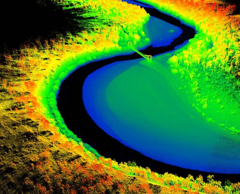
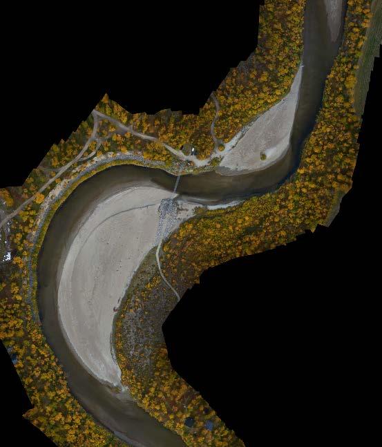
9 Corridors: Rivers 9
10 Multitemporal Data 10

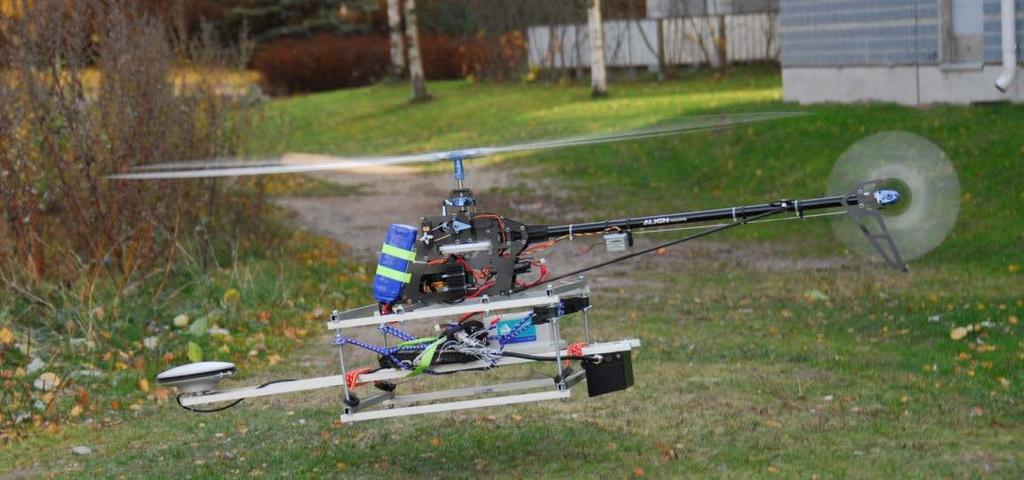
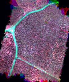
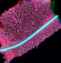
11 UAV-Based Reference Data Collection 11 Evo test site Southern Finland Boreal forest Pine Spruce Birch 91 test plots 32x32 m
12 Low-Cost LiDAR 12 Velodyne VLP-16 Lite Novatel SPAN-IGM S1 40 m AGL 10 m line spacing 8 m/s Up to 800 pts/m 2 Single plot
13 Low-Cost LiDAR 13 Velodyne Puck LITE Novatel IGM-S1 Size Ø103 x 72 mm Size 152 x 142 x 51 mm Weight 590 g Weight 540 g Measurement range 100 m Measurement rate 125 Hz Pulse repetition rate Hz Horizontal accuracy 1 cm Profile frequency 16 x 20 Hz Vertical accuracy 2 cm Range accuracy ±3 cm Roll/Pitch accuracy Beam divergence 3 mrad Heading accuracy 0.080

14 Low-Cost LiDAR 14
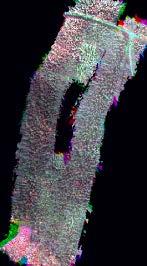
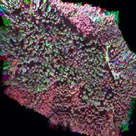
15 Low-Cost LiDAR 15 Bias Bias (%) RMSE RMSE (%) R Tree height (m) DBH (cm) Basal area (m 2 ) Volume (m 3 ) Biomass (Mg)

16 16 High-End LiDAR Riegl VQ-480-U Novatel SPAN-LCI 75 m AGL Single overpass >100 pts/m 2

17 17 High-End LiDAR Riegl VQ-480-U Size Weight Measurement range Pulse repetition rate Profile frequency Range accuracy Beam divergence Ø183 x 348 mm 7.5 kg m Hz 150 Hz ±2.5 cm 0.3 mrad

18 High-End LiDAR 18

19 High-End LiDAR 19
20 High-End LiDAR 20
21 21 High-End LiDAR Non-calibrated Calibrated Height DBH Basal area Volume Biomass Bias (%) RMSE (%) R

22 22 Hyperspectral Camera Fabry-Pérot interferometric hyperspectral camera RGB camera GNSS L1 receiver 90 m AGL 4 m/s

23 23 Hyperspectral Camera Rikola/Senop FPI camera nm 1010 x 1010 pixels Up to 30 fps Samsung NX300 APS-C, 24 mpix


24 Hyperspectral Mosaics 1 2 3,
25 Individual tree classification Reference data: - fieldwork data (location & species) Classification features 3D features of individual trees (RGB pointcloud) Lastools Classification Feature Selection Classification training and evaluation Weka Spectral features from hyperspectral FPI mosaics Matlab Classification of detected trees Photoscan Photogrammetric point cloud from RGB imagery FUSION Software (Pacific Northwest Research Station) ) Digital Surface Model (DSM) Digital terrain model (DTM) from NLS ALS data Canopy Height Model (CHM) = DSM DTM Individual tree detection using local maxima method
 Spectral Features (no norm. spectra) Feature Selection (no norm. spectra) 3D Features Accuracy (%) 95.11 94.")
26 Hyperspectral Camera 26 True Class Precision Pine Spruce Birch Larch Classified as Recall Pine Spruce Birch Larch All Features Spectral Features Feature Selection All Features (no norm. spectra) Spectral Features (no norm. spectra) Feature Selection (no norm. spectra) 3D Features Accuracy (%) Kappa
 Sweep frequency 1000 Mhz Range")

27 27 FMCW Radar Frequency 14.0 GHz (Ku) Sweep frequency 1000 Mhz Range resolution 15 cm Beam width 6 Polarization HH, VV, HV, VH Weight 14 kg (UAV version 6 kg) Single line, m AGL
28 FMCW Radar 28

29 FMCW Radar 29
 C")
30 30 FMCW Radar (a) B E db db A (b) C D

31 FMCW Radar 31
32 32 FMCW Radar mean height (m) mean DBH (cm) Observed 20 Observed Mean height (m) Mean DBH (cm) Basal area (m 2 /ha) Volume (m 3 /ha) Biomass (Mg/ha) Bias Bias (%) RMSE RMSE (%) R Observed Observed Predicted Predicted 50 2 basal area (m /ha) Predicted 250 biomass (Mg/ha) Observed /ha) volume (m Predicted Predicted

33 33 Multispectral LiDAR Optech Titan
34 34 Multispectral LiDAR Chan1 Chan2 Chan
35 35 Multispectral LiDAR Confusion matrix based on intensity features Reference Predicted Producer Pine Spruce Birch Pine Spruce Birch User Overall = 86.81%
36 36 Multispectral LiDAR Confusion matrix based on point cloud and intensity features Reference Predicted Producer Pine Spruce Birch Pine ,55 Spruce ,10 Birch ,43 User Overall = 88.36%
37 37 Future Outlook of LiDAR Technology Automotive industry Solid state / flash LiDAR technology Multispectral LiDAR Single photon LiDAR


38 38 Automotive Industry Driving the development of low-cost light-weight LiDARs Range accuracy or beam divergence are not the primary targets


39 39 Solid-State Technology Automotive applications require low cost and high reliability Optical beam steering


40 40 Flash LiDAR Low volume and high price of InGaAs components Frame based, but low resolution


41 41 Multispectral LiDAR Optech Titan or multiple scanners, e.g. Faro S120 + X330 Currently heavy and expensive


42 42 Single photon LiDAR Currently available for full-scale airborne laser scanning
43 43 Summary UAV-based measurements can be used as reference data for some applications Efficiency compared to manual measurements may be higher by an order of magnitude Current LiDAR sensors are still heavy, expensive, inaccurate and/or limited in measurement range Development towards new sensor technologies is rapid
Sensors and applications for drone based remote sensing
 Sensors and applications for drone based remote sensing Dr. Ilkka Pölönen Dr. Eija Honkavaara, NLS Dr. Heikki Saari, VTT Dr. Sakari Tuominen, Mr. Jere Kaivosoja, Luke Laboratory Joint research with Finnish
Using Lidar and ArcGIS to Predict Forest Inventory Variables
 Using Lidar and ArcGIS to Predict Forest Inventory Variables Dr. Kevin S. Lim kevin@limgeomatics.com P.O. Box 45089, 680 Eagleson Road Ottawa, Ontario, K2M 2G0, Canada Tel.: 613-686-5735 Fax: 613-822-5145
Lidar-based Transport Research
 Lidar-based Transport Research Juha Hyyppä Antero Kukko, Anttoni Jaakkola (Gaze Inc), Harri Kaartinen, Xiaowei Yu Paikkatietokeskus Hannu Hyyppä, Matti Vaaja, Aalto Centre of Excellence in Laser Scanning
LiForest Software White paper. TRGS, 3070 M St., Merced, 93610, Phone , LiForest
 0 LiForest LiForest is a platform to manipulate large LiDAR point clouds and extract useful information specifically for forest applications. It integrates a variety of advanced LiDAR processing algorithms
EnsoMOSAIC. Kopterit metsäninventointidatan keruualustoina
 EnsoMOSAIC Kopterit metsäninventointidatan keruualustoina 20.4.2017 Company introduction MosaicMill founded in 2009 EnsoMOSAIC technology since 1994 Main businesses EnsoMOSAIC forestry solutions EnsoMOSAIC
Lidar Sensors, Today & Tomorrow. Christian Sevcik RIEGL Laser Measurement Systems
 Lidar Sensors, Today & Tomorrow Christian Sevcik RIEGL Laser Measurement Systems o o o o Online Waveform technology Stand alone operation no field computer required Remote control through wireless network
Laser scanners with echo digitization for full waveform analysis
 Laser scanners with echo digitization for full waveform analysis Peter Rieger, Andreas Ullrich, Rainer Reichert RIEGL Laser Measurement Systems GmbH DI Peter Rieger Project Management RIEGL LMS GmbH A-3580
UAS based laser scanning for forest inventory and precision farming
 UAS based laser scanning for forest inventory and precision farming M. Pfennigbauer, U. Riegl, P. Rieger, P. Amon RIEGL Laser Measurement Systems GmbH, 3580 Horn, Austria Email: mpfennigbauer@riegl.com,
Backpack-based inertial navigation and LiDAR mapping in forest environments
 Backpack-based inertial navigation and LiDAR mapping in forest environments Mattias Tjernqvist June 2017 Introduction 3D model our environment Light Detection And Ranging (LiDAR) - Light - Laser scanner
MODELLING FOREST CANOPY USING AIRBORNE LIDAR DATA
 MODELLING FOREST CANOPY USING AIRBORNE LIDAR DATA Jihn-Fa JAN (Taiwan) Associate Professor, Department of Land Economics National Chengchi University 64, Sec. 2, Chih-Nan Road, Taipei 116, Taiwan Telephone:
Airborne Laser Scanning: Remote Sensing with LiDAR
 Airborne Laser Scanning: Remote Sensing with LiDAR ALS / LIDAR OUTLINE Laser remote sensing background Basic components of an ALS/LIDAR system Two distinct families of ALS systems Waveform Discrete Return
New possibilities of remote sensing, point clouds, laser scanning and UAV LS
 New possibilities of remote sensing, point clouds, laser scanning and UAV LS Juha Hyyppä Director, NLS/FGI, juha.hyyppa@nls.fi Director, CoE-LaSR Prof., NLS/FGI, Juha.Coelasr@gmail.com Content What is
LiDAR and its use for the enhanced forest inventory
 LiDAR and its use for the enhanced forest inventory Richard Fournier Département de géomatique appliquée Workshop of the Canadian Institute of Forestry Corner Brook, Newfoundland, March 27 2013 LiDAR -
Integration of airborne LiDAR and hyperspectral remote sensing data to support the Vegetation Resources Inventory and sustainable forest management
 Integration of airborne LiDAR and hyperspectral remote sensing data to support the Vegetation Resources Inventory and sustainable forest management Executive Summary This project has addressed a number
STUDIES OF PHASE CENTER AND EXTINCTION COEFFICIENT OF BOREAL FOREST USING X- AND L-BAND POLARIMETRIC INTERFEROMETRY COMBINED WITH LIDAR MEASUREMENTS
 STUDIES OF PHASE CENTER AND EXTINCTION COEFFICIENT OF BOREAL FOREST USING X- AND L-BAND POLARIMETRIC INTERFEROMETRY COMBINED WITH LIDAR MEASUREMENTS Jaan Praks, Martti Hallikainen, and Xiaowei Yu Department
An Introduction to Lidar & Forestry May 2013
 An Introduction to Lidar & Forestry May 2013 Introduction to Lidar & Forestry Lidar technology Derivatives from point clouds Applied to forestry Publish & Share Futures Lidar Light Detection And Ranging
Voxelised metrics for forest inventory. Grant Pearse Phenotype Cluster Group Meeting April 2018
 Voxelised metrics for forest inventory Grant Pearse Phenotype Cluster Group Meeting April 2018 Overview Voxelisation for forest inventory Background on LiDAR metric analysis Voxelisation what and why?
CLASSIFICATION OF NONPHOTOGRAPHIC REMOTE SENSORS
 CLASSIFICATION OF NONPHOTOGRAPHIC REMOTE SENSORS PASSIVE ACTIVE DIGITAL CAMERA THERMAL (e.g. TIMS) VIDEO CAMERA MULTI- SPECTRAL SCANNERS VISIBLE & NIR MICROWAVE HYPERSPECTRAL (e.g. AVIRIS) SLAR Real Aperture
Using Hyperspectral Frame Images from Unmanned Airborne Vehicle for Detailed Measurement of Boreal Forest 3D Structure
 IOP Conference Series: Earth and Environmental Science PAPER OPEN ACCESS Using Hyperspectral Frame Images from Unmanned Airborne Vehicle for Detailed Measurement of Boreal Forest 3D Structure Recent citations
ENY-C2005 Geoinformation in Environmental Modeling Lecture 4b: Laser scanning
 1 ENY-C2005 Geoinformation in Environmental Modeling Lecture 4b: Laser scanning Petri Rönnholm Aalto University 2 Learning objectives To recognize applications of laser scanning To understand principles
Mayden VP of Business Development Surdex Corporation
 Making Sense of Sensors Randy Mayden, Mayden VP of Business Development Surdex Corporation randym@surdex.com EARLYAERIAL PHOTOGRAPHY 2 FIRSTAERIAL CAMERA 3 AERIAL CAMERA SYSTEM DEVELOPMENT Aerial Camera
Hardware 3D Mapping Systems
 Hardware 3D Mapping Systems About Us GreenValley International GreenValley International provides 3D mapping solutions that include mobile & aerial LiDAR acquisition hardware, post-processing software
SPAR, ELMF 2013, Amsterdam. Laser Scanning on the UK Highways Agency Network. Hamish Grierson Blom Uk
 SPAR, ELMF 2013, Amsterdam Laser Scanning on the UK Highways Agency Network Hamish Grierson Blom Uk www.blomasa.com www.blom-uk.co.uk Blom UK Part of the Blom Group Blom Group - Europe s largest aerial
Airborne LiDAR Data Acquisition for Forestry Applications. Mischa Hey WSI (Corvallis, OR)
") Airborne LiDAR Data Acquisition for Forestry Applications Mischa Hey WSI (Corvallis, OR) WSI Services Corvallis, OR Airborne Mapping: Light Detection and Ranging (LiDAR) Thermal Infrared Imagery 4-Band
Airborne LiDAR Data Acquisition for Forestry Applications Mischa Hey WSI (Corvallis, OR) WSI Services Corvallis, OR Airborne Mapping: Light Detection and Ranging (LiDAR) Thermal Infrared Imagery 4-Band
Automotive LiDAR. General Motors R&D. Ariel Lipson
 Automotive LiDAR General Motors R&D Ariel Lipson Overview How LiDARs work (Automotive) State of play current devices, costs Alternative technologies / approaches and future outlook Advantages of LiDAR-enabled
Contents. State of the Art in Laser Scanning 9/20/2011
 Contents State of the Art in Laser Scanning Juha Hyyppä, Anttoni Jaakkola, Antero Kukko, Harri Kaartinen, Sanna Kaasalainen, Eetu Puttonen, Xiaowei Yu, Hannu Hyyppä*, Lingli Zhu, Matti Lehtomäki, Yi Lin,
Course Outline (1) #6 Data Acquisition for Built Environment. Fumio YAMAZAKI
 #6 Data Acquisition for Built Environment. Fumio YAMAZAKI") AT09.98 Applied GIS and Remote Sensing for Disaster Mitigation #6 Data Acquisition for Built Environment 9 October, 2002 Fumio YAMAZAKI yamazaki@ait.ac.th http://www.star.ait.ac.th/~yamazaki/ Course Outline
AT09.98 Applied GIS and Remote Sensing for Disaster Mitigation #6 Data Acquisition for Built Environment 9 October, 2002 Fumio YAMAZAKI yamazaki@ait.ac.th http://www.star.ait.ac.th/~yamazaki/ Course Outline
Forest Structure Estimation in the Canadian Boreal forest
 Forest Structure Estimation in the Canadian Boreal forest Michael L. Benson Leland E.Pierce Kathleen M. Bergen Kamal Sarabandi Kailai Zhang Caitlin E. Ryan The University of Michigan, Radiation Lab & School
IMPROVED TARGET DETECTION IN URBAN AREA USING COMBINED LIDAR AND APEX DATA
 IMPROVED TARGET DETECTION IN URBAN AREA USING COMBINED LIDAR AND APEX DATA Michal Shimoni 1 and Koen Meuleman 2 1 Signal and Image Centre, Dept. of Electrical Engineering (SIC-RMA), Belgium; 2 Flemish
THE RANGER-UAV FEATURES
 THE RANGER-UAV The Ranger Series Ranger-UAV is designed for the most demanding mapping applications, no compromises made. With a 9 meter laser range, this system produces photorealistic 3D point clouds
Multi-temporal LIDAR data for forestry an approach to investigate timber yield changes
 Multi-temporal LIDAR data for forestry an approach to investigate timber yield changes UniSA Stefan Peters, Jixue Liu, David Bruce, Jiuyong Li ForestrySA Jim O Hehir, Mary-Anne Larkin, Anthony Hay 1 Why
N.J.P.L.S. An Introduction to LiDAR Concepts and Applications
 N.J.P.L.S. An Introduction to LiDAR Concepts and Applications Presentation Outline LIDAR Data Capture Advantages of Lidar Technology Basics Intensity and Multiple Returns Lidar Accuracy Airborne Laser
Integrated Multi-Source LiDAR and Imagery
 Figure 1: AirDaC aerial scanning system Integrated Multi-Source LiDAR and Imagery The derived benefits of LiDAR scanning in the fields of engineering, surveying, and planning are well documented. It has
AIRBORNE GEIGER MODE LIDAR - LATEST ADVANCEMENTS IN REMOTE SENSING APPLICATIONS RANDY RHOADS
 Place image here (10 x 3.5 ) AIRBORNE GEIGER MODE LIDAR - LATEST ADVANCEMENTS IN REMOTE SENSING APPLICATIONS RANDY RHOADS Geospatial Industry Manager HARRIS.COM #HARRISCORP Harris Company Information SECURITY
Leica ALS80 Airborne Laser Scanners Performance for every Application
 Leica ALS80 Airborne Laser Scanners Performance for every Application Three Models, One Result. Highest Productivity in all Applications. Imagine an affordable city-mapping LIDAR system with an industry-leading
James Van Rens CEO Riegl USA, Inc. Mining Industry and UAV s combined with LIDAR Commercial UAV Las Vegas October 2015 James Van Rens CEO Riegl USA
 James Van Rens CEO Riegl USA, Inc. Mining Industry and UAV s combined with LIDAR Commercial UAV Las Vegas October 2015 James Van Rens CEO Riegl USA COST EFFECIENCY CONTINUUM LIDAR and IMU Partnership Technology
Terrestrial GPS setup Fundamentals of Airborne LiDAR Systems, Collection and Calibration. JAMIE YOUNG Senior Manager LiDAR Solutions
 Terrestrial GPS setup Fundamentals of Airborne LiDAR Systems, Collection and Calibration JAMIE YOUNG Senior Manager LiDAR Solutions Topics Terrestrial GPS reference Planning and Collection Considerations
Plantation Resource Mapping using LiDAR
 IFA Symposium Improving Plantation Productivity Mt Gambier, 12-14 May 2014 Field Day Tour Plantation Resource Mapping using LiDAR Christine Stone (NSW DPI) and Jan Rombouts (ForestrySA) Airborne Laser
NLS FGI Remote Sensing and Photogrammetry Mika Karjalainen Finnish EO meeting, 23 May 2018
 NLS FGI Remote Sensing and Photogrammetry Mika Karjalainen Finnish EO meeting, 23 May 2018 Basic facts, Dept. of RS&P Located in Masala, Kirkkonummi Director, Prof. Juha Hyyppä Research groups Mobile mapping
Automated Feature Extraction from Aerial Imagery for Forestry Projects
 Automated Feature Extraction from Aerial Imagery for Forestry Projects Esri UC 2015 UC706 Tuesday July 21 Bart Matthews - Photogrammetrist US Forest Service Southwestern Region Brad Weigle Sr. Program
Lidar Technical Report
 Lidar Technical Report Oregon Department of Forestry Sites Presented to: Oregon Department of Forestry 2600 State Street, Building E Salem, OR 97310 Submitted by: 3410 West 11st Ave. Eugene, OR 97402 April
Airborne Laser Survey Systems: Technology and Applications
 Abstract Airborne Laser Survey Systems: Technology and Applications Guangping HE Lambda Tech International, Inc. 2323B Blue Mound RD., Waukesha, WI-53186, USA Email: he@lambdatech.com As mapping products
Derivation of Structural Forest Parameters from the Fusion of Airborne Hyperspectral and Laserscanning Data
 Derivation of Structural Forest Parameters from the Fusion of Airborne Hyperspectral and Laserscanning Data - Implications for Seamless Modeling of Terrestrial Ecosystems 24 26 September 2014, St.Oswald,
Computational color Lecture 1. Ville Heikkinen
 Computational color Lecture 1 Ville Heikkinen 1. Introduction - Course context - Application examples (UEF research) 2 Course Standard lecture course: - 2 lectures per week (see schedule from Weboodi)
Photonic Technologies for LiDAR in Autonomous/ADAS. Jake Li (Market Specialist SiPM & Automotive) Hamamatsu Corporation
 Hamamatsu Corporation") Photonic Technologies for LiDAR in Autonomous/ADAS Jake Li (Market Specialist SiPM & Automotive) 03-2018 Hamamatsu Corporation Outline of Presentation 1. Introduction to Hamamatsu 2. Autonomous Levels
Photonic Technologies for LiDAR in Autonomous/ADAS Jake Li (Market Specialist SiPM & Automotive) 03-2018 Hamamatsu Corporation Outline of Presentation 1. Introduction to Hamamatsu 2. Autonomous Levels
GEO 6895: Airborne laser scanning - workflow, applications, value. Christian Hoffmann
 GEO 6895: Airborne laser scanning - workflow, applications, value. Christian Hoffmann Agenda Why LiDAR? The value of an end-to-end workflow The Trimble AX-Series Data processing & modelling Information
RIEGL VQ 880 G Laser Scanner System for Topo Bathymetric Surveying. IR laser scanner channel OCTOBER 2015
 RIEGL VQ 880 G Laser Scanner System for Topo Bathymetric Surveying with NEW optional IR laser scanner channel OCTOBER 2015 VQ 880 G Highlights excellently suited for combined hydrographic and topographic
LiDAR Data Processing:
 LiDAR Data Processing: Concepts and Methods for LEFI Production Gordon W. Frazer GWF LiDAR Analytics Outline of Presentation Data pre-processing Data quality checking and options for repair Data post-processing
LIDAR MAPPING FACT SHEET
 1. LIDAR THEORY What is lidar? Lidar is an acronym for light detection and ranging. In the mapping industry, this term is used to describe an airborne laser profiling system that produces location and
LIDAR Workshop IPSRS Commission 1
 LIDAR Workshop IPSRS Commission 1 2-Jul-2007, Ljubliana, Slovenia Arthur Rohrbach, Leica Geosystems, Switzerland Presentation topics 1. Basics of Airborne LIDAR Sensing Technology 2. Typical Applications
Ground LiDAR fuel measurements of the Prescribed Fire Combustion and Atmospheric Dynamics Research Experiment
 Ground LiDAR fuel measurements of the Prescribed Fire Combustion and Atmospheric Dynamics Research Experiment Eric Rowell, Erik Apland and Carl Seielstad IAWF 4 th Fire Behavior and Fuels Conference, Raleigh,
Leica ALS70. Airborne Laser Scanners Performance for diverse Applications
 Leica ALS70 Airborne Laser Scanners Performance for diverse Applications Three Models, One Result. Highest Productivity in all Applications. Imagine an affordable 500 khz pulse rate city-mapping LIDAR
Multi-View 3D Object Detection Network for Autonomous Driving
 Multi-View 3D Object Detection Network for Autonomous Driving Xiaozhi Chen, Huimin Ma, Ji Wan, Bo Li, Tian Xia CVPR 2017 (Spotlight) Presented By: Jason Ku Overview Motivation Dataset Network Architecture
Advanced point cloud processing
 Advanced point cloud processing George Vosselman ITC Enschede, the Netherlands INTERNATIONAL INSTITUTE FOR GEO-INFORMATION SCIENCE AND EARTH OBSERVATION Laser scanning platforms Airborne systems mounted
LiDAR Remote Sensing Data Collection: Yaquina and Elk Creek Watershed, Leaf-On Acquisition
 LiDAR Remote Sensing Data Collection: Yaquina and Elk Creek Watershed, Leaf-On Acquisition Submitted by: 4605 NE Fremont, Suite 211 Portland, Oregon 97213 April, 2006 Table of Contents LIGHT DETECTION
LiDAR data pre-processing for Ghanaian forests biomass estimation. Arbonaut, REDD+ Unit, Joensuu, Finland
 LiDAR data pre-processing for Ghanaian forests biomass estimation Arbonaut, REDD+ Unit, Joensuu, Finland Airborne Laser Scanning principle Objectives of the research Prepare the laser scanning data for
Leica Geosystems UAS Airborne Sensors. MAPPS Summer Conference July 2014 Alistair Stuart
 Leica Geosystems UAS Airborne Sensors MAPPS Summer Conference July 2014 Alistair Stuart 1 Sensors for UAS! Promise of UAS is to expand aerial data acquisition capabilities for traditional and non-traditional
Lecture 11. LiDAR, RADAR
 NRMT 2270, Photogrammetry/Remote Sensing Lecture 11 Calculating the Number of Photos and Flight Lines in a Photo Project LiDAR, RADAR Tomislav Sapic GIS Technologist Faculty of Natural Resources Management
INCREASING LAND CLASSIFICATION ACCURACY USING UNMANNED AERIAL VEHICLES (UAVs) WITH MULTISPECTRAL LIDAR SENSOR
 WITH MULTISPECTRAL LIDAR SENSOR") INCREASING LAND CLASSIFICATION ACCURACY USING UNMANNED AERIAL VEHICLES (UAVs) WITH MULTISPECTRAL LIDAR SENSOR Abstract Gabriel POPESCU, Octavian Laurentiu BALOTA, Daniela IORDAN University of Agronomic
INCREASING LAND CLASSIFICATION ACCURACY USING UNMANNED AERIAL VEHICLES (UAVs) WITH MULTISPECTRAL LIDAR SENSOR Abstract Gabriel POPESCU, Octavian Laurentiu BALOTA, Daniela IORDAN University of Agronomic
LAS extrabytes implementation in RIEGL software WHITEPAPER
 in RIEGL software WHITEPAPER _ Author: RIEGL Laser Measurement Systems GmbH Date: May 25, 2012 Status: Release Pages: 13 All rights are reserved in the event of the grant or the registration of a utility
Drones for research - Observing the world in 3D from a LiDAR-UAV
 Drones for research - Observing the world in 3D from a LiDAR-UAV Program lunch seminar: Lammert Kooistra: The Unmanned Aerial Remote Sensing Facility goes 3D: Unmanned Aerial Laser Scanning Sander Mücher:
Use of aerial survey and laser scanning for production of national data base of surface water hydrology. Vasja Bric Geodetic Institute of Slovenia
 Use of aerial survey and laser scanning for production of national data base of surface water hydrology Vasja Bric Geodetic Institute of Slovenia Tønsberg, 12 January 2016 Floods and other weather events
Light Detection and Ranging (LiDAR)
") Light Detection and Ranging (LiDAR) http://code.google.com/creative/radiohead/ Types of aerial sensors passive active 1 Active sensors for mapping terrain Radar transmits microwaves in pulses determines
Light Detection and Ranging (LiDAR) http://code.google.com/creative/radiohead/ Types of aerial sensors passive active 1 Active sensors for mapping terrain Radar transmits microwaves in pulses determines
Trimble GeoSpatial Products
 Expanding Solutions for Photogrammetric and Remote Sensing Professionals 55 th Photogrammetric Week in Stuttgart September 7 th 2015 Tobias Heuchel, Trimble Stuttgart, Germany Trimble GeoSpatial Products
A GIS-BASED ALGORITHM TO GENERATE A LIDAR PIT-FREE CANOPY HEIGHT MODEL
 DOI 10.1515/pesd-2017-0027 PESD, VOL. 11, no. 2, 2017 A GIS-BASED ALGORITHM TO GENERATE A LIDAR PIT-FREE CANOPY HEIGHT MODEL Casiana Marcu 1, Florian Stătescu 2, Nicoleta Iurist 3 Key words: GIS, LIDAR,
Overview of the Trimble TX5 Laser Scanner
 Overview of the Trimble TX5 Laser Scanner Trimble TX5 Revolutionary and versatile scanning solution Compact / Lightweight Efficient Economical Ease of Use Small and Compact Smallest and most compact 3D
DETERMINATION OF CORRESPONDING TRUNKS IN A PAIR OF TERRESTRIAL IMAGES AND AIRBORNE LASER SCANNER DATA
 The Photogrammetric Journal of Finland, 20 (1), 2006 Received 31.7.2006, Accepted 13.11.2006 DETERMINATION OF CORRESPONDING TRUNKS IN A PAIR OF TERRESTRIAL IMAGES AND AIRBORNE LASER SCANNER DATA Olli Jokinen,
IDENTIFYING STRUCTURAL CHARACTERISTICS OF TREE SPECIES FROM LIDAR DATA
 IDENTIFYING STRUCTURAL CHARACTERISTICS OF TREE SPECIES FROM LIDAR DATA Tomáš Dolanský University of J.E.Purkyne, Faculty of the Environment, Department of Informatics and Geoinformatics e-mail: tomas.dolansky@ujep.cz
ESTIMATION OF TREE POSITION AND STEM DIAMETER USING SIMULTANEOUS LOCALIZATION AND MAPPING WITH DATA FROM A BACKPACK-MOUNTED LASER SCANNER
 ESTIMATION OF TREE POSITION AND STEM DIAMETER USING SIMULTANEOUS LOCALIZATION AND MAPPING WITH DATA FROM A BACKPACK-MOUNTED LASER SCANNER J.Holmgren 1, H.M.Tulldahl 2, J.Nordlöf 2, M.Nyström 1, K.Olofsson
Best practices for generating forest inventory attributes from airborne laser scanning data using the area-based approach
 1 Best practices for generating forest inventory attributes from airborne laser scanning data using the area-based approach Joanne White Research Scientist Canadian Forest Service CIF Best Practices Workshop
High Resolution Laserscanning, not only for 3D-City Models
 Lohr 133 High Resolution Laserscanning, not only for 3D-City Models UWE LOHR, Ravensburg ABSTRACT The TopoSys laserscanner system is designed to produce digital elevation models (DEMs) of the environment
Overview. 1. Aerial LiDAR in Wisconsin (20 minutes) 2. Demonstration of data in CAD (30 minutes) 3. High Density LiDAR (20 minutes)
 2. Demonstration of data in CAD (30 minutes) 3. High Density LiDAR (20 minutes)") Overview 1. Aerial LiDAR in Wisconsin (20 minutes) 2. Demonstration of data in CAD (30 minutes) 3. High Density LiDAR (20 minutes) 4. Aerial lidar technology advancements (15 minutes) 5. Q & A 1. Aerial
Overview 1. Aerial LiDAR in Wisconsin (20 minutes) 2. Demonstration of data in CAD (30 minutes) 3. High Density LiDAR (20 minutes) 4. Aerial lidar technology advancements (15 minutes) 5. Q & A 1. Aerial
INTEGRATION OF TREE DATABASE DERIVED FROM SATELLITE IMAGERY AND LIDAR POINT CLOUD DATA
 INTEGRATION OF TREE DATABASE DERIVED FROM SATELLITE IMAGERY AND LIDAR POINT CLOUD DATA S. C. Liew 1, X. Huang 1, E. S. Lin 2, C. Shi 1, A. T. K. Yee 2, A. Tandon 2 1 Centre for Remote Imaging, Sensing
Terrain Modeling and Mapping for Telecom Network Installation Using Scanning Technology. Maziana Muhamad
 Terrain Modeling and Mapping for Telecom Network Installation Using Scanning Technology Maziana Muhamad Summarising LiDAR (Airborne Laser Scanning) LiDAR is a reliable survey technique, capable of: acquiring
Photogrammetry for forest inventory.
 Photogrammetry for forest inventory. Marc Pierrot Deseilligny. IGN/ENSG, France. Jonathan Lisein. Ulg Gembloux Agro-Bio Tech, Belgium. 1- Photogrammetry 2- Application to forestry 3- Tools and proposed
ISPRS Hannover Workshop 2013, May 2013, Hannover, Germany
 New light-weight stereosopic spectrometric airborne imaging technology for highresolution environmental remote sensing Case studies in water quality mapping E. Honkavaara, T. Hakala, K. Nurminen, L. Markelin,
Deep Learning for Remote Sensing
 1 ENPC Data Science Week Deep Learning for Remote Sensing Alexandre Boulch 2 ONERA Research, Innovation, expertise and long-term vision for industry, French government and Europe 3 Materials Optics Aerodynamics
REMOTE SENSING LiDAR & PHOTOGRAMMETRY 19 May 2017
 REMOTE SENSING LiDAR & PHOTOGRAMMETRY 19 May 2017 SERVICES Visual Inspections Digital Terrain Models Aerial Imagery Volume Computations Thermal Inspections Photo maps Aerial Video Training & Consultancy
Redefining Airborne LiDAR Introduction to RIEGL LMS in Airborne LiDAR
 Redefining Airborne LiDAR Introduction to RIEGL LMS in Airborne LiDAR Andres Vargas Integration Systems Engineer LAGF Mexico City, Mexico September 23th, 2014 1 Airborne Laser Scanning History and Evolution
A Comparison of Laser Scanners for Mobile Mapping Applications
 A Comparison of Laser Scanners for Mobile Mapping Applications Craig Glennie 1, Jerry Dueitt 2 1 Department of Civil & Environmental Engineering The University of Houston 3605 Cullen Boulevard, Room 2008
CE 59700: LASER SCANNING
 Digital Photogrammetry Research Group Lyles School of Civil Engineering Purdue University, USA Webpage: http://purdue.edu/ce/ Email: ahabib@purdue.edu CE 59700: LASER SCANNING 1 Contact Information Instructor:
ALS40 Airborne Laser Scanner
 ALS40 Airborne Laser Scanner Airborne LIDAR for Professionals High Performance Laser Scanning Direct Measurement of Ground Surface from the Air The ALS40 Airborne Laser Scanner measures the topography
ON MODELLING AND VISUALISATION OF HIGH RESOLUTION VIRTUAL ENVIRONMENTS USING LIDAR DATA
 Geoinformatics 2004 Proc. 12th Int. Conf. on Geoinformatics Geospatial Information Research: Bridging the Pacific and Atlantic University of Gävle, Sweden, 7-9 June 2004 ON MODELLING AND VISUALISATION
Commercial suas The Right Tool for the Right Job
 Commercial suas The Right Tool for the Right Job Presentation Objectives Overview of current data collection technologies UAS Systems Overview Surveyor 2.0 Project Case Study Mobile LiDAR & suas How Do
a Geo-Odyssey of UAS LiDAR Mapping Henno Morkel UAS Segment Specialist DroneCon 17 May 2018
 a Geo-Odyssey of UAS LiDAR Mapping Henno Morkel UAS Segment Specialist DroneCon 17 May 2018 Abbreviations UAS Unmanned Aerial Systems LiDAR Light Detection and Ranging UAV Unmanned Aerial Vehicle RTK Real-time
AUTOMATIC DETERMINATION OF FOREST INVENTORY PARAMETERS USING TERRESTRIAL LASER SCANNING
 AUTOMATIC DETERMINATION OF FOREST INVENTORY PARAMETERS USING TERRESTRIAL LASER SCANNING Merlijn Simonse 1, Tobias Aschoff, Heinrich Spiecker 3 and Michael Thies 4 Albert Ludwigs University, Institute for
SimActive and PhaseOne Workflow case study. By François Riendeau and Dr. Yuri Raizman Revision 1.0
 SimActive and PhaseOne Workflow case study By François Riendeau and Dr. Yuri Raizman Revision 1.0 Contents 1. Introduction... 2 1.1. Simactive... 2 1.2. PhaseOne Industrial... 2 2. Testing Procedure...
Dot-to-dot recent progress in UAS LiDAR: calibration, accuracy assessment, and application
 Dot-to-dot recent progress in UAS LiDAR: calibration, accuracy assessment, and application Arko Lucieer, Colin McCoull, Richard Ballard, Steve Harwin, Deepak Gautam, Darren Turner Surveying and Spatial
WAVELET AND SCALE-SPACE THEORY IN SEGMENTATION OF AIRBORNE LASER SCANNER DATA
 WAVELET AND SCALE-SPACE THEORY IN SEGMENTATION OF AIRBORNE LASER SCANNER DATA T.Thuy VU, Mitsuharu TOKUNAGA Space Technology Applications and Research Asian Institute of Technology P.O. Box 4 Klong Luang,
Smart Systems for Aerial Survey & Mobile Mapping
 Moscow, Feb. 2013 NEWS from IGI Smart Systems for Aerial Survey & Mobile Mapping Christian Grimm IGI, 57223 Kreuztal / Germany IGI mbh Langenauer Str. 46 57223 Kreuztal, Germany www.igi.eu www.litemapper.eu
Mapping Project Report Table of Contents
 LiDAR Estimation of Forest Leaf Structure, Terrain, and Hydrophysiology Airborne Mapping Project Report Principal Investigator: Katherine Windfeldt University of Minnesota-Twin cities 115 Green Hall 1530
APPLICATION OF TERRESTRIAL LASER SCANNERS FOR THE DETERMINATION OF FOREST INVENTORY PARAMETRS
 APPLICATION OF TERRESTRIAL LASER SCANNERS FOR THE DETERMINATION OF FOREST INVENTORY PARAMETRS A. Bienert 1, S. Scheller 1, E. Keane 2, G. Mullooly 2, F. Mohan 2 1 Technical University of Dresden, Institute
Laser Scanner Derived Digital Terrain Models for Highway Planning in Forested Areas
 Nordic Journal of Surveying and Real Estate Research Volume 3, Number 1, 2006 Nordic Journal of Surveying and Real Estate Research 3:1 (2006) 69 82 submitted on 28 April 2005 accepted after revision on
Terrasolid European Training Event
 Terrasolid European Training Event February 13 th 18 th, 2012 - Levi / Finland Nikolaus STUDNICKA Business Development Manager RIEGL Laser Measurement Systems GmbH Content Mobile Laser Scanning System
AUTOMATED UPDATING OF BUILDING DATA BASES FROM DIGITAL SURFACE MODELS AND MULTI-SPECTRAL IMAGES: POTENTIAL AND LIMITATIONS
 AUTOMATED UPDATING OF BUILDING DATA BASES FROM DIGITAL SURFACE MODELS AND MULTI-SPECTRAL IMAGES: POTENTIAL AND LIMITATIONS Franz Rottensteiner Cooperative Research Centre for Spatial Information, Dept.
Chapters 1 7: Overview
 Chapters 1 7: Overview Photogrammetric mapping: introduction, applications, and tools GNSS/INS-assisted photogrammetric and LiDAR mapping LiDAR mapping: principles, applications, mathematical model, and
This is an electronic reprint of the original article. This reprint may differ from the original in pagination and typographic detail.
 This is an electronic reprint of the original article. This reprint may differ from the original in pagination and typographic detail. Author(s): Honkavaara, E.; Hakala, T.; Markelin, L.; Jaakkola, A.;
Quality Assurance and Quality Control Procedures for Survey-Grade Mobile Mapping Systems
 Quality Assurance and Quality Control Procedures for Survey-Grade Mobile Mapping Systems Latin America Geospatial Forum November, 2015 Agenda 1. Who is Teledyne Optech 2. The Lynx Mobile Mapper 3. Mobile
Terrain categorization using LIDAR and multi-spectral data
 Terrain categorization using LIDAR and multi-spectral data Angela M. Puetz, R. C. Olsen, Michael A. Helt U.S. Naval Postgraduate School, 833 Dyer Road, Monterey, CA 93943 ampuetz@nps.edu, olsen@nps.edu
Monterey, CA, USA ABSTRACT 1. INTRODUCTION. phone ; fax ; nps.edu/rsc
 Application of image classification techniques to multispectral lidar point cloud data Chad I. Miller* a,b, Judson J. Thomas b, Angela M. Kim b, Jeremy P. Metcalf b, Richard C. Olsen b b SAIC, 1710 SAIC