FHWA's TNM 3.0 Status
|
|
|
- Virginia Fleming
- 6 years ago
- Views:
Transcription
1 FHWA's TNM 3.0 Status Aaron Hastings ( Aaron.Hastings@dot.gov ) U.S. DOT / RITA Volpe Center Acoustics Facility Environmental Measurement and Modeling Division
2 FHWA s Traffic Noise Model (TNM) Version 3.0 Acoustics Core acoustics Enhanced TNM objects for easier modeling Input Dialogs Improved Clarity Easier to Use Plan View Multi-lane Tool File import / export.jpg,.tif,.shp,.dxf,.dwg,.dgn Geo-referencing Report Generation 1 1
3 Acoustics Core acoustics Core algorithms remain the same Improved implementation more robust design easier to maintain Removed Poet database more transparent computations fewer limitations on data properties Enhanced TNM objects for easier modeling Roadways Mainlines highest roadway level Ramps Second highest level Shoulders Lowest level, traffic is not counted Width and Flow Control are point rather than lane specific Tree Zones have an assignable ground type 2 2
4 Input Dialogs Improved Clarity More standardized windows functionality Rows alternate between blue and white for easier reading Reorganized Tabs Added points and segments distinction in tabs Moved data fields to more appropriate tabs New Labeling in Dialogs Defaults for each dialog have their own window Easier to Use More flexible naming of points using point name extension Barrier defaults different for walls and berms Do not need to start with a wall barrier to create a berm barrier 3 3


5 Receiver Input Dialog Toggle entire column Text wrapping Resize e columns Show beginning of truncated data Full receiver name Rows alternate color Defaults get their own window 4 4


6 Roadway Input Dialog Segment specific input Point specific input Flow control available at each point More flexible traffic input 5 5


7 Barrier Input Dialog 6 6
8 Plan View Improved display of TNM objects More distinct colors, widths, shading, patterns Shading and widths can be toggled on/off Plan View toolbar Zoom to Fit, Zoom In, Zoom Out, Zoom Box Grabber Tracker Indicates length of path Legend Plan View status bar Toolbar option selected Real world coordinates 7 7


9 Plan View Shoulder and on-structure roadways Roadway width Roadway without width Zone shading Zone without shading 8 8


10 Plan View Roadway width Alternate shading color Legend 9 9


11 Multi-Lane Tool Multi-Lane Toolbar Icon Roadway or Input Line Digitizer Initialize Multi- Lane Design Tool Multi-Lane Design Tool 10 10
12 General Procedure Create a roadway or digitize an input line Roadway can be populated with desired z-coordinate data and point names Input line has z = 0 for all points and no point names Go to the Initialize Multi-Lane Design Tool dialog For existing roadway, click on the multi-lane toolbar icon ( ) For digitized input line, automatic after creation of input line Select options for lanes, shoulders, and median Go to the Multi-Lane Design Tool dialog. Enter object names Enter point names, etc and modify Z and widths as needed Build Multi-Lane Enter additional roadway data using the Roadway Input dialog 11 11


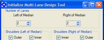
13 Initialize Multi-Lane Design Tool Number of Lanes Shoulders Traffic in Direction of Input Line Roadway Point Names Automatic Point Numbering Custom Median 12 12


14 Multi-Lane Design Tool Roadways, Shoulders, Terrain Lines, and Ground Zone Design Input Line Geometry Copy Tools Back to Initialization Create Roadways, Shoulders, Terrain Lines, and Ground Zone Quit Multi- Lane Design w/o saving 13 13


15 Gray Shoulder TNM Objects Created Black Roadway Terrain Lines for Median Cross Section Shoulder Width Roadway Width Ground Zone for Median 14 14
16 File Import / Export Importing Drawings Autocad (.dxf,.dwg) ESRI (.shp) Microstation (.dgn) Exporting Drawings Autocad (.dxf,.dwg) ESRI (.shp) Importing Aerial Photographs Non-georeferenced (.jpg) Georeferenced (.tiff) 15 15


17 DXF Import 16 16


18 Image Import NAD 83 State Plane Alabama West FIPS foot resolution 17 17
19 Reports Report, the New Table Print/Export from: Report Print/Export Reports dialog Printing Improved Functionality PDF Export Automatic after calculation Separate files or Combined file Excel Export Separate files or Combined file (pending) 18 18


20 Results: No Barrier Objects: Sound Levels 19 19
21 Results: Input Heights: Sound Levels 20 20
22 Excel Export 21 21


23 PDF Export 22 22
24 Sound-level Input: Receivers 23 23
Bentley ConceptStation Workshop 2017 FLUG Spring Training Event
 Bentley ConceptStation Workshop 2017 FLUG Spring Training Event 430 - QuickStart using OpenRoads ConceptStation Bentley Systems, Incorporated 685 Stockton Drive Exton, PA 19341 www.bentley.com Practice
City of La Crosse Online Mapping Website Help Document
 City of La Crosse Online Mapping Website Help Document This document was created to assist in using the new City of La Crosse online mapping sites. When the website is first opened, a map showing the City
QUICK START GUIDE. SOLO Forest
 QUICK START GUIDE SOLO Forest Software Installation 1. For PC installation, run the.msi file. 2. For Mobile device installation, copy the.cab file onto the device 3. Run the.cab file Starting the Program
Bentley OpenRoads Workshop 2017 FLUG Fall Training Event
 Bentley OpenRoads Workshop 2017 FLUG Fall Training Event F-1E - QuickStart using OpenRoads ConceptStation Bentley Systems, Incorporated 685 Stockton Drive Exton, PA 19341 www.bentley.com Practice Workbook
Objectives Learn how to work with projections in GMS, and how to combine data from different coordinate systems into the same GMS project.
 v. 10.2 GMS 10.2 Tutorial Working with map projections in GMS Objectives Learn how to work with projections in GMS, and how to combine data from different coordinate systems into the same GMS project.
MicroStation XM/V8i/SS1
 MicroStation XM/V8i/SS1 1 By Rande Robinson THE LEGAL STUFF (The stuff my bosses make me add.) 2 The Opinions (no matter how well thought out they are) expressed in this presentation are my own and do
v Working with Rasters SMS 12.1 Tutorial Requirements Raster Module Map Module Mesh Module Time minutes Prerequisites Overview Tutorial
 v. 12.1 SMS 12.1 Tutorial Objectives This tutorial teaches how to import a Raster, view elevations at individual points, change display options for multiple views of the data, show the 2D profile plots,
Highway Performance Monitoring System
 Highway Performance Monitoring System Version 1.0 June 2011 Quick Start Guide for Version 8.0 Federal Highway Administration Table of Contents Chapter 1 Introduction... 1 Chapter 2 HPMS Workflow... 2 Chapter
Objectives Learn how to work with projections in SMS, and how to combine data from different coordinate systems into the same SMS project.
 v. 12.2 SMS 12.2 Tutorial Working with map projections in SMS Objectives Learn how to work with projections in SMS, and how to combine data from different coordinate systems into the same SMS project.
SoundPLAN Designing a Sound Environment
 SoundPLAN Designing a Sound Environment A&WMA Ontario Section Air Quality and Environmental Acoustic Modeling Conference October 22, 2013 Presented by Hans Forschner Navcon Engineering Network Trends North-America
Objectives Learn how to work with projections in SMS, and how to combine data from different coordinate systems into the same SMS project.
 v. 12.3 SMS 12.3 Tutorial Working with map projections in SMS Objectives Learn how to work with projections in SMS, and how to combine data from different coordinate systems into the same SMS project.
Objectives This tutorial shows how to build a Sedimentation and River Hydraulics Two-Dimensional (SRH-2D) simulation.
 simulation.") v. 12.1 SMS 12.1 Tutorial Objectives This tutorial shows how to build a Sedimentation and River Hydraulics Two-Dimensional () simulation. Prerequisites SMS Overview tutorial Requirements Model Map Module
v. 12.1 SMS 12.1 Tutorial Objectives This tutorial shows how to build a Sedimentation and River Hydraulics Two-Dimensional () simulation. Prerequisites SMS Overview tutorial Requirements Model Map Module
Convert AutoCAD files to ESRI ShapeFiles, to be used in Leica icon telematics
 Convert AutoCAD files to ESRI ShapeFiles, to be used in 1 1 Convert AutoCAD files to ESRI ShapeFiles, to be used in Background When you use it is possible to log the machine's position and visualize this
Tec Sheet NoiseMod Reverse.3pc
 What is NoiseModReverse.3pc? NoiseModReverse.3pc HELP DOCUMENTATION NoiseModReverse.3pc is a Geopak application that reads a FHWA Stamina noise model ASCII file and draws the roadways, barriers, and receivers
Creating Printed Output
 Creating Printed Output Module Overview This module will help you to become familiar with the options that let you produce quality printed output. Module Prerequisites Fundamental knowledge of the Microsoft
Accessing Rhino Page Layouts
 Accessing Rhino Page Layouts In this exercise, we will use the Page (Sheet) Layout feature to create sheet with Details and title block. The Details will include text and dimensions that are sized correctly
A Practical Guide to Using QGIS
 A Practical Guide to Using QGIS 1.1 INTRODUCTION Quantum GIS (QGIS) is a useful mapping software that enables the compilation and displaying of spatial data in the form of a map. Gaining experience in
Import, view, edit, convert, and digitize triangulated irregular networks
 v. 10.1 WMS 10.1 Tutorial Import, view, edit, convert, and digitize triangulated irregular networks Objectives Import survey data in an XYZ format. Digitize elevation points using contour imagery. Edit
v SMS Tutorials Working with Rasters Prerequisites Requirements Time Objectives
 v. 12.2 SMS 12.2 Tutorial Objectives Learn how to import a Raster, view elevations at individual points, change display options for multiple views of the data, show the 2D profile plots, and interpolate
Page 1 of 16 CONTENTS:
 Page 1 of 16 CONTENTS: HOME-BOX -- (PG.2) o PROPERTY OWNERSHIP o ADDRESS SEARCH o I WANT TO AERIAL IMAGERY AND BASE MAPS -- (PG.2) o IMAGERY WITH LABELS ON/OFF o TOPOGRAPHY ON/OFF o TRANSPARENCY ZOOM IN
v SMS Tutorials SRH-2D Prerequisites Requirements SRH-2D Model Map Module Mesh Module Data files Time
 v. 11.2 SMS 11.2 Tutorial Objectives This tutorial shows how to build a Sedimentation and River Hydraulics Two-Dimensional () simulation using SMS version 11.2 or later. Prerequisites SMS Overview tutorial
US Geo-Explorer User s Guide. Web:
 US Geo-Explorer User s Guide Web: http://usgeoexplorer.org Updated on October 26, 2016 TABLE OF CONTENTS Introduction... 3 1. System Interface... 5 2. Administrative Unit... 7 2.1 Region Selection... 7
Producing Project Deliverables: Creating a Plan Set
 Practice Workbook This workbook is designed for use in Live instructor-led training and for OnDemand selfstudy. The explanations and demonstrations are provided by the instructor in the classroom, or in
All data is in Universal Transverse Mercator (UTM) Zone 6 projection, and WGS 84 datum.
 Zone 6 projection, and WGS 84 datum.") 111 Mulford Hall, College of Natural Resources, UC Berkeley (510) 643-4539 EXPLORING MOOREA DATA WITH QUANTUM GIS In this exercise, you will be using an open-source FREE GIS software, called Quantum GIS,
111 Mulford Hall, College of Natural Resources, UC Berkeley (510) 643-4539 EXPLORING MOOREA DATA WITH QUANTUM GIS In this exercise, you will be using an open-source FREE GIS software, called Quantum GIS,
Objectives Learn how to work with projections in GMS, and how to combine data from different coordinate systems into the same GMS project.
 v. 10.4 GMS 10.4 Tutorial Working with map projections in GMS Objectives Learn how to work with projections in GMS, and how to combine data from different coordinate systems into the same GMS project.
A Step-by-step guide to creating a Professional PowerPoint Presentation
 Quick introduction to Microsoft PowerPoint A Step-by-step guide to creating a Professional PowerPoint Presentation Created by Cruse Control creative services Tel +44 (0) 1923 842 295 training@crusecontrol.com
: Atoll : General Features (UMTS HSPA Platform)
") Atoll 3.1.0 Training Exercise Book : Atoll : General Features (UMTS HSPA Platform) Creating an Atoll document Importing geographic data Creating a new station Grouping and filtering radio data Creating
Atoll 3.1.0 Training Exercise Book : Atoll : General Features (UMTS HSPA Platform) Creating an Atoll document Importing geographic data Creating a new station Grouping and filtering radio data Creating
Tutorial (Beginner level): Orthomosaic and DEM Generation with Agisoft PhotoScan Pro 1.3 (with Ground Control Points)
: Orthomosaic and DEM Generation with Agisoft PhotoScan Pro 1.3 (with Ground Control Points)") Tutorial (Beginner level): Orthomosaic and DEM Generation with Agisoft PhotoScan Pro 1.3 (with Ground Control Points) Overview Agisoft PhotoScan Professional allows to generate georeferenced dense point
Tutorial (Beginner level): Orthomosaic and DEM Generation with Agisoft PhotoScan Pro 1.3 (with Ground Control Points) Overview Agisoft PhotoScan Professional allows to generate georeferenced dense point
Guide to Mapping Website (Public) December 2016 GC_236594
 December 2016 GC_236594") Guide to Mapping Website (Public) December 2016 GC_236594 Table of Contents Guide to Mapping Website (Public)... 1 December 2016... 1 Quick Start... 3 Map Layers... 4 How do I?... 5 Draw on the Map...
Guide to Mapping Website (Public) December 2016 GC_236594 Table of Contents Guide to Mapping Website (Public)... 1 December 2016... 1 Quick Start... 3 Map Layers... 4 How do I?... 5 Draw on the Map...
v Annotation Tools GMS 10.4 Tutorial Use scale bars, North arrows, floating images, text boxes, lines, arrows, circles/ovals, and rectangles.
 v. 10.4 GMS 10.4 Tutorial Use scale bars, North arrows, floating images, text boxes, lines, arrows, circles/ovals, and rectangles. Objectives GMS includes a number of annotation tools that can be used
STUDENT PAGES GIS Tutorial Treasure in the Treasure State
 STUDENT PAGES GIS Tutorial Treasure in the Treasure State Copyright 2015 Bear Trust International GIS Tutorial 1 Exercise 1: Make a Hand Drawn Map of the School Yard and Playground Your teacher will provide
To show toolbars, double-click in the banner at the top or click the tools icon
 8/15/2013 Welcome to Culver City s GIS Property Information Search 2.0. This instructional document provides an overview of most commonly used functionality in this streamlined, enhanced web map application.
XYZ Mesh. Product. Gray Technical, LLC Copyright Gray Technical All Rights Reserved
 Product XYZ Mesh Company Copyright License Gray Technical, LLC http://www.graytechnical.com/ XYZ Mesh Copyright Copyright 2015-2017 Gray Technical All Rights Reserved SOFTWARE LICENSE SOFTWARE REPRODUCTION:
SURFACE WATER MODELING SYSTEM. This tutorial requires that you have Google Earth installed on your computer.
 SURFACE WATER MODELING SYSTEM Google Earth Files This lesson is designed to help you understand how to save SMS data to a *.kmz file format. Files of this type are Google Earth files and will allow you
Explore some of the new functionality in ArcMap 10
 Explore some of the new functionality in ArcMap 10 Scenario In this exercise, imagine you are a GIS analyst working for Old Dominion University. Construction will begin shortly on renovation of the new
Lesson 15 Working with Tables
 Working with Tables Computer Literacy BASICS: A Comprehensive Guide to IC 3, 4 th Edition 1 Objectives Create a table and insert text. Insert and delete rows and columns. Adjust column width and row height.
CHAPTER 11. Learn to use GEOPAK Automated Superelevation dialog box and Autoshape Builder to apply superelevation to a roadway.
 CHAPTER 11 Superelevation 11.1 Introduction Objectives Project Manager Learn to use GEOPAK Automated Superelevation dialog box and Autoshape Builder to apply superelevation to a roadway. Calculate Superelevation
Basic Mapping: Livelihood Zones In Haiti
 Basic Mapping: Livelihood Zones In Haiti - 2009 Barbara Parmenter, revised by Carolyn Talmadge 9/10/2017 for ArcMap 10.5.1 DATA SOURCES... 1 MAPPING NETWORK DRIVES OUTSIDE THE DATA LAB... 2 SETTING UP
IBM TRIRIGA Application Platform Version 3.2. Graphics User Guide. Copyright IBM Corp i
 IBM TRIRIGA Application Platform Version 3.2 Graphics User Guide Copyright IBM Corp. 2011 i Note Before using this information and the product it supports, read the information in Notices on page 31. This
Lesson 15 Working with Tables
 Working with Tables Computer Literacy BASICS: A Comprehensive Guide to IC 3, 5 th Edition 1 Objectives Create a table and insert text. Insert and delete rows and columns. Adjust column width and row height.
NCDOT Civil Geometry for GEOPAK Users
 2018 NCDOT Civil Geometry for GEOPAK Users Oak Thammavong NCDOT Roadway Design Unit 7/31/2018 This page left intentionally blank Copyright 2018 NCDOT DO NOT DISTRIBUTE Printing for student use is permitted
SMS v D Summary Table. SRH-2D Tutorial. Prerequisites. Requirements. Time. Objectives
 SMS v. 12.3 SRH-2D Tutorial Objectives Learn the process of making a summary table to compare the 2D hydraulic model results with 1D hydraulic model results. This tutorial introduces a method of presenting
Development Authority of the North Country (DANC) Internet Mapping Application Instructions Public Viewer 1. Purpose. 2. Logging-in. 3.
 Internet Mapping Application Instructions Public Viewer 1. Purpose. 2. Logging-in. 3.") Development Authority of the North Country (DANC) Internet Mapping Application Instructions Public Viewer 1. Purpose The purpose of this document is to outline basic functionality of the DANC Internet
Development Authority of the North Country (DANC) Internet Mapping Application Instructions Public Viewer 1. Purpose The purpose of this document is to outline basic functionality of the DANC Internet
IBM TRIRIGA Application Platform Version 3.3. Graphics User Guide. Copyright IBM Corp i
 IBM TRIRIGA Application Platform Version 3.3 Graphics User Guide Copyright IBM Corp. 2011 i Note Before using this information and the product it supports, read the information in Notices on page 33. This
ANALYSIS SOFTWARE. CAmReport
 ANALYSIS SOFTWARE CAmReport ENGLISH User Manual CONTENTS 1. INSTALLATION... 3 2. GETTING STARTED... 4 2.1 Starting and Exiting CAmReport... 4 2.2 Setup... 4 2.2.1 Language... 4 2.2.2 Units... 4 2.2.3 CAmReport
CET Designer 9.5 Release Notes
 CET Designer 9.5 Release Notes November 19, 2018 Important Notices Starting from this release, CET Designer is only available in a 64-bit version. For computers with damaged graphics drivers or a graphics
button in the lower-left corner of the panel if you have further questions throughout this tutorial.
 Mosaic Tutorial: Simple Workflow This tutorial demonstrates how to use the Seamless Mosaic tool to mosaic six overlapping digital aerial scenes. You will learn about displaying footprints and image data
Roadway Alignments and Profiles
 NOTES Module 15 Roadway Alignments and Profiles In this module, you learn how to create horizontal alignments, surface profiles, layout (design) profiles, and profile views in AutoCAD Civil 3D. This module
MANITOBA LAND USE AND DEVELOPMENT WEB APPLICATION: How-to guide and help document
 MANITOBA LAND USE AND DEVELOPMENT WEB APPLICATION: How-to guide and help document 2 Index Index... 2 Layout & View... 3 Overview... 3 Layers... 4 Municipal Relations Data Layers... 4 Application Toolbar...
CET Designer 9.5 Release Notes
 CET Designer 9.5 Release Notes Important Notices Starting from this release, CET Designer is only available in a 64-bit version. For computers with damaged graphics drivers or a graphics unit that does
Presenting Highway Noise Exposures The Downfall of Contourtionists
 Presenting Highway Noise Exposures The Downfall of Contourtionists Michael A. Staiano, Staiano Engineering, Inc., Rockville, Maryland This article is intended as a cautionary guide to estimating noise
Spring 2011 Workshop ESSENTIALS OF 3D MODELING IN RHINOCEROS February 10 th 2011 S.R. Crown Hall Lower Core Computer Lab
 [1] Open Rhinoceros. PART 1 INTRODUCTION [4] Click and hold on the Boundary Lines in where they form a crossing and Drag from TOP RIGHT to BOTTOM LEFT to enable only the PERSPECTIVE VIEW. [2] When the
Importing and Exporting FilesChapter1:
 Importing and Exporting FilesChapter1: Chapter 1 You can use Revit Architecture to import and export various file types, including AutoCAD and AutoCAD Architecture DWG files to use as design aids. You
PowerPoint for Art History Presentations
 PowerPoint for Art History Presentations For PC computers running Microsoft Office 2007+ Adapted by The University of California, Berkeley from the Institute of Fine Arts document by Elizabeth S. Funk
MAG Demographic Map Viewer Training
 Exercise 1 In this exercise you will create a map showing the percentage of Hispanic population of each block group, showing eight data breaks using equal intervals, an orange and purple color scheme,
Pen & Ink Writer. User Guide
 Pen & Ink Writer User Guide 1 Table of Contents Pen & Ink Writer.....4 Pen & Ink Main Window...5 The Writing Area...9 Margins and Grids...12 Editing...13 Editing the Line Properties...13 Changing the Line
Introduction to SAGA GIS
 GIS Tutorial ID: IGET_RS_001 This tutorial has been developed by BVIEER as part of the IGET web portal intended to provide easy access to geospatial education. This tutorial is released under the Creative
Integrated Diagramming Tool Easy Street Draw
 Integrated Diagramming Tool Easy Street Draw CRASH User Guide - 1 Version Control Date Version Author(s) Section(s) Update(s) 8/24/2011 1 S Kirkpatrick, J Castillo, H Campbell, D Williams, M McCormick,
Marushka Server. Product Specification
 Introductory Information Product Marushka Server represents a new generation of tools (devices) for publication and use of GIS data in the Internet and intranet. It is built on component technology in.net
Tutorial Tracing and Machining Images
 Getting Started With Tutorial Tracing and Machining Images VCarve Pro Disclaimer All CNC machines (routing, engraving, and milling) are potentially dangerous and because Vectric Ltd has no control over
Bentley OpenBridge Workshop 2017 FLUG Spring Training Event
 Bentley OpenBridge Workshop 2017 FLUG Spring Training Event 435 - Using Open Bridge Modeler and Lumenr RT Bentley Systems, Incorporated 685 Stockton Drive Exton, PA 19341 www.bentley.com Practice Workbook
GIS Virtual Workshop: Buffering
 This workshop will teach the different methods of buffering data. They will include: Basic buffering of data Merging buffering zones Clipping the buffer Concentric rings around the object You will find
Getting to Know ArcGIS Pro
 Getting to Know ArcGIS Pro SUPPLEMENT FOR ARCGIS PRO 2.2 Getting to Know ArcGIS Pro, first edition, published in 2016, was written and tested on ArcGIS Pro 1.1. Since then, the capabilities and user interface
GIMP WEB 2.0 BUTTONS
 GIMP WEB 2.0 BUTTONS Web 2.0 Navigation: Web 2.0 Button with Navigation Arrow GIMP is all about IT (Images and Text) WEB 2.0 NAVIGATION: BUTTONS_WITH_NAVIGATION_ARROW This button navigation will be designed
IHS Enerdeq Desktop International Training Guide
 IHS > Decision Support Tool IHS Enerdeq Desktop International Training Guide May 2009 Version 1.5.2 2009 IHS, All Rights Reserved. All trademarks belong to IHS or its affiliated and subsidiary companies,
INTRODUCTION... 1 UNDERSTANDING CELLS... 2 CELL CONTENT... 4
 Introduction to Microsoft Excel 2016 INTRODUCTION... 1 The Excel 2016 Environment... 1 Worksheet Views... 2 UNDERSTANDING CELLS... 2 Select a Cell Range... 3 CELL CONTENT... 4 Enter and Edit Data... 4
Launch QGIS. Launch QGIS from. Open window Quantum GIS (Figure 1.1 below) Start All Programs Quantum GIS. QGISIcon on the desk top
 Start All Programs Quantum GIS. QGISIcon on the desk top") QGIS Launch QGIS Launch QGIS from Start All Programs Quantum GIS OR QGISIcon on the desk top Open window Quantum GIS (Figure 1.1 below) 2 Figure 1.1 3 Opening Raster For this exercise we demonstrate three
QGIS Launch QGIS Launch QGIS from Start All Programs Quantum GIS OR QGISIcon on the desk top Open window Quantum GIS (Figure 1.1 below) 2 Figure 1.1 3 Opening Raster For this exercise we demonstrate three
External and Unique Instrument Spec Sheets
 External and Unique Instrument Spec Sheets FLUOR SmartPlant Implementation Team Copyright 2005 Fluor Corporation all rights reserved Editable External Spec Sheets Many SPI users need specs that can be
Using Interactive Reports and Dashboards
 Using Interactive Reports and Dashboards Typical interactive features Use onscreen filters to modify a dashboard or report and choose whether to see all or only some of the data available. The screen will
Overview September 7, 2017
 Overview September 7, 2017 Purpose The purpose of this presentation is to provide an overview of the changes to the required deliverables and workflow for developing plans and models for Illinois DOT projects
Epilog Laser Cutter Instructions (Only the Essentials)
") Epilog Laser Cutter Instructions (Only the Essentials) How to export a file for SKETCHUP put it on the server, open it in Illustrator, and Prepare it for the Epilog Laser Cutter 1. In Sketchup: Draw a
Epilog Laser Cutter Instructions (Only the Essentials) How to export a file for SKETCHUP put it on the server, open it in Illustrator, and Prepare it for the Epilog Laser Cutter 1. In Sketchup: Draw a
M c i r c os o t S at a io i n o n an a d n d A lll lth T i h n i g n s g s P D P F Agenda
 MicroStation and All Things PDF Agenda Basic PDF Creation from within MicroStation PDF Printer Drivers Printing 3D Design Geometry to a PDF File Sending Geospatial Data to a PDF Exporting Business Data
Astra Scheduling Grids
 Astra Scheduling Grids To access the grids, click on the Scheduling Grids option from the Calendars tab. A default grid will be displayed as defined by the calendar permission within your role. Choosing
Workshop #1: Set Up Project File and RAS Mapper
 Workshop #1: Set Up Project File and RAS Mapper 1 In this workshop, you will: Install and open HEC-RAS 5.0.3 Create a project file Obtain terrain and projection data Import terrain data into RAS Mapper
Manitowoc County, WI Advanced Access GIS Viewer User Documentation
 Manitowoc County, WI Advanced Access GIS Viewer User Documentation Introduction Extensive time was put into developing this website both from a display, and from a printing and scaling perspective. This
EFC-400 Release 2006 now with added cartographic function features
 EFC-400 Release 2006 now with added cartographic function features Overview of the new features: Ground profiles with up to 5000 x 5000 points Storage of sets of cartographic test data New components added
USING DATA DRIVEN PAGES
 USING DATA DRIVEN PAGES Mid-West ESRI Utility User s Group Conference March 26, 2014 Presented by: Hillary Bjorstrom, GIS Analyst STAR Energy Services LLC Alexandria, Minnesota EXERCISE 1 CREATING A GRID
3DReshaper Help DReshaper Beginner's Guide. Surveying
 3DReshaper Beginner's Guide Surveying 1 of 29 Cross sections Exercise: Tunnel analysis Surface analysis Exercise: Complete analysis of a concrete floor Surveying extraction Exercise: Automatic extraction
ArcGIS. ArcGIS Desktop. Tips and Shortcuts
 ArcGIS ArcGIS Desktop Tips and Shortcuts Map Navigation Function Shortcut Availability Refresh and redraw the display. F5 9.1, Suspend the map s drawing. F9 9.1, Zoom in and out. Center map. Roll the mouse
OnCOR Silverlight Viewer Guide
 Getting Around There are many ways to move around the map! The simplest option is to use your mouse in the map area. If you hold the left button down, then click and drag, you can pan the map to a new
1. Folder Structure, Terrain Feature Dataset, and Geodatabase Creation
 1. Folder Structure, Terrain Feature Dataset, and Geodatabase Creation You will be working with a lot of different files and it is important to keep them organized so that is easy to place and locate things.
HEC-RAS 5.0 Training New Zealand Workshop Guide
 HEC-RAS 5.0 Training New Zealand Workshop Guide Prepared by: Krey Price Surface Water Solutions 57 Bromfield Drive Kelmscott WA 6111 Australia Tel. +61 400 367 542 e-mail: info@surfacewater.biz website:
Display Layers in Geosoft 3D View
 Use the New 2D/3D Workflow features in Target for ArcGIS In Target for ArcGIS version 3.5, there are three new interconnected features that make integrating 2D and 3D data in plan and section maps easier.
Lesson 5 - Creating Prescription Maps. Exercise 5-1
 Lesson 5 - Creating Prescription Maps Exercise 5-1 Objective: Create a phosphorus prescription map based on the University of Nebraska-Lincoln recommendations. 1. File-Open Project_5-0.map. The required
ENVI Tutorial: Interactive Display Functions
 ENVI Tutorial: Interactive Display Functions Table of Contents OVERVIEW OF THIS TUTORIAL...2 OPENING A PANCHROMATIC (SPOT) IMAGE FILE...2 PERFORMING INTERACTIVE CONTRAST STRETCHING...2 Linear Stretching
Tutorial files are available from the Exelis VIS website or on the ENVI Resource DVD in the image_reg directory.
 Image Registration Tutorial In this tutorial, you will use the Image Registration workflow in different scenarios to geometrically align two overlapping images with different viewing geometry and different
Basic Mapping: Livelihood Zones In Haiti
 Basic Mapping: Livelihood Zones In Haiti - 2009 Barbara Parmenter, revised by Carolyn Talmadge 9/10/2016 DATA SOURCES... 1 MAPPING NETWORK DRIVES OUTSIDE THE DATA LAB... 2 SETTING UP YOUR ARCMAP SESSION...
CounselLink Reporting. Designer
 CounselLink Reporting Designer Contents Overview... 1 Introduction to the Document Editor... 2 Create a new document:... 2 Document Templates... 3 Datasets... 3 Document Structure... 3 Layout Area... 4
Bentley Civil Workshop
 Bentley Civil Workshop 2013 Bentley LEARNing Conference BCR2WK4 Creating End Conditions Team Leader: Dave Hoerner Team Members: Lisa Whitson & Derricke Gray Bentley Systems, Incorporated 685 Stockton Drive
ArcGIS Basics: Mapping the US
 ArcGIS Basics: Mapping the US Revised February 15, 2010 Tufts University Author: Barbara Parmenter Introduction...1 Part 1 - Opening ArcMap and adding data layers...1 Part 2 Moving around the Map...4 Part
D2M2 - GIS USER'S MANUAL
 D2M2 - GIS USER'S MANUAL USACE ERDC, July 2012 1 Content Overview of D2M2... 3 User Interface... 4 Menus... 4 File Menu... 4 Edit Menu... 5 View Menu... 5 Layer Menu... 6 Analysis Menu... 6 Tools Menu...
ENVI Classic Tutorial: Interactive Display Functions 2
 ENVI Classic Tutorial: Interactive Display Functions Interactive Display Functions 2 Files Used in this Tutorial 2 Opening a Panchromatic (SPOT) Image File 3 Performing Interactive Contrast Stretching
Quick Start Guide. ASR Automated Systems Research Inc. Toll free: Fax:
 Quick Start Guide ASR Automated Systems Research Inc. Toll free: 1-800-818-2051 Phone: 604-539-0122 e-mail: support@asrsoft.com Fax: 604-539-1334 www.asrsoft.com Copyright 1991-2014 ASR Automated Systems
User Manual.
 User Manual www.gridsoftware.com Table of Contents SCL Matrix Overview...4 1. Startup Screen...5 2. Ribbon...7 2.1. Home...8 2.2. Engineering Process...9 2.3. Add...10 2.4. Import/Export...11 3. Projects...12
7/14/2009. Chapters Autocad Multi Line Text Tools. Multi Line Text Tool Ribbon. Multi Line Text Tool. July 14, 2009
 Chapters 9-11 July 14, 2009 Chapter 9 Learning Objectives Describe and use proper text standards. Calculate drawing scale and text height. Develop and use text styles. Make multiple lines of text with
SolarSpeed Calculator INSTRUCTION MANUAL
 SolarSpeed Calculator INSTRUCTION MANUAL Login or register at https://solarspeed.avasco.be Registering Calculator. Click on Register at the homepage https://solarspeed.avasco.be. Fill in all fields (*
Interactive Highway Safety Design Model (IHSDM) Workshop Nevada DOT Las Vegas, NV February 13, 2014
 Workshop Nevada DOT Las Vegas, NV February 13, 2014") Interactive Highway Safety Design Model (IHSDM) Workshop Nevada DOT Las Vegas, NV February 13, 2014 Overview Hands-on Exercises: IHSDM Crash Prediction Module (CPM) The Crash Prediction Module estimates
Interactive Highway Safety Design Model (IHSDM) Workshop Nevada DOT Las Vegas, NV February 13, 2014 Overview Hands-on Exercises: IHSDM Crash Prediction Module (CPM) The Crash Prediction Module estimates
QGIS Workshop Su Zhang and Laura Gleasner 11/15/2018. QGIS Workshop
 1. Introduction to QGIS QGIS Workshop QGIS is a free and open source Geographic Information System (GIS). QGIS can help users create, edit, visualize, analyze, and publish geospatial information on various
Excel Core Certification
 Microsoft Office Specialist 2010 Microsoft Excel Core Certification 2010 Lesson 6: Working with Charts Lesson Objectives This lesson introduces you to working with charts. You will look at how to create
Presentations Made Easy customizing graphs
 Presentations Made Easy customizing graphs How to Graph a Report Once you have selected the media and target(s) and your report is displayed, click on the GRAPH button. A list of graph types will appear