INTRODUCTION TO Accelerating Data Collection with Unmanned Aircraft Systems
|
|
|
- Maryann Edwards
- 5 years ago
- Views:
Transcription


1 INTRODUCTION TO Accelerating Data Collection with Unmanned Aircraft Systems Kyle Kukuk Terry Pallotto MWCC Enviromental Conference July 10-12, 2016


2 Who is Here? Kyle Kukuk, PE Project Manager Blackstone Environmental Terry Pallotto, PE Operations Manager Tukuh Technologies, LLC


3 Organization Tribally-owned 8(a) Small Business Owned by the Paskenta Band of Nomlaki Indians of Northern CA National company based in Kansas City, MO Technology Services Offered Geospatial solutions: GIS services, aerial mapping, survey Managed IT and application development Staff augmentation


4 UAV Mapping

5 Unmanned Aircraft Systems Basics    Known as UAS Four components: Aircraft Sensor Payload Ground Control Station Operator Highly accurate geospatial data Faster mobilization and acquisition times Lower cost Lower risk


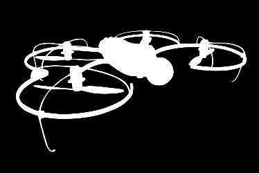
 Multi-Rotor UAS")

6 UAS Platforms Fixed-wing UAS Orthophoto Creation Digital Surface Modeling 3D Visualization Remote Sensing (NDVI, NIR Camera) Multi-Rotor UAS Real-time Video Inspections Video Presentations Oblique Photography Inspections Thermal Imaging
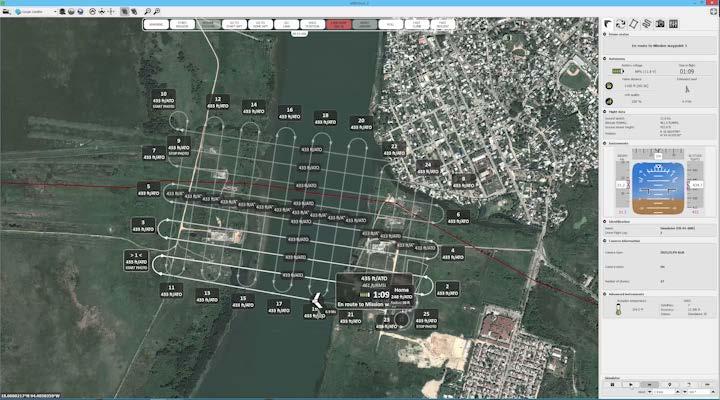
7 Data Acquistion

8 Image Processing and Photogrammetry


9 The Process } Models Simulations Videos Maps XYZ Data Collection Other Data Sets Processing Geospatial-Based Products

10 Expected Accuracy  Meets or exceeds conventional photogrammetry GSD down to 1.5 cm Relative 3D model accuracy 1 to 3x GSD Absolute horizontal/vertical accuracy to 3 to 5 cm
11 Typical Deliverables F G F G F G F G F G F G 0 F G F G Source: Esri, DigitalGlobe, GeoEye, Earthstar Geographics, CNES/Airbus DS, USDA, USGS, AEX, Getmapping, Aerogrid, IGN, IGP, swisstopo, and the GIS User Community
12 Typical Deliverables Source: Esri, DigitalGlobe, GeoEye, Earthstar Geographics, CNES/Airbus DS, USDA, USGS, AEX, Getmapping, Aerogrid, IGN, IGP, swisstopo, and the GIS User Community

13 Benefits for Solid Waste Industry  Digital Mapping Survey-grade Dense point clouds High-resolution Imagery  Traditional deliverables Orthomosaics Planimetrics Digital surface and terrain models Contours 3D TIN models

14 Relative Costs   Acquisition costs as much as 50% less than conventional aircraft UAS less to buy & maintain  UAS less to hire than pilots/camera operators  Multiple Aircraft may be used in tandem  Mobilized quickly

15 Controlling Costs Comparison of UAS vs. Conventional Aerial Acquisition $30,000 $25,000 $20,000 $15,000 $10,000 $5,000 $- $25,820 $20,487 $16,338 $15,876 $16,184 $8,400 $9,900 $5,200 Mine Reclamation Site Landfill Mine Reclamation Site 4 Mine Reclamation Sites UAV Conventional

16 FAA Section 333 Exemption  Awarded in June 2015  Safety first/risk mitigation Professional pilots, not hobbyists  Tukuh s differentiators Licensed pilots 2+ years R&D Best practices and SOP
 1. In-person knowledge test and TSA background check 2.")
, 3.")
17 The Rules are Changing Current Rules Require a licensed pilot No flights over persons not directly involved in the operation. Proposed Rule Changes FAA airman certification (currently hotly debated) 1. In-person knowledge test and TSA background check 2. Online knowledge test and no background check Four new categories defined by level of risk of injury for operations over people 1. Cat 1: < ½ lbs No restrictions 2. Cat 2: < 5 lbs must stay at least 20 ft above and 10 ft lateral to people (Joules 2-4), 3. Cat 3: < 55 lbs No flights over crowds except those who are transient or incidental to the operation 4. Cat 4: Same as 3 except flights over crowds allowed with risk mitigation plan coordinated with local stakeholders


18 Risk Factors

19 Qualified Personnel
20 Meteorological Conditions
21 Project Examples

22 Projects Flown and Mapped

23 Black Oak Landfill near Hartville, MO Aerial Orthophotography 1.5 GSD Topographical Mapping Dense Point Cloud 3D TIN Model 1 Contours

24 Bondad Landfill, near Durango, CO Aerial Orthophotography 1.5 GSD Topographical Mapping Dense Point Cloud 3D TIN Model 1 Contours

25

26 Prairie View Landfill near Lamar, MO Aerial Orthophotography 1.5 GSD Topographical Mapping Dense Point Cloud 3D TIN Model 1 Contours


27 Johnson County Landfill, KS Design Topo As-Built Topo

28 Cherokee County OU-4 Superfund Site near Treece, Kansas Aerial Orthophotography 1.5 GSD Topographical Mapping Dense Point Cloud 3D TIN Model 1 Contours

29 MO Highway V Site near Foster, MO Aerial Orthophotography 1.5 GSD Topographical Mapping Dense Point Cloud 3D TIN Model 2 Contours Planimetrics
30 St Joe Landfill

31 St Joe Landfill Aerial Orthophotography 1.5 GSD Topographical Mapping Dense Point Cloud 3D TIN Model 1 Contours Airspace Calculations
32 MDNR Biennial Airspace Estimates Airspace filled in last 2 years. Total airspace filled to date. Remaining airspace Show waste extents Provide MDNR with updated topo


33 High Definition Aerial Imagery Created from over 500 individual photos 5 flight lifts used

34 3-D Point Cloud

35 Topographic Contour Map 1-ft contours Contour map provided to MDNR in submittal

36 3-D Surface Modal

37 Airspace Used

38 Remaining Airspace
39 Other Uses for UAV Surveys at Landfills Stockpile / borrow pit analysis Liner surveys Final cover surveys Waste density / compaction estimates Tracking vegetation growth Assessing pond berms, dikes, and outfalls Inspection and monitoring of hard-to-reach landfill areas Thermographic (I/R) survey to monitor surface temperature
40 Additional Examples

41 Turkey Creek Flood Control 4k video flown with the DJI Inspire. Image stabilization Geospatially accurate features composited into video

42 Our Portfolio Fort Leavenworth Bldg 52/102 Aerial Orthophotography 1.5 GSD Topographical Mapping Dense Point Cloud 3D TIN Model 2 Contours 3D Modeling Aerial Obliques Orthoplane Photos

43 Our Portfolio KCP&L Substation, Weston, MO Aerial Orthophotography 1.5 GSD Topographical Mapping Dense Point Cloud 3D TIN Model 1 Contours 200 Scale Planimetrics
 956-6223 kkukuk@blackstone-env.")
44 QUESTIONS? Want to talk some more offline? Terrence Pallotto, PE Operations Manager, Tukuh Kyle Kukuk, PE Project Manager, Blackstone Environmental (913)
UAV s in Surveying: Integration/processes/deliverables A-Z. 3Dsurvey.si
 UAV s in Surveying: Integration/processes/deliverables A-Z Info@eGPS.net TODAY S PROGRAM Introduction to photogrammetry and 3Dsurvey Theoretical facts about the technology and basics of 3dsurvey Introduction
Quality Accuracy Professionalism
 GeoWing - who are we? Mapping Data Service Provider Lidar Multispectral Topographic and Planimetric Maps Elevation Models Point Clouds / 3D Models Orthophotography FAA-Authorized UAS Operators WOSB / DBE
2/9/2016. Session Agenda: Implementing new Geospatial Technologies for more efficient data capture
 Implementing new Geospatial Technologies for more efficient data capture Jay Haskamp Applied Geospatial Engineer Steve Richter VP Sales Session Agenda: Today s changing technologies and what lies ahead
Unmanned Aerial Systems: A Look Into UAS at ODOT
 Ohio Department of Transportation John R. Kasich, Governor Jerry Wray, Director Unmanned Aerial Systems: Tim Burkholder, PS Mapping Manager Division of Engineering Office of CADD and Mapping Services Kyle
Harnessing GIS and Imagery for Power Transmission Inspection. ESRI European Users Conference October 15, 2015
 Harnessing GIS and Imagery for Power Transmission Inspection ESRI European Users Conference October 15, 2015 About Us Airborne/Threod Designer, manufacturer & service provider for multi-rotor & fixed wing
H2H Associates, LLC Innovative Mapping Technologies, LLLP
 H2H Associates, LLC Innovative Mapping Technologies, LLLP Richard A. Hisert, PhD 179 River Street, Troy, New York 12180 518-270-1620 Environmental, Engineering, Geologic, Construction & Mapping Services
trimble unmanned aircraft systems
 trimble unmanned aircraft systems FOR SURVEYING and MAPPING TRIMBLE UAS AERIAL IMAGING solution: INDUSTRY-LEADING UAS MAPPING SOLUTIONS FOR ALL YOUR APPLICATION NEEDS Trimble prides itself on being a leader
Feel4U TerrEye. Tactical decision-support solutions for land management (for a better and cost-efficiency & environmental friendly land stewardship)
") Feel4U TerrEye Tactical decision-support solutions for land management (for a better and cost-efficiency & environmental friendly land stewardship) Guillaume Janssens Agro-Environment Consultant info@terreye.com
Feel4U TerrEye Tactical decision-support solutions for land management (for a better and cost-efficiency & environmental friendly land stewardship) Guillaume Janssens Agro-Environment Consultant info@terreye.com
Surveying like never before
 CAD functionalities GCP Mapping and Aerial Image Processing Software for Land Surveying Specialists Surveying like never before www.3dsurvey.si Modri Planet d.o.o., Distributors: info@3dsurvey.si +386
Commercial suas The Right Tool for the Right Job
 Commercial suas The Right Tool for the Right Job Presentation Objectives Overview of current data collection technologies UAS Systems Overview Surveyor 2.0 Project Case Study Mobile LiDAR & suas How Do
UAS for Surveyors. An emerging technology for the Geospatial Industry. Ian Murgatroyd : Technical Sales Rep. Trimble
 UAS for Surveyors An emerging technology for the Geospatial Industry Ian Murgatroyd : Technical Sales Rep. Trimble Project Overview Voyager Quarry, located near Perth Australia Typical of hard rock mines,
UAV Geophysics Workshop
 UAV Geophysics Workshop September 29, 2017 www.denbury.com NYSE: DNR 1 Mapping Oilfield Infrastructure with UAV Application of high resolution photogrammetry to seismic survey planning and reclamation
UAS Campus Survey Project
 ARTICLE STUDENTS CAPTURING SPATIAL INFORMATION NEEDS UAS Campus Survey Project Texas A&M University- Corpus Christi, home to the largest geomatics undergraduate programme in Texas, USA, is currently undergoing
UAV Surveying II. Precision. Accuracy. Reliability
 UAV Surveying II Precision. Accuracy. Reliability Part One: Project Lifecycle Deliverables Part Two: Evaluation of UAV Data Accuracy and Examples of Error Part Three: AGENDA Review of Results Examples
Automated Feature Extraction from Aerial Imagery for Forestry Projects
 Automated Feature Extraction from Aerial Imagery for Forestry Projects Esri UC 2015 UC706 Tuesday July 21 Bart Matthews - Photogrammetrist US Forest Service Southwestern Region Brad Weigle Sr. Program
Overview of the Trimble TX5 Laser Scanner
 Overview of the Trimble TX5 Laser Scanner Trimble TX5 Revolutionary and versatile scanning solution Compact / Lightweight Efficient Economical Ease of Use Small and Compact Smallest and most compact 3D
SLR, Climate Change, Infrastructure Solutions, Adaption and GIS
 Presenters: Francisco D Elia B.S., M.Sc. Geographic Information Systems Franciscodelia@miamibeachfl.gov Nestor Navarro, GISP, MCSA GIS Manager Nestornavarro@miamibeachfl.gov Data Acquisition, Integration
LiDAR Engineering and Design Applications. Sample Data
 LiDAR Engineering and Design Applications Sample Data High density LiDAR will return points on any visible part of a structure. Modeling of Existing Structures 2 The distance between any two positions
Todd King, PLS, LEED AP Business Developer
 Todd King, PLS, LEED AP Business Developer TKing@McKimCreed.com 38 YEARS 378 EMPLOYEES ENR Top 500 Design Firm ENR Top 200 Environmental ENR Southeast Engineer Firms POB Geospatial Top 100 Top 50 Trenchless
The Use of UAV s for Gathering Spatial Information. James Van Rens CEO MAPPS Winter Conference January, 2015
 The Use of UAV s for Gathering Spatial Information James Van Rens CEO MAPPS Winter Conference January, 2015 1 UAV Technological Timeline 1980 s RPV (Remotely Piloted Vehicle) Operator on ground, almost
Development of a Photogrammetric Processing Workflow for UAV-based Multispectral Imagery
 Development of a Photogrammetric Processing Workflow for UAV-based Multispectral Imagery Student Research Colloquium 2017 Forest Information Technology (M.Sc.) 4th Semester Max Kampen 07.05.2017 1 General
Leica Geosystems UAS Airborne Sensors. MAPPS Summer Conference July 2014 Alistair Stuart
 Leica Geosystems UAS Airborne Sensors MAPPS Summer Conference July 2014 Alistair Stuart 1 Sensors for UAS! Promise of UAS is to expand aerial data acquisition capabilities for traditional and non-traditional
Photo based Terrain Data Acquisition & 3D Modeling
 Photo based Terrain Data Acquisition & 3D Modeling June 7, 2013 Howard Hahn Kansas State University Partial funding by: KSU Office of Research and Sponsored Programs Introduction: Need Application 1 Monitoring
Aerial Visual Intelligence for GIS
 Aerial Visual Intelligence for GIS Devon Humphrey Geospatial Consultant copyright 2013 waypoint mapping LLC 1 Just a few definitions (Pop quiz at the end of presentation...) Unmanned Aerial wing or rotor
Volumetric Calculations. Sample Data
 Volumetric Calculations Sample Data Stockpiles of industrial materials are often difficult to measure accurately. LiDAR offers a fast and extremely accurate solution for taking periodical inventory of
Aerial Mapping using UAS. Jeff Campbell
 Aerial Mapping using UAS Jeff Campbell 1 Agenda 1. Introduction 2. UAS Mapping Explained 3. Use Cases / Outputs 4. Technologies 5. Training Methods 6. Implementation Strategies 7. Emerging Technologies
Trimble GeoSpatial Products
 Expanding Solutions for Photogrammetric and Remote Sensing Professionals 55 th Photogrammetric Week in Stuttgart September 7 th 2015 Tobias Heuchel, Trimble Stuttgart, Germany Trimble GeoSpatial Products
LEAK DETECTION UTILIZING SMALL UNMANNED AERIAL SYSTEMS (SUAS) PRESENTED BY MATT HALKER
 PRESENTED BY MATT HALKER") LEAK DETECTION UTILIZING SMALL UNMANNED AERIAL SYSTEMS (SUAS) PRESENTED BY MATT HALKER of Agenda Introduction Who we are Why we need leak detection Traditional methods of inspection Benefits of suas inspection
LEAK DETECTION UTILIZING SMALL UNMANNED AERIAL SYSTEMS (SUAS) PRESENTED BY MATT HALKER of Agenda Introduction Who we are Why we need leak detection Traditional methods of inspection Benefits of suas inspection
Case Study for Long- Range Beyond Visual Line of Sight Project. March 15, 2018 RMEL Transmission and Planning Conference
 Case Study for Long- Range Beyond Visual Line of Sight Project March 15, 2018 RMEL Transmission and Planning Conference 2014 HDR Architecture, 2016 2014 HDR, Inc., all all rights reserved. Helicopters
Accuracy Assessment of an ebee UAS Survey
 Accuracy Assessment of an ebee UAS Survey McCain McMurray, Remote Sensing Specialist mmcmurray@newfields.com July 2014 Accuracy Assessment of an ebee UAS Survey McCain McMurray Abstract The ebee unmanned
2. POINT CLOUD DATA PROCESSING
 Point Cloud Generation from suas-mounted iphone Imagery: Performance Analysis A. D. Ladai, J. Miller Towill, Inc., 2300 Clayton Road, Suite 1200, Concord, CA 94520-2176, USA - (andras.ladai, jeffrey.miller)@towill.com
N.J.P.L.S. An Introduction to LiDAR Concepts and Applications
 N.J.P.L.S. An Introduction to LiDAR Concepts and Applications Presentation Outline LIDAR Data Capture Advantages of Lidar Technology Basics Intensity and Multiple Returns Lidar Accuracy Airborne Laser
The Use of UAS in modern field work
 The Use of UAS in modern field work SplitRS 2015, Thessaloniki, GREECE 22/05/2015 1 ebee by sensefly Swiss-made UAV Fully autonomous flight Suitable for: Mapping, GIS, Surveying Precision Agriculture Environmental
The Use and Applications of Unmanned- Aerial Systems (UAS) In Agriculture
 In Agriculture") The Use and Applications of Unmanned- Aerial Systems (UAS) In Agriculture R O B E R T A U S T I N, D E P A R T M E N T O F S O I L S C I E N C E N C S T A T E U N I V E R S I T Y DJI Inspire Photo Credit:
The Use and Applications of Unmanned- Aerial Systems (UAS) In Agriculture R O B E R T A U S T I N, D E P A R T M E N T O F S O I L S C I E N C E N C S T A T E U N I V E R S I T Y DJI Inspire Photo Credit:
UAS to GIS Utilizing a low-cost Unmanned Aerial System (UAS) for Coastal Erosion Monitoring
 for Coastal Erosion Monitoring") UAS to GIS Utilizing a low-cost Unmanned Aerial System (UAS) for Coastal Erosion Monitoring A New Window on the World Personal Mapping for Micro-Geographies Accurate High Quality Simple Low-Cost Drone2Map
UAS to GIS Utilizing a low-cost Unmanned Aerial System (UAS) for Coastal Erosion Monitoring A New Window on the World Personal Mapping for Micro-Geographies Accurate High Quality Simple Low-Cost Drone2Map
Merging Geospatial Technologies to Improve the Bottom Line. John Whitehead Trimble Navigation Limited
 Merging Geospatial Technologies to Improve the Bottom Line John Whitehead Trimble Navigation Limited Trimble: Data Collection to Decision Making Today s Survey Professional Today s Customer Requirements
UAV Flight Operations for Mapping. Precision. Accuracy. Reliability
 UAV Flight Operations for Mapping Precision. Accuracy. Reliability Part One: Why is Mapping different? Part Two: What about accuracy and precision? Part Three: What is the Workflow? Part Four: AGENDA What
Assessing the Accuracy of Stockpile Volumes Obtained Through Aerial Surveying
 CASE STUDY Assessing the Accuracy of Stockpile Volumes Obtained Through Aerial Surveying Martin Remote Sensing share surveying insight DroneDeploy Introduction This report comes to us from Kelsey Martin,
2-4 April 2019 Taets Art and Event Park, Amsterdam CLICK TO KNOW MORE
 Co-Host Host 2-4 April 2019 Taets Art and Event Park, Amsterdam CLICK TO KNOW MORE Presentation Outline review modern survey methodologies available to support railway requirements measuring everything
a Geo-Odyssey of UAS LiDAR Mapping Henno Morkel UAS Segment Specialist DroneCon 17 May 2018
 a Geo-Odyssey of UAS LiDAR Mapping Henno Morkel UAS Segment Specialist DroneCon 17 May 2018 Abbreviations UAS Unmanned Aerial Systems LiDAR Light Detection and Ranging UAV Unmanned Aerial Vehicle RTK Real-time
TAKING FLIGHT JULY/AUGUST 2015 COMMERCIAL UAS ADVANCEMENT BALLOONS THE POOR MAN S UAV? SINGLE PHOTON SENSOR REVIEW VOLUME 5 ISSUE 5
 VOLUME 5 ISSUE 5 JULY/AUGUST 2015 TAKING FLIGHT 14 COMMERCIAL UAS ADVANCEMENT 24 BALLOONS THE POOR MAN S UAV? 30 SINGLE PHOTON SENSOR REVIEW Closing in on 500 authorizations the FAA has expedited the exemption
Hamilton County Enhances GIS Base Mapping with 1-foot Contours
 Hamilton County Enhances GIS Base Mapping with 1-foot Contours Presented by Larry Stout, Hamilton County GIS Manager Brad Fugate, Woolpert Inc. Today s Presentation Hamilton County s 2004 Base Mapping
Trimble UAS Portfolio Update. August 25 th 2015
 Trimble UAS Portfolio Update August 25 th 2015 Trimble UAS Portfolio Updates Trimble UX5 Setting the Standard in Mapping Trimble UX5 HP High Precision Surveying and Mapping Solution Trimble ZX5 Flexible
Survey to Support 2D Hydraulic Aquatic Habitat Models
 Survey to Support 2D Hydraulic Aquatic Habitat Models New Mexico Interstate Stream Commission (NMISC) Presented at the 2015 Esri International User Conference San Diego Convention Center Wednesday, July
PhotoScan. Fully automated professional photogrammetric kit
 PhotoScan Fully automated professional photogrammetric kit Agisoft PhotoScan is a stand-alone photogrammetric software solution for automatic generation of dense point clouds, textured polygonal models,
High resolution survey and orthophoto project of the Dosso-Gaya region in the Republic of Niger. by Tim Leary, Woolpert Inc.
 High resolution survey and orthophoto project of the Dosso-Gaya region in the Republic of Niger by Tim Leary, Woolpert Inc. Geospatial Solutions Photogrammetry & Remote Sensing LiDAR Professional Surveying
A COMPARISON OF STANDARD FIXED-WING VS MULTIROTOR DRONE PHOTOGRAMMETRY SURVEYS
 A COMPARISON OF STANDARD FIXED-WING VS MULTIROTOR DRONE PHOTOGRAMMETRY SURVEYS Dr Steve Harwin, UAV Operations, Tas KEY QUESTIONS What detail, scale and accuracy are needed? For change analysis the data
Welcome to IMAGIN. June 18, 2018
 Welcome to IMAGIN June 18, 2018 Battle Royale: Pix4D vs Drone2Map A Comparison of Drone Processing Softwares as applied to GIS and a Fly-Through of UAV/GIS workflows 2 Presentation Flight Plan 1. Introductions
Mobile Mapping Solutions for Ohio s Integrated Transportation Network. Brian Foster, CP
 Mobile Mapping Solutions for Ohio s Integrated Transportation Network Brian Foster, CP About Woolpert Established in 1911 Over 600 Professionals 25 Offices $12,000,000 invested in new technology in last
Mayden VP of Business Development Surdex Corporation
 Making Sense of Sensors Randy Mayden, Mayden VP of Business Development Surdex Corporation randym@surdex.com EARLYAERIAL PHOTOGRAPHY 2 FIRSTAERIAL CAMERA 3 AERIAL CAMERA SYSTEM DEVELOPMENT Aerial Camera
TRIMBLE BUSINESS CENTER PHOTOGRAMMETRY MODULE
 TRIMBLE BUSINESS CENTER PHOTOGRAMMETRY MODULE WHITE PAPER TRIMBLE GEOSPATIAL DIVISION WESTMINSTER, COLORADO, USA July 2013 ABSTRACT The newly released Trimble Business Center Photogrammetry Module is compatible
Trimble VISION Positions from Pictures
 Trimble VISION Positions from Pictures This session will cover What Is Trimble VISION? Trimble VISION Portfolio What Do you Need? How Does It Work & How Accurate Is It? Applications Resources Trimble VISION
Practical Considerations of UAS Operations on Data Quality
 Practical Considerations of UAS Operations on Data Quality Precision. Accuracy. Reliability OVERVIEW Project Planning and Execution Ground Control Data Processing and Delivery 1 OVERVIEW Get Legal: Section
Simply powerful. Pix4Dmapper features the raycloud. Read more on Next generation aerial image processing software
 Next generation aerial image processing software Simply powerful Pix4D is your solution to convert thousands of aerial images taken by lightweight UAV or aircraft into georeferenced 2D mosaics and 3D surface
CREATING 3D MODEL OF AN OPEN PIT QUARRY BY UAV IMAGING AND ANALYSIS IN GIS
 CREATING 3D MODEL OF AN OPEN PIT QUARRY BY UAV IMAGING AND ANALYSIS IN GIS Silviya Filipova 1, Dobromir Filipov 2, Paulina Raeva 3 1 PhD, Eng. Silviya Katsarska-Filipova, Department of Photogrammetry and
PhotoScan. Fully automated professional photogrammetric kit
 PhotoScan Fully automated professional photogrammetric kit Agisoft PhotoScan is a stand-alone photogrammetric software solution for automatic generation of dense point clouds, textured polygonal models,
Generating highly accurate 3D data using a sensefly exom drone
 Generating highly accurate 3D data using a sensefly exom drone C. Álvarez 1, A. Roze 2, A. Halter 3, L. Garcia 4 1 Geomatic Engineer, Lehmann Géomètre SA 2 Application Engineer, sensefly SA 3 Geomatic
Drone2Map for ArcGIS: Bring Drone Imagery into ArcGIS. Will
 Drone2Map for ArcGIS: Bring Drone Imagery into ArcGIS Will Meyers @MeyersMaps A New Window on the World Personal Mapping for Micro-Geographies Accurate High Quality Simple Low-Cost Drone2Map for ArcGIS
TopoDrone Photogrammetric Mapping Reliable, Accurate, Safe
 TopoDrone Photogrammetric Mapping Reliable, Accurate, Safe A complete solution for accurate airborne data capture and photogrammetric mapping using an unmanned aerial vehicle COST EFFICIENT SOLUTION TO
Intelligent photogrammetry. Agisoft
 Intelligent photogrammetry Agisoft Agisoft Metashape is a cutting edge software solution, with its engine core driving photogrammetry to its ultimate limits, while the whole system is designed to deliver
LiDAR & Orthophoto Data Report
 LiDAR & Orthophoto Data Report Tofino Flood Plain Mapping Data collected and prepared for: District of Tofino, BC 121 3 rd Street Tofino, BC V0R 2Z0 Eagle Mapping Ltd. #201 2071 Kingsway Ave Port Coquitlam,
Overview. 1. Aerial LiDAR in Wisconsin (20 minutes) 2. Demonstration of data in CAD (30 minutes) 3. High Density LiDAR (20 minutes)
 2. Demonstration of data in CAD (30 minutes) 3. High Density LiDAR (20 minutes)") Overview 1. Aerial LiDAR in Wisconsin (20 minutes) 2. Demonstration of data in CAD (30 minutes) 3. High Density LiDAR (20 minutes) 4. Aerial lidar technology advancements (15 minutes) 5. Q & A 1. Aerial
Overview 1. Aerial LiDAR in Wisconsin (20 minutes) 2. Demonstration of data in CAD (30 minutes) 3. High Density LiDAR (20 minutes) 4. Aerial lidar technology advancements (15 minutes) 5. Q & A 1. Aerial
GIS-Generated Street Tree Inventory Pilot Study
 GIS-Generated Street Tree Inventory Pilot Study Prepared for: MSGIC Meeting Prepared by: Beth Schrayshuen, PE Marla Johnson, GISP 21 July 2017 Agenda 2 Purpose of Street Tree Inventory Pilot Study Evaluation
Terrain Modeling and Mapping for Telecom Network Installation Using Scanning Technology. Maziana Muhamad
 Terrain Modeling and Mapping for Telecom Network Installation Using Scanning Technology Maziana Muhamad Summarising LiDAR (Airborne Laser Scanning) LiDAR is a reliable survey technique, capable of: acquiring
Sasanka Madawalagama Geoinformatics Center Asian Institute of Technology Thailand
 Sasanka Madawalagama Geoinformatics Center Asian Institute of Technology Thailand This learning material was not prepared by ADB. The views expressed in this document are the views of the author/s and
Great Stories Start Here at HxGN LIVE 04/07/10: EDIT OR DELETE THIS IN THE MASTER > SLIDE MASTER UNDER THE INSERT MENU.
 Great Stories Start Here at HxGN LIVE 04/07/10: EDIT OR DELETE THIS IN THE MASTER > SLIDE MASTER UNDER THE INSERT MENU. Geosystems at HxGN LIVE Transitioning from Frame to Pushbroom Cameras Craig Molander
Airborne LiDAR Surveys and Data Delivery in the Pipeline Industry
 Airborne LiDAR Surveys and Data Delivery in the Pipeline Industry Carlos Femmer Faron Olivier October 25, 2011 October 25, 2011 GITA GIS for Oil and Gas Pipeline 2011 Organization Fugro is a decentralized
USING UNMANNED AERIAL VEHICLE (DRONE/FLYCAM) TECHNOLOGY IN SURVEY WORK OF PORTCOAST
 TECHNOLOGY IN SURVEY WORK OF PORTCOAST") USING UNMANNED AERIAL VEHICLE (DRONE/FLYCAM) TECHNOLOGY IN SURVEY WORK OF PORTCOAST 1. Capturing aerial images by using Drone Taking images by drones is currently applied in many fields especially in topographic
USING UNMANNED AERIAL VEHICLE (DRONE/FLYCAM) TECHNOLOGY IN SURVEY WORK OF PORTCOAST 1. Capturing aerial images by using Drone Taking images by drones is currently applied in many fields especially in topographic
CLASSIFICATION OF NONPHOTOGRAPHIC REMOTE SENSORS
 CLASSIFICATION OF NONPHOTOGRAPHIC REMOTE SENSORS PASSIVE ACTIVE DIGITAL CAMERA THERMAL (e.g. TIMS) VIDEO CAMERA MULTI- SPECTRAL SCANNERS VISIBLE & NIR MICROWAVE HYPERSPECTRAL (e.g. AVIRIS) SLAR Real Aperture
REMOTE SENSING LiDAR & PHOTOGRAMMETRY 19 May 2017
 REMOTE SENSING LiDAR & PHOTOGRAMMETRY 19 May 2017 SERVICES Visual Inspections Digital Terrain Models Aerial Imagery Volume Computations Thermal Inspections Photo maps Aerial Video Training & Consultancy
Trends in Digital Aerial Acquisition Systems
 Trends in Digital Aerial Acquisition Systems Ernest Yap Regional Sales Manager, Airborne-Americas eyap@applanix.com 1 Medium Format Digital Cameras Medium Format Digital Cameras Where does the Medium
STARTING WITH DRONES. Data Collection and Remote Sensing with UAVs, etc. Dr. Bill Hazelton LS
 STARTING WITH DRONES Data Collection and Remote Sensing with UAVs, etc. Dr. Bill Hazelton LS What this Talk is About UAV-based data acquisition: What you need to get involved Processes in getting spatial
Remote Sensing Sensor Integration
 Remote Sensing Sensor Integration Erica Tharp LiDAR Supervisor Table of Contents About 3001 International Inc Remote Sensing Platforms Why Sensor Integration? Technical Aspects of Sensor Integration Limitations
Comparing workflow and point cloud outputs of the Trimble SX10 TLS and sensefly ebee Plus drone
 Comparing workflow and point cloud outputs of the Trimble SX10 TLS and sensefly ebee Plus drone Armin WEBER and Thomas LERCH Lerch Weber AG, Switzerland Key words: terrestrial laser scanner, Trimble SX10,
MODERNIZING THE MODEL FOR STREAMBANK, WATERSHED, STORMWATER MANAGEMENT, AND FLOODPLAIN PLANNING AND RESTORATION
 MODERNIZING THE MODEL FOR STREAMBANK, WATERSHED, STORMWATER MANAGEMENT, AND FLOODPLAIN PLANNING AND RESTORATION April M. Barkasi, PE, CEO, CEDARVILLE Engineering Group LLC, Pottstown, PA PURPOSE The purpose
Merging LiDAR Data with Softcopy Photogrammetry Data
 Merging LiDAR Data with Softcopy Photogrammetry Data Cindy McCallum WisDOT\Bureau of Technical Services Surveying & Mapping Section Photogrammetry Unit Overview Terms and processes Why use data from LiDAR
Photogrammetric Performance of an Ultra Light Weight Swinglet UAV
 Photogrammetric Performance of an Ultra Light Weight Swinglet UAV J. Vallet, F. Panissod, C. Strecha, M. Tracol UAV-g 2011 - Unmanned Aerial Vehicle in Geomatics September 14-16, 2011ETH Zurich Summary
An Introduction to Lidar & Forestry May 2013
 An Introduction to Lidar & Forestry May 2013 Introduction to Lidar & Forestry Lidar technology Derivatives from point clouds Applied to forestry Publish & Share Futures Lidar Light Detection And Ranging
Four Mainstream Reality Capture Tools* Optical GNSS (or more commonly GPS) Lidar. Photogrammetry 12/20/2015. Static Mobile Aerial
 Lidar. Photogrammetry 12/20/2015. Static Mobile Aerial") Four Mainstream Reality Capture Tools* Optical GNSS (or more commonly GPS) Lidar Static Mobile Aerial Photogrammetry UAV Collected Ground Collected 1 Optical Consists of three measurement devices H Angle,
Four Mainstream Reality Capture Tools* Optical GNSS (or more commonly GPS) Lidar Static Mobile Aerial Photogrammetry UAV Collected Ground Collected 1 Optical Consists of three measurement devices H Angle,
Use of aerial survey and laser scanning for production of national data base of surface water hydrology. Vasja Bric Geodetic Institute of Slovenia
 Use of aerial survey and laser scanning for production of national data base of surface water hydrology Vasja Bric Geodetic Institute of Slovenia Tønsberg, 12 January 2016 Floods and other weather events
Connecticut Association of Assessing Officers CT Statewide GIS Data Acquisition & Services. June 22, :00 am
 Connecticut Association of Assessing Officers 2016 CT Statewide GIS Data Acquisition & Services June 22, 2016 9:00 am Presented by: Shawn Benham, PMP Project Manager ---------------------------- Brad Arshat,
Drone2Map for ArcGIS: Bring Drone Imagery into ArcGIS
 Drone2Map for ArcGIS: Bring Drone Imagery into ArcGIS Mike Sweeney 1 Drone2Map for ArcGIS Turn Drones into Enterprise Productivity Tools ArcGIS Drone2Map for ArcGIS Create 2D and 3D products from raw drone
SPAR, ELMF 2013, Amsterdam. Laser Scanning on the UK Highways Agency Network. Hamish Grierson Blom Uk
 SPAR, ELMF 2013, Amsterdam Laser Scanning on the UK Highways Agency Network Hamish Grierson Blom Uk www.blomasa.com www.blom-uk.co.uk Blom UK Part of the Blom Group Blom Group - Europe s largest aerial
Development of Unmanned Aircraft System (UAS) for Agricultural Applications. Quarterly Progress Report
 for Agricultural Applications. Quarterly Progress Report") Development of Unmanned Aircraft System (UAS) for Agricultural Applications Quarterly Progress Report Reporting Period: October December 2016 January 30, 2017 Prepared by: Lynn Fenstermaker and Jayson
Development of Unmanned Aircraft System (UAS) for Agricultural Applications Quarterly Progress Report Reporting Period: October December 2016 January 30, 2017 Prepared by: Lynn Fenstermaker and Jayson
Forest Planning with UAVs and other Emerging Technologies. Jonathan Lok, RFT
 Forest Planning with UAVs and other Emerging Technologies Jonathan Lok, RFT Core Concepts of Planning Plan the Work Work the Plan Qualified professionals Best available data Applied knowledge and experience
2/19/2018. Who are we? Who am I? What is Scanning? How does scanning work? How does scanning work? Scanning for Today s Surveyors
 2/19/2018 Who are we? Scanning for Today s Surveyors Survey, GIS, and Construction dealer Founded in 1988 Employee Owned Headquartered in Bismarck, ND States covered: ND, SD, MN, MT, WY, CO, UT, ID, WA,
EVOLUTION OF POINT CLOUD
 Figure 1: Left and right images of a stereo pair and the disparity map (right) showing the differences of each pixel in the right and left image. (source: https://stackoverflow.com/questions/17607312/difference-between-disparity-map-and-disparity-image-in-stereo-matching)
Equipment. Remote Systems & Sensors. Altitude Imaging uses professional drones and sensors operated by highly skilled remote pilots
 Remote Systems & Sensors Altitude Imaging uses professional drones and sensors operated by highly skilled remote pilots Equipment www.altitude-imaging.com About Us Altitude Imaging has been providing a
COLLABORATION is KEY
 AN AERIAL ADVANTAGE COLLABORATION is KEY LIVING AND WORKING IN A WORLD OF FAST TECHNOLOGICAL ADVANCEMENT, COLLABORATION OF SKILLS IS BECOMING MORE COMMONPLACE. DTM Technologies Ltd and Seahawk AP have
UAV-based Mapping of Surface Imperviousness for Water Runoff Modelling
 UAV-based Mapping of Surface Imperviousness for Water Runoff Modelling Piotr Tokarczyk, Jörg Rieckermann, Frank Blumensaat, Joao Paulo Leitao and Konrad Schindler Institute for Geodesy and Photogrammetry
UTILIZACIÓN DE DATOS LIDAR Y SU INTEGRACIÓN CON SISTEMAS DE INFORMACIÓN GEOGRÁFICA
 UTILIZACIÓN DE DATOS LIDAR Y SU INTEGRACIÓN CON SISTEMAS DE INFORMACIÓN GEOGRÁFICA Aurelio Castro Cesar Piovanetti Geographic Mapping Technologies Corp. (GMT) Consultores en GIS info@gmtgis.com Geographic
LIDAR MAPPING FACT SHEET
 1. LIDAR THEORY What is lidar? Lidar is an acronym for light detection and ranging. In the mapping industry, this term is used to describe an airborne laser profiling system that produces location and
P H A S E O N E I N D U S T R I A L. T h e w o r l d l e a d e r i n h i g h r e s o l u t i o n i m a g i n g
 P H A S E O N E I N D U S T R I A L T h e w o r l d l e a d e r i n h i g h r e s o l u t i o n i m a g i n g 1 WE ARE A WORLD LEADING PROVIDER of medium format digital imaging systems and solutions for
STATUS OF AIRBORNE OBLIQUE IMAGING EUROSDR COMMISSION I PROJECT OBLIQUE IMAGERY. Markus Gerke May 15, 2014
 STATUS OF AIRBORNE OBLIQUE IMAGING EUROSDR COMMISSION I PROJECT OBLIQUE IMAGERY Markus Gerke May 15, 2014 THE FIRST AIRBORNE PHOTOS WERE OBLIQUE First recorded aerial photograph in the US (Boston), by
TO Ka Yi, Lizzy 6 May
 TO Ka Yi, Lizzy 6 May 2017 1 Contents Basic concepts Practical Issues Examples 2 Data Acquisition Source of Energy Data Products Interpretation & Analysis Digital Propagation through the atmosphere Data
ALS40 Airborne Laser Scanner
 ALS40 Airborne Laser Scanner Airborne LIDAR for Professionals High Performance Laser Scanning Direct Measurement of Ground Surface from the Air The ALS40 Airborne Laser Scanner measures the topography
LiDAR-Maps. and More for. Engineers. TechTime New Mapping Tools for Transportation Engineering. Airborne LiDAR. Digital Cameras
 LiDAR-Maps Airborne LiDAR and More for Digital Cameras Engineers and Their Applications Presenter: Azadeh Koohzare, Ph.D., P.Eng. Project Manager, Geodesy and Geomatics AKoohzare@mcelhanney.com 604-683-8521
2010 LiDAR Project. GIS User Group Meeting June 30, 2010
 2010 LiDAR Project GIS User Group Meeting June 30, 2010 LiDAR = Light Detection and Ranging Technology that utilizes lasers to determine the distance to an object or surface Measures the time delay between
Reality Modeling Drone Capture Guide
 Reality Modeling Drone Capture Guide Discover the best practices for photo acquisition-leveraging drones to create 3D reality models with ContextCapture, Bentley s reality modeling software. Learn the
Geo-enable your.net apps with ArcGIS Online and Runtime. Antti Kajanus Thad Tilton
 Geo-enable your.net apps with ArcGIS Online and Runtime Antti Kajanus Thad Tilton Topics ArcGIS Online overview Creating an ArcGIS Online developer's account Licensing and credits Uploading data and hosting