GIS Mapping of Pipelines
|
|
|
- Camilla Harmon
- 5 years ago
- Views:
Transcription


1 GIS Mapping of Pipelines RJ Lumbrezer, PS Survey Manager DGL Consulting Engineers, LLC Ted Muns Sales Manager City Blueprint of Toledo 2016 Ohio GIS Conference Hyatt Regency Columbus September 28 30, 2016 Columbus, Ohio
2 Agenda Oregon Clean Energy Center Project Overview Pipeline Terminology Why? Regulations & Mandates Why? Then & Now Software Overview Data Collection Review Software Flexibility / Custom Uses End Results
3 Oregon Clean Energy Center Project Overview 23 Miles of Pipeline 27 Sections 172 Parcels 4,500 Welds 63 Directional Bores

4 Oregon Clean Energy Center Pipeline Route

5 The Pipeline Project Boundary Surveys Route Planning Pipe Tally As-built Survey Topo Surveys Corridor Layout Joint Mapping Field Tile Locations Storm Water Run Off Environmental Studies: Wetlands, Floodplain, Indiana Bat


6 Land Owner Info Deed Research Record Survey Research


7 Pipeline Route Parcel Owner List

8 Pipeline Easement Acquisition Exhibit


9 FEMA Flood Map

10 Floodplain Pre-Const. / As-Built Topographic Survey
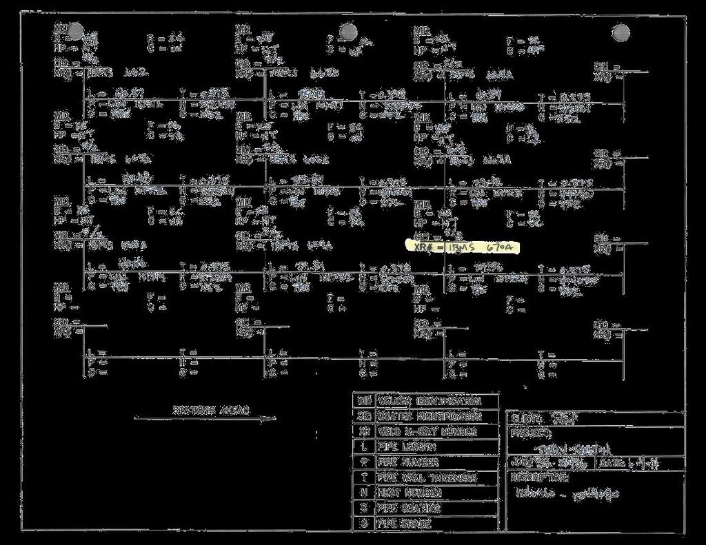
11 Pipeline Terminology (FERC) Federal Energy Regulatory Commission TALLY is the process of confirming the manufacturer - MANIFEST or MILL DATA PIPE is commonly known as a JOINT Joint Mapping is the process of recording the weld and joint data after the pipeline is welded together. Joint offcut is called a PUP ROW strictly speaking is legal ROW for pipeline CORRIDOR is combination of permanent & temporary easement area (area allowed to work within)

12 Why? Then & Now

13 Then?


14 Trimble R10 GPS Rover and TSC3 w/ Access Pipelines Trimble R10 GPS Receiver Trimble TSC3


15 ODOT VRS (Virtual Reference System) The Ohio Department of Transportation, Office of CADD and Mapping Services operates and maintains a network of 54 strategically located GPS Continuously Operating Reference Stations (CORS) in the State of Ohio Real Time Kinematic surveying Network RTK Horizontal mm ppm RMS ~ ppm Vertical mm ppm RMS ~ ppm

16 Trimble Access Pipelines Detailed Overview


17 Trimble Access Pipelines Main workflows Record & validate pipe inventory Record relationship between joints Survey welds, bends, etc. after installation, automatically linking all pipe attributes
18 Trimble Access Pipelines Benefits? Better data in field & from field Less processing away from job site Quicker deliverables to contractors Who benefits? Surveyors working on pipelines where asset information is required Field crews & office technicians Contractors
19 Trimble Access Pipelines Additional Features Streamline cover computations Ensure work within corridor Record entry & exit to exclusion zones Slope stationing Ahead & back stationing Compute deflection angles Compute crossing angles & separation
20 Pipe Alignment Defining Pipe alignment (.rxl) allows: Compute & record preliminary station & offset when measuring points Station & offset can be recorded with any measurement No need to use stakeout to measure points simply to compute station & offset Station & offset recorded to job as an attribute Recording as attribute requires Feature & Attribute Library with station & offset fields & configuration to specify which to use Station & offset values only as accurate as preliminary alignment

21 Corridor Pipe alignment combined with corridor left/right width can be used to define working corridor or inclusion zone an area you should work within Complex corridors are better defined by using Shapefile, DXF or LandXML polygon Warning is displayed a point is stored outside the corridor
22 Exclusion Zones Supported exclusion zone file types: Shape files Polygons DXF files Closed polylines LandXML files Parcel elements Warning appears when exclusion zone is entered Position is recorded when exclusion zone is entered or exited If point is stored in exclusion zone, a warning will appear asking if it s appropriate to store in exclusion zone
23 Exclusion Zones Exhibit
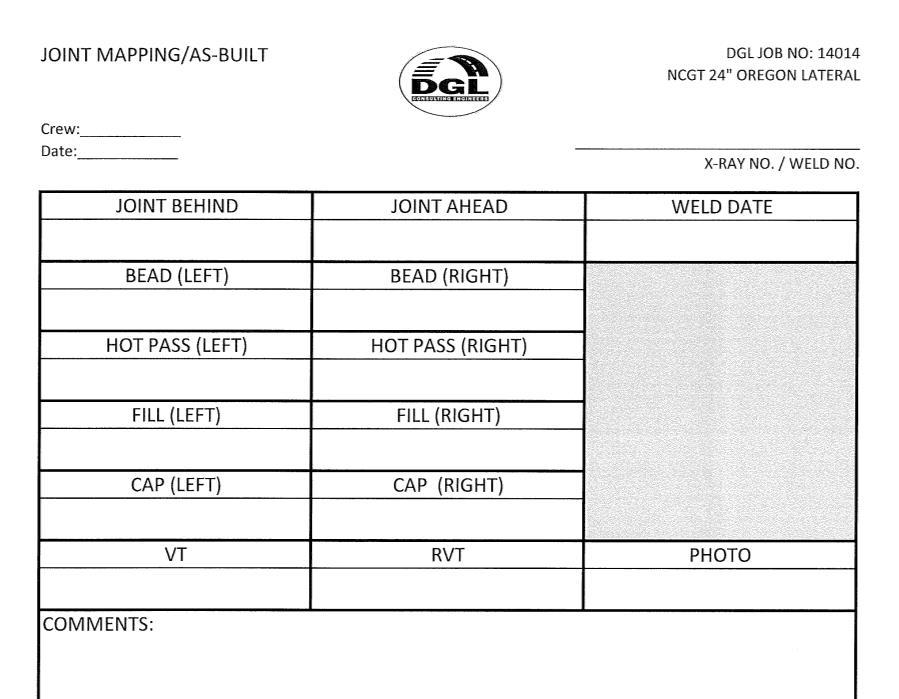
24 Data Collection Completely customizable Redundancy (both digital & hand written data)
25 Tally Getting started Get manifest from pipe manufacturer Modify the manifest as necessary to ensure unique ID & remove details not important (if you can t get a manifest, create a CSV with just a header containing attributes to be collected) Create or modify Feature code library (FXL) to match manifest/tally headings Copy Tally CSV & FXL to Controller Configure Job to link files

26 Yellow Fields Indicate Held Attribute


27

28 Tally Joint & Heat # s
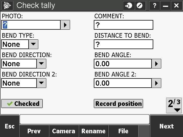
29 Check Tally

30 Ready for Joint Mapping

31 Joint Mapping Primary role of joint mapping is to record details of weld, bend or loose end & joint ahead & joint behind

32 Joint Mapping Data Welder s Stencil


33 Joint Mapping Office Setup


34 Joint Mapping Office Setup

35 Joint Mapping Field
36 Joint Mapping Bends Like welds, additional bend information can also be configured for storage Bend type; field or factory Direction 1; left, right, sag, overbend Angle 1 Direction 2 Angle 2 You configure the additional information to be stored

37 Field or Factory Bends

38 Collecting Additional Bend Information

39 As-Built Pipeline Diagram

40 Cut Out Welds Tap the cut-out icon then tap Update to remove from the joint map sequence If you cut-out a joint map weld you need to enter a new ID for replacement weld. If you Delete a joint map, you can reuse the ID.
41 PUPs The tally typically includes the joint length As shown in the previous slides, the tally is accessible for review & edit during joint mapping The tally is easily accessible during the survey of the welds Any time the joint length is shortened by more than a user-configured distance, you are prompted to create a PUP

42 PUP Creation The original length was 20m It was changed to 17m A dialog appears giving you the option to create a PUP
43 Automated Cover Computations Numerous ways to compute cover, simply because different projects/clients/surveyors have different needs Use solution that works best for you: From closest natural ground point From last measured point From vertical alignment From surface model
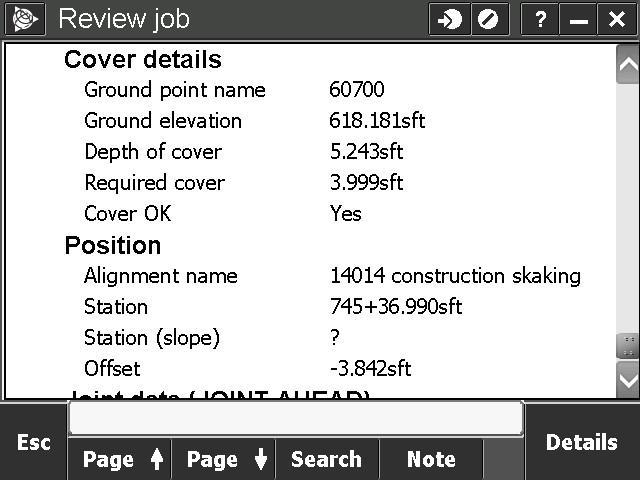
44 Cover Computations Data
45 Pipeline / Utility Crossings Surveying pipeline crossings is another important process most companies perform The Compute intersection angle function allows to calculate crossing details: Record angle of intersection Record separation Store intersection point Produce report on crossings
46 Export & Reporting All data, including weld & joint ID, joint attributes, cover, crossings calculations etc. are all stored in Trimble Access job Data flows through to TBC Reporting in Trimble Access can be used for daily reports Tally progress Joint mapping progress Crossing reports As-built progress
47 Deliverables / End Results Insert.kml file into Google Earth image with data link Export into Excel spread sheet Export into a Geodatabase

48 Google Earth Image with.kml File

49 Google Earth Image with.kml File

50 Deliverables / End Results


51 Deliverables / End Results

52 Deliverables / End Results
53 Deliverables / End Results

54 Deliverables / End Results
TRIMBLE ACCESS PIPELINES USER GUIDE
 TRIMBLE ACCESS PIPELINES USER GUIDE Version 2018.00 Revision A June 2018 Contents Introduction 4 Jobs, tallies and joint maps 5 Stakeout 9 Pipelines jobs 10 To configure Pipeline options 10 To link weld
TECHNICAL NOTES SURVEY PRO WITH TSX
 SURVEY PRO WITH TSX TECHNICAL NOTES Survey Pro software from TDS is the data collection solution of choice for most North American surveyors 1. And with the addition of the Trimble TSX (Trimble Systems
RELEASE NOTES. Trimble Access Software
 RELEASE NOTES Trimble Access Software Version 2015.21 Revision A September 2015 1 Legal Information Trimble Navigation Limited Engineering Construction Group 935 Stewart Drive Sunnyvale, California 94085
3-D MODELING FOR MACHINE CONTROL
 SHELLY & SANDS JOHN DOWALTER, PE, PS 3-D MODELING FOR MACHINE CONTROL Dale Carnegie Public Speaking Training Ben Stein s Public Speaking Training SHELLY & SANDS JOHN DOWALTER, PE, PS S&S Survey Manager
Trimble Business Center Software, v3.30
 Trimble Business Center Software, v3.30 We are pleased to announce a new version of the Trimble Business Center software, version 3.30. This new version includes over 30 new features and enhancements increasing
TRIMBLE ACCESS HELP SHEETS Using Map Functions
 1 of 5 SUPPORTED MAP FEATURES This section will guide the user through some Trimble Access Map funtions including: Importing surfaces, Alignments,.shp files,.dxf files; creating surfaces, creating lines
Overview September 7, 2017
 Overview September 7, 2017 Purpose The purpose of this presentation is to provide an overview of the changes to the required deliverables and workflow for developing plans and models for Illinois DOT projects
Trimble SCS900 Site Controller Software for Beginners. Jordan Lawver HCC-6339
 Trimble SCS900 Site Controller Software for Beginners Jordan Lawver HCC-6339 Agenda What is Trimble SCS900 Site Controller Software? Who uses SCS900 Trimble Site Positioning System software portfolio Applications
TECHNICAL NOTES TRIMBLE SURVEY CONTROLLER SOFTWARE
 TRIMBLE SURVEY CONTROLLER SOFTWARE TECHNICAL NOTES The Trimble Survey Controller software is the data collection solution that will make your survey work faster, easier, and more productive than ever before.
2/9/2016. Session Agenda: Implementing new Geospatial Technologies for more efficient data capture
 Implementing new Geospatial Technologies for more efficient data capture Jay Haskamp Applied Geospatial Engineer Steve Richter VP Sales Session Agenda: Today s changing technologies and what lies ahead
Trimble MX2 mobile mapping
 Trimble MX2 mobile mapping user applications Point clouds within your reach The Trimble MX2 is a vehicle-mounted spatial imaging system which combines high resolution laser scanning and panoramic cameras
RELEASE NOTES. Trimble Access Software
 RELEASE NOTES Trimble Access Software Version 2017.11 Revision A March 2018 1 Legal Information Trimble Inc. www.trimble.com Copyright and Trademarks 2009 2018, Trimble Inc. All rights reserved. Trimble,
General GPS TPS ROB X POLE VOL RDN RPL Jobs management System settings (units, precision, parameters, etc.)
") XPAD Survey Modules XPAD Survey GPS TPS XPOLE General GPS TPS ROB XPOLE VOL RDN RPL Jobs management System settings (units, precision, parameters, etc.) Instruments GPS GPS TPS ROB XPOLE VOL RDN RPL Instrument
XPAD Survey Modules XPAD Survey GPS TPS XPOLE General GPS TPS ROB XPOLE VOL RDN RPL Jobs management System settings (units, precision, parameters, etc.) Instruments GPS GPS TPS ROB XPOLE VOL RDN RPL Instrument
Licensed Features - Trimble Business Center v3.10
 Licensed Features - Trimble Business Center v3.10 The following table lists the features available in Trimble Business Center based on the installed. Feature No License Base Complete Advanced Photogrammetry
3-D Modeling Implementation
 3-D Modeling Implementation Presented January 31, 2013 Douglas Townes FHWA Resource Center WORKFLOW FOR ELECTRONIC DATA TRANSFER WHEN USING AMG IN CONSTRUCTION Charles Jahren, PhD Iowa State University
Processing Feature Codes SPECTRA PRECISION SURVEY OFFICE TUTORIAL
 Processing Feature Codes SPECTRA PRECISION SURVEY OFFICE TUTORIAL Corporate office: Spectra Precision 10355 Westmoor Drive Suite #100 Westminster, CO 80021 USA Phone: +1-720-587-4700 Toll free (in USA):
This document contains a list of all changes, new features, bug fixed introduced in this last version of X PAD Survey.
 News X PAD Survey - January 2014 X PAD Survey 2.5.5 This document contains a list of all changes, new features, bug fixed introduced in this last version of X PAD Survey. GPS X-Y RSM: X and Y RMS accuracy
technical notes Trimble survey controller field software
 Trimble survey controller field software technical notes For more than a decade, Trimble Survey Controller field software has provided land surveyors with a complete GNSS and optical data-collection solution
A New Dimension to Land Development and Subdivision Design: Application of AutoCAD Civil 3D
 A New Dimension to Land Development and Subdivision Design: Application of AutoCAD Civil 3D Tarig Ali College of Engineering and Computer Science University of Central Florida Orlando, Florida taali@mail.ucf.edu
Hamilton County Enhances GIS Base Mapping with 1-foot Contours
 Hamilton County Enhances GIS Base Mapping with 1-foot Contours Presented by Larry Stout, Hamilton County GIS Manager Brad Fugate, Woolpert Inc. Today s Presentation Hamilton County s 2004 Base Mapping
X PAD Construction 2.5.5
 News X PAD Construction January 2014 X PAD Construction 2.5.5 This document contains a list of all changes, new features, bug fixed introduced in this last version of X PAD Construction. GPS RTCM3.1: RTCM3.1
TRIMBLE BUSINESS CENTER
 TRIMBLE BUSINESS CENTER Release Notes Version 3.61 Geospatial Division, 10368 Westmoor Drive, Westminster, CO 80021, USA 2015, Trimble Navigation Limited. All rights reserved. Trimble, the Globe & Triangle
Airborne LiDAR Surveys and Data Delivery in the Pipeline Industry
 Airborne LiDAR Surveys and Data Delivery in the Pipeline Industry Carlos Femmer Faron Olivier October 25, 2011 October 25, 2011 GITA GIS for Oil and Gas Pipeline 2011 Organization Fugro is a decentralized
THE FUTURE OF STATE PLANE COORDINATES AT ODOT
 THE FUTURE OF STATE PLANE COORDINATES AT ODOT BY: RAY FOOS P.S. AND BRIAN MEADE P.S. THE OHIO DEPARTMENT OF TRANSPORTATION WORKING WITH STATE PLANE COORDINATES OR HOW TO MAKE THE EARTH FLAT SURVEYORS AND
Instrument Manual. Interface to Trimble Access (including Survey Controller)
") Instrument Manual Interface to Trimble Access (including Survey Controller) Contents Introduction... 3 Chapter 1 LSS install... 4 1.1 Install LSS, 3D Vision, Tutorials and Testdata... 4 1.2 Survey instrument
Instrument Manual Interface to Trimble Access (including Survey Controller) Contents Introduction... 3 Chapter 1 LSS install... 4 1.1 Install LSS, 3D Vision, Tutorials and Testdata... 4 1.2 Survey instrument
PUBLIC WORKS. 1oo. DiEital Fee Schedules. Effective January 1, 2008
 PUBLIC WORKS Geographic Information Systems DiEital Fee Schedules Effective January 1, 2008 Date Advertised 12103/07 In (Publication) Daily Business Journal Public Hearing Date Approved as to form: David
SURVRD for Existing Feature Models file in FDOTSS4 OpenRoads
 SURVRD for Existing Feature Models file in FDOTSS4 OpenRoads Production Support Office - CADD Chris Thorp What is a SURVRD file? SURVRD Survey Development Model for 3D Design It is a critical file for
Unmanned Aerial Systems: A Look Into UAS at ODOT
 Ohio Department of Transportation John R. Kasich, Governor Jerry Wray, Director Unmanned Aerial Systems: Tim Burkholder, PS Mapping Manager Division of Engineering Office of CADD and Mapping Services Kyle
Interface to icon Construction Instruments and Machine Control
 Interface to icon Construction Instruments and Machine Control CONTENTS 1. Preamble 2. Install and Configure LSS 3. Exporting data to Leica Machine Control (Scanlaser) 4. Importing LSS exported files into
Figure 1: Mobile mapping project location in New York City.
 Using Mobile LiDAR to Deliver Survey Accurate Data This presentation will take the attendees though the process of controlling and delivering survey grade LiDAR data for use in CADD, Modeling, and GIS
TxDOT Survey Manual. Manual Notice Archive. by Texas Department of Transportation (512) - all rights reserved
 - all rights reserved") TxDOT Survey Manual Manual Notice Archive by Texas Department of Transportation (512) - all rights reserved Manual Notice 2011-1 From: Manual: Judy Skeen, P. E., Director, Technology Services Division
TxDOT Survey Manual Manual Notice Archive by Texas Department of Transportation (512) - all rights reserved Manual Notice 2011-1 From: Manual: Judy Skeen, P. E., Director, Technology Services Division
RELEASE NOTES TRIMBLE ACCESS SOFTWARE
 RELEASE NOTES TRIMBLE ACCESS SOFTWARE Version 2014.20 Revision A October 2014 1 Legal Information Trimble Navigation Limited Engineering Construction Group 935 Stewart Drive Sunnyvale, California 94085
Pipeline engineer competency standards list: onshore sector
 Pipeline engineer competency standards list: onshore sector ID Competency area/competency Gen Des Cons Ops Level General engineering GE001 Engineering degree in a relevant discipline x Core GE002 Pipeline
Roadway Alignments and Profiles
 NOTES Module 15 Roadway Alignments and Profiles In this module, you learn how to create horizontal alignments, surface profiles, layout (design) profiles, and profile views in AutoCAD Civil 3D. This module
GETTING STARTED GUIDE
 GETTING STARTED GUIDE Trimble Variety Tracking System Introduction Getting the most out of the Trimble Variety Tracking system Preparing for installation Calibrating the system Recording varieties during
12d Model v8 interface to Trimble instruments 2007
 These notes describe the interfacing of 12d version 8 with the Trimble surveying instruments. 1) Installing Trimble link Trimble link must be installed prior to attempting to upload or download data to
Continuously Operating GPS Reference Network. Jim Waters, PE, RLS Assistant Director, Design Division
 Continuously Operating GPS Reference Network Jim Waters, PE, RLS Assistant Director, Design Division TDOT began discussions internally about a possible Continuously Operating Reference Network in 1999
TRIMBLE ACCESS TRIMBLE ACCESS PROJECTS AND JOBS GUIDE
 TRIMBLE ACCESS TRIMBLE ACCESS PROJECTS AND JOBS GUIDE Version 2018.10 Revision A August 2018 Contents Projects & jobs 3 Managing projects 6 To create a local project 7 File transfer 7 Trimble data folders
TRIMBLE ACCESS TRIMBLE ACCESS PROJECTS AND JOBS GUIDE
 TRIMBLE ACCESS TRIMBLE ACCESS PROJECTS AND JOBS GUIDE Version 2018.00 Revision A June 2018 Contents Projects & jobs 3 Managing projects 6 To create a local project 7 File transfer 8 Trimble data folders
Central Coast LIDAR Project, 2011 Delivery 1 QC Analysis LIDAR QC Report February 17 th, 2012
 O R E G O N D E P A R T M E N T O F G E O L O G Y A N D M I N E R A L I N D U S T R I E S OLC Central Coast Delivery 1 Acceptance Report. Department of Geology & Mineral Industries 800 NE Oregon St, Suite
What s new in Civil Designer 2015
 What s new in Civil Designer 2015 We have concentrated on adding in additional functionality requested by our extensive client base as well as optimising existing features. Survey & Terrain Significant
OCTOBER OTEC Session 75 Stringless 3D Paving
 OCTOBER 03 2018 OTEC Session 75 Stringless 3D Paving Introductions Brian E Girouard, Trimble Inc Sales Engineer Paving Specialist Manager brian_girouard@trimble.com Brad Cunningham, SITECH Ohio SITECH
Rogue River LIDAR Project, 2012 Delivery 1 QC Analysis LIDAR QC Report September 6 th, 2012
 O R E G O N D E P A R T M E N T O F G E O L O G Y A N D M I N E R A L I N D U S T R I E S OLC Rogue River Delivery 1 Acceptance Report. Department of Geology & Mineral Industries 800 NE Oregon St, Suite
Please print twice and give one to a friend. Here is an example of the Deed Plotter and All Topo Maps working together.
 JOHNSON MAPPING SOFTWARE & PLOTTING SEMINARS Mike Johnson, Seminar Author & Instructor, also Dealer for: Deed Plotter+for Windows (by Greenbrier Graphics)& the All Topo Maps (by igage Mapping Co.) Computer
DPS900 SOFTWARE QUICK REFERENCE CARD FOR PILING OPERATORS
 DPS900 SOFTWARE QUICK REFERENCE CARD FOR PILING OPERATORS This document contains information for piling operators on how to use the Trimble DPS900 software. For information for supervisors, please refer
The ODOT_XSLabeling.mvba application is used to draw basic labels on cross sections extracted from a Roadway Designer DTM file.
 Application Name: Current version: Required MicroStation Version: Required GEOPAK Version: ODOT_XSLabeling.mvba v11.07.15 XM or V8i XM or V8i The ODOT_XSLabeling.mvba application is used to draw basic
technical notes Trimble business CenTer software trimble BuSineSS Center your Complete office Solution
 Trimble business CenTer software technical notes trimble BuSineSS Center your Complete office Solution designed for today's fast-paced surveying office, trimble Business Center unlocks the potential of
Release Notes SPECTRA PRECISION SURVEY OFFICE. Versions 3.30 (64-bit)
") Release Notes SPECTRA PRECISION SURVEY OFFICE Versions 3.30 (64-bit) Corporate office: Spectra Precision 10368 Westmoor Drive Westminster, CO 80021 USA www.spectraprecision.com Copyright and trademarks:
Release Notes SPECTRA PRECISION SURVEY OFFICE Versions 3.30 (64-bit) Corporate office: Spectra Precision 10368 Westmoor Drive Westminster, CO 80021 USA www.spectraprecision.com Copyright and trademarks:
Carlson GIS for Surveyors
 Professional Land Surveyors of Ohio 2016 Annual Conference -- Dayton Ohio Carlson GIS for Surveyors Presented by Who Is That CAD Girl? Jennifer DiBona is a long time CAD consultant and trainer doing business
Release Notes TRIMBLE BUSINESS CENTER. Version 2.50
 Release Notes TRIMBLE BUSINESS CENTER Version 2.50 Corporate office: Trimble Navigation Limited Engineering and Construction Division 5475 Kellenburger Road Dayton, Ohio 45424-1099 USA Phone: +1-937-233-8921
Civil 3D Introduction
 Civil 3D Introduction Points Overview Points are data collected by surveyors which represent existing site conditions (elevations, boundaries, utilities, etc.). Each point is numbered (or named) and has
TcpMDT. Digital Terrain Model Version 7.5. TcpMDT
 Digital Terrain Model Version 7.5 Versions and Modules PROFESSIONAL STANDARD IMAGES SURVEYING POINT CLOUD Product Features STANDARD Surveying Points Management Digital Terrain Model Contours Terrain Cross
Application Description
 Application Name: ODOT_SheetManager.mvba Tested MicroStation Version: MicroStation V8i (SELECTseries 3) Tested GEOPAK/OpenRoads Version: Not Applicable Application Description The January 16, 2015 update
3D Modeling for Contractors
 3D Modeling for Contractors The Constructible Model Joel Brown SITECH Ohio a construction technology partner for the 21 st Century Major brand vendor Work with hundreds of Civil Contractors Sales Support
Perpendicular Offsets - point picker is a check-box type button and will now remain in effect until switched off.
 New Functionality Raw File Viewer This now has a View button that allows the user to see the map in a split view. Tapping on certain records will show up as icons in the view. For example tapping an OC
This document will cover some of the key features available only in SMS Advanced, including:
 Key Differences between SMS Basic and SMS Advanced SMS Advanced includes all of the same functionality as the SMS Basic Software as well as adding numerous tools that provide management solutions for multiple
RELEASE NOTES. Trimble Access Software
 RELEASE NOTES Trimble Access Software Version 2016.01 Revision A May 2016 1 Legal Information Trimble Navigation Limited Engineering Construction Group 935 Stewart Drive Sunnyvale, California 94085 U.S.A.
USER GUIDE. Trimble SCS900 software
 USER GUIDE Trimble SCS900 software Version 3.5.1 Revision A April 2016 1 Corporate Office Trimble Navigation Limited 935 Stewart Drive Sunnyvale, CA 94085 USA www.trimble.com Heavy Civil Construction Division
Forest Technology: Apps, Maps, Phones, and Drones
 Forest Technology: Apps, Maps, Phones, and Drones TFA Annual Meeting 2018 Darian Yawn LandMark Spatial Solutions, LLC Forest Technology Company Sales, Training, Support GIS Consulting, Repairs, Rentals
AutoCAD Civil-3D Nyheter AutoCAD Civil-3D 2013
 AutoCAD Civil-3D Nyheter AutoCAD Civil-3D 2013 Tesfaye Kebede Vianova systems New Features Civil-3D Pressure Pipe Network Volumes Dashboard Analysis Data Exchange Railway Design Corridor Design Survey
Qinertia THE NEXT GENERATION INS/GNSS POST-PROCESSING SOFTWARE. For all mobile surveying applications
 Qinertia THE NEXT GENERATION INS/GNSS POST-PROCESSING SOFTWARE For all mobile surveying applications Survey Efficiently, Survey Anywhere, Survey Serenely. QINERTIA has been designed to help surveyors get
Trimble Survey Controller. Release Notes
 Trimble Survey Controller Release Notes Version 7.70 Revision A January 2001 Corporate Office Trimble Navigation Limited Technical Publications Group 645 North Mary Avenue Post Office Box 3642 Sunnyvale,
City of La Crosse Online Mapping Website Help Document
 City of La Crosse Online Mapping Website Help Document This document was created to assist in using the new City of La Crosse online mapping sites. When the website is first opened, a map showing the City
Trimble Business Center
 Trimble Business Center Release Notes Version 3.90 www.trimble.com 2017, Trimble Inc. All rights reserved. Trimble and the Globe & Triangle logo are trademarks of Trimble Inc. registered in the United
Survey Pro Software. Includes Spectra Precision Central: Spectra Precision s cloud computing solution. Survey Pro: Simply The Best
 Survey Pro Software Includes Spectra Precision Central: Spectra Precision s cloud computing solution. Survey Pro: Simply The Best SURVEY PROSimplicity, Reliability, and Security Spectra Precision Ranger
Working With External Design Software
 Working With External Design Software Introduction This document describes methods for working with project data from external civil design packages such as Civil 3D, Bentley civil products, 12d Model
James Schneider Advanced Materials and Technology
 (CEC-90153) Minnesota DOT Deploy GCS900, Business Center HCE and VisionLink with the DOTs GEOPAK software to automatically monitor large scale excavation in Carver County James Schneider Advanced Materials
PV-ezDesign Introduction training for Residential project
 PV-ezDesign Introduction training for Residential project Residential draft Page 1 of 23 Open the following link to access your account: www.clenergy.com/pvezdesgin Residential draft Page 2 of 23 Create
Reference Manual. TopSURV OnBoard
 Reference Manual TopSURV OnBoard TOC Table of Contents What s New with TopSURV... ix Preface... xiii Terms and Conditions... xiii Manual Conventions... xv Introduction... 1-1 Title Bar... 1-2 Menu Bar...
Integrated Field to Finish BIM for Surveyors. Boris Skopljak Market Manager, Trimble Geospatial Office Software
 Integrated Field to Finish BIM for Surveyors Boris Skopljak (boris_skopljak@trimble.com) Market Manager, Trimble Geospatial Office Software Agenda Trimble Introduction BIM relevance in Trimble Trimble
IESVE Plug-in for Trimble SketchUp Version 3 User Guide
 IES Virtual Environment Copyright 2015 Integrated Environmental Solutions Limited. All rights reserved. No part of the manual is to be copied or reproduced in any form without the express agreement of
Sandy River, OR Bathymetric Lidar Project, 2012 Delivery QC Analysis Lidar QC Report March 26 th, 2013
 O R E G O N D E P A R T M E N T O F G E O L O G Y A N D M I N E R A L I N D U S T R I E S OLC Sandy River, OR Bathymetric Lidar Project Delivery Acceptance Report. Department of Geology & Mineral Industries
technical notes trimble business center software
 technical notes trimble business center software A POWERFUL SURVEY DATA OFFICE SOFTWARE SUITE DESIGNED FOR TODAY'S FAST-PACED SURVEYING OFFICE, TRIMBLE BUSINESS CENTER SOFTWARE UNLOCKS THE POTENTIAL OF
Merging Geospatial Technologies to Improve the Bottom Line. John Whitehead Trimble Navigation Limited
 Merging Geospatial Technologies to Improve the Bottom Line John Whitehead Trimble Navigation Limited Trimble: Data Collection to Decision Making Today s Survey Professional Today s Customer Requirements
SurvCE: Localizations
 SurvCE: Localizations Mark Silver Electrical Engineer, not a Surveyor Carlson Dealer in Salt Lake City Utah Embarrassing Fact: I have a 250,000+ sheet paper map collection. igage Mapping Corporation www.igage.com
Burns, OR LIDAR Project, 2011 Delivery QC Analysis LIDAR QC Report February 13th, 2012
 O R E G O N D E P A R T M E N T O F G E O L O G Y A N D M I N E R A L I N D U S T R I E S OLC Burns, OR Delivery Acceptance Report. Department of Geology & Mineral Industries 800 NE Oregon St, Suite 965
QUICK START GUIDE. SOLO Forest
 QUICK START GUIDE SOLO Forest Software Installation 1. For PC installation, run the.msi file. 2. For Mobile device installation, copy the.cab file onto the device 3. Run the.cab file Starting the Program
Do More. Change the world in 3D. AutoCAD. Civil 3d
 Do More. Change the world in 3D. AutoCAD Civil 3d 2010 A Powerful Building Information Modeling Solution for Civil Engineering AutoCAD Civil 3D software supports an integrated process focused on a coordinated
Texas Transportation Institute The Texas A&M University System College Station, Texas
 1. Report No. FHWA/TX-08/5-2110-01-4 4. Title and Subtitle INVENTORY OF UTILITIES SUMMARY REPORT 2. Government Accession No. 3. Recipient's Catalog No. Technical Report Documentation Page 5. Report Date
Disaster Mitigation Projects in Polis. December 14, 2016
 1 Disaster Mitigation Projects in Polis December 14, 2016 Briefing Agenda 2 About Polis Multi s Mitigation Planning Flood s s Disaster Mitigation Platforms Consultancies Training Discussion 3 About us
ADDENDUM TO APRIL 2003 MANUAL 1. INTRODUCTION 1 2. GIS PROGRAMS 1 3. IMPORTING AND EXPORTING GIS FILES 2 4. IMPORTING ESRI FILES 3
 DRAINS ADDENDUM TO APRIL 2003 MANUAL 29 May 2003 CONTENTS 1. INTRODUCTION 1 2. GIS PROGRAMS 1 3. IMPORTING AND EXPORTING GIS FILES 2 4. IMPORTING ESRI FILES 3 5. EXPORTING ESRI FILES 9 6. IMPORTING MAPINFO
Manitowoc County, WI Advanced Access GIS Viewer User Documentation
 Manitowoc County, WI Advanced Access GIS Viewer User Documentation Introduction Extensive time was put into developing this website both from a display, and from a printing and scaling perspective. This
Midstream GIS in Barnett Managing Data, Delivering Quality. Jan Van Sickle, PLS, PhD Downtown Design Services Inc
 Midstream GIS in Barnett Managing Data, Delivering Quality Jan Van Sickle, PLS, PhD Downtown Design Services Inc GIS, Geomatic Engineering and Remote Sensing are terms that have been in use for decades
Making ArcGIS Work for You. Elizabeth Cook USDA-NRCS GIS Specialist Columbia, MO
 Making ArcGIS Work for You Elizabeth Cook USDA-NRCS GIS Specialist Columbia, MO 1 Topics Using ArcMap beyond the Toolkit buttons GIS data formats Attributes and what you can do with them Calculating Acres
DASHBOARD OPERATION MANUAL. Machine Control, Inc.
 DASHBOARD OPERATION MANUAL Machine Control, Inc. INTEGRATE YOUR DATA With highly accurate topographic data describing your job site, its easy to envision and design a multiphase system to address your
Release Notes SPECTRA PRECISION SURVEY OFFICE. Version
 Release Notes SPECTRA PRECISION SURVEY OFFICE Version 3.90.1 Corporate office: Spectra Precision 10368 Westmoor Drive Westminster, CO 80021 USA www.spectraprecision.com Copyright and trademarks: 2005-2017,
Highway Performance Monitoring System
 Highway Performance Monitoring System Version 1.0 June 2011 Quick Start Guide for Version 8.0 Federal Highway Administration Table of Contents Chapter 1 Introduction... 1 Chapter 2 HPMS Workflow... 2 Chapter
Site calibration improvements for GPS operations. Stakeout line changes. Call API toll free (888)
") Welcome to the Q4 Edition of the API Newsletter. This newsletter is being presented as an information tool to present new product information. If there are any questions regarding any products or services
Welcome to the Q4 Edition of the API Newsletter. This newsletter is being presented as an information tool to present new product information. If there are any questions regarding any products or services
technical notes Trimble survey Manager Software
 Trimble survey Manager Software technical notes Powerful field and office software for the acquisition, processing, and display of precise real-time surveys. Never has the integration of survey data from
Table of Contents 1 PURPOSE SCOPE DEFINITIONS PROCEDURE... 5
 Table of Contents 1 PURPOSE... 3 2 SCOPE... 3 3 DEFINITIONS... 4 4 PROCEDURE... 5 4.1 Overview - Performing a Site Calibration... 5 4.1.1 Upload Mine Grid Control... 6 4.1.2 Obtain SSM Data... 7 4.1.3
Trimble s RoadLink Utility Tutorials
 Trimble s RoadLink utility is an interface between third-party road definitions and Trimble survey devices. It lets you import or key in road definitions, view them graphically, edit them if required,
5/17/2017. Steven Popke, PE Wisconsin DOT Bureau of Project Development Methods Development Unit
 Steven Popke, PE Wisconsin DOT Bureau of Project Development Unit Wisconsin Department of Transportation since 2014 Assists with WisDOT spilot program for sharing design model data with construction contractors
Linus L. Smith, GIS Supervisor, Engineering Public Works Department, City of Winfield, Kansas
 Challenges in Developing a City GIS Wastewater Geo Database System Linus L. Smith, GIS Supervisor, Engineering Public Works Department, City of Winfield, Kansas OVERVIEW The City of Winfield Kansas recognized
2009 IHEEP CONFERENCE The Future of CORS Networks and AMG
 2009 IHEEP CONFERENCE The Future of CORS Networks and AMG Background Dominick Izzo, PE Lancaster Development, Inc. Heavy Highway Contractor in Upstate NY Member of NYSAGC/NYSDOT Emerging Technology Committee
User s guide December 2011
 User s guide User s guide December 2011 WARNINGS In writing this manual every care has been taken to offer the most updated, correct and clear information possible; however unwanted errors are always
GASWorkS Product Description
 GASWorkS v10 Description: 1 GASWorkS Product Description GASWorkS has continued to evolve since our first quite simple but effective version of the software was released in 1991. Our latest release sports
Civil 3-D PROFILE CREATION
 Civil 3-D PROFILE CREATION 1 Alignment Overview: As in previous CAD versions, an alignment is a line that describes where you intend the centerline of your planned work to be. That s all. But, in Civil
Fusing LiDAR and Imagery: Providing Effective Solutions for Ohio s s Transportation Infrastructure
 Fusing LiDAR and Imagery: Providing Effective Solutions for Ohio s s Transportation Infrastructure Dave Blackstone GIS Manager Ohio Department of Transportation Brian Stevens, CP Project Manager Woolpert
REFERENCE. Section 6. Field Use Tutorial 2-1
 REFERENCE Section 6 Field Use Tutorial 2-1 REFERENCE 2-2 Field Use Overview RTK GPS support is an additional feature in Sitework 4D, which must be purchased separately. In addition to creating takeoffs
Lessons Learned from Implementing an Enterprise GIS solution for Cross-Country Pipeline Routing
 Lessons Learned from Implementing an Enterprise GIS solution for Cross-Country Pipeline Routing Jackie Smith, Williams Wetherbee Dorshow, Earth Analytic, Inc April 27, 2016 2013 The Williams Companies,