2009 IHEEP CONFERENCE The Future of CORS Networks and AMG
|
|
|
- Shona Cobb
- 6 years ago
- Views:
Transcription


1 2009 IHEEP CONFERENCE The Future of CORS Networks and AMG
2 Background Dominick Izzo, PE Lancaster Development, Inc. Heavy Highway Contractor in Upstate NY Member of NYSAGC/NYSDOT Emerging Technology Committee Contractor Advisor to AASHTO TIG on AMG
3 Tools for Automated Machine Guidance GPS Base Stations - +/-.1 ft Dozers Excavators Rollers Scrapers Laser Guided Systems - +/-.03 ft LPS (Local Positioning System) Dozers Grader Paving


4 Use of GPS for Machine Control Conventional GPS Base Stations Building Mount Post Mount Tripod
5 CORS Continuously Operating GPS Reference Stations Real Time GPS Data
6 What is CORS CORS is a network of GPS Base Stations coordinated by the National Geodetic Survey The CORS system enables positioning accuracies that approach a few centimeters relative to the National Spatial Reference System, both horizontally and vertically The GPS reference data used for post processing is typically acquired via direct download from the Internet

7 CORS Locations
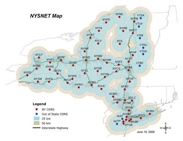
8 NYSNet
9 NYSNET
10 NYSNet
11 Data Accuracy NYSNet Accuracy is dependent upon equipment and procedures NYSDOT recommends testing the accuracy of all RTN product at each project site Testing should include connections to local coordinate system and datum
12 Data Reliability NYSNet The NYSNet RTN is dependent upon a real time data stream through the NYSDOT IT network If the network connection to a particular site is down, the RTK processing software can deliver data from the nearest site
13 NYSNet Reference Station Datums NYSDOT CORS positions are based on the North American Datum of 1983, CORS adjustment NAD83(CORS96)(EPOCH ) Users must determine appropriate connections to local coordinate systems NYSDOT CORS are not directly connected to the North American Vertical Datum of 1988(NAVD88) Users must determine appropriate connections to local datums
14 Uses of CORS in Construction Traditional Use of CORS by NYSDOT Survey and Stakeout Preconstruction Survey for Design Post Construction Survey
15 Expand Role of CORS in Construction Construction Project Ideal to CORS Use Project with minimal earthwork Includes utility work Bridge Construction Layout AUTOMATED MACHINE GUIDANCE
16 Expanded Role of CORS in Construction NYSDOT Project D Albany County $37,000,000 Single Point Urban Interchange (SPUI) SPUI on top of the replacement bridge 4 reconfigured ramps New Acceleration and deceleration lanes on Interstate 87 Remote location Wetland Mitigation
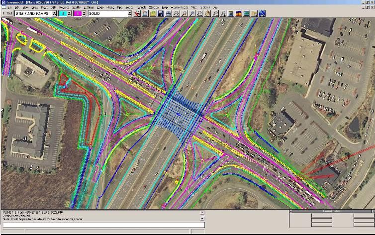
17 D260830
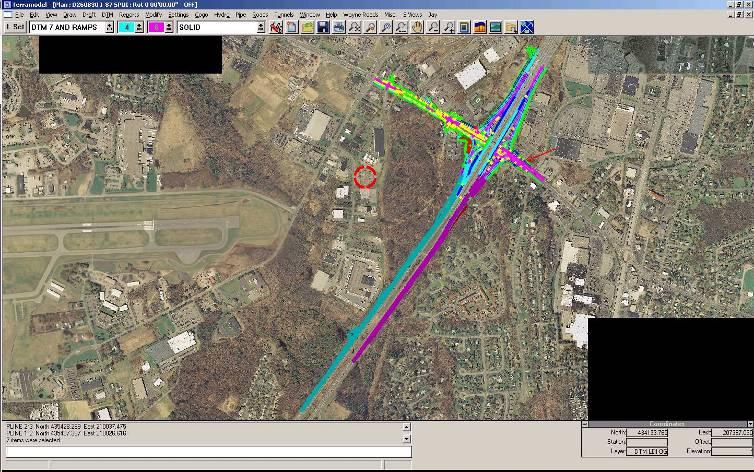
18 D260830
19 Implementation of CORS for AMG Equipment Needed Consulted with NYSDOT and Trimble Modem Computer Radio and Antenna Possible 2 nd Radio to use as a repeater Rovers Survey (Contractor and NYSDOT) AMG Equipment

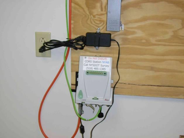
20 Modem, Computer, and Radio
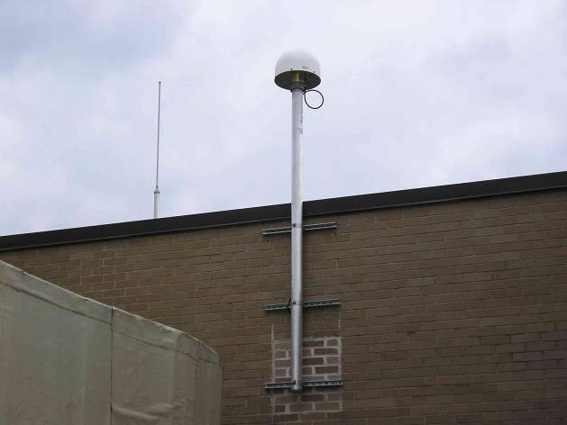
21 Antenna
22 Use of CORS on D Developed Contract Control Plan Used Base Station as a companion for start of project Calibrated Site with CORS and RTK GPS Base Station to the same points Same model used for both CORS and RTK Base Station Use Robotic Total Station to be used for Bridge components and as Specification required in other work
23 CORS Vs. RTK Base Tested GPS (survey) accuracy Tested Range of GPS signal Tested availability of radio signal Tested range of radio signal
24 CORS Vs. RTK Base Issues GPS (Survey) Accuracy was consistent with RTK Range of GPS signal was consistent with RTK Availability of Radio signal from CORS was and still is inconsistent 65 outages from April 1 st to September 1st

25 CORS Vs. RTK Base Issues Radio Signal Strength with CORS was 65% of RTK Base

26 Use of Repeater Radio

27 CORS Range with Repeater

28 AMG in Use
29 Improvement of Radio Signal Communication difficulties between NYSNet and radio in field office Possible error in signal due to NYSDOT IT Firewall Possible connection through NYSDOT field office to the Radio would eliminate firewall interference
30 Improvement of Radio Signal (con t) Use of cell modem on equipment or rovers Range limited by cell reception
31 Other Options for AMG Use of Virtual Reference Stations (VRS) Difference between CORS and VRS CORS requires post processing for centimeter processing VRS is a RTK solution
32 Advantage of CORS and VRS No need for base station Survey crews and equipment security is increased No limit to number of rovers Range depends on radio equipment
33 Acknowledgements NYSDOT Trimble FHWA AASHTO TIG for AMG
34 QUESTIONS?
James Schneider Advanced Materials and Technology
 (CEC-90153) Minnesota DOT Deploy GCS900, Business Center HCE and VisionLink with the DOTs GEOPAK software to automatically monitor large scale excavation in Carver County James Schneider Advanced Materials
3-D MODELING FOR MACHINE CONTROL
 SHELLY & SANDS JOHN DOWALTER, PE, PS 3-D MODELING FOR MACHINE CONTROL Dale Carnegie Public Speaking Training Ben Stein s Public Speaking Training SHELLY & SANDS JOHN DOWALTER, PE, PS S&S Survey Manager
Continuously Operating GPS Reference Network. Jim Waters, PE, RLS Assistant Director, Design Division
 Continuously Operating GPS Reference Network Jim Waters, PE, RLS Assistant Director, Design Division TDOT began discussions internally about a possible Continuously Operating Reference Network in 1999
TxDOT Survey Manual. Manual Notice Archive. by Texas Department of Transportation (512) - all rights reserved
 - all rights reserved") TxDOT Survey Manual Manual Notice Archive by Texas Department of Transportation (512) - all rights reserved Manual Notice 2011-1 From: Manual: Judy Skeen, P. E., Director, Technology Services Division
TxDOT Survey Manual Manual Notice Archive by Texas Department of Transportation (512) - all rights reserved Manual Notice 2011-1 From: Manual: Judy Skeen, P. E., Director, Technology Services Division
Positioning NYSNet with. The National Spatial Reference System (NSRS)
") Positioning NYSNet with The National Spatial Reference System (NSRS) January 2017 1 Positioning NYSNet 2 1) National Spatial Reference System (NSRS) 5 Minutes NGS CORS NGS Guidelines for RTN s 2) Positioning
Positioning NYSNet with The National Spatial Reference System (NSRS) January 2017 1 Positioning NYSNet 2 1) National Spatial Reference System (NSRS) 5 Minutes NGS CORS NGS Guidelines for RTN s 2) Positioning
Trimble Site EASY-TO-USE RELIABLE ACCURATE
 Trimble Site Positioning Systems ACCURATE RELIABLE EASY-TO-USE more tools for more jobs Estimators Bid Team Site Surveyor Data Manager Site Engineer/Grade Checker Site Foreman/Supervisor Project Manager
Delivering 3D Engineered Model Data for Highway Construction
 Delivering 3D Engineered Model Data for Highway Construction Objectives After completing this module, you will be able to: Describe how 3D engineered models are created in design Describe how contractors
DTFH61-13-C Addressing Challenges for Automation in Highway Construction
 DTFH61-13-C-00026 Addressing Challenges for Automation in Highway Construction Learning Objectives Research Objectives Research Team Introduce Part I: Implementation Challenges and Success Stories Describe
Interactive Augmented Reality Visualization for Improved Damage Prevention and Maintenance of Underground Infrastructure
 Interactive Augmented Reality Visualization for Improved Damage Prevention and Maintenance of Underground Infrastructure Amir H. Behzadan 1, and Vineet R. Kamat 2 1 Assistant Professor, Department of Construction
Which Trimble Grade Control System for which application?
 September 2005 Which Trimble Grade Control System for which application? The following outlines the ideal and typical applications for each of the Trimble Grade Control Systems. The information has been
CORS networks today and tomorrow latest improvements and applications
 CORS networks today and tomorrow latest improvements and applications Dennis KILIAN, Germany Trimble Germany GmbH, Am Prime Parc 11, Raunheim, Germany Keywords: GNSS, Global Navigation Satellite System,
Setup a VSN Survey Style Using Trimble Access (Bluetooth Phone)
") Setup a VSN Survey Style Using Trimble Access (Bluetooth Phone) California Surveying & Drafting Supply Technical Support Services Notes: This tutorial is designed as a tutorial for users with a cell phone/vsn
Setup a VSN Survey Style Using Trimble Access (Bluetooth Phone) California Surveying & Drafting Supply Technical Support Services Notes: This tutorial is designed as a tutorial for users with a cell phone/vsn
OCTOBER OTEC Session 75 Stringless 3D Paving
 OCTOBER 03 2018 OTEC Session 75 Stringless 3D Paving Introductions Brian E Girouard, Trimble Inc Sales Engineer Paving Specialist Manager brian_girouard@trimble.com Brad Cunningham, SITECH Ohio SITECH
Central Coast LIDAR Project, 2011 Delivery 1 QC Analysis LIDAR QC Report February 17 th, 2012
 O R E G O N D E P A R T M E N T O F G E O L O G Y A N D M I N E R A L I N D U S T R I E S OLC Central Coast Delivery 1 Acceptance Report. Department of Geology & Mineral Industries 800 NE Oregon St, Suite
TECHNICAL NOTES SURVEY PRO WITH TSX
 SURVEY PRO WITH TSX TECHNICAL NOTES Survey Pro software from TDS is the data collection solution of choice for most North American surveyors 1. And with the addition of the Trimble TSX (Trimble Systems
Wisconsin Height Modernization Program (WI-HMP) and Continuously Operating Reference Stations (CORS)
 and Continuously Operating Reference Stations (CORS)") Wisconsin Height Modernization Program (WI-HMP) and Continuously Operating Reference Stations (CORS) Improving the Vertical Component of the Geodetic Network California Spatial Reference Center San Jose,
Wisconsin Height Modernization Program (WI-HMP) and Continuously Operating Reference Stations (CORS) Improving the Vertical Component of the Geodetic Network California Spatial Reference Center San Jose,
TECHNICAL NOTES TRIMBLE SURVEY CONTROLLER SOFTWARE
 TRIMBLE SURVEY CONTROLLER SOFTWARE TECHNICAL NOTES The Trimble Survey Controller software is the data collection solution that will make your survey work faster, easier, and more productive than ever before.
Sandy River, OR Bathymetric Lidar Project, 2012 Delivery QC Analysis Lidar QC Report March 26 th, 2013
 O R E G O N D E P A R T M E N T O F G E O L O G Y A N D M I N E R A L I N D U S T R I E S OLC Sandy River, OR Bathymetric Lidar Project Delivery Acceptance Report. Department of Geology & Mineral Industries
TechnicalNotes. Trimble Total Control Software
 TechnicalNotes Trimble Total Control Software POWERFUL GEODETIC CONTROL FOR ALL SURVEY PROJECTS A survey is only as good as its control elements. Trimble Total Control software puts you in total control
Table of Contents 1 PURPOSE SCOPE DEFINITIONS PROCEDURE... 5
 Table of Contents 1 PURPOSE... 3 2 SCOPE... 3 3 DEFINITIONS... 4 4 PROCEDURE... 5 4.1 Overview - Performing a Site Calibration... 5 4.1.1 Upload Mine Grid Control... 6 4.1.2 Obtain SSM Data... 7 4.1.3
3-D Modeling Implementation
 3-D Modeling Implementation Presented January 31, 2013 Douglas Townes FHWA Resource Center WORKFLOW FOR ELECTRONIC DATA TRANSFER WHEN USING AMG IN CONSTRUCTION Charles Jahren, PhD Iowa State University
Advanced Use of Automatic Grade Controls. Jeroen Snoeck Segment Manager Paving Trimble Navigation Ltd.
 Advanced Use of Automatic Grade Controls Jeroen Snoeck Segment Manager Paving Trimble Navigation Ltd. Contents Industry trends driving technology in Heavy & Highway Construction Traditional Grade Control
GIS Mapping of Pipelines
 GIS Mapping of Pipelines RJ Lumbrezer, PS Survey Manager DGL Consulting Engineers, LLC Ted Muns Sales Manager City Blueprint of Toledo 2016 Ohio GIS Conference Hyatt Regency Columbus September 28 30, 2016
Session Objectives. Describe how 3D Models are created during design. Discuss what 3D Model outputs are useful in Construction
 1 Session Objectives Describe how 3D Models are created during design Discuss what 3D Model outputs are useful in Construction Describe applications of 3D Models in Construction 2 Creating the 3D Design
Landfill Grading Using GPS Machine Control
 Landfill Grading Using GPS Machine Control NC SWANA April 2018 Presented by: Bernie Garrett, PE Garrett & Moore Inc. & Gabe Leach Cooper Barnette & Page Inc. 1 Purpose Work flow processes used by Engineers,
Trimble Business Center Software, v3.30
 Trimble Business Center Software, v3.30 We are pleased to announce a new version of the Trimble Business Center software, version 3.30. This new version includes over 30 new features and enhancements increasing
3D System. 2D & 3D Systems. Compact Attachments
 3D System 2D & 3D Systems 1 2D System 2D System Systems work off a single plain Flat Single slope Dual Slope Bobcat laser system is 2D 2 Sonic 3 3D System 3D System Works off elevation coordinates setup
Trimble Grade Control Systems GCS900 2D for Excavators
 GCS900 2D for Excavators Trimble offers the heavy and highway contractor the broadest range of Grade Control Systems in the industry. From 2D depth, slope, and elevation based to 3D GNSS or Total Station
OLC Wasco County: Delivery One.
 OLC Wasco County: Delivery One www.quantumspatial.com January 2, 2014 Trimble R7 Receiver set up over GPS monument WASCO_02. Data collected for: Oregon Department of Geology and Mineral Industries 800
Paul DiGiacobbe, PE, DBIA MASER Consulting Ryan Putt, PE HNTB Corporation Kevin Poad, PE HNTB Corporation
 Paul DiGiacobbe, PE, DBIA MASER Consulting Ryan Putt, PE HNTB Corporation Kevin Poad, PE HNTB Corporation Introduction Using LiDAR to Manage Safety Assets SPEED the acquisition phase is being performed
GCS900 GRADE CONTROL SySTEmS LK Bu RADE G FINISH
 GCS900 GRADE CONTROL Systems BulK Grade take the guesswork out of earthworks Trimble sets the standard for construction technology by developing highly productive, integrated and innovative solutions for
SITECH INTERMOUNTAIN YOUR CONSTRUCTION TECHNOLOGY PROVIDER
 SITECH INTERMOUNTAIN YOUR CONSTRUCTION TECHNOLOGY PROVIDER SITECH Intermountain is established in Utah and Nevada as well as in several adjacent counties in Wyoming, Arizona and California and joins the
Site calibration improvements for GPS operations. Stakeout line changes. Call API toll free (888)
") Welcome to the Q4 Edition of the API Newsletter. This newsletter is being presented as an information tool to present new product information. If there are any questions regarding any products or services
Welcome to the Q4 Edition of the API Newsletter. This newsletter is being presented as an information tool to present new product information. If there are any questions regarding any products or services
Presentation Overview
 Stringless Concrete Paving STRINGLESS CONCRETE PAVING ACPA BUS TOUR AUGUST 5, 2015 Presentation Overview 1) Manufactures 2) Components needed for Stringless Paving 3) Conventional Methods VS Stringless
Trimble Survey Controller. Release Notes
 Trimble Survey Controller Release Notes Version 10.5 Revision A September 2002 Corporate Office Trimble Navigation Limited Engineering and Construction Division 5475 Kellenburger Road Dayton, Ohio 45424-1099
Philip J. Meis, M.S., P.E., M.ASCE Chair
 Establishing ASCE Standard Consensus Activity for Utility As-Built Records Philip J. Meis, M.S., P.E., M.ASCE Chair Utility As-Built Standard Overview Background and Need Scope Committee Members Schedule
Trimble SCS900 Site Controller Software for Beginners. Jordan Lawver HCC-6339
 Trimble SCS900 Site Controller Software for Beginners Jordan Lawver HCC-6339 Agenda What is Trimble SCS900 Site Controller Software? Who uses SCS900 Trimble Site Positioning System software portfolio Applications
Surveying. Session GPS Surveying 1. GPS Surveying. Carrier-Phase (RTK) Pseudo-Range (DGPS) Slide 1
 Pseudo-Range (DGPS) Slide 1") GPS Surveying Slide 1 GPS Surveying Surveying Mapping Standalone Relative Relative Standalone Post-Processed Real-Time Static / Fast Static Kinematic Stop & Go Rapid-Static Carrier-Phase (RTK) Pseudo-Range
GPS Surveying Slide 1 GPS Surveying Surveying Mapping Standalone Relative Relative Standalone Post-Processed Real-Time Static / Fast Static Kinematic Stop & Go Rapid-Static Carrier-Phase (RTK) Pseudo-Range
CORSnet-NSW: Towards State-wide CORS Infrastructure for NSW, Australia
 CORSnet-NSW: Towards State-wide CORS Infrastructure for NSW, Australia Volker Janssen, Adrian White and Thomas Yan Dr Volker Janssen GNSS Surveyor (CORS Network) Survey Infrastructure and Geodesy NSW Land
2017 OLC Silver Creek
 2017 OLC Silver Creek December 15, 2017 www.quantumspatial.com Data collected for: Oregon Department of Geology and Mineral Industries 800 NE Oregon Street Suite 965 Portland, OR 97232 Prepared by: Quantum
MaCORS Quick Guide. Rover Configuration for Topcon GR 3 using Carlson SurvCE 2.x & Internal CDMA Modem
 MaCORS Quick Guide Rover Configuration for Topcon GR 3 using Carlson SurvCE 2.x & Internal CDMA Modem This Quick Guide outlines configuring the Topcon GR 3 with Carlson SurvCE & Internal CDMA modem to
Template for CORS Networks
 Template for CORS Networks This template gives an idea on what can be included in the document or poster to describe the national or regional CORs network that your organisation is responsible for. The
Use Veta to analyze the data for coverage uniformity and intelligent compaction measurement values.
 Replace section 30-6 with: 30-6.01 PAVEMENT RECYCLING WITH INTELLIGENT COMPACTION 30-6.01A GENERAL 30-6.01A(1) Summary Section 30-6 includes specifications for compaction of cold in-place recycling (CIR)
trimble gnss surveying systems
 trimble gnss surveying systems TRIMBLE GNSS SYSTEMS: SOLVING YOUR CHALLENGES IN THE FIELD INDUSTRY-LEADING GNSS SOLUTIONS DESIGNED WITH THE SURVEYOR IN MIND Backed by a legacy of GNSS technology surveying
Trimble Dredge Navigation and Management Solutions
 Trimble Dredge Navigation and Management Solutions November 2018 Trimble Dredge Navigation and Management Solutions UPG (Ultimate Positioning Group) and SITECH Construction Systems are Australia s premier
LEICA MobileMatriX Equipment List
 LEICA MobileMatriX LEICA MobileMatriX software 742117 GSW450, LEICA MobileMatriX License. Single user license for Standard Edition. ESRI ArcView OEM. Protected. COGO computation and rendering of COGO measurements
Rogue River LIDAR Project, 2012 Delivery 1 QC Analysis LIDAR QC Report September 6 th, 2012
 O R E G O N D E P A R T M E N T O F G E O L O G Y A N D M I N E R A L I N D U S T R I E S OLC Rogue River Delivery 1 Acceptance Report. Department of Geology & Mineral Industries 800 NE Oregon St, Suite
2017 OLC Siskiyou. September 27,
 2017 OLC Siskiyou September 27, 2017 www.quantumspatial.com Data collected for: Oregon Department of Geology and Mineral Industries 800 NE Oregon Street Suite 965 Portland, OR 97232 Prepared by: Quantum
CONFIRMATION OF VERTICAL SURVEY CONTROL IN THE BIRDS POINT-NEW MADRID FLOODWAY Final Report 10/27/2015
 Reply to Attention of: DEPARTMENT OF THE ARMY MEMPHIS DISTRICT CORPS OF ENGINEERS 167 NORTH MAINSTREET B-202 MEMPHIS, TENNESSEE 38103-1894 CONFIRMATION OF VERTICAL SURVEY CONTROL IN THE BIRDS POINT-NEW
Advanced Highway Maintenance and Construction Technology Research Center
 Advanced Highway Maintenance and Construction Technology Research Center Department of Mechanical and Aerospace Engineering University of California at Davis Creating Standards and Specifications for the
technical notes Trimble survey controller field software
 Trimble survey controller field software technical notes For more than a decade, Trimble Survey Controller field software has provided land surveyors with a complete GNSS and optical data-collection solution
APS-3 with Seismic Surveyor
 APS-3 with Seismic Surveyor Configuration Manual Revision 1.01 Page 1 APS-3 with Seismic Surveyor, Configuration Manual 2011 ALTUS Positioning Systems Inc. All rights reserved. ALTUS, the ALTUS logo, and
Qinertia THE NEXT GENERATION INS/GNSS POST-PROCESSING SOFTWARE. For all mobile surveying applications
 Qinertia THE NEXT GENERATION INS/GNSS POST-PROCESSING SOFTWARE For all mobile surveying applications Survey Efficiently, Survey Anywhere, Survey Serenely. QINERTIA has been designed to help surveyors get
TRIMBLE GPS SEARCH TECHNOLOGY FOR THE PROFESSIONAL SURVEYOR
 TRIMBLE GPS SEARCH TECHNOLOGY FOR THE PROFESSIONAL SURVEYOR BY TIM LEMMON AND CHRIS VAN DER LOO, TRIMBLE APPLICATIONS SPECIALISTS, WESTMINSTER, COLORADO, U.S.A. ABSTRACT The Global Positioning System (GPS)
Box Calibration: Here I entered points 3 and 4 which are the only control points given to us in the plans.
 Box Calibration: Trimble machine control does not like files that are derived from State Plane Coordinates or files that contain a Geoid. Trimble representatives want everyone to do a site calibration
3D Technology in the Construction Continuum. Alabama DOT Pre-Construction Conference Montgomery AL May 03, 2016
 3D Technology in the Construction Continuum Alabama DOT Pre-Construction Conference Montgomery AL May 03, 2016 Brian E Girouard, Sales Engineer, Milling-Paving-Compaction Specialist Civil Engineering &
ROCKY FORK TRACT: VIEWSHED ANALYSIS REPORT
 ROCKY FORK TRACT: VIEWSHED ANALYSIS REPORT Prepared for: The Conservation Fund Prepared by: A Carroll GIS 3711 Skylark Trail Chattanoga, TN 37416 INTRODUCTION This report documents methods and results
WAN Failover Configuration for Palo Alto PA Series 6310-DX
 WAN Failover Configuration for Palo Alto PA Series 6310-DX Overview Integrating cellular Internet access into a traditional, wireline data network is typically accomplished through one of three interfaces:
Improving Quality Control with Intelligent Compaction
 2011 Ohio Paving & NCAUPG Conference Improving Quality Control with Intelligent Compaction Bob Horan, P.E. Asphalt Institute Regional Engineer Richmond VA Washington DC 1907 Intelligent Hauling Units?
ENHANCED DELIVERABLES AND THE DIGITAL JOBSITE NOVEMBER 14, 2018
 ENHANCED DELIVERABLES AND THE DIGITAL JOBSITE NOVEMBER 14, 2018 Background CP Tech Center/Snyder & Associates team EDC-2 3D Engineered Models EDC-4 e-construction (Digital Construction Inspection) 2 What
Setup a VSN Survey Style Using Trimble Access (MiFi Card)
") Setup a VSN Survey Style Using Trimble Access (MiFi Card) California Surveying & Drafting Supply Technical Support Services Notes: This tutorial is designed for users with a MiFi Card/VSN Setup. In order
Setup a VSN Survey Style Using Trimble Access (MiFi Card) California Surveying & Drafting Supply Technical Support Services Notes: This tutorial is designed for users with a MiFi Card/VSN Setup. In order
Vehicle Safety Communications Project Final Overview
 CAMP IVI Light Vehicle Enabling Research Program Vehicle Safety Communications Project Final Overview Vehicle Safety Communications (VSC) Project 2.5 year program started in May 2002 VSC Consortium Members:
Trimble Productivity: Finish Faster with Fewer Machines. TRIMBLE GCS900 GRADE CONTROL SYSTEMS
 Trimble Productivity: Finish Faster with Fewer Machines. TRIMBLE GCS900 GRADE CONTROL SYSTEMS TAKE ThE GUESSWORK OUT OF EARThWORKS. ONLY FROM ThE LEADER. TRIMbLE. The Connected Construction Site An interesting
Burns, OR LIDAR Project, 2011 Delivery QC Analysis LIDAR QC Report February 13th, 2012
 O R E G O N D E P A R T M E N T O F G E O L O G Y A N D M I N E R A L I N D U S T R I E S OLC Burns, OR Delivery Acceptance Report. Department of Geology & Mineral Industries 800 NE Oregon St, Suite 965
Geospatial GNSS Systems TRANSFORMING THE WAY THE WORLD WORKS
 Geospatial GNSS Systems GNSS Solutions Designed with the Surveyor in Mind POWERFUL TECHNOLOGY YOU CAN DEPEND ON NO MATTER WHAT THE CHALLENGE Whether you are climbing over rough terrain to collect topographic
3D Milling. Tom Abell
 3D Milling Tom Abell Trimble & 3D Milling as Part of the Resurfacing Process Design Measure Resurfacing From initial survey to finish surface Mill Compact Pave Content Data acquisition Creating data models
Trimble Grade Control Systems GCS900 2D for Dozers
 GCS900 2D for Dozers Trimble offers the heavy and highway contractor the broadest range of Grade Control Systems in the industry. From 2D depth, slope, and elevation based to 3D GNSS or Total Station based,
Trimble Grade Control Systems GCS900 2D for Excavators
 GCS900 2D for Excavators Trimble offers the heavy and highway contractor the broadest range of Grade Control in the industry. From 2D depth, slope, and elevation-based to 3D GNSS or Total Station-based,
Grade Control. GRADE CONTROL SYSTEMS Topcon. MOTOR GRADER 3D-GPS+, mmgps Plug-and-Play. HYDRAULIC EXCAVATOR X63 3D-GPS+ Plug-and-Play
 GRADE CONTROL SYSTEMS Topcon Grade Control CRAWLER DOZER 3D-MC 2 Plug-and-Play HYDRAULIC EXCAVATOR X63 3D-GPS+ Plug-and-Play MOTOR GRADER 3D-GPS+, mmgps Plug-and-Play PHOTOS MAY INCLUDE OPTIONAL EQUIPMENT
RAILWAY PROJECT Geodetic Reference System, Geodetic Control Network and Rail Construction Measurements
 RAILWAY PROJECT Geodetic Reference System, Geodetic Control Network and Rail Construction Measurements Railway Project 2 / 8 INDEX 1 Introduction... 3 2 Reference System... 3 2.1 Reference system... 3
APS-3 with FieldGenius Configuration Manual
 APS-3 with FieldGenius Configuration Manual Version 1.3 Table of contents 1 Getting Started... 2 1.1 Hardware requirements... 2 1.2 Installing FIELDGenius... 2 2 Septentrio FIELDGenius Startup... 3 2.1
Iowa Department of Transportation Office of Design. Photogrammetric Mapping Specifications
 Iowa Department of Transportation Office of Design Photogrammetric Mapping Specifications March 2015 1 Purpose of Manual These Specifications for Photogrammetric Mapping define the standards and general
Cross Slope Collection using Mobile Lidar
 Cross Slope Collection using Mobile Lidar ACEC/SCDOT Annual Meeting December 2, 2015 Introduction Adequate cross slopes on South Carolina Interstates result in: Proper drainage Enhance driver safety by
Texas Transportation Institute The Texas A&M University System College Station, Texas
 1. Report No. FHWA/TX-08/5-2110-01-4 4. Title and Subtitle INVENTORY OF UTILITIES SUMMARY REPORT 2. Government Accession No. 3. Recipient's Catalog No. Technical Report Documentation Page 5. Report Date
BLM Fire Project, 2013 QC Analysis Lidar and Orthophoto QC Report November 25th, 2013
 O R E G O N D E P A R T M E N T O F G E O L O G Y 1937 A N D M I N E R A L I N D U S T R I E S Department of Geology & Mineral Industries 800 NE Oregon St, Suite 965 Portland, OR 97232 BLM Fire Project,
FieldGenius 2010 Release Notes
 FieldGenius 2010 Release Notes This document contains the release notes for all FieldGenius 2010 releases. The latest release notes can be found at the end of the document. FieldGenius 2010 4.2.0 (Released
Overview September 7, 2017
 Overview September 7, 2017 Purpose The purpose of this presentation is to provide an overview of the changes to the required deliverables and workflow for developing plans and models for Illinois DOT projects
Evidence Recorder Release Notes
 Evidence Recorder 7.1.0 Release Notes Released on: August 20, 2010 Important Notes We will be dropping support for several older builds of Evidence Recorder including: Allegro CE, Toughbook, Recon.Net,
USER GUIDE. Trimble SCS900 software
 USER GUIDE Trimble SCS900 software Version 3.5.1 Revision A April 2016 1 Corporate Office Trimble Navigation Limited 935 Stewart Drive Sunnyvale, CA 94085 USA www.trimble.com Heavy Civil Construction Division
W D-0049/004 EN
 September 21, 2011 Contact Ground Survey Report, Lidar Accuracy Report, & Project Report New Madrid Seismic Zone Northeast of Memphis, Tennessee Contract Number: W91278-09D-0049/004 EN Project: C-10-026
OPTIMIZING 3D SURFACE CHARACTERISTICS DATA COLLECTION BY RE-USING THE DATA FOR PROJECT LEVEL ROAD DESIGN
 OPTIMIZING 3D SURFACE CHARACTERISTICS DATA COLLECTION BY RE-USING THE DATA FOR PROJECT LEVEL ROAD DESIGN Benoit Petitclerc, P.E. John Laurent, M. Sc Richard Habel, M. Sc., Pavemetrics Systems Inc., Canada
Enterprise GIS. GIS Data Collection Standards. and. Geospatial Data Standards. August, 2017
 Enterprise GIS GIS Data Collection Standards and Geospatial Data Standards August, 2017 1 Contents Section 1 1.1 GIS Data Collection Standards 1.2 GPS/GNSS Data Collection and Delivery Standards 1.3 Field
Georeferencing West Virginia DOT s Roadside Assets: An Asset Inventory Case Study. Geoff Dew April 13,
 : An Asset Inventory Case Study Geoff Dew April 13, 2010 General Project Scope 17,817 miles collected across all systems. System Type Delivered Miles 1 Interstates 1100.820 2 US Routes 2184.538 3 WV Routes
North Carolina Geodetic Survey. North Carolina Continuous Operating Reference Stations (CORS)
") North Carolina Geodetic Survey North Carolina Continuous Operating Reference Stations (CORS) What is a CORS? Continuously Operating Reference Station (CORS) o A permanent Global Navigation Satellite System
North Carolina Geodetic Survey North Carolina Continuous Operating Reference Stations (CORS) What is a CORS? Continuously Operating Reference Station (CORS) o A permanent Global Navigation Satellite System
ENHANCED PARKWAY STUDY: PHASE 3 REFINED MLT INTERSECTION ANALYSIS
 ENHANCED PARKWAY STUDY: PHASE 3 REFINED MLT INTERSECTION ANALYSIS Final Report Prepared for Maricopa County Department of Transportation Prepared by TABLE OF CONTENTS Page EXECUTIVE SUMMARY ES-1 STUDY
Developing a National Real-time CORS Network in New Zealand. Presentation to XXIV FIG International Congress 2010, Sydney, Australia, 15 April 2010
 PositioNZ-RT Developing a National Real-time CORS Network in New Zealand Dave Collett Geodetic Surveyor Land Information New Zealand Presentation to XXIV FIG International Congress 2010, Sydney, Australia,
3DMC Reference Guide
 P O S I T I O N I N G S Y S T E M S 3DMC Reference Guide Part Number 7010-0911 Rev. C Copyright Topcon Positioning Systems, Inc. September, 2010 All contents in this manual are copyrighted by Topcon. All
Sokkia GSR 2700 ISX GPRS Configuration
 Sokkia GSR 2700 ISX GPRS Configuration You must be using FieldGenius 2008 v4.0.1 or newer. Start Settings Coordinate System Coordinate System Settings Access this screen by going to Start Settings Coordinate
Trimble GCSFlex Grade Control System For Excavators
 The Trimble GCSFlex Grade Control System is an easy-to-use, reliable, and affordable machine control system to improve excavator productivity and be more competitive. The system provides real-time grade
Impact of Satellite Positioning Services on State Survey Control Networks
 Impact of Satellite Positioning Services on State Survey Control Networks Dr. Stefan Willgalis Ingenieurbüro für Geodäsie und Geoinformation Hanover, Germany XXIII International FIG Congress Munich, 09.10.2006
Qinertia THE NEXT GENERATION INS/GNSS POST-PROCESSING SOFTWARE. For all mobile surveying applications
 Qinertia THE NEXT GENERATION /GNSS POST-PROCESSING SOFTWARE For all mobile surveying applications Survey Efficiently, Survey Anywhere, Survey Serenely. QINERTIA has been designed to help surveyors get
Introduction of Nikon Trimble
 Technical Seminar Reference Frame in Practice, Introduction of Nikon Trimble Sponsors: Page 1 Nikon Trimble - Joint Venture company Established 1917 1978 Products High Quality Optical and Imaging GNSS,
Topcon GRS-1 1 Receiver Field Preparation
 Topcon GRS-1 1 Receiver Field Preparation What do you need to know to get started with your Topcon GRS-1? Topcon GRS-1 Receiver - Field Preparation Some Common Questions Which TopSURV modules do I buy?
Business Advantages of Using Electronic Engineering Data
 Business Advantages of Using Electronic Engineering Data Dan Streett, PE & LS NYS Department of Transportation December 5, 2006 AGC/DOT Technical Conference Types of Electronic Engineering Data Created
RELEASE NOTES. Trimble Access Software
 RELEASE NOTES Trimble Access Software Version 2017.11 Revision A March 2018 1 Legal Information Trimble Inc. www.trimble.com Copyright and Trademarks 2009 2018, Trimble Inc. All rights reserved. Trimble,
MISSISSIPPI AND ALABAMA COASTAL MAPPING
 LIDAR REPORT MISSISSIPPI AND ALABAMA COASTAL MAPPING U.S. ARMY CORPS OF ENGINEERS MOBILE DISTRICT CONTRACTOR: R&M CONSULTANTS, INC. CONTRACT NO. W91278-04-D-0001/0003 EN PROJECT NO. C-05-054 Prepared By:
VECTOR. Vermont Enhanced CORS and Transmission Of Real-time Corrections. Network Status and Current Applications
 VECTOR Vermont Enhanced CORS and Transmission Of Real-time Corrections Network Status and Current Applications Daniel J. Martin, National Geodetic Survey Bill Kules, Little River Survey Ron Tabor, Vermont
INDONESIA S GEOSPATIAL DATA INFRASTRUCTURE
 INDONESIA S GEOSPATIAL DATA INFRASTRUCTURE Antonius B. Wijanarto Head of Center for Geodetic Control Network and Geodynamics GEOSPATIAL INFORMATION AGENCY srgi@big.go.id ONE GEO.REFERENCE (One Map Policy)
TcpGPS. User Manual. Installation. The steps below must be followed:
 TcpGPS User Manual Installation The steps below must be followed: 1. Decompress the file TcpGPSSetup.zip. 2. Execute the file vcredist_x86_vs2008.exe. This application will install the libraries required
trimble gnss surveying systems
 trimble gnss surveying systems TRIMBLE GNSS SYSTEMS: SOLVING YOUR CHALLENGES IN THE FIELD INDUSTRY-LEADING GNSS SOLUTIONS DESIGNED WITH THE SURVEYOR IN MIND Backed by a legacy of GNSS technology surveying