James Schneider Advanced Materials and Technology
|
|
|
- Eugenia Wiggins
- 5 years ago
- Views:
Transcription
1 (CEC-90153) Minnesota DOT Deploy GCS900, Business Center HCE and VisionLink with the DOTs GEOPAK software to automatically monitor large scale excavation in Carver County James Schneider Advanced Materials and Technology

2 Project Details

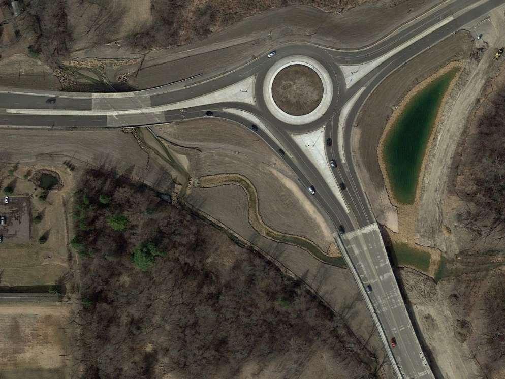
3 Project Details (CSAH 61/101 Reconstruction) Flood Mitigation Project Repeat Flooding last 20-years Minimal number of River Crossings Project Description Bridge Floodplain north of Minnesota River Channel 4-Lane 4,225-ft long 41 total spans 2 Roundabouts Bike Lane
 Muck Excavation 20 to 35 feet 350,000 cy of")

4 Project Details (Cont.) Muck Excavation 20 to 35 feet 350,000 cy of muck 510,000 cy excavation Water Table 5 ft below surface Automated Machine Guidance Excavation Added through Special Provisions

5 Soil Borings


6 Project Extents Before and After Before After

7


8


9
10 Special Provision Highlights Automated Machine Guidance - Excavation
11 Description S-37.1 The Contractor will use an Automated Machine Guidance (AMG) System for collection and recording of GNSS coordinates for creation of a 3D model reflecting the muck excavation bottom.

12 Equipment Requirements S-37.3.A.2 Instrumented with the following: Ability to connect to: RTK-GPS Local, ground-based base station, and/or MnDOT MnCORS-VRS Network Total Station Onboard Documentation System


13 Equipment Requirements Data Transfer S-37.3.A.2 Modem, or Wi-Fi for transferring data to cloud storage and mapping.

14 Equipment Requirements: Submersible Enclosures S-37.3.A.2.E Submersible enclosures for sensors may be needed. The Department anticipates that there will be locations with standing water.


15 Cloud Storage and Cloud Computing S-37.3.A.5 Provide user ID / passwords to Department Duration of Access Prior to start of excavation efforts requiring AMG-Excavation until 90 days after final acceptance per MnDOT
16 Cloud Computing and Mapping S-37.3.A.4 Mesh Size after Post Processing 24 in (600 mm) in X, Y, Z direction Filter Abilities Current, Lowest, Highest Elevations (filter and map) Time/Date Location/Project Extents Import and Export Surface (3D) Models in *.TTM/LandXML format Import corridor (background) designs Including station-based alignment data
 County Coordinates NAD83 (adjustment as specified by Department) NAVD88 Vertical Datum Indicate cutting edge of")
17 Automated Machine Guidance Data S-37.3.A.3 Coordinates XYZ Accuracy 0.2 ft (5 cm) County Coordinates NAD83 (adjustment as specified by Department) NAVD88 Vertical Datum Indicate cutting edge of the excavation equipment Data Collection Interval Continuous
 X, Y, & Z 0.")
18 Department Approval of System for Use (cont.) S-37.3.D.4 Calibration of GNSS Accuracy 10 locations, at least 2 ft (600 mm) apart Different boom stick and buck orientations Mark location next to bucket Collect and compare GNSS coordinates AMG system vs. Independent Device (Rover) X, Y, & Z 0.33 ft (100 mm)
19 System Failure S-37.3.E.5 System Failure Excavation equipment becomes inoperable and/or AMG system does not collect and/or store data per requirements of contract Contact the Department Start/End of System Failure Grace Period Resolved by beginning of next day of excavation req. AMG-Excavation Conventional Survey Methods Supervision of Licensed Land Surveyor or Plan approved by Dept.
 at all muck excavation locations.")
20 Automatic Mapping Control (Mapping / Recording) S-37.3.E Use the AMG-Excavation system (GCS900 Grade Control System) at all muck excavation locations. Department GNSS Checks GNSS checks at discretion of the Department. X, Y, & Z 0.33 ft (100 mm)

21 Material Visual Verification Layer 1 Silty Clay, with Sand, Slightly Organic, Grey, Fine Alluvium Layer 2 Clayed Sand, Some Gravel, Grey, Coarse Alluvium Layer 3 Clayed Sand, Lots of Gravel, Mottled, Light Brown, Coarse Alluvium 1 2 3
22 Trimble GSC 900 Grade Control System for Excavators, TCC, VL- Legacy, Business Center - HCE
 Body Sensor (pitch & roll of machine) UTS / GNSS Antennas AS450 AS450 AS460")
 CB460 Onboard machine display Figure Courtesy")
23 Trimble GCS900 for Excavators Stick Sensor (orientation vectors) Boom Sensor (boom vectors) Body Sensor (pitch & roll of machine) UTS / GNSS Antennas AS450 AS450 AS460 MT900 - or - MS992 Radio (900 mhz) SNR - and- SNM940 On-Machine Modem AS455 Submersible Enclosure Bucket Sensor (Curl / Curl Out) CB460 Onboard machine display Figure Courtesy of Trimble


24 Caterpillar 374D Fitted With Dual GNSS Receivers

25 CB460 In-Cab Display and Graphics 3D Excavator Lightbar Guidance View Area Optional Text Area Guidance Settings Status Bar Cellular Signal Strength Mapping/ Recording Icon

 Bottom of Muck")
26 Internal Lightbar Scale Above bottom of muck At Design (estimated bottom of muck using soil borings) Bottom of Muck Below bottom of muck

27 Example Text View - GNSS Checks


28 Internal Storage Data Flow Cloud Storage: Trimble Connected Community Cloud Computing / Mapping: Trimble Vision Link Legacy Trimble Business Center - HCE Filter by Lowest Elevation
29 General Filter Settings for Surface File Export Elevation Type: Lowest Project extents dates for the limits of each excavation area 1 st Day of Excavation for given area to Current Date Ensure lowest elevation is captured and exported for volume calculations.
30 Excavation Details


31 GNSS Checks


32 Holes in Bucket


33 Video: Rolling Surcharge using Dozer


34 Mixing of Materials


35 High Water Table


36 Hauling Volumes

37 Trimble Vision Link Legacy: Real-Time Review

38 Trimble Business Center

39 Trimble Business Center: Depth Color Scale

40 Bottom of Muck Surface


41 Beginning Stages Muck not Removed

42 Improved Excavation Process

43 Video: Bottom of Muck Surface in Trimble Business Center

44 Overlaying Surfaces for Volume Calculations

45 Trimble Business Center Earthwork Volume Report

46 Trimble Business Center Earthwork Volume Report

47 Video: GEOPAK Volume Calculation
48 Software Comparison
49 Volume Report QUANTITY IS THE TOTAL CUT ONLY (NOT THE BALANCE)
50 Lessons Learned Running Total Excavate to a Design Turn Software off when not in use to eliminate unwanted data and keep the surface model clean
51 Benefits of AMG Excavation Method Increased Safety. No need to DTM excavated surface Visual representation of excavation Ability to obtain an excavated bottom surface in areas difficult to survey (under water) Surface created for accurate volume calculations No need to establish boundary for excavation Real-time tracking by all personnel Ability to obtain a more dense and accurate DTM vs. conventional survey methods Time and resource savings
52 Cons of AMG-Excavation Method Need an experienced operator to dig to a design verses digging a hole Initial cost and calibration Data service required to obtain real-time results Backup method needed when system is down.
53 Questions?
Trimble GCSFlex Grade Control System For Excavators
 The Trimble GCSFlex Grade Control System is an easy-to-use, reliable, and affordable machine control system to improve excavator productivity and be more competitive. The system provides real-time grade
2009 IHEEP CONFERENCE The Future of CORS Networks and AMG
 2009 IHEEP CONFERENCE The Future of CORS Networks and AMG Background Dominick Izzo, PE Lancaster Development, Inc. Heavy Highway Contractor in Upstate NY Member of NYSAGC/NYSDOT Emerging Technology Committee
Trimble Grade Control Systems GCS900 2D for Excavators
 GCS900 2D for Excavators Trimble offers the heavy and highway contractor the broadest range of Grade Control Systems in the industry. From 2D depth, slope, and elevation based to 3D GNSS or Total Station
Trimble Grade Control Systems GCS900 2D for Excavators
 GCS900 2D for Excavators Trimble offers the heavy and highway contractor the broadest range of Grade Control in the industry. From 2D depth, slope, and elevation-based to 3D GNSS or Total Station-based,
Trimble Grade Control Systems GCS900 2D for Dozers
 GCS900 2D for Dozers Trimble offers the heavy and highway contractor the broadest range of Grade Control Systems in the industry. From 2D depth, slope, and elevation based to 3D GNSS or Total Station based,
3-D MODELING FOR MACHINE CONTROL
 SHELLY & SANDS JOHN DOWALTER, PE, PS 3-D MODELING FOR MACHINE CONTROL Dale Carnegie Public Speaking Training Ben Stein s Public Speaking Training SHELLY & SANDS JOHN DOWALTER, PE, PS S&S Survey Manager
Trimble Grade Control Systems GCS900 2D for Motor Graders
 GCS900 2D for Motor Graders Trimble offers the heavy and highway contractor the broadest range of Grade Control Systems in the industry. From 2D laser or sonic based to 3D GNSS or Total Station based,
OCTOBER OTEC Session 75 Stringless 3D Paving
 OCTOBER 03 2018 OTEC Session 75 Stringless 3D Paving Introductions Brian E Girouard, Trimble Inc Sales Engineer Paving Specialist Manager brian_girouard@trimble.com Brad Cunningham, SITECH Ohio SITECH
DPS900 SOFTWARE QUICK REFERENCE CARD FOR PILING OPERATORS
 DPS900 SOFTWARE QUICK REFERENCE CARD FOR PILING OPERATORS This document contains information for piling operators on how to use the Trimble DPS900 software. For information for supervisors, please refer
Trimble Productivity: Finish Faster with Fewer Machines. GCS600 Grade Control System
 Trimble Productivity: Finish Faster with Fewer Machines GCS600 Grade Control System for Excavators Flexible, Affordable and Easy to Use Productivity and Payback in One Package: Looking for a flexible,
Delivering 3D Engineered Model Data for Highway Construction
 Delivering 3D Engineered Model Data for Highway Construction Objectives After completing this module, you will be able to: Describe how 3D engineered models are created in design Describe how contractors
3D Milling. Tom Abell
 3D Milling Tom Abell Trimble & 3D Milling as Part of the Resurfacing Process Design Measure Resurfacing From initial survey to finish surface Mill Compact Pave Content Data acquisition Creating data models
3-D Modeling Implementation
 3-D Modeling Implementation Presented January 31, 2013 Douglas Townes FHWA Resource Center WORKFLOW FOR ELECTRONIC DATA TRANSFER WHEN USING AMG IN CONSTRUCTION Charles Jahren, PhD Iowa State University
Trimble SCS900 Site Controller Software for Beginners. Jordan Lawver HCC-6339
 Trimble SCS900 Site Controller Software for Beginners Jordan Lawver HCC-6339 Agenda What is Trimble SCS900 Site Controller Software? Who uses SCS900 Trimble Site Positioning System software portfolio Applications
3D Modeling for Contractors
 3D Modeling for Contractors The Constructible Model Joel Brown SITECH Ohio a construction technology partner for the 21 st Century Major brand vendor Work with hundreds of Civil Contractors Sales Support
GCS900 GRADE CONTROL SySTEmS LK Bu RADE G FINISH
 GCS900 GRADE CONTROL Systems BulK Grade take the guesswork out of earthworks Trimble sets the standard for construction technology by developing highly productive, integrated and innovative solutions for
Setup a VSN Survey Style Using Trimble Access (MiFi Card)
") Setup a VSN Survey Style Using Trimble Access (MiFi Card) California Surveying & Drafting Supply Technical Support Services Notes: This tutorial is designed for users with a MiFi Card/VSN Setup. In order
Setup a VSN Survey Style Using Trimble Access (MiFi Card) California Surveying & Drafting Supply Technical Support Services Notes: This tutorial is designed for users with a MiFi Card/VSN Setup. In order
Trimble Grade Control Systems GCS900 2D for Motor Graders
 GCS900 2D for Motor Trimble offers the heavy and highway contractor the broadest range of Grade Control in the industry. From 2D laser or sonic based to 3D GNSS or Total Station based, Trimble systems
Setup a VSN Survey Style Using Trimble Access (Bluetooth Phone)
") Setup a VSN Survey Style Using Trimble Access (Bluetooth Phone) California Surveying & Drafting Supply Technical Support Services Notes: This tutorial is designed as a tutorial for users with a cell phone/vsn
Setup a VSN Survey Style Using Trimble Access (Bluetooth Phone) California Surveying & Drafting Supply Technical Support Services Notes: This tutorial is designed as a tutorial for users with a cell phone/vsn
3DMC / 3DXi Create a network equipment configuration. 2. Enter IP address & NTRIP information.
 3DMC / 3DXi 6.11.03 1. Added Network & Modem Support Added support for Wavecom and SmallTouch modems. Added RTCM 3.0 support Improvements made connecting to GPS networks. Network setup example: 1. Create
MoDOT s 3D Design Implementation, Electronic Deliverables, and E-Construction. Ashley Buechter, P.E. MoDOT CADD Support Engineer
 MoDOT s 3D Design Implementation, Electronic Deliverables, and E-Construction Ashley Buechter, P.E. MoDOT CADD Support Engineer LADOTD Transportation Conference February 29, 2016 General Information and
Presentation Overview
 Stringless Concrete Paving STRINGLESS CONCRETE PAVING ACPA BUS TOUR AUGUST 5, 2015 Presentation Overview 1) Manufactures 2) Components needed for Stringless Paving 3) Conventional Methods VS Stringless
Trimble VISION Positions from Pictures
 Trimble VISION Positions from Pictures This session will cover What Is Trimble VISION? Trimble VISION Portfolio What Do you Need? How Does It Work & How Accurate Is It? Applications Resources Trimble VISION
Title: Improving Your InRoads DTM. Mats Dahlberg Consultant Civil
 Title: Improving Your InRoads DTM Mats Dahlberg Consultant Civil Improving Your InRoads Digital Terrain Model (DTM) Digital Terrain Model A digital representation of a surface topography or terrain composed
Overview September 7, 2017
 Overview September 7, 2017 Purpose The purpose of this presentation is to provide an overview of the changes to the required deliverables and workflow for developing plans and models for Illinois DOT projects
USER GUIDE. Trimble SCS900 software
 USER GUIDE Trimble SCS900 software Version 3.5.1 Revision A April 2016 1 Corporate Office Trimble Navigation Limited 935 Stewart Drive Sunnyvale, CA 94085 USA www.trimble.com Heavy Civil Construction Division
Session Objectives. Describe how 3D Models are created during design. Discuss what 3D Model outputs are useful in Construction
 1 Session Objectives Describe how 3D Models are created during design Discuss what 3D Model outputs are useful in Construction Describe applications of 3D Models in Construction 2 Creating the 3D Design
TRIMBLE WESTMINSTER BUILDING PROJECT / 2013
 TRIMBLE WESTMINSTER BUILDING PROJECT - 2012 / 2013 OVERVIEW Outgrowing its current office facility in Westminster, Colorado, Trimble decided to build a larger campus across the street from their current
Box Calibration: Here I entered points 3 and 4 which are the only control points given to us in the plans.
 Box Calibration: Trimble machine control does not like files that are derived from State Plane Coordinates or files that contain a Geoid. Trimble representatives want everyone to do a site calibration
Table of Contents 1 PURPOSE SCOPE DEFINITIONS PROCEDURE... 5
 Table of Contents 1 PURPOSE... 3 2 SCOPE... 3 3 DEFINITIONS... 4 4 PROCEDURE... 5 4.1 Overview - Performing a Site Calibration... 5 4.1.1 Upload Mine Grid Control... 6 4.1.2 Obtain SSM Data... 7 4.1.3
trimble r10 GNSS System
 TRIMBLE R10 SERIES RECEIVER QUICK START GUIDE trimble r10 GNSS System C Warning: For safety information, refer to the Safety Information section of the Trimble R10 GNSS Receiver User Guide. Five simple
Continuously Operating GPS Reference Network. Jim Waters, PE, RLS Assistant Director, Design Division
 Continuously Operating GPS Reference Network Jim Waters, PE, RLS Assistant Director, Design Division TDOT began discussions internally about a possible Continuously Operating Reference Network in 1999
DTFH61-13-C Addressing Challenges for Automation in Highway Construction
 DTFH61-13-C-00026 Addressing Challenges for Automation in Highway Construction Learning Objectives Research Objectives Research Team Introduce Part I: Implementation Challenges and Success Stories Describe
Workshops funded by the Minnesota Environment and Natural Resources Trust Fund
 Workshops funded by the Minnesota Environment and Natural Resources Trust Fund Conservation Applications of LiDAR Data Workshops funded by: Minnesota Environment and Natural Resources Trust Fund Presented
Qinertia THE NEXT GENERATION INS/GNSS POST-PROCESSING SOFTWARE. For all mobile surveying applications
 Qinertia THE NEXT GENERATION /GNSS POST-PROCESSING SOFTWARE For all mobile surveying applications Survey Efficiently, Survey Anywhere, Survey Serenely. QINERTIA has been designed to help surveyors get
Trimble Dredge Navigation and Management Solutions
 Trimble Dredge Navigation and Management Solutions November 2018 Trimble Dredge Navigation and Management Solutions UPG (Ultimate Positioning Group) and SITECH Construction Systems are Australia s premier
SITECH INTERMOUNTAIN YOUR CONSTRUCTION TECHNOLOGY PROVIDER
 SITECH INTERMOUNTAIN YOUR CONSTRUCTION TECHNOLOGY PROVIDER SITECH Intermountain is established in Utah and Nevada as well as in several adjacent counties in Wyoming, Arizona and California and joins the
A 3D Scanner Based Technology for Land Levelling
 A 3D Scanner Based Technology for Land Levelling Kunal Chakraborti, Rupam Ghosh Student, Dept of Civil Engineering, Modern Institute of Engineering & Technology, Bandel, Hooghly, West Bengal, India ABSTRACT:
TxDOT Survey Manual. Manual Notice Archive. by Texas Department of Transportation (512) - all rights reserved
 - all rights reserved") TxDOT Survey Manual Manual Notice Archive by Texas Department of Transportation (512) - all rights reserved Manual Notice 2011-1 From: Manual: Judy Skeen, P. E., Director, Technology Services Division
TxDOT Survey Manual Manual Notice Archive by Texas Department of Transportation (512) - all rights reserved Manual Notice 2011-1 From: Manual: Judy Skeen, P. E., Director, Technology Services Division
Sedimentation in Aquilla Lake Hill County, Texas
 Sedimentation in Aquilla Lake Hill County, Texas by Lorena Roque Martinez, GIS and GPS Applications in Earth Sciences (GEO 327G) Introduction The Texas Water Development Board (TWDB) is in charge of offering
Qinertia THE NEXT GENERATION INS/GNSS POST-PROCESSING SOFTWARE. For all mobile surveying applications
 Qinertia THE NEXT GENERATION INS/GNSS POST-PROCESSING SOFTWARE For all mobile surveying applications Survey Efficiently, Survey Anywhere, Survey Serenely. QINERTIA has been designed to help surveyors get
Topcon GRS-1 1 Receiver Field Preparation
 Topcon GRS-1 1 Receiver Field Preparation What do you need to know to get started with your Topcon GRS-1? Topcon GRS-1 Receiver - Field Preparation Some Common Questions Which TopSURV modules do I buy?
Landfill Grading Using GPS Machine Control
 Landfill Grading Using GPS Machine Control NC SWANA April 2018 Presented by: Bernie Garrett, PE Garrett & Moore Inc. & Gabe Leach Cooper Barnette & Page Inc. 1 Purpose Work flow processes used by Engineers,
GIS Mapping of Pipelines
 GIS Mapping of Pipelines RJ Lumbrezer, PS Survey Manager DGL Consulting Engineers, LLC Ted Muns Sales Manager City Blueprint of Toledo 2016 Ohio GIS Conference Hyatt Regency Columbus September 28 30, 2016
SCS900 SITE CONTROLLER SOFTWARE USER GUIDE
 SCS900 SITE CONTROLLER SOFTWARE USER GUIDE Version 3.61 Revision A July 2017 Corporate Office Trimble Inc. 935 Stewart Drive Sunnyvale, CA 94085 USA www.trimble.com Product Limited Warranty Information
Trimble Productivity: Finish Faster with Fewer Machines. TRIMBLE GCS900 GRADE CONTROL SYSTEMS
 Trimble Productivity: Finish Faster with Fewer Machines. TRIMBLE GCS900 GRADE CONTROL SYSTEMS TAKE ThE GUESSWORK OUT OF EARThWORKS. ONLY FROM ThE LEADER. TRIMbLE. The Connected Construction Site An interesting
INTRODUCTION TO VOLUME MEASUREMENTS Volume measurements are needed for three different categories of pay items:
 INTRODUCTION TO VOLUME MEASUREMENTS Volume measurements are needed for three different categories of pay items: Earthwork --items such as borrow excavation, and subsoil excavation Concrete -- the various
Hands-on Exercise. All samples files are installed to the following folders depending on the OS:
 Hands-on Exercise All samples files are installed to the following folders depending on the OS: Windows XP - C:\Documents and Settings\All Users\Shared Documents\Veta 4 Samples Windows 7+ - C:\Users\Public\Public
Borgonovo Giorgio,Contini Alessio, Locatelli Livio, Ramelli Enzo. Golder Associates (Milan - Italy)
") A comprehensive monitoring system of mechanized tunnelling in urban area Automated control of geotechnical measures, topographic surveys, rail tracks geometry and TBM data Borgonovo Giorgio,Contini Alessio,
A comprehensive monitoring system of mechanized tunnelling in urban area Automated control of geotechnical measures, topographic surveys, rail tracks geometry and TBM data Borgonovo Giorgio,Contini Alessio,
Licensed Features - Trimble Business Center v3.10
 Licensed Features - Trimble Business Center v3.10 The following table lists the features available in Trimble Business Center based on the installed. Feature No License Base Complete Advanced Photogrammetry
3D Technology in the Construction Continuum. Alabama DOT Pre-Construction Conference Montgomery AL May 03, 2016
 3D Technology in the Construction Continuum Alabama DOT Pre-Construction Conference Montgomery AL May 03, 2016 Brian E Girouard, Sales Engineer, Milling-Paving-Compaction Specialist Civil Engineering &
2/19/2018. Who are we? Who am I? What is Scanning? How does scanning work? How does scanning work? Scanning for Today s Surveyors
 2/19/2018 Who are we? Scanning for Today s Surveyors Survey, GIS, and Construction dealer Founded in 1988 Employee Owned Headquartered in Bismarck, ND States covered: ND, SD, MN, MT, WY, CO, UT, ID, WA,
technical notes trimble business center software
 technical notes trimble business center software A POWERFUL SURVEY DATA OFFICE SOFTWARE SUITE DESIGNED FOR TODAY'S FAST-PACED SURVEYING OFFICE, TRIMBLE BUSINESS CENTER SOFTWARE UNLOCKS THE POTENTIAL OF
RELEASE NOTES. Trimble Access Software
 RELEASE NOTES Trimble Access Software Version 2017.11 Revision A March 2018 1 Legal Information Trimble Inc. www.trimble.com Copyright and Trademarks 2009 2018, Trimble Inc. All rights reserved. Trimble,
UAS for Surveyors. An emerging technology for the Geospatial Industry. Ian Murgatroyd : Technical Sales Rep. Trimble
 UAS for Surveyors An emerging technology for the Geospatial Industry Ian Murgatroyd : Technical Sales Rep. Trimble Project Overview Voyager Quarry, located near Perth Australia Typical of hard rock mines,
5/17/2017. Steven Popke, PE Wisconsin DOT Bureau of Project Development Methods Development Unit
 Steven Popke, PE Wisconsin DOT Bureau of Project Development Unit Wisconsin Department of Transportation since 2014 Assists with WisDOT spilot program for sharing design model data with construction contractors
Trimble R10 MODEL 2 GNSS SYSTEM. C WARNING For safety information, refer to the Safety Information FIVE SIMPLE STEPS TO GET STARTED
 QUICK START GUIDE Trimble R10 MODEL 2 GNSS SYSTEM C WARNING For safety information, refer to the Safety Information section of the Trimble R10 Model 2 GNSS Receiver User Guide. FIVE SIMPLE STEPS TO GET
Trimble MX2 mobile mapping
 Trimble MX2 mobile mapping user applications Point clouds within your reach The Trimble MX2 is a vehicle-mounted spatial imaging system which combines high resolution laser scanning and panoramic cameras
LiDAR & Orthophoto Data Report
 LiDAR & Orthophoto Data Report Tofino Flood Plain Mapping Data collected and prepared for: District of Tofino, BC 121 3 rd Street Tofino, BC V0R 2Z0 Eagle Mapping Ltd. #201 2071 Kingsway Ave Port Coquitlam,
Civil 3D Introduction
 Civil 3D Introduction Points Overview Points are data collected by surveyors which represent existing site conditions (elevations, boundaries, utilities, etc.). Each point is numbered (or named) and has
3D System. 2D & 3D Systems. Compact Attachments
 3D System 2D & 3D Systems 1 2D System 2D System Systems work off a single plain Flat Single slope Dual Slope Bobcat laser system is 2D 2 Sonic 3 3D System 3D System Works off elevation coordinates setup
The Magic of a Dynamic Differential TIN Surface
 The Magic of a Dynamic Differential TIN Surface Creg Dieziger Sr. Designer, Morrison-Maierle, Inc. CI3906 Ever wish that AutoCAD Civil 3D could create a dynamically linked subgrade surface, while you build
a Geo-Odyssey of UAS LiDAR Mapping Henno Morkel UAS Segment Specialist DroneCon 17 May 2018
 a Geo-Odyssey of UAS LiDAR Mapping Henno Morkel UAS Segment Specialist DroneCon 17 May 2018 Abbreviations UAS Unmanned Aerial Systems LiDAR Light Detection and Ranging UAV Unmanned Aerial Vehicle RTK Real-time
ACAF Paving Electronics (Today and Future) TOPCON POSITIONING SYSTEMS / LENGEMANN CORPORATION TRIMBLE NAVIGATION / SITECH NORTH, CENTRAL FLORIDA
 TOPCON POSITIONING SYSTEMS / LENGEMANN CORPORATION TRIMBLE NAVIGATION / SITECH NORTH, CENTRAL FLORIDA") ACAF 2016 ROGER CROFT GREG HASTY TOPCON POSITIONING SYSTEMS / LENGEMANN CORPORATION TRIMBLE NAVIGATION / SITECH NORTH, CENTRAL FLORIDA 2D & 3D Machine Control ROGER CROFT TOPCON POSITIONING SYSTEMS / LENGEMANN
ACAF 2016 ROGER CROFT GREG HASTY TOPCON POSITIONING SYSTEMS / LENGEMANN CORPORATION TRIMBLE NAVIGATION / SITECH NORTH, CENTRAL FLORIDA 2D & 3D Machine Control ROGER CROFT TOPCON POSITIONING SYSTEMS / LENGEMANN
Trimble Mobile Mapping Portfolio
 Jörg Amend Sales Account Manager SEPTEMBER 20 2017 Trimble Mobile Mapping Portfolio Current challenges and trends Multible Sensors connecting to one Echosystem Trimble RealWorks Trimble Edgewise TBC Pathfinder
Data Integration in Building Virtual Models
 Data Integration in Building Virtual Models Erik Singels, Geospatial Information Sciences Program Brent Vollmar, Department of Geosciences Adewale Okunoren, Department of Geosciences Carlos L. V. Aiken,
Appendix E. HEC-RAS and HEC-Ecosystem Functions Models
 Appendix E HEC-RAS and HEC-Ecosystem Functions Models 1 Appendix E: Modeled Reaches for the Connecticut River Watershed application of HEC-RAS Separate from the report for the Decision Support System of
Surveying like never before
 CAD functionalities GCP Mapping and Aerial Image Processing Software for Land Surveying Specialists Surveying like never before www.3dsurvey.si Modri Planet d.o.o., Distributors: info@3dsurvey.si +386
REFERENCE. Section 6. Field Use Tutorial 2-1
 REFERENCE Section 6 Field Use Tutorial 2-1 REFERENCE 2-2 Field Use Overview RTK GPS support is an additional feature in Sitework 4D, which must be purchased separately. In addition to creating takeoffs
Interface to icon Construction Instruments and Machine Control
 Interface to icon Construction Instruments and Machine Control CONTENTS 1. Preamble 2. Install and Configure LSS 3. Exporting data to Leica Machine Control (Scanlaser) 4. Importing LSS exported files into
Business Advantages of Using Electronic Engineering Data
 Business Advantages of Using Electronic Engineering Data Dan Streett, PE & LS NYS Department of Transportation December 5, 2006 AGC/DOT Technical Conference Types of Electronic Engineering Data Created
Project Report Nooksack South Fork Lummi Indian Nation. Report Presented to:
 June 5, 2005 Project Report Nooksack South Fork Lummi Indian Nation Contract #2291-H Report Presented to: Lummi Indian Nation Natural Resources Department 2616 Kwina Road Bellingham, WA 98226 Point of
TRIMBLE PAVING SOLUTIONS MILL FILL
 TRIMBLE PAVING SOLUTIONS MILL FILL better from the ground up Today s road projects require contractors to work faster, with better accuracy, and with tighter control on costs. For the paving contractor,
2-4 April 2019 Taets Art and Event Park, Amsterdam CLICK TO KNOW MORE
 Co-Host Host 2-4 April 2019 Taets Art and Event Park, Amsterdam CLICK TO KNOW MORE Presentation Outline review modern survey methodologies available to support railway requirements measuring everything
FIELD OPERATION CENTER Coastal Hydraulics Lab. Field Data Collection and Analysis Branch Our Team Members
 FIELD OPERATION CENTER Coastal Hydraulics Lab Field Data Collection and Analysis Branch Our Team Members Mobile/Static LIDAR and Photogrammetry Platforms and Equipment Mobile/Static LIDAR and Photogrammetry
HCFCD Review Process
 HCFCD Review Process Impact Analysis Local Review LOMR Delegation Local Review This presentation will include: Why is this step important? Process Review Checklist Common Comments 2 Local Review Why is
Product Bulletin WORKING WITH POINT CLOUDS IN TRIMBLE BUSINESS CENTER
 Product Bulletin GEOSPATIAL NOVEMBER 2017 WORKING WITH POINT CLOUDS IN TRIMBLE BUSINESS CENTER This bulletin explains the differences between working with s in Trimble Business Center and Trimble RealWorks
Product Leica Infinity. Date July 13 t, From Kevin Hanson
 Product Leica Infinity Date July 13 t, 2018 From Kevin Hanson Leica Geosystems AG Heinrich-Wild-Strasse CH-9435 Heerbrugg Switzerland www.leica-geosystems.com Table of Contents 1 About Infinity v3.0.1...
InteLAS Family of Mobile LiDAR Systems
 InteLAS Family of Mobile LiDAR Systems September 2015 What we do ilinks Geosolutions LLC Hydrographic surveying and seabed modeling Topographic surveying and mobile mapping Systems engineering and integration
ENHANCED DELIVERABLES AND THE DIGITAL JOBSITE NOVEMBER 14, 2018
 ENHANCED DELIVERABLES AND THE DIGITAL JOBSITE NOVEMBER 14, 2018 Background CP Tech Center/Snyder & Associates team EDC-2 3D Engineered Models EDC-4 e-construction (Digital Construction Inspection) 2 What
Getting Started. Equipment CASI Communications. Gary Hallbauer Fort Worth, Texas
 Getting Started Equipment CASI Communications Gary Hallbauer Fort Worth, Texas Legacy Equipment Recons / Garmins Over time getting less and less reliable Batteries have issues when device is not used (always
GPS Ontario Newsletter 2012 Issue 2
 FmX Integrated Display Version 6.5 GPS Ontario 6558 3 rd Line Road South, North Gower Ontario K0A-2T0 Office (877) 785-9346 Fax (877) 785-9328 http://www.gpsontario.ca Your Local Guidance Counsellors GPS
HECRAS 2D: Are you ready for the revolution in the world of hydraulic modeling?
 HECRAS 2D: Are you ready for the revolution in the world of hydraulic modeling? Rishab Mahajan, Emily Campbell and Matt Bardol March 8, 2017 Outline Reasons for hydraulic modeling 1D Modeling 2D Modeling-
Trimble Business Center Software, v3.30
 Trimble Business Center Software, v3.30 We are pleased to announce a new version of the Trimble Business Center software, version 3.30. This new version includes over 30 new features and enhancements increasing
Laser Scanning for Checking Earth Moving Works
 Tomáš KŘEMEN, Jiří POSPÍŠIL and Bronislav KOSKA, Czech Republic Key words: laser scanning, checking accuracy, earth moving works, DTM SUMMARY Automatically controlled earthmoving machines are currently
Airborne LiDAR Surveys and Data Delivery in the Pipeline Industry
 Airborne LiDAR Surveys and Data Delivery in the Pipeline Industry Carlos Femmer Faron Olivier October 25, 2011 October 25, 2011 GITA GIS for Oil and Gas Pipeline 2011 Organization Fugro is a decentralized
Overview. 1. Aerial LiDAR in Wisconsin (20 minutes) 2. Demonstration of data in CAD (30 minutes) 3. High Density LiDAR (20 minutes)
 2. Demonstration of data in CAD (30 minutes) 3. High Density LiDAR (20 minutes)") Overview 1. Aerial LiDAR in Wisconsin (20 minutes) 2. Demonstration of data in CAD (30 minutes) 3. High Density LiDAR (20 minutes) 4. Aerial lidar technology advancements (15 minutes) 5. Q & A 1. Aerial
Overview 1. Aerial LiDAR in Wisconsin (20 minutes) 2. Demonstration of data in CAD (30 minutes) 3. High Density LiDAR (20 minutes) 4. Aerial lidar technology advancements (15 minutes) 5. Q & A 1. Aerial
CORSnet-NSW: Towards State-wide CORS Infrastructure for NSW, Australia
 CORSnet-NSW: Towards State-wide CORS Infrastructure for NSW, Australia Volker Janssen, Adrian White and Thomas Yan Dr Volker Janssen GNSS Surveyor (CORS Network) Survey Infrastructure and Geodesy NSW Land
Microwave. Infrared. Preprogrammed Chip
 Advanced Technology for Design Mapping and Construction Layout AACE A.A.C.E. Meeting August 5, 2009 Daniel K. Mardock RBF Consulting Survey Manager Registered Land Surveyor Certified Federal Surveyor Arizona
SMS v D Summary Table. SRH-2D Tutorial. Prerequisites. Requirements. Time. Objectives
 SMS v. 12.3 SRH-2D Tutorial Objectives Learn the process of making a summary table to compare the 2D hydraulic model results with 1D hydraulic model results. This tutorial introduces a method of presenting
OLC Wasco County: Delivery One.
 OLC Wasco County: Delivery One www.quantumspatial.com January 2, 2014 Trimble R7 Receiver set up over GPS monument WASCO_02. Data collected for: Oregon Department of Geology and Mineral Industries 800
Survey to Support 2D Hydraulic Aquatic Habitat Models
 Survey to Support 2D Hydraulic Aquatic Habitat Models New Mexico Interstate Stream Commission (NMISC) Presented at the 2015 Esri International User Conference San Diego Convention Center Wednesday, July
BEFORE YOU BUY: SEVEN CRITICAL QUESTIONS TO ASK ABOUT LASER SCANNERS. Robert Gardiner
 BEFORE YOU BUY: SEVEN CRITICAL QUESTIONS TO ASK ABOUT LASER SCANNERS Robert Gardiner Table of Contents Introduction... 3 Horizontal and Vertical Angular Accuracies... 4 Movement Tracking... 6 Range Limitations...
Case Study for Long- Range Beyond Visual Line of Sight Project. March 15, 2018 RMEL Transmission and Planning Conference
 Case Study for Long- Range Beyond Visual Line of Sight Project March 15, 2018 RMEL Transmission and Planning Conference 2014 HDR Architecture, 2016 2014 HDR, Inc., all all rights reserved. Helicopters
Quick Start Guide. Measuring & Control Equipment (MACE) P/L
 P/L") MACE USA LLC PO Box 7144 Overland Park, KS 66207 United States of America Ph: 888 440 4215 Fax: 888 440 6999 Email: sales@maceusa.com www.maceusa.com Measuring & Control Equipment (MACE) P/L PO Box 911,
MACE USA LLC PO Box 7144 Overland Park, KS 66207 United States of America Ph: 888 440 4215 Fax: 888 440 6999 Email: sales@maceusa.com www.maceusa.com Measuring & Control Equipment (MACE) P/L PO Box 911,
Teledyne PDS. Cutter Dredge. Version March Teledyne RESON B.V. Stuttgartstraat AS Rotterdam The Netherlands
 Cutter Dredge Teledyne PDS Version 2.1.1 March 2017 Teledyne RESON B.V. Stuttgartstraat 42-44 3047 AS Rotterdam The Netherlands Tel.: +31 (0)10 245 15 00 www.teledyne-reson.com Teledyne RESON has made
MobileMapper 300 Frequently Asked Questions
 April 13th, 2015 MobileMapper 300 Frequently Asked Questions What is the main application of MobileMapper 300? MobileMapper 300 provides professional grade accuracy to consumer handheld devices. A customer
Grade Control. GRADE CONTROL SYSTEMS Topcon. MOTOR GRADER 3D-GPS+, mmgps Plug-and-Play. HYDRAULIC EXCAVATOR X63 3D-GPS+ Plug-and-Play
 GRADE CONTROL SYSTEMS Topcon Grade Control CRAWLER DOZER 3D-MC 2 Plug-and-Play HYDRAULIC EXCAVATOR X63 3D-GPS+ Plug-and-Play MOTOR GRADER 3D-GPS+, mmgps Plug-and-Play PHOTOS MAY INCLUDE OPTIONAL EQUIPMENT
UNDERSTAND HOW TO SET UP AND RUN A HYDRAULIC MODEL IN HEC-RAS CREATE A FLOOD INUNDATION MAP IN ARCGIS.
 CE 412/512, Spring 2017 HW9: Introduction to HEC-RAS and Floodplain Mapping Due: end of class, print and hand in. HEC-RAS is a Hydrologic Modeling System that is designed to describe the physical properties
Modelling of Tunnels in 2D & 3D
 MIDAS Geotechnical Know-how Sharing Series November 28 th, 2017 (Tue) 10:00 ~ 11:00 AM (CET) Session 3. Modelling of Tunnels in 2D & 3D JaeSeok Yang Principal Geotechnical Engineer, MIDAS IT Integrated