United States Air Force Academy
|
|
|
- Harvey Walton
- 5 years ago
- Views:
Transcription


1 United States Air Force Academy Metadata Tools for U.S. Air Force Installations August 18, 2004 Tim Beermann USAF Academy 24-Aug-04 1

2 Outline Metadata Air Force Metadata ESRI Metadata Tools Air Force Metadata Customizations 2


3 Metadata Value of metadata for an installation Value of metadata for the Air Force FGDC Metadata ESRI Metadata 3
4 Customized Metadata Tools Metadata Synchronizers Metadata Editors Metadata Tools Metadata Stylesheets 4
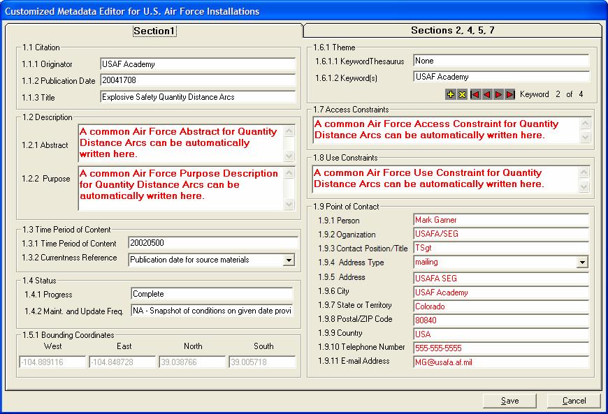
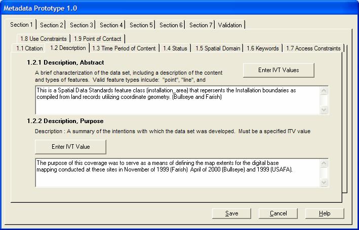
5 Customized Metadata Tools Why make customized tools? Make important metadata elements more quickly accessible More closely link metadata edits with spatial/attribute edits Provide hints/assistance to ensure accuracy and completeness, adherence to Air Force standards Make metadata creation and maintenance easier and faster Automate batch changes Increased quality control!!! 5
")
6 Synchronizers The process by which properties of a data set are read from the data set and written to its metadata Purpose is to: Complete as much of the metadata as possible automatically Make sure metadata is kept up-to-date with changes to the dataset ArcCatalog comes with three synchronizers: FGDC ISO Geography Network (ESRI) 6

7 Synchronizers Synchronizers are fired when: A data set is selected in ArcCatalog and the Metadata tab is selected If there is no metadata, it is created and populated If there is metadata, it is updated When a user clicks the Create/Update metadata button in ArcCatalog Synchronizers can be disabled under Tools Options 7


8 Synchronization Process 1. Synchronization triggered 2. Update method called on synchronization manager, passes property of selected data set Synchronization manager 3. Synchronization manager finds all registered and enabled metadata synchronizers Component category manager ArcCatalog Metadata (XML) 5. Each metadata synchronizer writes to the data set s metadata 4. Synchronization manager passes the data set property to the Update method of each synchronizer identified Metadata synchronization 1 Metadata synchronization 2 Metadata synchronization 3 Source: Creating a Customized Metadata Synchronizer, an ESRI White Paper, July
9 Synchronizers Benefits An organizations name can be written each time metadata is created Contact information can be automatically written into the metadata Organizational specific hints can be automatically written into the metadata Organizational specific values can be automatically written to the metadata Undesirable effects (ie. writing of codified datum names) of default synchronizers can be eliminated 9


10 Synchronizers Air Force metadata valid values for specific SDSFIE Feature Classes can be automatically entered when the Feature Class is created 10
11 Editors The process by which metadata is manually created or edited Purpose is to: Provide access to metadata values to be entered or edited ArcCatalog comes with two Editors (ActiveX controls): FGDC ISO 11
12 Editors Editors are accessible when: A data set is selected in ArcCatalog, the Metadata tab is selected, and the open Metadata Editor is clicked The metadata editor that is used is selected under Tools Options, Metadata tab (default is FGDC). 12
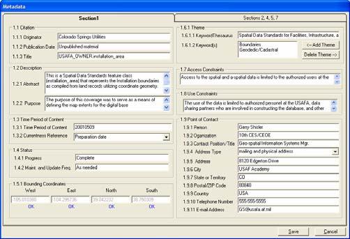
13 Editors Benefits Editor form can be tailored to an organizations unique needs Organizational specific hints and directions can be part of the form (REQUIRED ) Can be made available in ArcMap Organizational specific values can be automatically written to the metadata 13

14 Editors 14
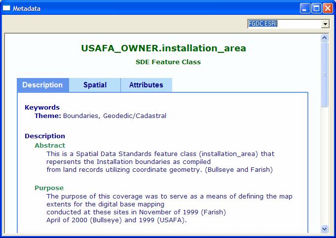
15 Style Sheets Customize the way that an organization sees the metadata Make metadata available for viewing in other applications Make metadata more readily accessible and user friendly by non-experts 15

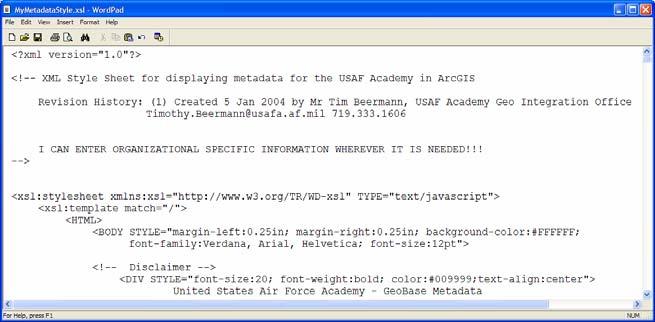
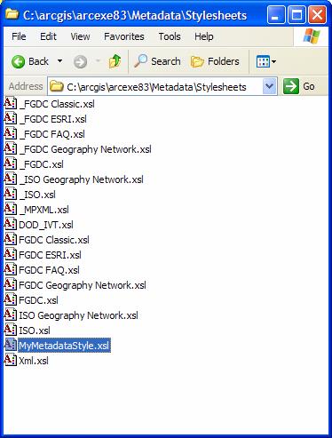
16 Style Sheets 16


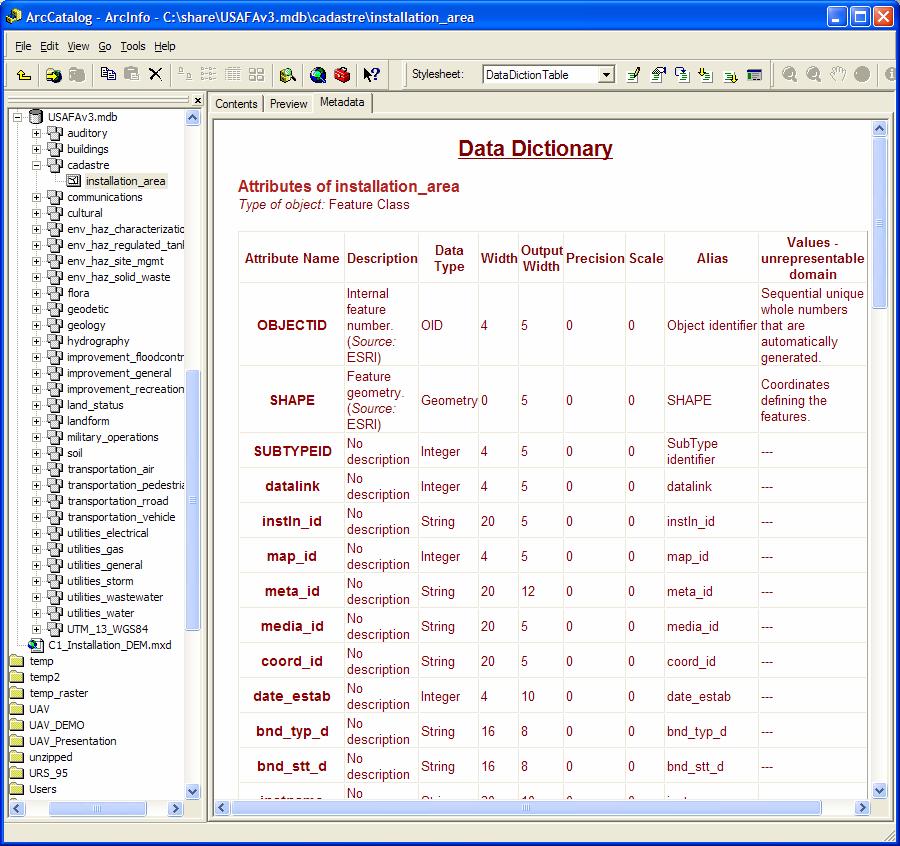
17 ESRI Style Sheet Examples 17


18 Metadata Tools 18
19 Question? Tim Beermann USAF Academy GeoBase 8120 Edgerton Drive USAF Academy, CO
Working with Metadata in ArcGIS
 Esri International User Conference San Diego, California Technical Workshops July 26, 2012 Working with Metadata in ArcGIS Aleta Vienneau Metadata in ArcGIS ArcGIS metadata goals Editing metadata Setting
ESRI stylesheet selects a subset of the entire body of the metadata and presents it as if it was in a tabbed dialog.
 Creating Metadata using ArcCatalog (ACT) 1. Choosing a metadata editor in ArcCatalog ArcCatalog comes with FGDC metadata editor, which create FGDC-compliant documentation. Metadata in ArcCatalog stored
Creating and Editing a New Shapefile
 Creating and Editing a New Shapefile Written by Barbara Parmenter, revised October, 0 CREATING AND EDITING A NEW SHAPEFILE... CREATING THE GEOGRAPHIC FEATURE (POINT, LINE, OR POLYGON)... CREATING THE ATTRIBUTE
Metadata Requirements for SanGIS Data Layers
 Metadata Requirements for SanGIS Data Layers What is Metadata? Metadata is data about data. It is information in addition to the spatial and tabular data that is required to make the data useful. Metadata
existing Click the Description Tab
 Part 2: VIEWING and EDITING EXISTING (9.3.1) FGDC METADATA in ArcGIS 10 VIEWING EXISTING VERSION 9.3.1 METADATA Upon completion of the Part 1: INITIAL SET-UP the process to VIEW, or EDIT existing FGDC
Understanding and using Metadata across the ArcGIS Platform. Aleta Vienneau Marten Hogeweg
 Understanding and using Metadata across the ArcGIS Platform Aleta Vienneau Marten Hogeweg Understanding and using Metadata across the ArcGIS Platform Metadata fundamentals ArcGIS platform Road ahead Metadata
Spatial Data Standards for Facilities, Infrastructure, and Environment (SDSFIE)
") Spatial Data Standards for Facilities, Infrastructure, and Environment (SDSFIE) Migration Workflow User Guide Version 1.0 (01 August 2018) Prepared For: US Army Corps of Engineers 2018 Revision History
Spatial Data Standards for Facilities, Infrastructure, and Environment (SDSFIE) Migration Workflow User Guide Version 1.0 (01 August 2018) Prepared For: US Army Corps of Engineers 2018 Revision History
Chapter 15 Creating and Editing Metadata
 Chapter 15 Creating and Editing Metadata If you work with computers on a regular basis, you have probably come across a file that you created a while ago and have been unable to remember exactly what is
How to Create Metadata in ArcGIS 10.0
 How to Create Metadata in ArcGIS 10.0 March 2012 Table of Contents Introduction... 1 Getting Started... 2 Software Requirements... 2 Configure ArcGIS Desktop to View FGDC Metadata... 2 Other Thoughts...
Add-In tools. Click on the. Click Add In. Manager
 Part 1: INITIAL SETUP for CREATING FGDC METADATA in ArcGIS 10 INITIAL SETUP Open ArcCatalog 10 First open and dock the Metadata Toolbarr (if not already open) by Clicking on Customize (menu) Click on Toolbars
Geospatial Databases: Metadata, Standards, and Infrastructure
 Geospatial Databases: Metadata, Standards, and Infrastructure What is metadata? Information that describes items in ArcGIS is called metadata. When care is taken to provide good descriptions, you can find
INSPIRE WS2 METADATA: Describing GeoSpatial Data
 WS2 METADATA: Describing GeoSpatial Data Susana Fontano Planning General concepts about metadata The use of standards Items about the creation of metadata Software How to create metadata The ISO19115 Standard
Understanding and Using Metadata in ArcGIS. Adam Martin Marten Hogeweg Aleta Vienneau
 Understanding and Using Metadata in ArcGIS Adam Martin Marten Hogeweg Aleta Vienneau Adam Martin National Government Account Management R&D Open Data Marten Hogeweg National Government Professional Services
Leveraging metadata standards in ArcGIS to support Interoperability. Aleta Vienneau and Marten Hogeweg
 Leveraging metadata standards in ArcGIS to support Interoperability Aleta Vienneau and Marten Hogeweg Leveraging metadata standards in ArcGIS to support Interoperability Overview of metadata standards
A Metadata Standard for IGI&S: Spatial Data Standards for Facilities, Infrastructure, and Environment - Metadata (SDSFIE-M)
") A Metadata Standard for IGI&S: Spatial Data Standards for Facilities, Infrastructure, and Environment - Metadata (SDSFIE-M) Mr. David LaBranche, PE DISDI Program Manager ODUSD(I&E) July 15, 2014 ESRI IUC
A Metadata Standard for IGI&S: Spatial Data Standards for Facilities, Infrastructure, and Environment - Metadata (SDSFIE-M) Mr. David LaBranche, PE DISDI Program Manager ODUSD(I&E) July 15, 2014 ESRI IUC
Configuring WO Automation for Radio for TuneGenie
 Configuring WO Automation for Radio for TuneGenie As WO Automation for Radio events fire, XML data is published through Device Server through a configured TCP port. First create the Device Server TCP Port,
Exercise 1: Getting to know ArcGIS
 The Scenario You are working for the California Visitor s Commission. You have been asked to prepare a map of California for several dignitaries from out of the country. Your map will need to include enough
Introduction to Geographic Information Systems Spring 2016
 Introduction to Geographic Information Systems Spring 2016 Exercise 2 Introduction to ArcGIS 10 Projects This exercise will introduce you to the common set-up functions of the ESRI ArcGIS software package.
Troubleshooting Performance Issues with Enterprise Geodatabases. Ben Lin, Nana Dei, Jim McAbee
 Troubleshooting Performance Issues with Enterprise Geodatabases Ben Lin, Nana Dei, Jim McAbee blin@esri.com ndei@esri.com jmcabee@esri.com Workshop Agenda Performance Troubleshooting (Then & Now) Real-World
Answer the following general questions: 1. What happens when you right click on an icon on your desktop? When you left double click on an icon?
 Name: Date: June 27th, 2011 GIS Boot Camps For Educators Practical: Explore ArcGIS 10 Desktop Tools and functionality Day_1 Lecture 1 Sources: o ArcGIS Desktop help o ESRI website o Getting to Know ArcGIS
Spatial Data Standards for Facilities, Infrastructure, and Environment (SDSFIE)
") Spatial Data Standards for Facilities, Infrastructure, and Environment (SDSFIE) Model Builder User Guide Version 1.3 (24 April 2018) Prepared For: US Army Corps of Engineers 2018 Revision History Model
Spatial Data Standards for Facilities, Infrastructure, and Environment (SDSFIE) Model Builder User Guide Version 1.3 (24 April 2018) Prepared For: US Army Corps of Engineers 2018 Revision History Model
Metadata or "data about data" describe the content, quality, condition, and other characteristics of data. The Federal Geographic Data Committee
 Metadata or "data about data" describe the content, quality, condition, and other characteristics of data. The Federal Geographic Data Committee (http://www.fgdc.gov/) approved the Content Standard for
Synchronization in ArcCatalog
 An ESRI Technical Paper August 2001 ESRI 380 New York St., Redlands, CA 92373-8100, USA TEL 909-793-2853 FAX 909-793-5953 E-MAIL info@esri.com WEB www.esri.com Copyright 2001 ESRI All rights reserved.
Geospatial Multistate Archive and Preservation Partnership Metadata Comparison
 Geospatial Multistate Archive and Preservation Partnership Metadata Comparison Cindy Clark, Utah s Automated Geographic Reference Center Glen McAninch, Kentucky Dept. for Libraries and Archives Steve Morris,
Introduction to ArcCatalog
 Introduction to ArcCatalog Introduction To Arc Catalog ArcCatalog is a data- centric GUI tool used for managing spatial data With ArcCatalog you can. Inspect properties and attributes of data Preview and
Approaching Data Quality
 USAF 2004 GeoBase Compass Conference 18 Aug 2004 Approaching Data Quality Mr. Nathan Lowry HQ AFSPC/CEXI AFSPC GIO Approaching Data Quality Overview DoD Standards and Flexibility Extending Standards to
Presented by Kit Na Goh
 Developing A Geo-Spatial Search Tool Using A Relational Database Implementation of the FGDC CSDGM Model Presented by Kit Na Goh Introduction Executive Order 12906 was issued on April 13, 1994 with the
SHARING GEOGRAPHIC INFORMATION ON THE INTERNET ICIMOD S METADATA/DATA SERVER SYSTEM USING ARCIMS
 SHARING GEOGRAPHIC INFORMATION ON THE INTERNET ICIMOD S METADATA/DATA SERVER SYSTEM USING ARCIMS Sushil Pandey* Birendra Bajracharya** *International Centre for Integrated Mountain Development (ICIMOD)
Heads up Digitizing v 9.3
 Heads up Digitizing v 9.3 Created by Vince DiNoto Vince.dinoto@kctcs.edu Table of Contents Prerequisite... 2 Getting Started... 2 ArcCatalog ArcMap Projection... 4 Attribute Table... 6 Editor... 7 Table
Tutorial 1: Finding and Displaying Spatial Data Using ArcGIS
 Tutorial 1: Finding and Displaying Spatial Data Using ArcGIS This tutorial will introduce you to the following: Websites where you may browse to find geospatial information Identifying spatial data, usable
North Carolina State Archives: CONTENTdm User Guide for Geospatial Datasets (December 16, 2011)
") CONTENTdm Process Overview: CONTENTdm 1 is a windows-based, digital collection builder where data and digital items are prepared in large batches via the CONTENTdm Project Client and then uploaded to a
CONTENTdm Process Overview: CONTENTdm 1 is a windows-based, digital collection builder where data and digital items are prepared in large batches via the CONTENTdm Project Client and then uploaded to a
Search & Rescue Map Specifications and Production Workflows
 Search & Rescue Map Specifications and Production Workflows About The Search & Rescue map product and production procedures discussed in this document can be utilized to support search, rescue, and relief
Using XML Notepad to Read, Edit, and Parse FGDC-CSDGM XML Metadata.
 Using XML Notepad to Read, Edit, and Parse FGDC-CSDGM XML Metadata. Currently many tools exist that allow a user to work with XML metadata files. However, most of the main metadata creation/editing tools
Copyright 2002, 2004 ESRI All rights reserved. Printed in the United States of America.
 Copyright 2002, 2004 ESRI All rights reserved. Printed in the United States of America. The information contained in this document is the exclusive property of ESRI. This work is protected under United
Worksheet for minimally-compliant FGDC metadata
 Metadata Worksheet P. 1 of 8 Worksheet for minimally-compliant FGDC metadata The purpose of this worksheet is to provide an outline for high level geospatial metadata information gathering. It should help
PNAMP Metadata Builder Prototype Development Summary Report December 17, 2012
 PNAMP Metadata Builder Prototype Development Summary Report December 17, 2012 Overview Metadata documentation is not a commonly embraced activity throughout the region. But without metadata, anyone using
DAP Administrator 11 User Guide
 DAP Administrator 11 User Guide www.geosoft.com Contents Chapter 1: DAP Administrator 1 DAP Administrator Overview 1 New Features in DAP Administrator 11 1 Chapter 2: Install DAP Administrator 4 Installing
ArcGIS Server: publishing geospatial data to the web using the EEA infrastructure
 ArcGIS Server: publishing geospatial data to the web using the EEA infrastructure *IMPORTANT: Map Services should be published using the EEA Map Services Tick Sheet for guidance. Contact Sebastien Petit
ICIT. Brian Hiller ESRI Account Manger. What s new in ArcGIS 10
 ICIT Brian Hiller ESRI Account Manger What s new in ArcGIS 10 ArcGIS 10 Fast Easy Powerful Everywhere late June 2010 ArcGIS System for Geographic Information Desktop Server Mobile Online A System A Complete
How to Set Workspace Environments for Project Work
 How to Set Workspace Environments for Project Work An ESRI Short Tutorial January 2006 ESRI 380 New York St., Redlands, CA 92373-8100, USA TEL 909-793-2853 FAX 909-793-5953 E-MAIL info@esri.com WEB www.esri.com
Fast Track Model Based Design and Development with Oracle9i Designer. An Oracle White Paper August 2002
 Fast Track Model Based Design and Development with Oracle9i Designer An Oracle White Paper August 2002 Fast Track Model Based Design and Development with Oracle9i Designer Executive Overivew... 3 Introduction...
DATA SHARING AND DISCOVERY WITH ARCGIS SERVER GEOPORTAL EXTENSION. Clive Reece, Ph.D. ESRI Geoportal/SDI Solutions Team
 DATA SHARING AND DISCOVERY WITH ARCGIS SERVER GEOPORTAL EXTENSION Clive Reece, Ph.D. ESRI Geoportal/SDI Solutions Team Geoportal Extension for ArcGIS Server Context within an Enterprise Spatial Data Infrastructure
SDSFIE Online: What's New and Improved
 SDSFIE Online: What's New and Improved Mr. Kurt Buehler DISDI Program Team OASD(EI&E) July 11, 2017 Agenda Overview of SDSFIE Online What s New and Improved: SDSFIE-Vector Tools & Workflows Change Management
The Scottish Spatial Data Infrastructure (SSDI)
") The Scottish Spatial Data Infrastructure (SSDI) INSPIRE Conference Istanbul Monday 25 th June 2012 15:55 Geoportals and registries II Tim Duffy BGS Edinburgh (trd@bgs.ac.uk) Shona Nicol Alex Ramage NERC
The Scottish Spatial Data Infrastructure (SSDI) INSPIRE Conference Istanbul Monday 25 th June 2012 15:55 Geoportals and registries II Tim Duffy BGS Edinburgh (trd@bgs.ac.uk) Shona Nicol Alex Ramage NERC
ArcGIS Desktop: Introduction to Geoprocessing with ModelBuilder Kevin Armstrong ESRI
 ArcGIS Desktop: Introduction to Geoprocessing with ModelBuilder Kevin Armstrong ESRI SERUG 2008 1 What is ModelBuilder? A user-friendly way to automate a series of tools Part of the ArcGIS geoprocessing
ModelBuilder: An Introduction. Kevin Armstrong
 ModelBuilder: An Introduction Kevin Armstrong What is ModelBuilder? A user-friendly way to automate a series of tools Part of the ArcGIS geoprocessing framework - ModelBuilder can run any tool in the ArcToolbox,
ESRI Technology Update. Joe Holubar Larry Young
 ESRI Technology Update Joe Holubar Larry Young Continued Improvement Improving Quality and Extending and Refining Functionality First Half of 2009: Minor Update Release (ArcGIS 9.3.1) ArcGIS Explorer Fall
ArcGIS Basics Working with Labels and Annotation
 ArcGIS Basics Working with Labels and Annotation Labeling in ArcGIS has changed considerably from the old ArcView 3.X version. In ArcGIS label positions are generated automatically, are not selectable,
ArcGIS 9. Using ArcCatalog
 ArcGIS 9 Using ArcCatalog Copyright 1999, 2003 2004 ESRI All rights reserved. Printed in the United States of America. The information contained in this document is the exclusive property of ESRI. This
This support note will discuss several methods of creating no spray zones for Sentinel GIS>
 Reason Sentinel Adulticiding support a polygon no spray layer. Adulticiding mobile software warns the driver when they are approaching a no spray zone so they can turn off the sprayer. Because no spray
Laserfiche Import Agent Quick Start Guide. White Paper
 Laserfiche Import Agent Quick Start Guide White Paper Table of Contents Welcome to Import Agent... 3 What s New in Import Agent 10?... 4 Getting Started... 5 Import Agent Configuration Utility... 5 Creating
Enhancements to Optiplant Configurator Version 4.7 Release Date: March
 Enhancements to Optiplant Configurator Version 4.7 Release Date: March 23 2012 MODULE FEATURE DESCRIPTION Project Creation 1. License-in-use prompt. 1. This new feature automatically identifies the licenses
Part of User Manual to install the Eurosion Database on ArcGIS software. European Commission Contract Nr. B4-3301/2001/329175/MAR/B3
 Part of User Manual to install the Eurosion Database on ArcGIS software European Commission Contract Nr. B4-3301/2001/329175/MAR/B3 Paris, 19 th March 2004 - KEYWORDS SUMMARY Database Installation, Guide,
Release notes for version 3.7.1
 Release notes for version 3.7.1 Important! Create a backup copy of your projects before updating to the new version. Projects saved in the new version can t be opened in versions earlier than 3.7. What
Leveraging OGC Services in ArcGIS Server. Satish Sankaran, Esri Yingqi Tang, Esri
 Leveraging OGC Services in ArcGIS Server Satish Sankaran, Esri Yingqi Tang, Esri GIS Creating and Managing Geo Information Products - Proprietary - Open Specifications - Standards Dissemination of Geo
ArcGIS 9. Using ArcCatalog
 ArcGIS 9 Using ArcCatalog Copyright 1999, 2003 2005 ESRI All rights reserved. Printed in the United States of America. The information contained in this document is the exclusive property of ESRI. This
Setup Guide for Op Tracker
 Setup Guide for Op Tracker Contents 1 Welcome to Op Tracker... 2 2 Data Overview... 3 2.1 Block Boundary Feature Layer... 3 2.2 Block Tracking Feature Layer... 3 2.3 Ancillary Data Feature Layer... 3 2.4
Best Practices for Choosing Content Reporting Tools and Datasources. Andrew Grohe Pentaho Director of Services Delivery, Hitachi Vantara
 Best Practices for Choosing Content Reporting Tools and Datasources Andrew Grohe Pentaho Director of Services Delivery, Hitachi Vantara Agenda Discuss best practices for choosing content with Pentaho Business
An Introduction to Geographic Information Systems (GIS) using ArcGIS 9.2
 using ArcGIS 9.2") An Introduction to Geographic Information Systems (GIS) using ArcGIS 9.2 by Marcel Fortin, GIS and Map Librarian, University of Toronto Libraries, 2009 gis.maps@utoronto.ca http://www.library.utoronto.ca/maplib/
An Introduction to Geographic Information Systems (GIS) using ArcGIS 9.2 by Marcel Fortin, GIS and Map Librarian, University of Toronto Libraries, 2009 gis.maps@utoronto.ca http://www.library.utoronto.ca/maplib/
Leveraging metadata standards in ArcGIS to support Interoperability. David Danko and Aleta Vienneau
 Leveraging metadata standards in ArcGIS to support Interoperability David Danko and Aleta Vienneau Leveraging Metadata Standards in ArcGIS for Interoperability Why metadata and metadata standards? Overview
Content Module. ActiveModeler Avantage. Managing Enterprise Documentation. Version 1.2, 6 May KAISHA-Tec What does the Content Module do?
 ActiveModeler Avantage Managing Enterprise Documentation Content Module User Guide Version 1.2, 6 May 2009 ActiveModeler, ActiveFlow and ActiveModeler Avantage are registered trademarks of KAISHA-Tec Co.
FME / ArcGIS 9 Data Interoperability Extension
 FME / ArcGIS 9 Data Interoperability Extension About us Founded: 1993 Head office: Vancouver, Canada # of Employees: 45 Target markets: GIS & GPS vendors, Telecom and utilities, Oil & gas, Government agencies
2) Make sure that the georeferencing extension is on by right-clicking in the task bar area and selecting Georeferencing
 Make sure that the georeferencing extension is on by right-clicking in the task bar area and selecting Georeferencing") HGIS Workshop Module 1 Georeferencing Large Scale Scanned Historical Maps Objective: Learn the Principles of Georeferencing 1) In ArcMap, open the project 01 data\arcdata_10_1\arcdata\toronto\georeference.mxd
HGIS Workshop Module 1 Georeferencing Large Scale Scanned Historical Maps Objective: Learn the Principles of Georeferencing 1) In ArcMap, open the project 01 data\arcdata_10_1\arcdata\toronto\georeference.mxd
Achieving Interoperability using the ArcGIS Platform. Satish Sankaran Roberto Lucchi
 Achieving Interoperability using the ArcGIS Platform Satish Sankaran Roberto Lucchi Thank you Please fill out the session survey in your mobile app Select [Achieving Interoperability using the ArcGIS Platform]
LAB 1: Introduction to ArcGIS 8
 LAB 1: Introduction to ArcGIS 8 Outline Introduction Purpose Lab Basics o About the Computers o About the software o Additional information Data ArcGIS Applications o Starting ArcGIS o o o Conclusion To
Guide to Editing Map Legends
 Guide to Editing Map Legends Map legends explain map symbols and are crucial to the communication of a map s message. Effective legends are created with careful consideration of labels and text, classes,
Best Practices Outline for Deep Dish Television
 Best Practices Outline for Deep Dish Television Tape management 1) Click Save tabs and rewind completely after capture. 2) Label tapes with Deep Dish ; videographer s name; content description; date of
How to become an INSPIRE node and fully exploit the investments made?
 How to become an INSPIRE node and fully exploit the investments made? Solution patterns for consumers: end users & developers (2/2) Roberto Lucchi 22 June 2010, Krakow 1 Geoportal extension Enabling discovery
Exercise 1: An Overview of ArcMap and ArcCatalog
 Exercise 1: An Overview of ArcMap and ArcCatalog Introduction: ArcGIS is an integrated collection of GIS software products for building a complete GIS. ArcGIS enables users to deploy GIS functionality
Implementation of a reporting workflow to maintain data lineage for major water resource modelling projects
 18 th World IMACS / MODSIM Congress, Cairns, Australia 13-17 July 2009 http://mssanz.org.au/modsim09 Implementation of a reporting workflow to maintain data lineage for major water Merrin, L.E. 1 and S.M.
USER GUIDE. MADCAP FLARE 2017 r3. Accessibility
 USER GUIDE MADCAP FLARE 2017 r3 Accessibility Copyright 2018 MadCap Software. All rights reserved. Information in this document is subject to change without notice. The software described in this document
Army ITAM GIS: Utilizing ArcSDE and SDSFIE to Support the Enterprise
 Army ITAM GIS: Utilizing ArcSDE and SDSFIE to Support the Enterprise Gary Senseman ITAM GIS Western Regional Support, Center for Environmental Management of Military Lands, Colorado State University, Fort
Moving Dynamic Segmentation to the Server: Linear Referencing for Web- Based Applications
 Moving Dynamic Segmentation to the Server: Linear Referencing for Web- Based Applications Paper 6.4.2 Graham Stickler and Rob Coupe Exor Corporation Contents Why move things to the database Oracle spatial
Exercise 5: Import Tabular GPS Data and Digitizing
 Exercise 5: Import Tabular GPS Data and Digitizing You can create NEW GIS data layers by digitizing on screen with an aerial photograph or other image as a back-drop. You can also digitize using imported
Leverage custom geographical polygons in SAS Visual Analytics
 ABSTRACT Paper SAS1732-2018 Leverage custom geographical polygons in SAS Visual Analytics Falko Schulz, SAS Institute Inc., Brisbane, Australia Discover how you can explore geographical maps using your
Laboratory Topic 11: Programming in Model Builder Network (Automating Suitability Analysis)
") Laboratory Topic 11: Programming in Model Builder Network (Automating Suitability Analysis) [ LAEP/GEOG c188 ] Model Builder in ArcGIS 10.4.1 Part I: Introduction Part II: Automate Processing in Suitability
Laboratory Topic 11: Programming in Model Builder Network (Automating Suitability Analysis) [ LAEP/GEOG c188 ] Model Builder in ArcGIS 10.4.1 Part I: Introduction Part II: Automate Processing in Suitability
LocateXT ArcGIS for Server Tool User Guide Version 1.3
 LocateXT ArcGIS for Server Tool User Guide Version.3 WWW.CLEARTERRA.COM i Copyright 06, ClearTerra. All rights reserved. ClearTerra is a registered trademark of ClearTerra and Clearshark, LLC. Esri, ArcGIS,
ENGINEERING AND CONSTRUCTION BULLETIN
 ENGINEERING AND CONSTRUCTION BULLETIN No. 2018-7 Issuing Office: CECW-EC Issued: 06 Jun 18 Expires: 06 Jun 20 SUBJECT: Advanced Modeling Requirements on USACE Projects CATEGORY: Directive and Policy 1.
Appraisal Templates. Table of Contents. Introduction... 2 System Options... 2 Using the Appraisal Templates... 2 Editing Appraisal Templates...
 Table of Contents Introduction... 2 System Options... 2 Using the Appraisal Templates... 2 Editing Appraisal Templates... 6 27 July 2017 TIP-2017-089 1 Introduction The Appraisal Templates feature offers
ArcGIS Online: Three-and-a-Half Ways to Create Tile Layers. Eric Anderson & Adam Eversole Esri Support Services
 ArcGIS Online: Three-and-a-Half Ways to Create Tile Layers Eric Anderson & Adam Eversole Esri Support Services Agenda 1. Introduction 2. What is a tile layer 3. How a tile layer works 4. The 3 ½ ways to
Energy Industry Profile An Update from the Metadata Work Group
 Energy Industry Profile An Update from the Metadata Work Group May 1, 2012 PUG Conference 2012 Houston, Texas Metadata Work Group Outline Metadata Initiative Background / EIP Overview 2012 Release of EIP
GENERAL FUND ENTERPRISE BUSINESS SYSTEM. Transaction SBWP IDoc Error Reporting via Business Workplace Job Aid
 GENERAL FUND ENTERPRISE BUSINESS SYSTEM Transaction SBWP IDoc Error Reporting via Business Workplace Job Aid Version 1.0 Prepared by Accenture August 10, 2009 IDoc Error Reporting via SBWP Job Aid Overview
ArcGIS Desktop: Fundamentals of Cartography
 ArcGIS Desktop: Fundamentals of Cartography Outline Symbology Style Files -.style Layer files -.lyr Labeling Label Classes Label Expressions Map Document files -.mxd Map Template files -.mxt Map Elements
Customization of ArcGIS Pro: WSDOT s GIS Workbench Data Access Add-In
 Customization of ArcGIS Pro: WSDOT s GIS Workbench Data Access Add-In Richard C. Daniels & Jordyn Mitchell Washington State Department of Transportation, Information Technology Division, P.O. Box 47430,
Creating a Data Dictionary in GPS Pathfinder Office
 Overview Data dictionaries define the types of features that you can collect in the field. The types of features are point, line, and polygon. Attributes are the information about the feature that need
ArcGIS Online Tutorial
 ArcGIS Online Tutorial ArcGIS Online allows users to make interactive maps or applications and easily share them with others. The University of Minnesota has an organizational account that can be logged
Mikon Client Release Notes
 1(9) Mikon Client 4.0 is a major new release with a modern ribbon style menu replacing the old menu and toolbar. It will make it easier to see and find the available functions. Other new functionality
Basic Tasks in ArcGIS 10.3.x
 Basic Tasks in ArcGIS 10.3.x This guide provides instructions for performing a few basic tasks in ArcGIS 10.3.1, such as adding data to a map document, viewing and changing coordinate system information,
Visualization with ArcGlobe. Brady Hoak
 Visualization with ArcGlobe Brady Hoak Contents What is ArcGlobe? 3D Mapping and ArcGlobe Displaying data in ArcGlobe ArcGlobe tools Tips for constructing ArcGlobe documents New at ArcGIS 9.3 ArcGIS integration
Historical GIS Workshop
 Historical GIS Workshop University of Toronto Libraries Toronto, ON July 24 and 25, 2008 Copyright 2008 Sponsored by NiCHE Network in Canadian History & Environment / Nouvelle initiative canadienne en
Working with Events in ArcGIS 8.2
 Working with Events in ArcGIS 8.2 This tutorial is a companion to the article, Understanding Dynamic Segmentation: Working with Events in ArcGIS in the October December 2002 issue of ArcUser magazine.
USER GUIDE MADCAP FLARE Accessibility
 USER GUIDE MADCAP FLARE 2018 Accessibility Copyright 2018 MadCap Software. All rights reserved. Information in this document is subject to change without notice. The software described in this document
7. METHODOLOGY FGDC metadata
 7. METHODOLOGY To enable an Internet browsing client to search and discover information through a federated metadatabase, four elements must be in place. 1. The client must be able to communicate with
Downloading Census Data from American Factfinder for use in ArcGIS
 Downloading Census Data from American Factfinder for use in ArcGIS Written by Barbara Parmenter, revised September 24 2013 OBTAINING DATA FROM AMERICAN FACTFINDER (AFF)... 1 PREPARING AMERICAN FACTFINDER
Integrating ArcGIS to Enterprise Oracle Spatial Using Direct Connect
 Integrating ArcGIS to Enterprise Oracle Spatial Using Direct Connect Michael D. Tsengouras Principal Software Engineer Navigation Technologies Corporation Abstract: Many organizations are adopting Enterprise
A Second Look at DEM s
 A Second Look at DEM s Overview Detailed topographic data is available for the U.S. from several sources and in several formats. Perhaps the most readily available and easy to use is the National Elevation
Measuring Area/Length of Organisms with GIS
 Measuring Area/Length of Organisms with GIS These instructions enable you to measure the length and area of microscopic organisms in ArcGIS from digital photographs. The four-step process involves: georeferencing
The ArcMap Interface and Using Basic ArcMap Analysis Tools to Create a Map
 The ArcMap Interface and Using Basic ArcMap Analysis Tools to Create a Map *You will need a computer with ESRI ArcGIS Desktop version 9.3 or higher installed* Data Download 1. Save the zipped folder with
Lesson 8 : How to Create a Distance from a Water Layer
 Created By: Lane Carter Advisor: Paul Evangelista Date: July 2011 Software: ArcGIS 10 Lesson 8 : How to Create a Distance from a Water Layer Background This tutorial will cover the basic processes involved