FE 257 Week 4 Topics. Final project. GIS and Forest Engineering Applications. FE 257. GIS and Forest Engineering Applications.
|
|
|
- Basil Waters
- 5 years ago
- Views:
Transcription
1 FE 257. GIS and Forest Engineering Applications Week 4 FE 257 Week 4 Topics Final project discussion Chapter 7 Buffering landscape features Chapter 3 Acquiring, creating, and editing GIS databases and examining errors Data input (GPS and other technologies) Chapter 1 Next week: Chapter 11 Chapter 8 Final project 50 points (25% of grade) Reports due by 5 PM on Friday of last week of classes 1
2 Project guidelines A spatial investigation, summary, or comparison that addresses a forest engineering or natural resources topic You may choose your own topic See me for questions about your topic See me if you need help identifying a topic Teams of two recommended People may also work individually or in threes Project requirements Cover page paper title, class number (FE 257), date, and author names 3-5 page, typed, double-spaced document that describes your project A minimum of two 8.5 x 11 inch maps in addition to your report One of the maps should be show the location of your study area. The other map(s) should show your project results. Report must have these sections: Introduction Explains the relevance of the topic and provides a brief background. Describe what you are intending to do and why it's important Methods Describe what tools (software) you used to accomplish your project. What were the key steps in answering questions related to your project? Where did your data come from? Discuss the quality of your data (including discussion of the data scale or resolution)? 2
3 Report must have these sections: Results Describe what you discovered including problems and/or successes with the methods you used. Were there any unexpected or unanticipated results? Conclusion This should contain a brief summary of the importance of your results. Do Not Put in a Plastic Cover! Geographic Information Systems Applications in Natural Resource Management Chapter 7 Buffering Landscape Features Chapter 7 Objectives Objectives: What buffering spatial landscape features accomplishes How different buffering techniques can be applied to point, line, or polygon features How buffering can be used to assess alternative management policies and to assist in making natural resource management decisions 3
4 Buffering Why? Establish leave areas or curtailing management activities within a specific distance of streams, roads, trails, or housing areas Delineating home ranges or critical habitats that capture the known nesting, roosting, or foraging sites of a wildland species Determining the potential impacts of a flood Buffering is sometimes called a proximity process How a buffer process works Features are selected for buffering Through a variety of selection processes A buffer distance is specified Can be directly input, from an attribute, or other table A line is drawn in all directions around the features until a solid polygon has been formed A new database containing the buffer results is created Point to be buffered Buffer distance Buffer around the point Figure 7. 1a. Developing a buffer around a point using an assumed buffer distance. Buffer around the line (Tangent 1) Line Vertex 1 to be Vertex 2 buffered (Tangent 2) Figure 7.1b. Developing a buffer around a line using an assumed buffer distance around the line s vertices, and tangents bridging the vertices buffers. 4
5 Buffer choices for polygons Users may select whether a buffer is created that represents The area outside of the polygon plus the entire area of the polygon The buffer area that is created both inside and outside of the polygon boundary Result 1: Buffered area represents only the area outside of the polygon that was buffered. Original polygon Outside buffer Inside buffer Tangents around vertices Result 2: Buffered area represents the area outside of the polygon that was buffered, as well as the area of the polygon itself. Result 3: Buffered area represents the area outside of the polygon that was buffered, and the area inside of the polygon that might have been buffered. Figure 7.1c. Developing a buffer around a polygon using an assumed buffer distance around the polygon s vertices, and tangents bridging the vertices buffers. Vector and raster buffering Vector buffer CPU intensive as complex geometrical processing is often necessary Output shapes must often be merged Raster buffer Simplistic in comparison to raster Involves the counting of pixels away from selected or specified pixels 5
6 # # # # Buffer distances and output Can be specific for each feature based on an attribute value Polygon output can be: A single polygon (contiguous) Individual polygons for all features (uncontiguous or noncontiguous) This allows you to specifically assess buffer results May potentially lead to overlapping buffers Most GIS packages allow you choose among these options Buffering streams (fixed width) Stream Forest boundary Stream buffer Forest boundary Buffering owl nests (fixed width) Owl nest location Forest stands Owl nest location Forest stands Owl buffer 6
7 Table 7.3. State of Oregon riparian management area policy (Oregon State Legislature 2001) Riparian management area width (feet) Domestic water use or fish-bearing Non-domestic water use and non-fish-bearing Large a Medium b Small c a Average annual flow of 10 cubic feet per second. b Average annual flow of 2 cubic feet per second and 10 cubic feet per second. c Average annual flow of 2 cubic feet per second, or drainage area 200 acres. Stream Stream Stream Buffer Stream class length (m) width (m) distance (m) Table 7.2. Ten hypothetical streams and their stream class, length, width, and buffer distance. Buffering trails and roads (variable width) McDonald Forest TRAILS ROADS 7
8 Other buffer applications Buffering trail systems or roads to delineate areas of visual sensitivity within which logging operations may be limited Buffering research areas to prevent (or hope to prevent) the planning and implementation of logging operations within them Buffering stream systems to delineate the distance herbicide operations must stay away from water systems. Local buildings (particularly houses), roads, agricultural fields, and orchards may also require buffering Problems with buffers Sub-selected features buffered instead of the entire file Wrong sub-selected features processed Contiguous and noncontiguous results mixed Geographic Information Systems Applications in Natural Resource Management Chapter 3 Acquiring, Creating, and Editing GIS Databases 8
9 Chapter 3 Objectives Methods to acquire GIS databases, particularly via the Internet Methods to create new GIS databases Processes to edit existing GIS databases Types and sources of error potentially associated with GIS databases Four general cases of GIS databases at most organizations The data necessary for project work Don t exist Do exist but were created for other general uses and may not be completely suitable for your project Do exist but were created for other specific uses and may not be completely suitable for your project The data are in place and in good order for your project! Typically, you ll have to acquire data Use a GPS or other device to capture data Modifying an existing database Create a new GIS database Digitizing Using/buying data from another organization Downloading data from the Internet 9
10 Internet acquisition Now a standard method of making data available Many federal and state organizations make spatial data available The U.S. Government is the largest producer of spatial data in the world Manual of Federal Geographic Data Products Freedom of information act allows the public some access to data created by public agencies Use these data to save time Oregon Data Sources Oregon Geospatial Data Clearinghouse (OGDC) Formerly the SSCGIS Demonstration OSU College of Forestry Bureau of Land Management (BLM) National Forest Offices (SNF) StreamNet Oregon Department of Fish and Wildlife (ODFW) Environmental Protection Agency (EPA) National Data Sources US Geological Survey (USGS) Bureau of Land Management (BLM) National Park Service (NPS) 10
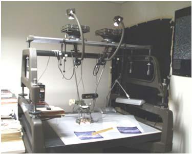
11 Acquisition processes Using an Internet browser to select and download FTP- File Transfer Protocol Transfer on hardware Tape External harddrive CD or DVD USB key Floppy Creating GIS databases We will cover these during our next meeting: Digitizing Remote Sensing Satellite imagery LIDAR Laser range finder Total station Scanning GPS Ñ Ñ Roads Stands Reference points (with associated X and Y coordinates) Ñ Ñ Figure 3.1. Measurement reference points for the Daniel Pickett forest to enable digitizing of additional landscape features or the creation of new GIS databases. 11
12 Figure 3.2. A landslide drawn on a map with a regular sharpened pencil (upper left), a marker (upper right), a sharpened pencil, yet in a sloppy manner the landslide area is not closed (lower left), a marker, yet in a sloppy manner - the landslide area is barely closed (lower right). (a) (b) (c) Figure 3.3. A timber stand (a) in vector format, from the Brown Tract, scanned (b) or converted to a raster format using 25 m grid cells, then converted back to vector format (c) by connecting lines to the center of each grid cell. Editing GIS databases Reasons for editing Edge matching GIS databases to other databases Generalization and transformation processes necessary to convert a GIS database to a specific format or resolution In natural resources, updates may occur annually to keep pace with timber inventory Growth, disturbance, harvesting 12
13 Updating processes Can be laborious and error-prone Verification protocols can help Should be in place for spatial and attribute characteristics Should involve multiple people Inventory forester maps, data files Information systems analysts Figure 3.4. A generalized process for updating a forest inventory GIS database. Delineate changes to be made to inventory maps, data files maps, data files Check data for Verification mistakes and process #1 omissions maps, data files Digitize changes to spatial data, encode inventory GIS databases Check data for mistakes and omissions Verification process #2 maps, data files Integrate into GIS database Verification process #4 Check data for mistakes and omissions GIS databases Check data for mistakes and omissions Verification process #3 Editing attributes Fields, variables, columns, data, etc. Attributes may need to be updated overtime Vegetation type, basal area, age, volume (mbf) Easy to make mistakes, particularly with major updates Verification processes can check whether values are in the appropriate range 13
14 Editing spatial position As the locations or shapes of spatial features change, their coordinates will need to be changed within the GIS database Editing procedures for this purpose vary widely among software products Typically, a database is first made editable The user then makes edits Points, lines, and/or polygons moved, copied, created, or deleted The edits are saved Often, a time-consuming procedure Consistency in spatial position When updating or creating new data, inconsistencies may result as the data are incorporated into existing databases Figure 3.5. A timber stand drawn more precisely (top) and less precisely (bottom). Note that the lines on the south and eastern portion of the figures are different. Figure 3.6. Spatial inconsistency between a timber stand GIS database and a roads GIS database. Inconsistency Roads Timber stands 14
15 Error in GIS databases Errors arise from many sources: Editing, encoding, hardware, and others Three primary sources of error in GIS data Systematic Human Random Systematic errors Sometimes called cumulative errors since they add up during data collection Sometimes called instrumental Can be removed if identified and quantified Human errors Sometimes called gross errors or blunders Verification processes can be used to control human errors Data collection and editing protocols can also assist in limiting human errors 15
16 Random errors An almost unavoidable by-product of measuring and describing landscape data No matter how careful we are in data collection procedures, there will almost always be some slight variance from the true measurement Managing random errors We assume that random errors follow a normal (Gaussian) distribution They cluster around a mean value or center Least squares adjustments can distribute and minimize the error among all measurements in a feature More frequently, and especially in forestry, we assume that random errors will cancel each other out For this reason, random errors are sometimes called Types of errors in GIS databases Positional errors occur when things are in the wrong place Can result from poor registration or inaccurate coordinate input during the digitizing process Are sometimes handled with accuracy statements: 90 percent of landscape features are within 150 meters of their true position A root mean square error (RMSE) is sometimes used to set or describe an accuracy standard A RMSE assesses the error between a mapped point and its on-the-ground (true) equivalent 16
17 Figure 3.7. Uncertainty of the local shape of a road segment (after Schneider 2001). Digitized road segment Real-world representation #1 Real-world representation #2 Real-world representation #3 Other types of errors Attribute errors Incorrect values assigned to features Can result from keyboard entry Verification processes can help alleviate these Computational errors Can be introduced during procedures Generalization Vector-to-raster transformations Interpolations Results should be carefully considered to judge appropriateness of procedures Geographic Information Systems Applications in Natural Resource Management Chapter 1 Focus: Spatial Data Collection and Input Devices 17
18 Chapter 1 Objectives Why GIS use is prevalent in natural resource management Evolution of the development of GIS technology and key figures Common spatial data collection techniques and input devices that are available Common GIS output processes that are typical in natural resource management The broad types of GIS software that are available Data collection processes & input devices Technology is constantly on the move Enhancements in digital technology for measurement applications are frequent A multitude of tools are available for spatial data capture but two important data considerations must always be taken into account regardless of the sophistication of the tool: accuracy and precision Accuracy and precision: two different animals Accuracy Accuracy is typically described in terms of a range or variance that details a threshold within which we would expect to find the likely value. Precision Can also describe the relative consistency among a set of measurements. 18

 Board has sensors that record instructions from a puck Typically digitize from a hard-copy medium")
19 Figure 1.2. Examples of accuracy and precision. Part A shows accurate and precise locations of data around the circle center; A Part B shows precise but not very accurate data; Part C shows accurate, but not very precise data, and Part D shows neither precise, nor accurate data around the C circle center. B D Digitizing Many sizes from laptop to desk-sized ($200 - $1500) Board has sensors that record instructions from a puck Typically digitize from a hard-copy medium These are transferred to board as a series of tics or registration points (Quad example) Puck is used to record points, lines, or polygons Digitizer Figure 1.3. Modern digitizing table. 19


20 Scanning of images Figure 1.4. Small format scanner. Aerial photography On-board computer Digital camera Camera field of view Figure 1.5. Digital camera mounted on airplane. Laser scanner Figure 1.6. LIDAR system on aircraft (courtesy Dr. Jason Drake, U.S. Forest Service). Height (m) Number of laser shots 20


21 Figure 1.8. Aerial photograph. Figure 1.9. Mirror stereoscope. Figure Stereoplotter. 21


22 Figure Laser range finder. Digital Total Station Handheld Data Collectors 22
 to view results Three GPS segments Control Space")
23 Global Positioning Systems Typically, most people interact with GPS through a receiver (hardware) and use a mapping program (hardware & software) to view results Three GPS segments Control Space User 23

24 GPS mechanics Called NAVSTAR (Navigation System w/ Time and Ranging)- operational in 1995 orbit the earth in 12 hours 11,000 miles above transmit microwave signals towards the earth GPS receivers on the ground receive the signals Base positions by computing the difference between time signal transmitted and received Three satellites for X and Y, four for X, Y, and Z Control segment Falcon AFB (Colorado) Six monitor stations track the satellites Ascension Island (South Atlantic Ocean) Cape Canaveral Diego Garcia (Indian Ocean) Falcon AFB (Colorado) Kwajalein Atoll (Pacific Ocean) Hawaii An almanac of satellite position is created Three ground antennas Track satellites and transmit correction information to satellites 24
 Must then")
25 Space segment Satellites have solar panels Accurate to a billionth of a second (nanosecond) GPS Principles How long did it take the satellite signal to reach the GPS receiver? The location of the satellite at the exact instant it sent the signal must also be communicated Atmospheric conditions must also be accounted for Satellite signals start in a vacuum (space) Must then must travel through the atmosphere Delay of GPS signal through atmosphere is measured GPS Principles The GPS receiver must also be able to identify each satellite it receives signals from Three signals allows the GPS receiver to compute longitude and latitude Through process of trilateration Four GPS satellite signals are needed to compute positions in three dimensions Signals are sometimes hard to get Topography, cover Satellite position Atmospheric interference 25

26 User segment: GPS receivers Several broad categories $ $1,500-10,000 $10,000 and up Consumer grade GPS receivers Handheld Inexpensive Coarse location measurements (5-10 m) Points can be saved and downloaded in some packages User unable to set minimum quality of signals Allows forest measurements to be collected Garmin, Lowrance, Brunton, Deloreme, Magellan Mapping grade GPS Handheld or backpack Thousands of dollars Moderate location measurement accuracy (1-5 m) Points can be saved and downloaded User can set minimum quality of signals Differential correction possible with many Trimble, Archer, SXBlue, CMT 26


27 Mapping grade GPS receiver and data collector in use Survey grade GPS Most accurate (< cm) and expensive User can set minimum quality of signals Used for precise earth measurements, determining construction project measurements, property measurements, and other applications when precision and accuracy are essential Differential correction possible Topcon, Trimble, Leica,Thales ProMark, Ashtech Summary: GPS Principles Control, space, and user segments Satellite signals carry: Time, satellite position, atmospheric information, satellite ID Control segment monitors the space segment GPS receivers represent the user segment and allow position determination 27
28 GPS Error Sources GPS still suffers from problems with accuracy, particularly in forested and uneven terrain GPS Error Sources Multipathing GPS signals reflect off another surface before reaching GPS receiver Buildings, structures, vehicles Trees, water, vegetation Some GPS software can reduce, but not eliminate, multipath errors Multipath error Multipath error Road location 28
29 GPS Error: Atmospheric, digital, and mechanical Troposphere/Ionosphere (< 4m) Travel time of signal Receiver Error (< 2m) Rounding, false position Ephemeris Error (< 1m) Clock Error (<1 m) GPS Accuracy Position Dilution of Precision (PDOP) General guideline: < 6 Composed of: Horizontal Dilution of Precision (HDOP) Vertical Dilution of Precision (VDOP) Differential Correction Not available to consumer grade receivers Except real-time differential correction (WAAS) Can remove some of the error but does not address multipath errors Coordinates collected in the field are postprocessed in the office Uses a base station at a known X, Y, and Z Base station computes measurement error based on satellite signals Rover (GPS receiver) communicates with base station to apply correction to measurements 29
30 Differential Correction Can also involve two field-based GPS receivers One at a known point The other serves as a rover Differential correction can occur After the data collection Post-processed differential correction During the time of data collection Real-time differential correction (RTK GPS) Real-time Kinematic GPS A differential correction GPS method: the rover is continually moving or stopping only briefly Sometimes the rover and base station leap frog each other to increase ground coverage Corrections are communicated to the rover from the base station in real time using a radio or cellular connection Can collect points faster but usually offers tradeoffs to accuracy GPS challenges in natural resources Acquire and retain sufficient number of satellites and signal strength Forest canopy and topography can block lines of sight between satellites and receiver Can sometimes be alleviated through software that depicts best times for maximum satellite coverage Multipath errors Satellite signals which reflect off an object before reaching receiver Things are improving, however! 30
31 GPS applications in natural resources GPS has become widespread for collecting spatial data Unit boundaries Gradients and profiles Riparian corridors and other management areas Roads, streams, and other linear features Nest locations Almost all activities result in coordinates being mapped GPS collected data is typically downloaded to a computer mapping and analysis GPS Mission Planning Two primary considerations Number of available satellites Predicted PDOP User must supply Location Date(s) Available free at: 31
GIS and Forest Engineering Applications
 FE 257. GIS and Forest Engineering Applications Week 3 This week s topics Clip and erase processes Chapter 6 Selecting landscape features in a GIS Chapter 5 GIS Lab3: Determining land use and ownership
Mid-term exam. GIS and Forest Engineering Applications. Week 5. FE 257. GIS and Forest Engineering Applications. Week 5
 FE 257. GIS and Forest Engineering Applications Week 5 Week 5 Last week (Chapter 3): Acquiring, creating, and editing GIS s Examining Error Chapter 7 Buffering and other proximity operations Questions?
An Introduction to Lidar & Forestry May 2013
 An Introduction to Lidar & Forestry May 2013 Introduction to Lidar & Forestry Lidar technology Derivatives from point clouds Applied to forestry Publish & Share Futures Lidar Light Detection And Ranging
Contents of Lecture. Surface (Terrain) Data Models. Terrain Surface Representation. Sampling in Surface Model DEM
 Data Models. Terrain Surface Representation. Sampling in Surface Model DEM") Lecture 13: Advanced Data Models: Terrain mapping and Analysis Contents of Lecture Surface Data Models DEM GRID Model TIN Model Visibility Analysis Geography 373 Spring, 2006 Changjoo Kim 11/29/2006 1
Lecture 13: Advanced Data Models: Terrain mapping and Analysis Contents of Lecture Surface Data Models DEM GRID Model TIN Model Visibility Analysis Geography 373 Spring, 2006 Changjoo Kim 11/29/2006 1
About LIDAR Data. What Are LIDAR Data? How LIDAR Data Are Collected
 1 of 6 10/7/2006 3:24 PM Project Overview Data Description GIS Tutorials Applications Coastal County Maps Data Tools Data Sets & Metadata Other Links About this CD-ROM Partners About LIDAR Data What Are
4.0 DIGITIZATION, EDITING AND STRUCTURING OF MAP DATA
 .0 DIGITIZATION, EDITING AND STRUCTURING OF MAP DATA The process of digitizing existing maps is a transformation from one analog) form of information to another digital) form. Data input is the operation
Central Coast LIDAR Project, 2011 Delivery 1 QC Analysis LIDAR QC Report February 17 th, 2012
 O R E G O N D E P A R T M E N T O F G E O L O G Y A N D M I N E R A L I N D U S T R I E S OLC Central Coast Delivery 1 Acceptance Report. Department of Geology & Mineral Industries 800 NE Oregon St, Suite
GIS LAB 8. Raster Data Applications Watershed Delineation
 GIS LAB 8 Raster Data Applications Watershed Delineation This lab will require you to further your familiarity with raster data structures and the Spatial Analyst. The data for this lab are drawn from
APPENDIX E2. Vernal Pool Watershed Mapping
 APPENDIX E2 Vernal Pool Watershed Mapping MEMORANDUM To: U.S. Fish and Wildlife Service From: Tyler Friesen, Dudek Subject: SSHCP Vernal Pool Watershed Analysis Using LIDAR Data Date: February 6, 2014
Airborne LiDAR Data Acquisition for Forestry Applications. Mischa Hey WSI (Corvallis, OR)
") Airborne LiDAR Data Acquisition for Forestry Applications Mischa Hey WSI (Corvallis, OR) WSI Services Corvallis, OR Airborne Mapping: Light Detection and Ranging (LiDAR) Thermal Infrared Imagery 4-Band
Airborne LiDAR Data Acquisition for Forestry Applications Mischa Hey WSI (Corvallis, OR) WSI Services Corvallis, OR Airborne Mapping: Light Detection and Ranging (LiDAR) Thermal Infrared Imagery 4-Band
N.J.P.L.S. An Introduction to LiDAR Concepts and Applications
 N.J.P.L.S. An Introduction to LiDAR Concepts and Applications Presentation Outline LIDAR Data Capture Advantages of Lidar Technology Basics Intensity and Multiple Returns Lidar Accuracy Airborne Laser
LIDAR MAPPING FACT SHEET
 1. LIDAR THEORY What is lidar? Lidar is an acronym for light detection and ranging. In the mapping industry, this term is used to describe an airborne laser profiling system that produces location and
IMAGINE Objective. The Future of Feature Extraction, Update & Change Mapping
 IMAGINE ive The Future of Feature Extraction, Update & Change Mapping IMAGINE ive provides object based multi-scale image classification and feature extraction capabilities to reliably build and maintain
2-4 April 2019 Taets Art and Event Park, Amsterdam CLICK TO KNOW MORE
 Co-Host Host 2-4 April 2019 Taets Art and Event Park, Amsterdam CLICK TO KNOW MORE Presentation Outline review modern survey methodologies available to support railway requirements measuring everything
GPS Located Accuracy Assessment Plots on the Modoc National Forest
 This file was created by scanning the printed publication. Errors identified by the software have been corrected; however, some errors may remain. GPS Located Accuracy Assessment Plots on the Modoc National
Welcome to NR402 GIS Applications in Natural Resources. This course consists of 9 lessons, including Power point presentations, demonstrations,
 Welcome to NR402 GIS Applications in Natural Resources. This course consists of 9 lessons, including Power point presentations, demonstrations, readings, and hands on GIS lab exercises. Following the last
GIS in agriculture scale farm level - used in agricultural applications - managing crop yields, monitoring crop rotation techniques, and estimate
 Types of Input GIS in agriculture scale farm level - used in agricultural applications - managing crop yields, monitoring crop rotation techniques, and estimate soil loss from individual farms or agricultural
LiDAR Remote Sensing Data Collection: Yaquina and Elk Creek Watershed, Leaf-On Acquisition
 LiDAR Remote Sensing Data Collection: Yaquina and Elk Creek Watershed, Leaf-On Acquisition Submitted by: 4605 NE Fremont, Suite 211 Portland, Oregon 97213 April, 2006 Table of Contents LIGHT DETECTION
CLASSIFICATION OF NONPHOTOGRAPHIC REMOTE SENSORS
 CLASSIFICATION OF NONPHOTOGRAPHIC REMOTE SENSORS PASSIVE ACTIVE DIGITAL CAMERA THERMAL (e.g. TIMS) VIDEO CAMERA MULTI- SPECTRAL SCANNERS VISIBLE & NIR MICROWAVE HYPERSPECTRAL (e.g. AVIRIS) SLAR Real Aperture
GIS Data Collection. This chapter reviews the main methods of GIS data capture and transfer and introduces key practical management issues.
 9 GIS Data Collection OVERVIEW This chapter reviews the main methods of GIS data capture and transfer and introduces key practical management issues. It distinguishes between primary (direct measurement)
Aerial and Mobile LiDAR Data Fusion
 Creating Value Delivering Solutions Aerial and Mobile LiDAR Data Fusion Dr. Srini Dharmapuri, CP, PMP What You Will Learn About LiDAR Fusion Mobile and Aerial LiDAR Technology Components & Parameters Project
Alaska Department of Transportation Roads to Resources Project LiDAR & Imagery Quality Assurance Report Juneau Access South Corridor
 Alaska Department of Transportation Roads to Resources Project LiDAR & Imagery Quality Assurance Report Juneau Access South Corridor Written by Rick Guritz Alaska Satellite Facility Nov. 24, 2015 Contents
GPS/GIS Activities Summary
 GPS/GIS Activities Summary Group activities Outdoor activities Use of GPS receivers Use of computers Calculations Relevant to robotics Relevant to agriculture 1. Information technologies in agriculture
Sandy River, OR Bathymetric Lidar Project, 2012 Delivery QC Analysis Lidar QC Report March 26 th, 2013
 O R E G O N D E P A R T M E N T O F G E O L O G Y A N D M I N E R A L I N D U S T R I E S OLC Sandy River, OR Bathymetric Lidar Project Delivery Acceptance Report. Department of Geology & Mineral Industries
ROCKY FORK TRACT: VIEWSHED ANALYSIS REPORT
 ROCKY FORK TRACT: VIEWSHED ANALYSIS REPORT Prepared for: The Conservation Fund Prepared by: A Carroll GIS 3711 Skylark Trail Chattanoga, TN 37416 INTRODUCTION This report documents methods and results
Lidar Talking Points Status of lidar collection in Pennsylvania Estimated cost and timeline
 Lidar Talking Points Pennsylvania has an immediate need for new lidar (topographic) data coverage. Some uses of the data are enumerated later in this document. USGS has calculated an average return on
MODELLING FOREST CANOPY USING AIRBORNE LIDAR DATA
 MODELLING FOREST CANOPY USING AIRBORNE LIDAR DATA Jihn-Fa JAN (Taiwan) Associate Professor, Department of Land Economics National Chengchi University 64, Sec. 2, Chih-Nan Road, Taipei 116, Taiwan Telephone:
An Overview of Applanix.
 An Overview of Applanix The Company The Industry Leader in Developing Aided Inertial Technology Founded on Canadian Aerospace and Defense Industry Expertise Providing Precise Position and Orientation Systems
Remote Sensing in an
 Chapter 2: Adding Data to a Map Document Remote Sensing in an ArcMap Environment Remote Sensing Analysis in an ArcMap Environment Tammy E. Parece Image source: landsat.usgs.gov Tammy Parece James Campbell
Topographic Lidar Data Employed to Map, Preserve U.S. History
 OCTOBER 11, 2016 Topographic Lidar Data Employed to Map, Preserve U.S. History In August 2015, the National Park Service (NPS) contracted Woolpert for the Little Bighorn National Monument Mapping Project
Should Contours Be Generated from Lidar Data, and Are Breaklines Required? Lidar data provides the most
 Should Contours Be Generated from Lidar Data, and Are Breaklines Required? Lidar data provides the most accurate and reliable representation of the topography of the earth. As lidar technology advances
LIDAR and Terrain Models: In 3D!
 LIDAR and Terrain Models: In 3D! Stuart.green@teagasc.ie http://www.esri.com/library/whitepapers/pdfs/lidar-analysis-forestry.pdf http://www.csc.noaa.gov/digitalcoast/_/pdf/refinement_of_topographic_lidar_to_create_a_bare_e
Rogue River LIDAR Project, 2012 Delivery 1 QC Analysis LIDAR QC Report September 6 th, 2012
 O R E G O N D E P A R T M E N T O F G E O L O G Y A N D M I N E R A L I N D U S T R I E S OLC Rogue River Delivery 1 Acceptance Report. Department of Geology & Mineral Industries 800 NE Oregon St, Suite
Terrain Modeling and Mapping for Telecom Network Installation Using Scanning Technology. Maziana Muhamad
 Terrain Modeling and Mapping for Telecom Network Installation Using Scanning Technology Maziana Muhamad Summarising LiDAR (Airborne Laser Scanning) LiDAR is a reliable survey technique, capable of: acquiring
DEVELOPMENT OF ORIENTATION AND DEM/ORTHOIMAGE GENERATION PROGRAM FOR ALOS PRISM
 DEVELOPMENT OF ORIENTATION AND DEM/ORTHOIMAGE GENERATION PROGRAM FOR ALOS PRISM Izumi KAMIYA Geographical Survey Institute 1, Kitasato, Tsukuba 305-0811 Japan Tel: (81)-29-864-5944 Fax: (81)-29-864-2655
High-Precision Positioning Unit 2.2 Student Exercise: Calculating Topographic Change
 High-Precision Positioning Unit 2.2 Student Exercise: Calculating Topographic Change Ian Lauer and Ben Crosby (Idaho State University) Change is an inevitable part of our natural world and varies as a
Airborne Laser Scanning: Remote Sensing with LiDAR
 Airborne Laser Scanning: Remote Sensing with LiDAR ALS / LIDAR OUTLINE Laser remote sensing background Basic components of an ALS/LIDAR system Two distinct families of ALS systems Waveform Discrete Return
Notes: Notes: Notes: Notes:
 NR406 GIS Applications in Fire Ecology & Management Lesson 2 - Overlay Analysis in GIS Gathering Information from Multiple Data Layers One of the many strengths of a GIS is that you can stack several data
Review of Cartographic Data Types and Data Models
 Review of Cartographic Data Types and Data Models GIS Data Models Raster Versus Vector in GIS Analysis Fundamental element used to represent spatial features: Raster: pixel or grid cell. Vector: x,y coordinate
MODULE 1 BASIC LIDAR TECHNIQUES
 MODULE SCENARIO One of the first tasks a geographic information systems (GIS) department using lidar data should perform is to check the quality of the data delivered by the data provider. The department
BLM Fire Project, 2013 QC Analysis Lidar and Orthophoto QC Report November 25th, 2013
 O R E G O N D E P A R T M E N T O F G E O L O G Y 1937 A N D M I N E R A L I N D U S T R I E S Department of Geology & Mineral Industries 800 NE Oregon St, Suite 965 Portland, OR 97232 BLM Fire Project,
Lecture 06. Raster and Vector Data Models. Part (1) Common Data Models. Raster. Vector. Points. Points. ( x,y ) Area. Area Line.
 Common Data Models. Raster. Vector. Points. Points. ( x,y ) Area. Area Line.") Lecture 06 Raster and Vector Data Models Part (1) 1 Common Data Models Vector Raster Y Points Points ( x,y ) Line Area Line Area 2 X 1 3 Raster uses a grid cell structure Vector is more like a drawn map
Lecture 06 Raster and Vector Data Models Part (1) 1 Common Data Models Vector Raster Y Points Points ( x,y ) Line Area Line Area 2 X 1 3 Raster uses a grid cell structure Vector is more like a drawn map
TOPOGRAPHY - a LIDAR Simulation
 Title TOPOGRAPHY - a LIDAR Simulation Grade Level(s): 9-12 Estimated Time: 1.5 hours Discussion of Technology: Appendix A Construction Details: Appendix B MSDE Indicator(s) Goal 1: Skills and Processes
Applications of LiDAR in seismic acquisition and processing Mark Wagaman and Ron Sfara, Veritas DGC
 Applications of LiDAR in seismic acquisition and processing Mark Wagaman and Ron Sfara, Veritas DGC Abstract With its ability to provide accurate land surface elevations, the LiDAR (Light Detection And
Geometric Rectification of Remote Sensing Images
 Geometric Rectification of Remote Sensing Images Airborne TerrestriaL Applications Sensor (ATLAS) Nine flight paths were recorded over the city of Providence. 1 True color ATLAS image (bands 4, 2, 1 in
Survey to Support 2D Hydraulic Aquatic Habitat Models
 Survey to Support 2D Hydraulic Aquatic Habitat Models New Mexico Interstate Stream Commission (NMISC) Presented at the 2015 Esri International User Conference San Diego Convention Center Wednesday, July
Understanding Geospatial Data Models
 Understanding Geospatial Data Models 1 A geospatial data model is a formal means of representing spatially referenced information. It is a simplified view of physical entities and a conceptualization of
Local Elevation Surface Modeling using GPS Derived Point Clouds. John G. Whitman, Jr.
 Local Elevation Surface Modeling using GPS Derived Point Clouds WhitmanJ2@myfairpoint.net Study Area Overview Topographic Background NAIP with Roads and Streams Public DEM Models of Study Area National
OLC Wasco County: Delivery One.
 OLC Wasco County: Delivery One www.quantumspatial.com January 2, 2014 Trimble R7 Receiver set up over GPS monument WASCO_02. Data collected for: Oregon Department of Geology and Mineral Industries 800
VALIDATION OF A NEW 30 METER GROUND SAMPLED GLOBAL DEM USING ICESAT LIDARA ELEVATION REFERENCE DATA
 VALIDATION OF A NEW 30 METER GROUND SAMPLED GLOBAL DEM USING ICESAT LIDARA ELEVATION REFERENCE DATA M. Lorraine Tighe Director, Geospatial Solutions Intermap Session: Photogrammetry & Image Processing
Municipal Projects in Cambridge Using a LiDAR Dataset. NEURISA Day 2012 Sturbridge, MA
 Municipal Projects in Cambridge Using a LiDAR Dataset NEURISA Day 2012 Sturbridge, MA October 15, 2012 Jeff Amero, GIS Manager, City of Cambridge Presentation Overview Background on the LiDAR dataset Solar
Exploring GIS Data. I) GIS Data Models-Definitions II) Database Management System III) Data Source & Collection IV) Data Quality
 GIS Data Models-Definitions II) Database Management System III) Data Source & Collection IV) Data Quality") Exploring GIS Data I) GIS Data Models-Definitions II) Database Management System III) Data Source & Collection IV) Data Quality 1 Geographic data Model Definitions: Data : A collection of related facts
Exploring GIS Data I) GIS Data Models-Definitions II) Database Management System III) Data Source & Collection IV) Data Quality 1 Geographic data Model Definitions: Data : A collection of related facts
Integration of airborne LiDAR and hyperspectral remote sensing data to support the Vegetation Resources Inventory and sustainable forest management
 Integration of airborne LiDAR and hyperspectral remote sensing data to support the Vegetation Resources Inventory and sustainable forest management Executive Summary This project has addressed a number
Existing Elevation Data Sets. Quality Level 2 (QL2) Lidar Data Sets. Better Land Characterization More Accurate Results!
 Lidar Data Sets. Better Land Characterization More Accurate Results!") Existing Elevation Data Sets Out of Date: Most > 40 yrs old Data range from 15 yrs old to > 70 yrs old Spatial Resolution: 33 ft (10 m) or coarser Vertical Accuracy: 3.3 ft 6.6 ft (1 2 m) or worse Quality
Existing Elevation Data Sets Out of Date: Most > 40 yrs old Data range from 15 yrs old to > 70 yrs old Spatial Resolution: 33 ft (10 m) or coarser Vertical Accuracy: 3.3 ft 6.6 ft (1 2 m) or worse Quality
LiDAR data overview. Dr. Keiko Saito Global Facility for Disaster Reduction and Recovery (GFDRR)
") LiDAR data overview Dr. Keiko Saito Global Facility for Disaster Reduction and Recovery (GFDRR) LiDAR (Light Detecting And Ranging) 3D height profile Laser emitted from sensor onboard aircraft to measure
LiDAR data overview Dr. Keiko Saito Global Facility for Disaster Reduction and Recovery (GFDRR) LiDAR (Light Detecting And Ranging) 3D height profile Laser emitted from sensor onboard aircraft to measure
NEXTMap World 10 Digital Elevation Model
 NEXTMap Digital Elevation Model Intermap Technologies, Inc. 8310 South Valley Highway, Suite 400 Englewood, CO 80112 10012015 NEXTMap (top) provides an improvement in vertical accuracy and brings out greater
LIDAR in the Pines SD Macintosh Version Boyd Ostroff 12/23/2018
 LIDAR in the Pines SD Macintosh Version Boyd Ostroff 12/23/2018 LIDAR in the Pines SD is a lower resolution version of LIDAR in the Pines HD converted to Garmin s traditional.img file format. Although
Burns, OR LIDAR Project, 2011 Delivery QC Analysis LIDAR QC Report February 13th, 2012
 O R E G O N D E P A R T M E N T O F G E O L O G Y A N D M I N E R A L I N D U S T R I E S OLC Burns, OR Delivery Acceptance Report. Department of Geology & Mineral Industries 800 NE Oregon St, Suite 965
Classify Multi-Spectral Data Classify Geologic Terrains on Venus Apply Multi-Variate Statistics
 Classify Multi-Spectral Data Classify Geologic Terrains on Venus Apply Multi-Variate Statistics Operations What Do I Need? Classify Merge Combine Cross Scan Score Warp Respace Cover Subscene Rotate Translators
2/9/2016. Session Agenda: Implementing new Geospatial Technologies for more efficient data capture
 Implementing new Geospatial Technologies for more efficient data capture Jay Haskamp Applied Geospatial Engineer Steve Richter VP Sales Session Agenda: Today s changing technologies and what lies ahead
Terrestrial GPS setup Fundamentals of Airborne LiDAR Systems, Collection and Calibration. JAMIE YOUNG Senior Manager LiDAR Solutions
 Terrestrial GPS setup Fundamentals of Airborne LiDAR Systems, Collection and Calibration JAMIE YOUNG Senior Manager LiDAR Solutions Topics Terrestrial GPS reference Planning and Collection Considerations
I. Project Title Light Detection and Ranging (LIDAR) Processing
 Processing") I. Project Title Light Detection and Ranging (LIDAR) Processing II. Lead Investigator Ryan P. Lanclos Research Specialist 107 Stewart Hall Department of Geography University of Missouri Columbia Columbia,
I. Project Title Light Detection and Ranging (LIDAR) Processing II. Lead Investigator Ryan P. Lanclos Research Specialist 107 Stewart Hall Department of Geography University of Missouri Columbia Columbia,
UAV Surveying II. Precision. Accuracy. Reliability
 UAV Surveying II Precision. Accuracy. Reliability Part One: Project Lifecycle Deliverables Part Two: Evaluation of UAV Data Accuracy and Examples of Error Part Three: AGENDA Review of Results Examples
AIRBORNE GEIGER MODE LIDAR - LATEST ADVANCEMENTS IN REMOTE SENSING APPLICATIONS RANDY RHOADS
 Place image here (10 x 3.5 ) AIRBORNE GEIGER MODE LIDAR - LATEST ADVANCEMENTS IN REMOTE SENSING APPLICATIONS RANDY RHOADS Geospatial Industry Manager HARRIS.COM #HARRISCORP Harris Company Information SECURITY
IP-S2 HD. High Definition 3D Mobile Mapping System
 IP-S2 HD High Definition 3D Mobile Mapping System Integrated, turnkey solution Georeferenced, Time-Stamped, Point Clouds and Imagery High Density, Long Range LiDAR sensor for ultimate in visual detail
LIDAR in the Pines SD Windows Version Boyd Ostroff 12/22/2018
 LIDAR in the Pines SD Windows Version Boyd Ostroff 12/22/2018 LIDAR in the Pines SD is a lower resolution version of LIDAR in the Pines HD converted to Garmin s traditional.img file format. Although the
UAS Campus Survey Project
 ARTICLE STUDENTS CAPTURING SPATIAL INFORMATION NEEDS UAS Campus Survey Project Texas A&M University- Corpus Christi, home to the largest geomatics undergraduate programme in Texas, USA, is currently undergoing
Spatial data and QGIS
 Spatial data and QGIS Xue Jingbo IT Center 2017.08.07 A GIS consists of: Spatial Data. Computer Hardware. Computer Software. Longitude Latitude Disease Date 26.870436-31.909519 Mumps 13/12/2008 26.868682-31.909259
FOR 274: Surfaces from Lidar. Lidar DEMs: Understanding the Returns. Lidar DEMs: Understanding the Returns
 FOR 274: Surfaces from Lidar LiDAR for DEMs The Main Principal Common Methods Limitations Readings: See Website Lidar DEMs: Understanding the Returns The laser pulse travel can travel through trees before
Technical Considerations and Best Practices in Imagery and LiDAR Project Procurement
 Technical Considerations and Best Practices in Imagery and LiDAR Project Procurement Presented to the 2014 WV GIS Conference By Brad Arshat, CP, EIT Date: June 4, 2014 Project Accuracy A critical decision
Support. TerraSync. Advanced Data Collection Techniques MGIS. Summary. Advanced Data Collection Options
 TerraSync MGIS Advanced Data Collection Techniques Support Summary Advanced data collection methods offer time-saving techniques for efficient field work. Step-bystep instructions are provided for: Advanced
2010 LiDAR Project. GIS User Group Meeting June 30, 2010
 2010 LiDAR Project GIS User Group Meeting June 30, 2010 LiDAR = Light Detection and Ranging Technology that utilizes lasers to determine the distance to an object or surface Measures the time delay between
Lecture 6: GIS Spatial Analysis. GE 118: INTRODUCTION TO GIS Engr. Meriam M. Santillan Caraga State University
 Lecture 6: GIS Spatial Analysis GE 118: INTRODUCTION TO GIS Engr. Meriam M. Santillan Caraga State University 1 Spatial Data It can be most simply defined as information that describes the distribution
Classification (or thematic) accuracy assessment. Lecture 8 March 11, 2005
 accuracy assessment. Lecture 8 March 11, 2005") Classification (or thematic) accuracy assessment Lecture 8 March 11, 2005 Why and how Remote sensing-derived thematic information are becoming increasingly important. Unfortunately, they contain errors.
Classification (or thematic) accuracy assessment Lecture 8 March 11, 2005 Why and how Remote sensing-derived thematic information are becoming increasingly important. Unfortunately, they contain errors.
ALS40 Airborne Laser Scanner
 ALS40 Airborne Laser Scanner Airborne LIDAR for Professionals High Performance Laser Scanning Direct Measurement of Ground Surface from the Air The ALS40 Airborne Laser Scanner measures the topography
AN INTEGRATED SENSOR ORIENTATION SYSTEM FOR AIRBORNE PHOTOGRAMMETRIC APPLICATIONS
 AN INTEGRATED SENSOR ORIENTATION SYSTEM FOR AIRBORNE PHOTOGRAMMETRIC APPLICATIONS M. J. Smith a, *, N. Kokkas a, D.W.G. Park b a Faculty of Engineering, The University of Nottingham, Innovation Park, Triumph
LiDAR & Orthophoto Data Report
 LiDAR & Orthophoto Data Report Tofino Flood Plain Mapping Data collected and prepared for: District of Tofino, BC 121 3 rd Street Tofino, BC V0R 2Z0 Eagle Mapping Ltd. #201 2071 Kingsway Ave Port Coquitlam,
Introduction :- Storage of GIS Database :- What is tiling?
 Introduction :- GIS storage and editing subsystems provides a variety of tools for storing and maintaining the digital representation of a study area. It also provide tools for examining each theme for
LIDAR an Introduction and Overview
 LIDAR an Introduction and Overview Rooster Rock State Park & Crown Point. Oregon DOGAMI Lidar Project Presented by Keith Marcoe GEOG581, Fall 2007. Portland State University. Light Detection And Ranging
Evaluation of Multi-Return LIDAR for Forestry Applications
 Inventory & Monitoring Project Report Liaison and Special Projects US Department of Agriculture Forest Service Engineering Remote Sensing Applications Center November 2000 RSAC-2060/4810-LSP-0001-RPT1
Introduction to Solo Forest
 Introduction to Solo Forest Project Settings Collecting Data Office Procedures - Exporting Shapefiles - Syncing with the PC - Transferring files Opening Solo Forest To open Solo Forest, select Start >
LiDAR Derived Contours
 LiDAR Derived Contours Final Delivery June 10, 2009 Prepared for: Prepared by: Metro 600 NE Grand Avenue Portland, OR 97232 Watershed Sciences, Inc. 529 SW Third Avenue, Suite 300 Portland, OR 97204 Metro
Section G. POSITIONAL ACCURACY DEFINITIONS AND PROCEDURES Approved 3/12/02
 Section G POSITIONAL ACCURACY DEFINITIONS AND PROCEDURES Approved 3/12/02 1. INTRODUCTION Modern surveying standards use the concept of positional accuracy instead of error of closure. Although the concepts
Wednesday, July 15, Author: Eldris Ferrer Gonzalez, M.Sc. Engineering CSA Group
 Twenty ninth Annual ESRI International User Conference Wednesday, July 15, 2009 Author: Eldris Ferrer Gonzalez, M.Sc. Engineering CSA Group Introduction to Valenciano Project LIDAR Survey for Valenciano
Jeffrey A. Schepers P.S. EIT Geospatial Services Holland Engineering Inc. 220 Hoover Blvd, Suite 2, Holland, MI Desk
 Jeffrey A. Schepers P.S. EIT Geospatial Services Holland Engineering Inc. 220 Hoover Blvd, Suite 2, Holland, MI 49423 616-594-5127 Desk 616-322-1724 Cell 616-392-5938 Office Mobile LiDAR - Laser Scanning
Topic 5: Raster and Vector Data Models
 Geography 38/42:286 GIS 1 Topic 5: Raster and Vector Data Models Chapters 3 & 4: Chang (Chapter 4: DeMers) 1 The Nature of Geographic Data Most features or phenomena occur as either: discrete entities
Assessment of digital elevation models using RTK GPS
 Assessment of digital elevation models using RTK GPS Hsing-Chung Chang 1, Linlin Ge 2, Chris Rizos 3 School of Surveying and Spatial Information Systems University of New South Wales, Sydney, Australia
Western Land Area Programmatic Environmental Assessment. APPENDIX F: Viewshed Study
 APPENDIX F: Viewshed Study Dulles International Airport Western Land Area Viewshed Study FINAL Prepared by: EAC/Archaeology, Inc. September 26, 2017 Western Land Area This page is left intentionally blank.
National Science Foundation Engineering Research Center. Bingcai Zhang BAE Systems San Diego, CA
 Bingcai Zhang BAE Systems San Diego, CA 92127 Bingcai.zhang@BAESystems.com Introduction It is a trivial task for a five-year-old child to recognize and name an object such as a car, house or building.
2017 OLC Silver Creek
 2017 OLC Silver Creek December 15, 2017 www.quantumspatial.com Data collected for: Oregon Department of Geology and Mineral Industries 800 NE Oregon Street Suite 965 Portland, OR 97232 Prepared by: Quantum
Representing Geography
 Data models and axioms Chapters 3 and 7 Representing Geography Road map Representing the real world Conceptual models: objects vs fields Implementation models: vector vs raster Vector topological model
GOVERNMENT GAZETTE REPUBLIC OF NAMIBIA
 GOVERNMENT GAZETTE OF THE REPUBLIC OF NAMIBIA N$7.20 WINDHOEK - 7 October 2016 No. 6145 CONTENTS Page GENERAL NOTICE No. 406 Namibia Statistics Agency: Data quality standard for the purchase, capture,
PRODUCTION SYSTEM FOR AUTONOMOUS 3-DIMENSIONAL MODELING WITH LIDAR, IFSAR, AND PHOTOGRAMMETRIC DSM DATA INTRODUCTION
 PRODUCTION SYSTEM FOR AUTONOMOUS 3-DIMENSIONAL MODELING WITH LIDAR, IFSAR, AND PHOTOGRAMMETRIC DSM DATA Mark Rahmes, Software Engineer Josef DeVaughn Allen, Software Engineer J. Harlan Yates, System Engineer
2017 OLC Siskiyou. September 27,
 2017 OLC Siskiyou September 27, 2017 www.quantumspatial.com Data collected for: Oregon Department of Geology and Mineral Industries 800 NE Oregon Street Suite 965 Portland, OR 97232 Prepared by: Quantum
NATIONWIDE POINT CLOUDS AND 3D GEO- INFORMATION: CREATION AND MAINTENANCE GEORGE VOSSELMAN
 NATIONWIDE POINT CLOUDS AND 3D GEO- INFORMATION: CREATION AND MAINTENANCE GEORGE VOSSELMAN OVERVIEW National point clouds Airborne laser scanning in the Netherlands Quality control Developments in lidar
Using the SHIM Data Dictionary v23.0
 Using the SHIM Data Dictionary v23.0 Specifications For GPS Accuracy Specifications for watercourse mapping will follow the Specifications and Guidelines for Resource Surveys using GPS Technology (REF,
UAV Flight Operations for Mapping. Precision. Accuracy. Reliability
 UAV Flight Operations for Mapping Precision. Accuracy. Reliability Part One: Why is Mapping different? Part Two: What about accuracy and precision? Part Three: What is the Workflow? Part Four: AGENDA What
Orthophotography and LiDAR Terrain Data Collection Rogue River, Oregon Final Report
 Orthophotography and LiDAR Terrain Data Collection Rogue River, Oregon Final Report Prepared by Sky Research, Inc. 445 Dead Indian Memorial Road Ashland, OR 97520 Prepared for Rogue Valley Council of Governments
4. If you are prompted to enable hardware acceleration to improve performance, click
 Exercise 1a: Creating new points ArcGIS 10 Complexity: Beginner Data Requirement: ArcGIS Tutorial Data Setup About creating new points In this exercise, you will use an aerial photograph to create a new
IP-S2 HD HD IP-S2. 3D Mobile Mapping System. 3D Mobile Mapping System
 HD HD 3D Mobile Mapping System 3D Mobile Mapping System Capture Geo-referenced, Time-Stamped Point Clouds and Imagery 3D Scanning of Roadside Features 360º Camera for Spherical Image Capture Dual Frequency