Institutional Controls Registry MapDirect - Internet Mapping Application
|
|
|
- Shana Henderson
- 6 years ago
- Views:
Transcription


1 Institutional Controls Registry MapDirect - Internet Mapping Application An Introduction Wednesday,
2 What is the ICR Web Viewer? An internet mapping service that utilizes internet technology, good design, and static data from the ICR database in an informational web site Web Access to sites listed in ICR database The public s and local government s mechanism for monitoring the status of these controls and the department s plans for protection of people and the environment in relation to these sites
3 What does static data mean? The website is not interactive, meaning that you cannot update or add records to the registry through the website The sites being displayed are not automatically updated when the ICR database is changed Updates are manual but monthly A copy of the ICR database and GIS layer can be downloaded at brownfields/pages/icr.htm
4 What types of sites are included? Sites located in designated brownfield areas Petroleum cleanup program sites Drycleaning solvent cleanup program sites Superfund sites Resource Conservation and Recovery Act (RCRA) Hazardous and Solid Waste Act (HSWA) Non-program sites (state enforcements, voluntary cleanups, etc.)
5 How can you benefit from web access? You can obtain quick access to sites listed in the registry, lookup the types of controls used, the contamination found, and the medium affected Environmental project managers may find it useful to compare the location of new program sites to those with institutional controls on them FDEP can now provide the most current and accurate data possible to local governments and the public

6
7 How do you access the site? FDEP Institutional Controls Registry (ICR) home page: brownfields/pages/icr.htm On the bottom of this page is the ICR Web Viewer. On the left side of the map is the ICR disclaimer, which indicates the level of legal liability or responsibility of the department for the accuracy, completeness, or usefulness of the information in the registry
8 DISCLAIMER: For more information about the location of other contaminated properties in Florida, please check the appropriate county or city government office and FDEP s CLM website at Jr92tTvz5NyRfp1xNvXkvQcsTJvP1GTtmjG3jxKxq! Neither the State of Florida nor the Florida Department of Environmental Protection (FDEP) makes any warranty, expressed or implied, including the warranties of merchantability and fitness for a particular purpose arising out of the use or inability to use the data, or assumes any legal liability or responsibility for the accuracy, completeness, or usefulness of any information, apparatus, product, or process disclosed, or represents that its use would not infringe privately owned rights. For example, the location information provided is general to the property and is not intended to show the exact location of the remaining contamination, engineering control or even the source of the contamination. For more specific information, please obtain the FDEP facility name, FDEP facility number and the facility address to search the FDEP s online records for that facility in Oculus. The Oculus website is located at: Alternatively, contact the facility s FDEP project manager by calling the Division of Waste Management at

9 What to expect on the initial screen?
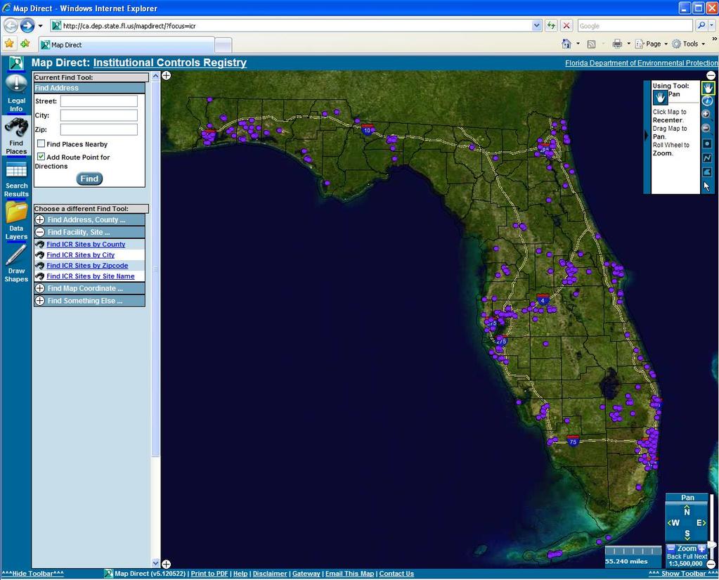
10
11 How do you use the ICR Web Viewer Tools? Mouse Controls You can use the mouse to navigate the map in a variety of ways. Basic Mouse Controls Pan the map by dragging the mouse with the left mouse button held down. Identify features by left clicking on the map. Zoom in one level of detail so the map shows more detail (but less area) Zoom out one level of detail so the map shows more area (but less detail) Draw Points Double Click Map to Add as Markup. Draw Line Double Click Map to Add as Markup. Draw Polygon Double Click Map to Add as Markup. Select features by left clicking on the map. Note: A Markup tool provides a user the abilty to add points, line and polygons to the map.
12 How to use the Zoom Tools? In the ICR web application, detailed layers (like local roads) are automatically activated and labeled, depending upon the extent of your zoom

13 Note: To Zoom in or Zoom out left click and hold down on the map and drag the red b ox to desired area

14 Note: To Identify a site click on the desired site and an information screen will open.

15 How to view the Result Table? After selecting a new site with the identify Tool the Result Table will popup automatically From the results table you will find important information regarding this site. Next click on the link to access these sites below: Florida Institutional Controls Registry this link is to the Metadata Open report this report shows the results for the site s Control(s) and Mechanism. OCULUS Documents this links you to the site s document(s)


16 This is what displays by clicking on each hyperlinks. Florida Institutional Controls Registry this is the Metadata Result Open report this is the results for the site s Control(s) and Mechanism. OCULUS Documents link displays the list of documents currently available to view online. document(s)
17 How to find a site in the registry? The approach more likely to be taken when seeking sites within the registry is the Search method There are several methods for searching: search by county, city, zip code, or Site name Each search method is represented by a tool on the toolbar Each search tool basically works the same

18 How to search by county?? First select the Find Places button Second - click on the Find ICR Sites by County Third - select a County

19 How to search by county? The Find ICR Sites by County tool allows you to choose a county from the drop-down list on the right You can also type the first letter of the county to scroll to the selection Note: Follow the same steps to search by City, Zip or Site Name.
20 How to see all selected sites within a county? Select the Search Results button Here you can review all the ICR sites within the county you have selected.

21 Search Results Note: Follow the same steps to search results by City, Zip or Site Name.
22 How to add new sites to the registry? Review online Procedures Guidance documentation blications/wc/csf/icpg.pdf ICR Data Sheet ations/wc/csf/icpg.pdf ICR address:

23 What site information is needed?

24 Who to contact with questions? Chris Williams Division of Waste Management Phone: (850)
Map Direct Lite. Quick Start Guide: Map Layers 5/14/2018
 Map Direct Lite Quick Start Guide: Map Layers 5/14/2018 Contents Quick Start Guide: Map Layers... 1 Map Layers in Map Direct Lite.... 3 What is a Basemap Layer?... 4 Change the Basemap Using the Basemap
Go SOLAR Online Permitting System A Guide for Applicants November 2012
 Go SOLAR Online Permitting System A Guide for Applicants November 2012 www.broward.org/gogreen/gosolar Disclaimer This guide was prepared as an account of work sponsored by the United States Department
Map Direct Lite. Contents. Quick Start Guide: Map Navigation 8/17/2015
 Map Direct Lite Quick Start Guide: Map Navigation 8/17/2015 Contents Quick Start Guide: Map Navigation... 1 Map Navigation in Map Direct Lite.... 2 Pan the Map by Dragging It.... 3 Zoom the Map In by Dragging
RAPIDMAP Geocortex HTML5 Viewer Manual
 RAPIDMAP Geocortex HTML5 Viewer Manual This site was developed using the evolving HTML5 web standard and should work in most modern browsers including IE, Safari, Chrome and Firefox. Even though it was
Welcome to the Lebanon County ArcGIS Online Property Viewer User Guide
 Welcome to the Lebanon County ArcGIS Online Property Viewer User Guide GIS stands for Geographic Information Systems. It is a computer system utilized for capturing, storing, and displaying data in relation
Currituck County GIS Online Mapping. User Instructions and Reference Guide
 Currituck County GIS Online Mapping User Instructions and Reference Guide JANUARY 2019 The Currituck County GIS Online Mapping website is designed to provide basic information to the general public about
How to use the New St. Mary s County s Zoning Map Viewer
 How to use the New St. Mary s County s Zoning Map Viewer You must turn off any pop-up blocking in your web- browser for the tools to work effectively in this mapping application. The New Zoning Map Viewer
The State of Missouri
 NASCIO 2013 Recognition Awards Nomination The State of Missouri Hazardous Substance Site Locator Project Initiation and Completion Dates: 04/29/13 to 12/01/13 Category: Digital Government: Government to
Welcome, please click on the hyperlink below to be directed to Sacramento County Online Maps. Survey's GIS Online Map
 Welcome, please click on the hyperlink below to be directed to Sacramento County Online Maps. Survey's GIS Online Map If the link does not work copy and paste the following address into your browser address
The Regional Climate Model Viewer
 Introduction The Regional Climate Model viewer provides access to Regional Climate Model weather variables averaged by calendar month for a selection of time slices. The Regional Climate Model viewer has
How to do a Property Search
 How to do a Property Search A Self-Tutorial GIS Services 1401 Marina Way South Richmond, CA 94804 Tel: (510) 621-1298 Fax: (510) 307-8116 1. Navigate to the GIS Mapping Services page. 2. The mapping services
The City of Huntsville, Texas GIS Mapping System
 The City of Huntsville, Texas GIS Mapping System Author: Huntsville, Texas GIS Division GIS DATA & MAP DISCLAIMER: The City of Huntsville, Texas shall not be held liable for improper or incorrect use of
City of La Crosse Online Mapping Website Help Document
 City of La Crosse Online Mapping Website Help Document This document was created to assist in using the new City of La Crosse online mapping sites. When the website is first opened, a map showing the City
Development Authority of the North Country (DANC) Internet Mapping Application Instructions Public Viewer 1. Purpose. 2. Logging-in. 3.
 Internet Mapping Application Instructions Public Viewer 1. Purpose. 2. Logging-in. 3.") Development Authority of the North Country (DANC) Internet Mapping Application Instructions Public Viewer 1. Purpose The purpose of this document is to outline basic functionality of the DANC Internet
Development Authority of the North Country (DANC) Internet Mapping Application Instructions Public Viewer 1. Purpose The purpose of this document is to outline basic functionality of the DANC Internet
LeeSpInS 2.0 Help Guide
 LeeSpInS 2.0 Help Guide http://leegis.leegov.com/leespins/ E-mail us at gis@leegov.com with any questions or issues using this site Navigation Tools Pan arrows scroll the map in the arrow direction or
And now the water system should be displayed:
 Webmap Tutorial Last updated: October 14, 2016 To Use the Web map: Open internet browser a. Type in the URL address: i. http://70.167.59.150/internal ii. Save in Favorites tab b. Note: This should work
St. Joseph County. GIS Department FetchGIS Web Map Tutorial
 St. Joseph County GIS Department FetchGIS Web Map Tutorial 2 Table of Contents Contents Slide #(s) Where to Find the Web Map 3 Disclaimer 4 Turning On and Off Map Layers 5 Searching for Parcels 6 More
This document does not represent a commitment to implement any portion of this specification in any company s products.
 Copyright Notice Copyright 2003 York University The companies and organizations listed above have granted the Open GIS Consortium, Inc. (OGC) a nonexclusive, royalty-free, paid up, worldwide license to
Oracle Utilities Work and Asset Management
 Oracle GIS Viewer Oracle Utilities Work and Asset Management Oracle GIS Viewer User Guide Release 1.9.1.1 E39486-03 December 2013 Oracle Utilities Work and Asset Management Oracle GIS Viewer User Guide,
User Guide for. Logical. Creating a Regional Decision Support System for the Houston-Galveston Region
 User Guide for Logical Creating a Regional Decision Support System for the Houston-Galveston Region Eco-Logical User Guide The Eco-Logical GIS is a free, online decision-making mapping tool that can be
Guide to Mapping Website (Public) December 2016 GC_236594
 December 2016 GC_236594") Guide to Mapping Website (Public) December 2016 GC_236594 Table of Contents Guide to Mapping Website (Public)... 1 December 2016... 1 Quick Start... 3 Map Layers... 4 How do I?... 5 Draw on the Map...
Guide to Mapping Website (Public) December 2016 GC_236594 Table of Contents Guide to Mapping Website (Public)... 1 December 2016... 1 Quick Start... 3 Map Layers... 4 How do I?... 5 Draw on the Map...
Getting Started with the new GIS Map Service Overview:
 Getting Started with the new GIS Map Service Overview: 1. Layer List Widget Shows all available layers. This widget will be open by default. 2. Legend Widget Gives symbology information for all visible
COMMISSION OF TEXAS MAY
 GIS Viewer RAILROAD COMMISSION OF TEXAS MAY 2017 Table of Contents GIS Viewer Basics... 1 Basics... 1 Screen Overview... 2 Tools... 5 Visibility... 5 Measure Tool... 7 Identify Tool... 10 Coordinates Tool...
HCA ArcGIS. Online Tool - How To Guide V1.0 2/15/2016 HAWAII CONSERVATION ALLIANCE AGOL
 HCA ArcGIS 2/15/2016 Online Tool - How To Guide V1.0 HAWAII CONSERVATION ALLIANCE AGOL Table of Contents What is ArcGIS Online?... 1 Getting Started... 1 Getting a Login... 1 Logging In... 2 Searching
Research drive Regina, Saskatchewan S4S 7J7. Field Book Retrieval Procedures
 c 00-0 Research drive Regina, Saskatchewan S4S 7J7 Field Book Retrieval Procedures May 7, 008 DISCLAIMER The materials in this training manual are for demonstration purposes only. The authorization forms
i-mapnj DEP Is there groundwater contamination on or near your farm?
 i-mapnj DEP Is there groundwater contamination on or near your farm? Using i-mapnj to find and measure distances to known contaminated sites on or near your farm Locate farm and contaminated sites 1) Start
How to use the DuPageMaps Interactive Web Mapping Application
 How to use the DuPageMaps Interactive Web Mapping Application Interactive Map Link: http://gis.dupageco.org/dupagemaps Helpful Information Initial View Find a parcel in DuPage County, Illinois Map Navigation
Fundisa Web Map Applications
 Fundisa Web Map Applications 2013-01-09 Prepared by SANSA Earth Observation 1 Using the SANSA Fundisa Web Map Applications The Fundisa web map applications were created to aid students in their search
Site Impact Policies for Website Use
 Site Impact Policies for Website Use Thank you for visiting the Site Impact website (the Website ). We have set up some ground rules to ensure protection of our rights and yours. Site Impact reserves the
Overview of CCSD Secure Cropper Map
 Overview of CCSD Secure Cropper Map Map Components: 1. Menu Options Use these menus to interact with the map. View School Zones: Use this menu to choose which school zone map to view. Select Students:
To show toolbars, double-click in the banner at the top or click the tools icon
 8/15/2013 Welcome to Culver City s GIS Property Information Search 2.0. This instructional document provides an overview of most commonly used functionality in this streamlined, enhanced web map application.
- Hold down the 'Shift' key and click and drag the mouse to create a red box which will zoom to that area when released.
 Basic navigation and zoom: To Pan around the map: - Click anywhere on the map and hold the button down until 4 directional arrows appear which will then allow the mouse to be moved in any direction panning
Handy dandy Guide to the Village of Lombard Interactive Maps
 Handy dandy Guide to the Village of Lombard Interactive Maps Hi Users! This is a brief guide to the GIS map application. These are made from the ESRI Flexviewer & we are continuing to research ways to
Greenville County Internet Mapping System User s Guide
 Greenville County Internet Mapping System User s Guide Version 2.0 Greenville County Geographic Information Systems May 30, 2006 Table of Contents NAVIGATING TO THE ONLINE MAPPING APPLICATIONS...- 3 -
Complete instructions for using the. Planners Map. in ArcGIS Online (
 Complete instructions for using the Planners Map in ArcGIS Online (www.arcgis.com) Overview of the Planners Map The Planners Map provides interested parties with information on tax parcels, shoreland zoning,
Viewing the Data 3 Turning Layers On / Off 4 Navigation Toolbar 5 Layout Toolbar 7 Identify Tool 8 Find Tool 10 Measure Tool 12 Go To XY Tool 14
 1 Viewing the Data 3 Turning Layers On / Off 4 Navigation Toolbar 5 Layout Toolbar 7 Identify Tool 8 Find Tool 10 Measure Tool 12 Go To XY Tool 14 Transparency Tool 16 Markup Tools 19 ArcMap Markup Tools
NJ-GeoWeb: Primer and Tutorial
 NJ-GeoWeb: Primer and Tutorial New Jersey Department of Environmental Protection Office of Information Resources Management Bureau of Geographic Information Systems PO Box 420 Mail Code 401-01 Trenton,
Installing Your Microsoft Access Database (Manual Installation Instructions)
") Installing Your Microsoft Access Database (Manual Installation Instructions) Installation and Setup Instructions... 1 Single User Setup... 1 Multiple User Setup... 2 Adjusting Microsoft Access 2003 Macro
Installing Your Microsoft Access Database (Manual Installation Instructions) Installation and Setup Instructions... 1 Single User Setup... 1 Multiple User Setup... 2 Adjusting Microsoft Access 2003 Macro
You may use the Service to either access, establish or change the following:
 Online Access Agreement June 18, 2015 (Revision date) I. Introduction This Online Access Agreement (this "Agreement") contains the terms that govern your use of the Participants' Private Area of the www.afmsagaftrafund.org
User Guide To CRITFC s Interactive Mappers
 User Guide To CRITFC s Interactive Mappers CRITFC is using ESRI products to build online interactive mapping applications for the display of general spatial and tabular data or for specific projects. The
OnCOR Silverlight Viewer Guide
 Getting Around There are many ways to move around the map! The simplest option is to use your mouse in the map area. If you hold the left button down, then click and drag, you can pan the map to a new
The Change Factor Viewer
 Introduction The Change Factor tool provides access to projections of the change between a baseline climate and the future climate by calendar month based on Regional Climate Model projections. The Change
Exercise 1: Getting to know ArcGIS
 The Scenario You are working for the California Visitor s Commission. You have been asked to prepare a map of California for several dignitaries from out of the country. Your map will need to include enough
ISV Map Site Tools. 21 March 2012 Page 1 of 5
 ISV Map Site Tools Upon initial load of the ISV Map Site, the Header bar, which displays Client specific details for the purpose of the site, slides down to reveal information. Then, after a short delay,
Chapter 1 : Getting Started with Integrity... Chapter 2 : Interface Layout... Chapter 3 : Navigation... Chapter 4 : Printing...
 .0 User s Manual Table of Contents Chapter : Getting Started with Integrity... Chapter : Interface Layout... Chapter : Navigation... Chapter : Printing... Chapter : Quick Search and Results Pane... Results
Map Direct Lite. Contents. Quick Start Guide: Sharing the Map 9/4/2015
 Map Direct Lite Quick Start Guide: Sharing the Map 9/4/2015 Contents Quick Start Guide: Sharing the Map... 1 Sharing Maps and Data in Map Direct Lite.... 2 Print Your Map to PDF.... 3 Share Your Map by
Map Central for Clients How to manual March 2016
 Map Central for Clients How to manual March 2016 Prepared by : Helena Nermut Suite 2, 1st Floor 120 Upper Heidelberg Road Ivanhoe VIC 3079 P: 61 3 9490 5400 F: 61 3 9497 2008 E: ausinfo@pfolsen.com www.pfolsen.com/au
SAGIS Property Map Viewer Instruction Manual Instructions for using the SAGIS Property Map Viewer. Published December 21, 2018.
 SAGIS Property Map Viewer Instruction Manual www.sagis.org/map Instructions for using the SAGIS Property Map Viewer. Published December 21, 2018. 1 Instructional Videos Click on a link to watch a video
Development of Web Applications for Savannah River Site
 STUDENT SUMMER INTERNSHIP TECHNICAL REPORT Development of Web Applications for Savannah River Site DOE-FIU SCIENCE & TECHNOLOGY WORKFORCE DEVELOPMENT PROGRAM Date submitted: October 17, 2014 Principal
Biodiversity Interactive Map
 Powered by MapShare Biodiversity Interactive Map (BIM) User Tips The Biodiversity Interactive Map (BIM) is accessible via the Department of Environment and Primary Industries (DEPI) website at www.depi.vic.gov.au.
Geocortex HTML 5 Viewer Manual
 Geocortex HTML 5 Viewer Manual Searching for a feature Use the Search Feature box in the top right hand corner of the viewer window. You can use this to search numerous data types such as property number,
Workshop 4 Installation INSTALL GUIDE. Document Date: February 4 th, Document Revision: 1.1
 INSTALL GUIDE Workshop 4 Installation Document Date: February 4 th, 2013 Document Revision: 1.1 Description This document describes how to install and configure Workshop 4, and how to install the driver
Georgia Online Disaster Awareness Geospatial System. Training Workbook
 Georgia Online Disaster Awareness Geospatial System Training Workbook Picture: Hurricane Irene, August 2011 For Training and Access Information Contact Planning/GIS (404) 635-7212 (404) 624-2636 https://godawgs.gema.ga.gov/gema2/
Please refer to for specifics and limitations with these operating systems.
 Appendix B ArcReader User Guide For the Southeast Ocean Based Renewable Energy Project INTRODUCTION The purpose of this document is to provide guidance and assistance to users with ArcReader, so that they
How To Guide for Using Maryland Incentive Zone Interactive Map
 How To Guide for Using Maryland Incentive Zone Interactive Map http://www.dhcd.state.md.us/gis/revitalize/index.html Purpose This How To guide is intended to: Determine if addresses are located within
Tutorial for Lane County Mapping Applications
 Tutorial for Lane County Mapping Applications Contents Overview... 2 Tools... 2 Navigation Tools... 3 Display Tools... 5 Information Tools... 6 Sharing Tools... 7 Common Tasks... 9 Identify or Show Data
Assessing Potential Seismic Risks of Indiana Urban Populations
 Assessing Potential Seismic Risks of Indiana Urban Populations (Student Handout) Introduction In this lesson you will learn how to use a geographic information systems (GIS) program (IndianaMap) to investigate
Oracle Utilities Work and Asset Management
 ESRI3 ArcGIS Viewer Oracle Utilities Work and Asset Management ESRI3 ArcGIS Viewer User Guide Release 1.9.1.2.5 July 2015 Oracle Utilities Work and Asset Management ESRI3 ArcGIS Viewer Guide - Release
Search Results Tabs. List Tab Options
 Search Results Tabs The Search Results screen is sectioned by tabs. These tabs contain information and tools that are vital in how you configure listing information to package and sell to your clients.
Waushara County Public Access Land Records Viewer Help
 Waushara County Public Access Land Records Viewer Help Main Screen Layout Overview Zoom Pan Controls Parcel Tools Tools Help and Links Image Layers Transition Tools Search Results from Parcel Search Tool
Butler County Property Ownership Website. Help Document
 Table of Contents Butler County Property Ownership Website Help Document Introduction... 1 Overview of Home Page... 1 Navigation & Tools... 2 Upper Right:...4 Layer List... 4 Draw... 4 Measurement... 6
Getting Started with VicMap
 Getting Started with VicMap This is a brief overview of some of the tools and features available on VicMap. At any time you can right click on the map and click Identify What s Here to find more information
PNDI Environmental Review Process
 Open the PA Natural Heritage Program website at http://www.naturalheritage.state.pa.us To access the PNDI Environmental Review tool, click the Conservation Explorer - PNDI Environmental Review link on
Climate-Smart New Orleans
 Climate-Smart New Orleans Table of Contents GETTING THERE... 2 Accessing the site... 2 Logging into the site... 2 Navigating the Map... 2 Zoom & Pan... 2 Change the map background... 3 Interacting in the
MAPLOGIC CORPORATION. GIS Software Solutions. Getting Started. With MapLogic Layout Manager
 MAPLOGIC CORPORATION GIS Software Solutions Getting Started With MapLogic Layout Manager Getting Started with MapLogic Layout Manager 2011 MapLogic Corporation All Rights Reserved 330 West Canton Ave.,
Clicking this icon will open the Layer list and will look something like this:
 Webmap Tutorial Last updated: November 17, 2015 To Use the Web map: Open internet browser a. Type in the URL address: i. http://arkcity.maps.arcgis.com/apps/webappviewer/index.html?id=22e0751b74f3411685160c7
Schedule 3 Background 3 What is ArchSite? 3 Introduction 3 ArchSite Viewer Options 4 Disclaimers 5 Creating a User Account 5 Working with the Public
 Introduction to ArchSite TABLE OF CONTENTS Schedule 3 Background 3 What is ArchSite? 3 Introduction 3 ArchSite Viewer Options 4 Disclaimers 5 Creating a User Account 5 Working with the Public View 6 Public
DATASHEET 4D SYSTEMS. 4D Raspberry Pi Serial Adaptor TURNING TECHNOLOGY INTO ART. 4D-Serial-Pi-Adaptor
 TURNING TECHNOLOGY INTO ART DATASHEET 4D-Serial-Pi-Adaptor Document Date: 20 th November 2012 Document Revision: 1.0 Uncontrolled Copy when printed or downloaded. Please refer to the 4D Systems website
Select the options to assess for this credit. Only one option can be selected if the rating system is set to Healthcare.
 Surrounding Density and Diverse Uses LT Surrounding Density and Diverse Uses Select options to assess: Select the options to assess for this credit. Only one option can be selected if the rating system
Each primary search has an auto-fill that will filter out results as the user continues to type.
 The Town of Farmville has recently requested a GIS parcel viewer and Timmons Group, based out of Richmond, VA, was selected to design and host this new website. This website allows users to look up parcel
Parkland County s Public Interactive Mapping Application USER MANUAL
 Parkland County s Public Interactive Mapping Application USER MANUAL Geographic Information Systems Discover Parkland v3.0 Updated: January 2017 Table of Contents I. Welcome to v3.0... 3 II. Discover Parkland
Basic Tasks in ArcGIS 10.3.x
 Basic Tasks in ArcGIS 10.3.x This guide provides instructions for performing a few basic tasks in ArcGIS 10.3.1, such as adding data to a map document, viewing and changing coordinate system information,
DATASHEET 4D SYSTEMS. 4D Arduino Adaptor Shield TURNING TECHNOLOGY INTO ART. 4Display-Adaptor-Shield
 TURNING TECHNOLOGY INTO ART DATASHEET 4Display-Adaptor-Shield Document Date: 20 th November 2012 Document Revision: 1.0 Uncontrolled Copy when printed or downloaded. Please refer to the 4D Systems website
Investigating Oil Production and Consumption with Web GIS Teacher Guide
 Web GIS Oil Teacher Handout Investigating Oil Production and Consumption with Web GIS Teacher Guide Crude oil (petroleum) was formed from the remains of tiny sea animals and plants that lived millions
Table of Contents. Map Layout... 5 Layer List - Default... 6 Identify... 7 Search Method... 8
 Table of Contents Map Layout... 5 Layer List - Default... 6 Identify... 7 Search Method... 8 1. Targeted Search... 8 2. Query Tool... 11 A. Select Parcel by entering Parcel Number... 12 B. Select Parcel
Read and accept the following disclaimer:
 How to use the Person County Tax Parcel Viewer Visit gis.personcounty.net and click to view the Tax Parcel Viewer or go to gis.personcounty.net/taxparcelviewer Read and accept the following disclaimer:
DATASHEET 4D SYSTEMS. 4D Raspberry Pi Serial Adaptor TURNING TECHNOLOGY INTO ART. 4D-Serial-Pi-Adaptor
 DATASHEET TURNING TECHNOLOGY INTO ART 4D Raspberry Pi Serial Adaptor 4D-Serial-Pi-Adaptor Document Date: 4 th September 2013 Document Revision: 1.1 Uncontrolled Copy when printed or downloaded. Please
TEI0005 TRM Revision: v.13 Exported on: 02/02/2018
 TEI0005 TRM Revision: v.13 Exported on: 02/02/2018 1 Table of Contents 1 Table of Contents... 2 2 Overview... 3 2.1 Key Features... 3 2.2 Block Diagram... 3 3 Signals, Interfaces and Pins... 4 3.1 Module
Greater Bridgeport Regional Council Municipal GIS Viewer Training April 2015
 Greater Bridgeport Regional Council Municipal GIS Viewer Training April 2015 GBRC GIS Web Training Table of Contents Introduction........................................................... 3 Viewer Components.......................................................
HikCentral Control Client. User Manual
 HikCentral Control Client User Manual Legal Information User Manual 2018 Hangzhou Hikvision Digital Technology Co., Ltd. About this Manual This Manual is subject to domestic and international copyright
in the help area and if you click on MapViewer.
 ARCTIC VIEWER INSTRUCTIONS The Arctic Viewer is an Internet mapping application built using ArcIMS by Environmental Systems Research institute (ESRI). The first time you use call up the viewer on your
AmpliFund Applicant User Guide
 AmpliFund Applicant User Guide Published by: Copyright 2017,, FL All rights reserved., Florida 214 North Hogan Street Jacksonville, FL 32202 Portions of the software described in this document copyright
DATASHEET 4D SYSTEMS. 4D Raspberry Pi Serial Adaptor TURNING TECHNOLOGY INTO ART. 4D-Serial-Pi-Adaptor
 DATASHEET TURNING TECHNOLOGY INTO ART 4D Raspberry Pi Serial Adaptor 4D-Serial-Pi-Adaptor Document Date: 21 st August 2014 Document Revision: 1.2 Uncontrolled Copy when printed or downloaded. Please refer
Notification of Regulated Waste Activity Using the MPCA s e-services Notification for hazardous waste activities
 www.pca.state.mn.us Notification of Regulated Waste Activity Using the MPCA s e-services Notification for hazardous waste activities Any business or government agency that generates, transports, or treats
Exercise 1: An Overview of ArcMap and ArcCatalog
 Exercise 1: An Overview of ArcMap and ArcCatalog Introduction: ArcGIS is an integrated collection of GIS software products for building a complete GIS. ArcGIS enables users to deploy GIS functionality
NMCRIS Map Service Application Prefield Query
 NMCRIS Map Service Application Prefield Query Exercise goal: As part of prefield activities conducted in advance of field investigations, this exercise instructs users to perform spatial queries of activities
Introduction to Microsoft Excel
 Chapter A spreadsheet is a computer program that turns the computer into a very powerful calculator. Headings and comments can be entered along with detailed formulas. The spreadsheet screen is divided
Crop Probability Map Tutorial
 Crop Probability Map Tutorial To be used in association with the CropProbabilityMap ArcReader document Prepared by Karen K. Kemp, PhD GISP, October 2012 This document provides a few key details about the
Market Intelligence Portal. User Guidance
 Market Intelligence Portal User Guidance Contents 1 Portal Interface... 2 1.1 Menu Bar... 2 1.2 Document Bar... 3 1.3 Filter Bar... 4 1.4 Document Viewer... 5 2 Viewing Documents... 6 3 Interacting with
Electronic Disclosure and Electronic Statement Agreement and Consent
 Electronic Disclosure and Electronic Statement Agreement and Consent Please read this "Electronic Disclosure and Electronic Statement Agreement and Consent" carefully and keep a copy for your records.
vippaq Main App. User Guide
 vippaq Main App. User Guide Edition 1d July 2008 Contents 1 INTRODUCTION 3 1.1 3 2 SYSTEM PREPARATION 4 2.1.1 Measuring Head Connection 5 2.1.2 Position the Measuring Heads 5 2.1.3 Start Job 5 3 MEASURE
13/02/2008. Users guide RoofCon Viewer
 Users guide RoofCon Viewer Table of contents Users guide RoofCon Viewer... 1 Table of contents... 2 Installation... 3 Select object... 3 Zoom... 3 Measure distance... 3 Toolbar and Drawing preferences...
Vizit Pro User Manual
 Vizit Pro User Manual 1 Table of Contents Vizit Pro User Manual... 1 Using Vizit Pro... 3 The Vizit Pro User Interface... 3 Toolbars... 4 File Tab Toolbar... 4 Edit Tab Toolbar... 5 Annotations Tab Toolbar...
Table of Contents Website Layout Website Tools
 Help Dialogue Welcome to the Vanderburgh County Assessor s Web Map! This website is a very useful resource for searching and research on properties within Vanderburgh County, Indiana. This help dialogue
MAP ASPEN Training Manual. Navigate back to City of Aspen Home, GIS Home, Map Aspen Home or the Data Catalog from any page in the site.
 Home Page Features: Top Navigation Bar MAP ASPEN Training Manual Navigate back to City of Aspen Home, GIS Home, Map Aspen Home or the Data Catalog from any page in the site. Search Bar Search for all content
Geography 281 Map Making with GIS Project Six: Labeling Map Features
 Geography 281 Map Making with GIS Project Six: Labeling Map Features In this activity, you will explore techniques for adding text to maps. As discussed in lecture, there are two aspects to using text
DIRECTORY OF FOREST PRODUCTS INDUSTRIES APPLICATION USER GUIDE
 DIRECTORY OF FOREST PRODUCTS INDUSTRIES APPLICATION USER GUIDE Directory of Forest Products Industries Table of Contents 1 ABOUT THE DIRECTORY OF FOREST PRODUCTS INDUSTRIES... 4 1.1 ACCESSING THE DIRECTORY.
COGCC GIS Online Map Instructions - Internet Site April 10, 2018
 COGCC GIS Online Map Instructions - Internet Site April 10, 2018 Table of Contents Page Section Page Section 1 Introduction 8 Clear Selection 2 Double Click 8 Buffer 3 Arrow Tip Information 9 Select within
Arizona State University Police Department Request for Proposals #: CAD/RMS/Mobile. Mapping Functional Requirements
 Geofile Administration Map Data Map Functionality Map Navigation Item # Mapping S M A U Comments 1 Geofile Administration Ability to accommodate an unlimited number of map layers (if the 2 number of layers
Denver Manufacturing Map Tool User Guide
 Denver Manufacturing Map Tool User Guide www.denvergov.org/oed Last update: March 15, 2016 Manufacturing in Denver With over 20,000 employees and nearly 1,000 businesses, Denver s manufacturing sector