Satellite surveying. Presentation for ISCWSA. Over 550 global PhotoSat stereo satellite topographic mapping projects.
|
|
|
- Logan Clifford Park
- 6 years ago
- Views:
Transcription

1 Satellite surveying Presentation for ISCWSA Over 550 global PhotoSat stereo satellite topographic mapping projects
2 Basic proposition Satellite surveying has improved to a level where it may be used as an alternative to ground surveying or airborne LiDAR for onshore oil and gas projects. Satellite surveying is useful for detecting and correcting gross survey errors. Uncertainty in surveying causes delays at many phases of oil and gas projects. A study of a typical onshore project shows that higher accuracy surveying earlier in the project greatly reduces delays.
3 Agenda Introduction to Satellite surveying Validating accuracy Real world examples Evaluating the value of surveying
4 Introduction to satellite surveying technology


5 Four key technical components enabling elevation mapping from space High resolution stereo satellite photos Adaptation of seismic processing systems Graphics Processing Units (GPUs) Oil Sands surveying Characterize the satellites and optimize the process
6 PhotoSat Algorithms Based on Seismic algorithms Achieve 4x better accuracy when compared to conventional photogrammetric algorithms No image warping Can assess accuracy compared to ground control Consistent throughout the area Experience database can be incorporated Ft McMurray and other projects have allowed us to identify systematic errors. Ideal for GPU processing 20x better throughput Allows iteration during QC


7 Stereo satellite photos used to map topography


8 GeoEye Steeo Satellites High resolution stereo satellites DigitalGlobe Stereo Satellites IKONOS 1m colour 2004 WorldView-1 50cm greyscale 2008 GeoEye-1 50cm colour 2009 WorldView-2 50cm colour 2010 WorldView-3 30cm colour Aug 2014

9 High resolution stereo satellites ASTRIUM Pleiades 1A June 2012 ASTRIUM Pleiades 1B February 2013


10 Graphic Processing Units (GPUs) 3,072 parallel processors 4 gigabytes RAM 4 teraflop C program compiler GPUs perform numerical processing up to 1000 times faster than CPUs. This enables us to do the hundreds of millions of 2D Fourier transforms necessary to automatically produce 1m Digital Surface Models from stereo satellite photos in reasonable times.


 USGS Choice of")
11 Testing the accuracy Two examples: Comparison to DGPS ground survey points 45,000 ground points in Eritrea Comparison to airborne LiDAR Garlock Fault USA NCALM data US National Digital Elevation Program (NDEP) USGS Choice of elevation check points
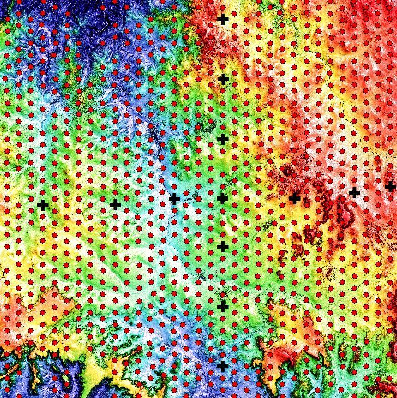
12 45,000 ground survey points in Asmara, Eritrea provided by Sunridge Gold.

13 45,000 ground survey points in Asmara, Eritrea provided by Sunridge Gold.

14 MWH Geophysics Survey Crew.


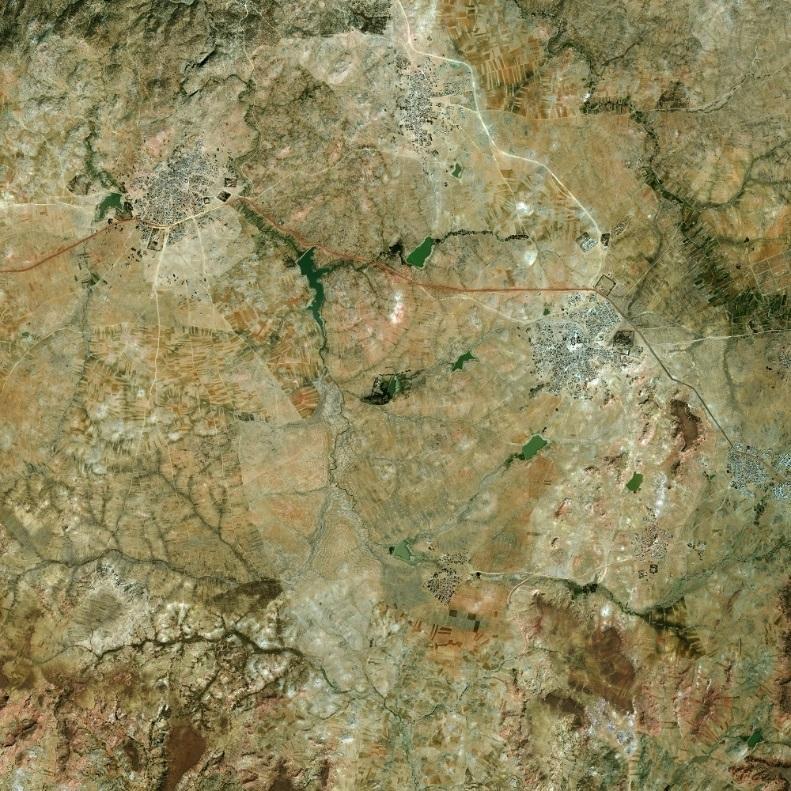

15 WorldView-2 DEM 100 km 2 Stereo WorldView-2 Asmara, Eritrea, June 2014

16 3D Ortho view


17 Z:\nas1\marketing\marketing_garlock_honda_track_wv3_accuracy_report_demo144\jpegs\jpegs_from_30cm_wv3 RMSE 15cm 10km x 10km area 14 ground control points 731 check points

18 PhotoSat accuracy study Location area of Open Topography LiDAR DEM. Garlock Fault, California.

19 LiDAR mapping from aircraft

20 WV 3 stereo satellite photo

21 10 km Open Topography LiDAR DTM. 5cm accuracy.

22 2.5km width CSH Lidar vs PhotoSat

23 500m width CSH Lidar vs PhotoSat


 If we")

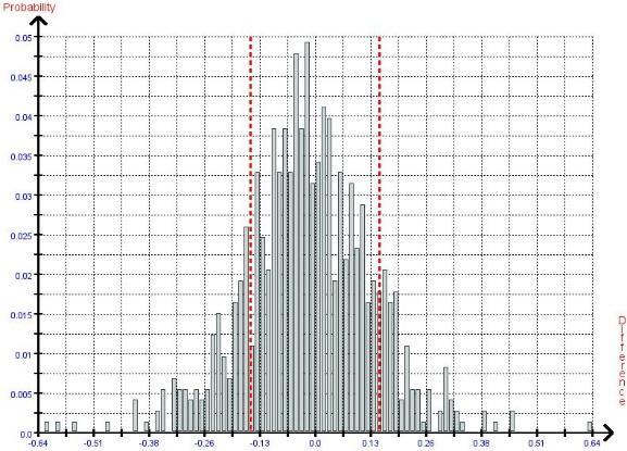
24 Garlock Fault, California Elevation differences between the PhotoSat WV3 and LiDAR topography. (in unchanged areas and slopes <20% grade) If we assume that the LiDAR is perfect then the RMS Linear error is less than 22cm
25 Examples of real world projects SADG Oil well heads Alberta Tobkana block, Kurdistan, Talisman Energy Reconciling multiple surveys Oil major Kurdistan Drillcollar mapping - Mexico

26 Pilot Program SAGD well site in Alberta


27 Case study SAGD well site in Alberta Pilot program for Producing SAGD well site In Alberta Canada Project started Jan 30 th 2015 Satellite images acquired February 4 th 2015 Processing complete February 6 th 2015
28 SAGD well site in Alberta Deliverables 100 sq km of satellite image data + orthophoto. Location of 70 well heads (excel + vectors) 1m elevation grid over well pad areas 50 cm contours Colour elevation image $12k USD Well head locations compared to Government of Alberta certified RTK surveying RMSE 11cm. Future program to compare this to low cost GPS surveying instrument.
29 Tobkana and Kurdamir Blocks Talisman Western Zagros Seismic planning and point correction

30 Stereo Satellite Topographic Mapping Tobkhana & Kurdamir Blocks Talisman, WesternZagros
31 28 km satellite topographic grid
32 28 km 2D seismic source points


33 Seismic source points elevation differences to satellite elevations

34 Kurdistan seismic source points differences to satellite elevations, SE points raised 1.3m Standard deviation 28cm.

35 107 seismic source points with greater than 1m elevation difference to satellite elevations. These are probably survey errors due to too few GPS satellites in range. These source point elevations should be replaced by the stereo satellite elevations.
36 Reconciling multiple data sets
37 Seismic Source points 13,730 points GPS3, 13,457 points GPS2, 4,040 points Well site GPS1 3,669 points

38 S GPS1, 3,669 points Offset to well survey 3.5m horizontal 0m elevation N GPS3, 13,457 points Offset to well survey 3.5m horizontal 1.0m elevation Well site GPS2, 4,040 points Offset to well survey 3.5m horizontal -2.15m elevation

39 S N Well site Seismic source points, 13,457 points Offset to well survey 3.5m horizontal 1.0m elevation

40 S N GPS1, 3,669 points GPS3, 13,457 points Well site GPS2, 4,040 points

41 S N Seismic source points, 13,457 points Well site
42 Assessing the impact of Surveying delays on Oil and Gas projects Most engineers agree that having accurate topographic survey data early in an Oil and Gas project reduces delays through-out the project. Despite this most projects commission multiple surveys with increasing levels of accuracy through-out the project life. PhotoSat has commissioned the development of a critical path model of a typical Oil and Gas project with the objective of quantifying delays caused by the multiple survey approach. This model was calibrated using actual client data for projects in Kurdistan.
43 Timeline for Kurdistan onshore Oil and Gas project

44 Detailed model 50+ activities identified, calibrated using projects in Kurdistan 1000 iteration Monte Carlo analysis to include effect of random errors Does not include catastrophic delays caused by errors in data Calculates delays does not quantify these into $
45 Phases of an onshore Oil and Gas project Each phase has 10+ activities some of which happen simultaneously.
46 Exploration drilling critical path
47 Drill collar location examples from Mining applications


48 Drill hole collar location errors identified with satellite mapping Survey errors Survey errors Drill holes on WV1 photo Drill holes on WV2 DEM

49 Drill hole collar coordinate mapping 750 Drill holes surveyed by three different survey contractors


50 Drill hole collar locations determined directly from stereo satellite mapping Drill hole collar 40cm x 40cm white concrete block White drill hole collar blocks on WV precision ortho

51 Drill hole collar coordinate mapping 40cm x 40cm white concrete block on satellite photo and the coordinates from the three GPS surveys

52 Drill hole collar coordinate mapping 40cm x 40cm white concrete blocks on satellite photo and the coordinates from the three GPS surveys.

53 Drill hole collar coordinate mapping Drill hole collar elevation differences between the GPS survey and the stereo satellite mapping

54 Drill hole collar coordinate mapping Drill hole collar elevation differences between the GPS survey and the stereo satellite mapping
55 Conclusions Satellite surveying has improved to a level where it may be used as an alternative to ground surveying or airborne LiDAR for onshore oil and gas projects. Satellite surveying is useful for detecting and correcting gross survey errors. Uncertainty in surveying causes delays in many phases of oil and gas projects. A study of a typical onshore project shows that higher accuracy surveying earlier in the project greatly reduces delays.
Over 15 PhotoSat Kurdistan stereo satellite topographic mapping projects
 Using highly accurate satellite topographic mapping to accelerate oil and gas projects in Kurdistan Over 15 PhotoSat Kurdistan stereo satellite topographic mapping projects Gerry Mitchell PhotoSat President
Generating 50cm elevation contours from space PhotoSat s s new stereo satellite elevation processing system
 Generating 50cm elevation contours from space PhotoSat s s new stereo satellite elevation processing system Gerry Mitchell PhotoSat November 2009 PhotoSat stereo satellite processing history PhotoSat has
UAV Surveying II. Precision. Accuracy. Reliability
 UAV Surveying II Precision. Accuracy. Reliability Part One: Project Lifecycle Deliverables Part Two: Evaluation of UAV Data Accuracy and Examples of Error Part Three: AGENDA Review of Results Examples
UAV Flight Operations for Mapping. Precision. Accuracy. Reliability
 UAV Flight Operations for Mapping Precision. Accuracy. Reliability Part One: Why is Mapping different? Part Two: What about accuracy and precision? Part Three: What is the Workflow? Part Four: AGENDA What
DIGITAL TERRAIN MODELS
 DIGITAL TERRAIN MODELS 1 Digital Terrain Models Dr. Mohsen Mostafa Hassan Badawy Remote Sensing Center GENERAL: A Digital Terrain Models (DTM) is defined as the digital representation of the spatial distribution
VALIDATION OF A NEW 30 METER GROUND SAMPLED GLOBAL DEM USING ICESAT LIDARA ELEVATION REFERENCE DATA
 VALIDATION OF A NEW 30 METER GROUND SAMPLED GLOBAL DEM USING ICESAT LIDARA ELEVATION REFERENCE DATA M. Lorraine Tighe Director, Geospatial Solutions Intermap Session: Photogrammetry & Image Processing
Scalability for Large Photogrammetry Projects
 Scalability for Large Photogrammetry Projects Dr. Philippe Simard President SimActive Inc. IMAGE About SimActive Founded in 2003, SimActive is the developer of Correlator3D software, a patented end-to-end
2/9/2016. Session Agenda: Implementing new Geospatial Technologies for more efficient data capture
 Implementing new Geospatial Technologies for more efficient data capture Jay Haskamp Applied Geospatial Engineer Steve Richter VP Sales Session Agenda: Today s changing technologies and what lies ahead
Accuracy Assessment of POS AVX 210 integrated with the Phase One ixu150
 White Paper 3/17/2016 Accuracy Assessment of POS AVX 210 integrated with the Phase One ixu150 Omer Mian, Joe Hutton, Greg Lipa, James Lutes, Damir Gumerov, Srdjan Sobol Applanix, William Chan - GeoPixel
2. POINT CLOUD DATA PROCESSING
 Point Cloud Generation from suas-mounted iphone Imagery: Performance Analysis A. D. Ladai, J. Miller Towill, Inc., 2300 Clayton Road, Suite 1200, Concord, CA 94520-2176, USA - (andras.ladai, jeffrey.miller)@towill.com
Overview of the Trimble TX5 Laser Scanner
 Overview of the Trimble TX5 Laser Scanner Trimble TX5 Revolutionary and versatile scanning solution Compact / Lightweight Efficient Economical Ease of Use Small and Compact Smallest and most compact 3D
Unmanned Aerial Systems: A Look Into UAS at ODOT
 Ohio Department of Transportation John R. Kasich, Governor Jerry Wray, Director Unmanned Aerial Systems: Tim Burkholder, PS Mapping Manager Division of Engineering Office of CADD and Mapping Services Kyle
Digital photogrammetry project with very high-resolution stereo pairs acquired by DigitalGlobe, Inc. satellite Worldview-2
 White PAPER Greater area of the City of La Paz, Bolivia Digital photogrammetry project with very high-resolution stereo pairs acquired by DigitalGlobe, Inc. satellite Worldview-2 By: Engineers Nelson Mattie,
SPOT-1 stereo images taken from different orbits with one month difference
 DSM Generation Almost all HR sensors are stereo capable. Some can produce even triplettes within the same strip (facilitating multi-image matching). Mostly SPOT (1-5) used for stereo and Ikonos (in spite
Quality Assurance and Quality Control Procedures for Survey-Grade Mobile Mapping Systems
 Quality Assurance and Quality Control Procedures for Survey-Grade Mobile Mapping Systems Latin America Geospatial Forum November, 2015 Agenda 1. Who is Teledyne Optech 2. The Lynx Mobile Mapper 3. Mobile
Applications of LiDAR in seismic acquisition and processing Mark Wagaman and Ron Sfara, Veritas DGC
 Applications of LiDAR in seismic acquisition and processing Mark Wagaman and Ron Sfara, Veritas DGC Abstract With its ability to provide accurate land surface elevations, the LiDAR (Light Detection And
Technical Considerations and Best Practices in Imagery and LiDAR Project Procurement
 Technical Considerations and Best Practices in Imagery and LiDAR Project Procurement Presented to the 2014 WV GIS Conference By Brad Arshat, CP, EIT Date: June 4, 2014 Project Accuracy A critical decision
LIDAR MAPPING FACT SHEET
 1. LIDAR THEORY What is lidar? Lidar is an acronym for light detection and ranging. In the mapping industry, this term is used to describe an airborne laser profiling system that produces location and
LiDAR data overview. Dr. Keiko Saito Global Facility for Disaster Reduction and Recovery (GFDRR)
") LiDAR data overview Dr. Keiko Saito Global Facility for Disaster Reduction and Recovery (GFDRR) LiDAR (Light Detecting And Ranging) 3D height profile Laser emitted from sensor onboard aircraft to measure
LiDAR data overview Dr. Keiko Saito Global Facility for Disaster Reduction and Recovery (GFDRR) LiDAR (Light Detecting And Ranging) 3D height profile Laser emitted from sensor onboard aircraft to measure
SPAR, ELMF 2013, Amsterdam. Laser Scanning on the UK Highways Agency Network. Hamish Grierson Blom Uk
 SPAR, ELMF 2013, Amsterdam Laser Scanning on the UK Highways Agency Network Hamish Grierson Blom Uk www.blomasa.com www.blom-uk.co.uk Blom UK Part of the Blom Group Blom Group - Europe s largest aerial
Accuracy Assessment of an ebee UAS Survey
 Accuracy Assessment of an ebee UAS Survey McCain McMurray, Remote Sensing Specialist mmcmurray@newfields.com July 2014 Accuracy Assessment of an ebee UAS Survey McCain McMurray Abstract The ebee unmanned
Improving wide-area DEMs through data fusion - chances and limits
 Improving wide-area DEMs through data fusion - chances and limits Konrad Schindler Photogrammetry and Remote Sensing, ETH Zürich How to get a DEM for your job? for small projects (or rich people) contract
Iowa Department of Transportation Office of Design. Photogrammetric Mapping Specifications
 Iowa Department of Transportation Office of Design Photogrammetric Mapping Specifications March 2015 1 Purpose of Manual These Specifications for Photogrammetric Mapping define the standards and general
Coastal Survey of archaeological sites using drones
 Coastal Survey of archaeological sites using drones In Poseidon s Realm XXI Underwater archaeology - interdisciplinary approaches and technical innovations Dimitrios Skarlatos, Savvidou Eleni Photogrammetric
LiDAR & Orthophoto Data Report
 LiDAR & Orthophoto Data Report Tofino Flood Plain Mapping Data collected and prepared for: District of Tofino, BC 121 3 rd Street Tofino, BC V0R 2Z0 Eagle Mapping Ltd. #201 2071 Kingsway Ave Port Coquitlam,
Digital Elevation Models
 Digital Elevation Models National Elevation Dataset 1 Data Sets US DEM series 7.5, 30, 1 o for conterminous US 7.5, 15 for Alaska US National Elevation Data (NED) GTOPO30 Global Land One-kilometer Base
Hamilton County Enhances GIS Base Mapping with 1-foot Contours
 Hamilton County Enhances GIS Base Mapping with 1-foot Contours Presented by Larry Stout, Hamilton County GIS Manager Brad Fugate, Woolpert Inc. Today s Presentation Hamilton County s 2004 Base Mapping
NATIONWIDE POINT CLOUDS AND 3D GEO- INFORMATION: CREATION AND MAINTENANCE GEORGE VOSSELMAN
 NATIONWIDE POINT CLOUDS AND 3D GEO- INFORMATION: CREATION AND MAINTENANCE GEORGE VOSSELMAN OVERVIEW National point clouds Airborne laser scanning in the Netherlands Quality control Developments in lidar
USE OF DRONE TECHNOLOGY AND PHOTOGRAMMETRY FOR BEACH MORPHODYNAMICS AND BREAKWATER MONITORING.
 Proceedings of the 6 th International Conference on the Application of Physical Modelling in Coastal and Port Engineering and Science (Coastlab16) Ottawa, Canada, May 10-13, 2016 Copyright : Creative Commons
Flood Risk Mapping with LIDAR
 Flood Risk Mapping with LIDAR Edward MacKinnon, AGRG June 16, 2004 University of Moncton Tim Webster, Project Supervisor Project Manager, Réal Daigle LIDAR Data (TERRA) Validation data (AGRG) Orthophotos
Sandy River, OR Bathymetric Lidar Project, 2012 Delivery QC Analysis Lidar QC Report March 26 th, 2013
 O R E G O N D E P A R T M E N T O F G E O L O G Y A N D M I N E R A L I N D U S T R I E S OLC Sandy River, OR Bathymetric Lidar Project Delivery Acceptance Report. Department of Geology & Mineral Industries
Central Coast LIDAR Project, 2011 Delivery 1 QC Analysis LIDAR QC Report February 17 th, 2012
 O R E G O N D E P A R T M E N T O F G E O L O G Y A N D M I N E R A L I N D U S T R I E S OLC Central Coast Delivery 1 Acceptance Report. Department of Geology & Mineral Industries 800 NE Oregon St, Suite
Trends in Digital Aerial Acquisition Systems
 Trends in Digital Aerial Acquisition Systems Ernest Yap Regional Sales Manager, Airborne-Americas eyap@applanix.com 1 Medium Format Digital Cameras Medium Format Digital Cameras Where does the Medium
2010 LiDAR Project. GIS User Group Meeting June 30, 2010
 2010 LiDAR Project GIS User Group Meeting June 30, 2010 LiDAR = Light Detection and Ranging Technology that utilizes lasers to determine the distance to an object or surface Measures the time delay between
Surpac Google Earth Tools
 Surpac Google Earth Tools Google Earth is a free software program that lets you fly anywhere on Earth to view satellite imagery, maps, terrain and 3D buildings. When used in conjunction with SURPAC, it
Terrain Modeling and Mapping for Telecom Network Installation Using Scanning Technology. Maziana Muhamad
 Terrain Modeling and Mapping for Telecom Network Installation Using Scanning Technology Maziana Muhamad Summarising LiDAR (Airborne Laser Scanning) LiDAR is a reliable survey technique, capable of: acquiring
Reality Check: Processing LiDAR Data. A story of data, more data and some more data
 Reality Check: Processing LiDAR Data A story of data, more data and some more data Red River of the North Red River of the North Red River of the North Red River of the North Introduction and Background
Wednesday, July 15, Author: Eldris Ferrer Gonzalez, M.Sc. Engineering CSA Group
 Twenty ninth Annual ESRI International User Conference Wednesday, July 15, 2009 Author: Eldris Ferrer Gonzalez, M.Sc. Engineering CSA Group Introduction to Valenciano Project LIDAR Survey for Valenciano
A SENSOR FUSION APPROACH TO COASTAL MAPPING
 A SENSOR FUSION APPROACH TO COASTAL MAPPING Maryellen Sault, NOAA, National Ocean Service, National Geodetic Survey Christopher Parrish, NOAA, National Ocean Service, National Geodetic Survey Stephen White,
PROBLEMS AND LIMITATIONS OF SATELLITE IMAGE ORIENTATION FOR DETERMINATION OF HEIGHT MODELS
 PROBLEMS AND LIMITATIONS OF SATELLITE IMAGE ORIENTATION FOR DETERMINATION OF HEIGHT MODELS K. Jacobsen Institute of Photogrammetry and GeoInformation, Leibniz University Hannover, Germany jacobsen@ipi.uni-hannover.de
Orthophotography and LiDAR Terrain Data Collection Rogue River, Oregon Final Report
 Orthophotography and LiDAR Terrain Data Collection Rogue River, Oregon Final Report Prepared by Sky Research, Inc. 445 Dead Indian Memorial Road Ashland, OR 97520 Prepared for Rogue Valley Council of Governments
Section 5 Orthoimage generation
 Section 5 Orthoimage generation Emmanuel Baltsavias Orthoimage Generation Older sensor models methods: Kratky s Polynomial Mapping Functions (PMFs) Relief corrected affine transformation - Project GCPs
Adrian Cosmin Ghimbaşan 1 Cornel Cristian Tereşneu 1 Iosif Vorovencii 1
 Adrian Cosmin Ghimbaşan 1 Cornel Cristian Tereşneu 1 Iosif Vorovencii 1 1 Forest Management Planning and Terrestrial Measurements Department, Faculty of Silviculture and Forest Engineering, Transilvania
ACCURACY COMPARISON OF VHR SYSTEMATIC-ORTHO SATELLITE IMAGERIES AGAINST VHR ORTHORECTIFIED IMAGERIES USING GCP
 ACCURACY COMPARISON OF VHR SYSTEMATIC-ORTHO SATELLITE IMAGERIES AGAINST VHR ORTHORECTIFIED IMAGERIES USING GCP E. Widyaningrum a, M. Fajari a, J. Octariady a * a Geospatial Information Agency (BIG), Cibinong,
Vegetation height maps derived from digital elevation models the next innovation in the production of orienteering maps?
 Vegetation height maps derived from digital elevation models the next innovation in the production of orienteering maps? Development of Orienteering Maps. 1. Revolution 20 years ago: Digital Cartography
Airborne LiDAR Surveys and Data Delivery in the Pipeline Industry
 Airborne LiDAR Surveys and Data Delivery in the Pipeline Industry Carlos Femmer Faron Olivier October 25, 2011 October 25, 2011 GITA GIS for Oil and Gas Pipeline 2011 Organization Fugro is a decentralized
AIRBORNE GEIGER MODE LIDAR - LATEST ADVANCEMENTS IN REMOTE SENSING APPLICATIONS RANDY RHOADS
 Place image here (10 x 3.5 ) AIRBORNE GEIGER MODE LIDAR - LATEST ADVANCEMENTS IN REMOTE SENSING APPLICATIONS RANDY RHOADS Geospatial Industry Manager HARRIS.COM #HARRISCORP Harris Company Information SECURITY
Airborne Laser Survey Systems: Technology and Applications
 Abstract Airborne Laser Survey Systems: Technology and Applications Guangping HE Lambda Tech International, Inc. 2323B Blue Mound RD., Waukesha, WI-53186, USA Email: he@lambdatech.com As mapping products
SimActive and PhaseOne Workflow case study. By François Riendeau and Dr. Yuri Raizman Revision 1.0
 SimActive and PhaseOne Workflow case study By François Riendeau and Dr. Yuri Raizman Revision 1.0 Contents 1. Introduction... 2 1.1. Simactive... 2 1.2. PhaseOne Industrial... 2 2. Testing Procedure...
Microwave. Infrared. Preprogrammed Chip
 Advanced Technology for Design Mapping and Construction Layout AACE A.A.C.E. Meeting August 5, 2009 Daniel K. Mardock RBF Consulting Survey Manager Registered Land Surveyor Certified Federal Surveyor Arizona
Municipal Projects in Cambridge Using a LiDAR Dataset. NEURISA Day 2012 Sturbridge, MA
 Municipal Projects in Cambridge Using a LiDAR Dataset NEURISA Day 2012 Sturbridge, MA October 15, 2012 Jeff Amero, GIS Manager, City of Cambridge Presentation Overview Background on the LiDAR dataset Solar
Onshore remote sensing applications: an overview
 Onshore remote sensing applications: an overview Dr. Richard Teeuw and Dr. Malcolm Whitworth School of Earth and Environmental Sciences, University of Portsmouth, UK. Overview Presentation on the applications
Combining Airborne LIDAR and Satellite RADAR for a Dynamic DEM. Ramon Hanssen, Delft University of Technology
 Combining Airborne LIDAR and Satellite RADAR for a Dynamic DEM Ramon Hanssen, Delft University of Technology 1 Release 27 September 2 Land surface elevation H(t) = H(t 0 ) + dh(dt) dt Elevation at time
NEXTMap World 30 Digital Surface Model
 NEXTMap World 30 Digital Surface Model Intermap Technologies, Inc. 8310 South Valley Highway, Suite 400 Englewood, CO 80112 083013v3 NEXTMap World 30 (top) provides an improvement in vertical accuracy
An Introduction to Lidar & Forestry May 2013
 An Introduction to Lidar & Forestry May 2013 Introduction to Lidar & Forestry Lidar technology Derivatives from point clouds Applied to forestry Publish & Share Futures Lidar Light Detection And Ranging
BLM Fire Project, 2013 QC Analysis Lidar and Orthophoto QC Report November 25th, 2013
 O R E G O N D E P A R T M E N T O F G E O L O G Y 1937 A N D M I N E R A L I N D U S T R I E S Department of Geology & Mineral Industries 800 NE Oregon St, Suite 965 Portland, OR 97232 BLM Fire Project,
Prepared for: CALIFORNIA COAST COMMISSION c/o Dr. Stephen Schroeter 45 Fremont Street, Suite 2000 San Francisco, CA
 REVIEW OF MULTIBEAM SONAR SURVEYS WHEELER REEF NORTH, SAN CLEMENTE, CALIFORNIA TO EVALUATE ACCURACY AND PRECISION OF REEF FOOTPRINT DETERMINATIONS AND CHANGES BETWEEN 2008 AND 2009 SURVEYS Prepared for:
Assessment of digital elevation models using RTK GPS
 Assessment of digital elevation models using RTK GPS Hsing-Chung Chang 1, Linlin Ge 2, Chris Rizos 3 School of Surveying and Spatial Information Systems University of New South Wales, Sydney, Australia
Burns, OR LIDAR Project, 2011 Delivery QC Analysis LIDAR QC Report February 13th, 2012
 O R E G O N D E P A R T M E N T O F G E O L O G Y A N D M I N E R A L I N D U S T R I E S OLC Burns, OR Delivery Acceptance Report. Department of Geology & Mineral Industries 800 NE Oregon St, Suite 965
Airborne Laser Scanning: Remote Sensing with LiDAR
 Airborne Laser Scanning: Remote Sensing with LiDAR ALS / LIDAR OUTLINE Laser remote sensing background Basic components of an ALS/LIDAR system Two distinct families of ALS systems Waveform Discrete Return
Corridor Survey of Both Existing and New to be Built Pipelines on Land Using LiDAR Scanning
 Corridor Survey of Both Existing and New to be Built Pipelines on Land Using LiDAR Scanning 1. Introduction For good monitoring and planning an onshore pipeline and to feed the Geographic Information System,
LiDAR Remote Sensing Data Collection: Yaquina and Elk Creek Watershed, Leaf-On Acquisition
 LiDAR Remote Sensing Data Collection: Yaquina and Elk Creek Watershed, Leaf-On Acquisition Submitted by: 4605 NE Fremont, Suite 211 Portland, Oregon 97213 April, 2006 Table of Contents LIGHT DETECTION
FIELD OPERATION CENTER Coastal Hydraulics Lab. Field Data Collection and Analysis Branch Our Team Members
 FIELD OPERATION CENTER Coastal Hydraulics Lab Field Data Collection and Analysis Branch Our Team Members Mobile/Static LIDAR and Photogrammetry Platforms and Equipment Mobile/Static LIDAR and Photogrammetry
Assimilation of Break line and LiDAR Data within ESRI s Terrain Data Structure (TDS) for creating a Multi-Resolution Terrain Model
 for creating a Multi-Resolution Terrain Model") Assimilation of Break line and LiDAR Data within ESRI s Terrain Data Structure (TDS) for creating a Multi-Resolution Terrain Model Tarig A. Ali Department of Civil Engineering American University of Sharjah,
Assimilation of Break line and LiDAR Data within ESRI s Terrain Data Structure (TDS) for creating a Multi-Resolution Terrain Model Tarig A. Ali Department of Civil Engineering American University of Sharjah,
BATHYMETRIC EXTRACTION USING WORLDVIEW-2 HIGH RESOLUTION IMAGES
 BATHYMETRIC EXTRACTION USING WORLDVIEW-2 HIGH RESOLUTION IMAGES M. Deidda a, G. Sanna a a DICAAR, Dept. of Civil and Environmental Engineering and Architecture. University of Cagliari, 09123 Cagliari,
Validating the digital terrain model.doc
 Title: Validating the digital terrain model Author(s): Jacques Populus (Ifremer) Document owner: Jacques Populus (jpopulus@ifremer.fr) Reviewed by: Roger Coggan (Cefas) Workgroup: MESH action: Action 2.2
Introduction Photogrammetry Photos light Gramma drawing Metron measure Basic Definition The art and science of obtaining reliable measurements by mean
 Photogrammetry Review Neil King King and Associates Testing is an art Introduction Read the question Re-Read Read The question What is being asked Answer what is being asked Be in the know Exercise the
Project Report Lower Columbia River. Report Presented to:
 December 29, 2005 Project Report Lower Columbia River Contract #2265-H Report Presented to: Puget Sound Lidar Consortium 1011 Western Avenue, Suite 500 Seattle, WA 98104 Phone: (206) 464-7090 Fax: (206)
Trimble Geospatial Division Integrated Solutions for Geomatics professions. Volker Zirn Regional Sales Representative
 Trimble Geospatial Division Integrated Solutions for Geomatics professions Volker Zirn Regional Sales Representative 1 Agenda Trimble GeoSpatial Division Airborne System Solutions Trimble Inpho Software
Performance Evaluation of Optech's ALTM 3100: Study on Geo-Referencing Accuracy
 Performance Evaluation of Optech's ALTM 3100: Study on Geo-Referencing Accuracy R. Valerie Ussyshkin, Brent Smith, Artur Fidera, Optech Incorporated BIOGRAPHIES Dr. R. Valerie Ussyshkin obtained a Ph.D.
Journal Online Jaringan COT POLIPD (JOJAPS) Accuracy Assessment of Height Coordinate Using Unmanned Aerial Vehicle Images Based On Leveling Height
 Accuracy Assessment of Height Coordinate Using Unmanned Aerial Vehicle Images Based On Leveling Height") JOJAPS eissn 2504-8457 Abstract Journal Online Jaringan COT POLIPD (JOJAPS) Accuracy Assessment of Height Coordinate Using Unmanned Aerial Vehicle Images Based On Leveling Height Syamsul Anuar Bin Abu
JOJAPS eissn 2504-8457 Abstract Journal Online Jaringan COT POLIPD (JOJAPS) Accuracy Assessment of Height Coordinate Using Unmanned Aerial Vehicle Images Based On Leveling Height Syamsul Anuar Bin Abu
PHOTOGRAMMETRIC SOLUTIONS OF NON-STANDARD PHOTOGRAMMETRIC BLOCKS INTRODUCTION
 PHOTOGRAMMETRIC SOLUTIONS OF NON-STANDARD PHOTOGRAMMETRIC BLOCKS Dor Yalon Co-Founder & CTO Icaros, Inc. ABSTRACT The use of small and medium format sensors for traditional photogrammetry presents a number
HIGH RESOLUTION DEMs AND ORTHO-IMAGE BASEMAPS FOR LOCAL GOVERNMENT APPLICATIONS
 HIGH RESOLUTION DEMs AND ORTHO-IMAGE BASEMAPS FOR LOCAL GOVERNMENT APPLICATIONS STATEMENT OF PROBLEM Digital Elevation Models (DEMs) are the digital representation of topographic and/or manmade features
QUALITY CONTROL METHOD FOR FILTERING IN AERIAL LIDAR SURVEY
 QUALITY CONTROL METHOD FOR FILTERING IN AERIAL LIDAR SURVEY Y. Yokoo a, *, T. Ooishi a, a Kokusai Kogyo CO., LTD.,Base Information Group, 2-24-1 Harumicho Fuchu-shi, Tokyo, 183-0057, JAPAN - (yasuhiro_yokoo,
An Overview of Applanix.
 An Overview of Applanix The Company The Industry Leader in Developing Aided Inertial Technology Founded on Canadian Aerospace and Defense Industry Expertise Providing Precise Position and Orientation Systems
Course Outline (1) #6 Data Acquisition for Built Environment. Fumio YAMAZAKI
 #6 Data Acquisition for Built Environment. Fumio YAMAZAKI") AT09.98 Applied GIS and Remote Sensing for Disaster Mitigation #6 Data Acquisition for Built Environment 9 October, 2002 Fumio YAMAZAKI yamazaki@ait.ac.th http://www.star.ait.ac.th/~yamazaki/ Course Outline
AT09.98 Applied GIS and Remote Sensing for Disaster Mitigation #6 Data Acquisition for Built Environment 9 October, 2002 Fumio YAMAZAKI yamazaki@ait.ac.th http://www.star.ait.ac.th/~yamazaki/ Course Outline
Alaska Department of Transportation Roads to Resources Project LiDAR & Imagery Quality Assurance Report Juneau Access South Corridor
 Alaska Department of Transportation Roads to Resources Project LiDAR & Imagery Quality Assurance Report Juneau Access South Corridor Written by Rick Guritz Alaska Satellite Facility Nov. 24, 2015 Contents
High Resolution Geomodeling, Ranking and Flow Simulation at SAGD Pad Scale
 High Resolution Geomodeling, Ranking and Flow Simulation at SAGD Pad Scale Chad T. Neufeld, Clayton V. Deutsch, C. Palmgren and T. B. Boyle Increasing computer power and improved reservoir simulation software
InSAR Operational and Processing Steps for DEM Generation
 InSAR Operational and Processing Steps for DEM Generation By F. I. Okeke Department of Geoinformatics and Surveying, University of Nigeria, Enugu Campus Tel: 2-80-5627286 Email:francisokeke@yahoo.com Promoting
Visualizing 2D Data in a 3D World
 Visualizing 2D Data in a 3D World Karl Kliparchuk, M.Sc., GISP, and Brendan Walashek, B.Sc. McElhanney Consulting Services Ltd. Email: kkliparchuk@mcelhanney.com and bwalashek@mcelhanney.com Agenda A Quick
AN INTEGRATED SENSOR ORIENTATION SYSTEM FOR AIRBORNE PHOTOGRAMMETRIC APPLICATIONS
 AN INTEGRATED SENSOR ORIENTATION SYSTEM FOR AIRBORNE PHOTOGRAMMETRIC APPLICATIONS M. J. Smith a, *, N. Kokkas a, D.W.G. Park b a Faculty of Engineering, The University of Nottingham, Innovation Park, Triumph
STARTING WITH DRONES. Data Collection and Remote Sensing with UAVs, etc. Dr. Bill Hazelton LS
 STARTING WITH DRONES Data Collection and Remote Sensing with UAVs, etc. Dr. Bill Hazelton LS What this Talk is About UAV-based data acquisition: What you need to get involved Processes in getting spatial
Terrestrial LiDAR. Patrick Crawford. Harnessing the Power of Big Data for Asset and Facility Management WHITE PAPER SHAFER, KLINE & WARREN
 WHITE PAPER Terrestrial LiDAR Harnessing the Power of Big Data for Asset and Facility Management Patrick Crawford Team Leader, Geospatial Systems SHAFER, KLINE & WARREN Executive Summary Terrestrial LiDAR
Lidar Talking Points Status of lidar collection in Pennsylvania Estimated cost and timeline
 Lidar Talking Points Pennsylvania has an immediate need for new lidar (topographic) data coverage. Some uses of the data are enumerated later in this document. USGS has calculated an average return on
2. AREAL PHOTOGRAPHS, SATELLITE IMAGES, & TOPOGRAPHIC MAPS
 LAST NAME (ALL IN CAPS): FIRST NAME: 2. AREAL PHOTOGRAPHS, SATELLITE IMAGES, & TOPOGRAPHIC MAPS Instructions: Refer to Exercise 3 in your Lab Manual on pages 47-64 to answer the questions in this work
LPS Project Manager User s Guide. November 2009
 LPS Project Manager User s Guide November 2009 Copyright 2009 ERDAS, Inc. All rights reserved. Printed in the United States of America. The information contained in this document is the exclusive property
Mobile LiDAR for Ground Applications. Spar 2006, March Paul Mrstik, Terrapoint Canada Inc. Craig Glennie, Terrapoint USA LLC
 Mobile LiDAR for Ground Applications Spar 2006, March 27 2006 Paul Mrstik, Terrapoint Canada Inc. Craig Glennie, Terrapoint USA LLC Agenda Introduction to Terrapoint What is mobile LiDAR? Advantages of
Aerial Triangulation Report 2016 City of Nanaimo Aerial Mapping Project
 Aerial Triangulation Report 2016 City of Nanaimo Aerial Mapping Project Project # 160001 Date: June 27, 2016 City of Nanaimo, 455 Wallace Street, Nanaimo, B.C., V9R 5J6 Attention: Mr. Mark Willoughby,
Files Used in this Tutorial
 Generate Point Clouds and DSM Tutorial This tutorial shows how to generate point clouds and a digital surface model (DSM) from IKONOS satellite stereo imagery. You will view the resulting point clouds
A Method to Create a Single Photon LiDAR based Hydro-flattened DEM
 A Method to Create a Single Photon LiDAR based Hydro-flattened DEM Sagar Deshpande 1 and Alper Yilmaz 2 1 Surveying Engineering, Ferris State University 2 Department of Civil, Environmental, and Geodetic
Lewis County Public Works Department (County) GIS Mapping Division 350 N. Market Blvd. Chehalis, WA Phone: Fax:
 GIS Mapping Division 350 N. Market Blvd. Chehalis, WA Phone: Fax:") March 31, 2005 Project Report Lewis County, WA Contract #2262-H Report Presented to: Lewis County Public Works Department (County) GIS Mapping Division 350 N. Market Blvd. Chehalis, WA 98532-2626 Phone:
March 31, 2005 Project Report Lewis County, WA Contract #2262-H Report Presented to: Lewis County Public Works Department (County) GIS Mapping Division 350 N. Market Blvd. Chehalis, WA 98532-2626 Phone:
Rogue River LIDAR Project, 2012 Delivery 1 QC Analysis LIDAR QC Report September 6 th, 2012
 O R E G O N D E P A R T M E N T O F G E O L O G Y A N D M I N E R A L I N D U S T R I E S OLC Rogue River Delivery 1 Acceptance Report. Department of Geology & Mineral Industries 800 NE Oregon St, Suite
Workshops funded by the Minnesota Environment and Natural Resources Trust Fund
 Workshops funded by the Minnesota Environment and Natural Resources Trust Fund Conservation Applications of LiDAR Data Workshops funded by: Minnesota Environment and Natural Resources Trust Fund Presented
UAS Campus Survey Project
 ARTICLE STUDENTS CAPTURING SPATIAL INFORMATION NEEDS UAS Campus Survey Project Texas A&M University- Corpus Christi, home to the largest geomatics undergraduate programme in Texas, USA, is currently undergoing
Airborne LiDAR Data Acquisition for Forestry Applications. Mischa Hey WSI (Corvallis, OR)
") Airborne LiDAR Data Acquisition for Forestry Applications Mischa Hey WSI (Corvallis, OR) WSI Services Corvallis, OR Airborne Mapping: Light Detection and Ranging (LiDAR) Thermal Infrared Imagery 4-Band
Airborne LiDAR Data Acquisition for Forestry Applications Mischa Hey WSI (Corvallis, OR) WSI Services Corvallis, OR Airborne Mapping: Light Detection and Ranging (LiDAR) Thermal Infrared Imagery 4-Band
Accuracy Assessment of Ames Stereo Pipeline Derived DEMs Using a Weighted Spatial Dependence Model
 Accuracy Assessment of Ames Stereo Pipeline Derived DEMs Using a Weighted Spatial Dependence Model Intro Problem Statement A successful lunar mission requires accurate, high resolution data products to
Tutorial 1: Downloading elevation data
 Tutorial 1: Downloading elevation data Objectives In this exercise you will learn how to acquire elevation data from the website OpenTopography.org, project the dataset into a UTM coordinate system, and
MODEL DEFORMATION ACCURACY OF DIGITAL FRAME CAMERAS
 MODEL DEFORMATION ACCURACY OF DIGITAL FRAME CAMERAS V. Spreckels a, A. Schlienkamp a, K. Jacobsen b a Deutsche Steinkohle AG (DSK), Dept. Geoinformation/Engineering Survey BG G, Shamrockring 1, D-44623
Contents of Lecture. Surface (Terrain) Data Models. Terrain Surface Representation. Sampling in Surface Model DEM
 Data Models. Terrain Surface Representation. Sampling in Surface Model DEM") Lecture 13: Advanced Data Models: Terrain mapping and Analysis Contents of Lecture Surface Data Models DEM GRID Model TIN Model Visibility Analysis Geography 373 Spring, 2006 Changjoo Kim 11/29/2006 1
Lecture 13: Advanced Data Models: Terrain mapping and Analysis Contents of Lecture Surface Data Models DEM GRID Model TIN Model Visibility Analysis Geography 373 Spring, 2006 Changjoo Kim 11/29/2006 1
N.J.P.L.S. An Introduction to LiDAR Concepts and Applications
 N.J.P.L.S. An Introduction to LiDAR Concepts and Applications Presentation Outline LIDAR Data Capture Advantages of Lidar Technology Basics Intensity and Multiple Returns Lidar Accuracy Airborne Laser