OBLIQUE AERIAL IMAGERY A REVIEW
|
|
|
- Polly Cross
- 6 years ago
- Views:
Transcription

 First recorded aerial photo in the US (1860) by J.W. Black and S. King in Boston (USA) was an oblique shot from a balloon In 1906 G. R.")
1 OBLIQUE AERIAL IMAGERY A REVIEW FABIO REMONDINO 3D Optical Metrology unit Bruno Kessler Foundation (FKB) Trento, Italy remondino@fbk.eu MARKUS GERKE EOS dept. ITC / Univ. Twente, Enschede, The Netherlands m.gerke@utwente.it Contents: History, concepts, sensors, data processing & applications EuroSDR questionnaire ISPRS / EuroSDR benchmark Conclusions & Outlook A look back..(1) First recorded aerial photo in the US (1860) by J.W. Black and S. King in Boston (USA) was an oblique shot from a balloon In 1906 G. R. Lawrence used between nine and seventeen large kites to lift a huge camera and take some oblique aerial images of San Francisco (USA) after the strong earthquake in the area Kites & balloon were then abandoned in favour of powered flight, which gained importance for military reconnaissance during World War I Source: Wikipedia Source:
 In the 1930 s USGS and militaries")


2 A look back..(2) In the 1930 s USGS and militaries systematically captured oblique images During WWII oblique were used for inspection and reconnaissance In the analogue times too expensive technology Almost 10 years ago: Pictometry system Nowadays different systems available A returned technology / system January to May 2014 issues of the GIM Int. magazine USGC-9 Zeiss twin RMK Zeiss KS-153 General classification of oblique digital cameras single swiping camera Oblique aerial imagery and cameras VisionMap


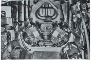

3 Oblique aerial imagery and cameras General classification of oblique digital cameras single swiping camera 2 cameras IGI Dual Zeiss twin RMK DiMAC Oblique aerial imagery and cameras General classification of oblique digital cameras single swiping camera 2 cameras 3 cameras DLR-3K 3x Jena LMK 3x Fairchild K-17 Bagley 3-lens (1920)

")
4 Oblique aerial imagery and cameras General classification of oblique digital cameras single swiping camera 2 cameras 3 cameras 4 cameras NPO KSI Zeiss (1930) Rolleimetric AIC x4 Oblique aerial imagery and cameras General classification of oblique digital cameras single swiping camera 2 cameras 3 cameras 4 cameras 5 cameras Leica RCD30 Fairchild T-3A (1930 s) Microsoft/Vexcel Osprey


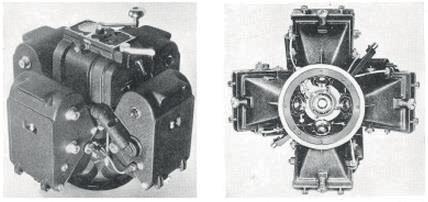
5 Oblique aerial imagery and cameras General classification of oblique digital cameras single swiping camera 2 cameras 3 cameras 4 cameras 5 cameras Multiple cameras NPO KSI Schiempflug (1904) 9-lens Fairchild Oblique aerial imagery and cameras Fan (static or sweeping) vs Maltese Cross configuration - IGI Dual Cam -A3 Visionmap - Track Air MIDAS - IGI Penta DigiCam - Hexagon/Leica RCD30 - Pictometry / BlomOblique - Microsoft/Vexcel Osprey


 Wide vs narrow angle lens Leica RCD30")

 Multiple views, including nadir Better interpretation (building")
 Higher redundancy & reliability 3D vs 2.")
6 Maltese Cross configuration Oblique aerial imagery and cameras One vertically pointing camera + 4 oblique cameras pointing to the four cardinal directions Modular (i.e. varying angles) vs fixed Small vs medium vs large format camera sensors RGB + NIR (in the nadir) Wide vs narrow angle lens Leica RCD30 Microsoft/Vexcel VERTICAL: good observation of roofs, constant scale, traditional approach OBLIQUE Pros / Benefits: Visibility of roofs as well as vertical structures (feature extraction, texturing, etc.) Multiple views, including nadir Better interpretation (building footprints, number of floors, etc.) Higher redundancy & reliability 3D vs 2.5D point clouds More detailed 3D city models Possibility to automatically produce true-ortho A lot of hidden potential OBLIQUE Cons: Oblique imagery Pros & Cons More occlusions (mitigated through multiple views and overlap) Varying scale / GSD


7 Applications Manual inspection Monoplotting / Building height measurements Detailed 3D city modeling Dense Matching Texturing Damage assessment Scene classification and interpretation (trees, facades, roofs, streets, etc.) complexity Source: Pictometry online Source: Blom / EENA Source: FBK Trento Monoplotting / Building height measurements Applications Source: BlomUrbex

")


8 Interactive city modeling (Imagemodeler + Blomoblique) Applications Source: Xiao, 2013 Applications Dense matching Source: Gerke, 2013 Source: Fritsch et al., 2012 Source: FBK Trento, 2014


9 Applications Automatic generation of 3D textured models Source: EADS Streetfactory / Astrium Damage assessment Applications Source: CGR / FBK
")
10 Applications Cadastral needs Number of floors Building footprints Data collection & processing State-of-the-art is 5 images for every acquisition position Large image block size (thousands of images) New issues / problems / challenges for flight planning Problems for traditional photogrammetric approaches: Convergent images Varying image scale / resolution (GCPs measured with different accuracy) Large perspective distortion (SIFT-like operator are less efficient) Long processing time
 and large (10m) streets Façades parallel to the flight direction High tilt angles (e.g. 45 deg) lead to inhomogeneous redundancy of points Smaller tilt angles (e.")


![233 246] Simulated AT Data collection & processing - Simulations Different camera configuration tested (small, medium, large; 60/40, 80/60, 80/80, 90/90) Run AT and](/docs-images/77/75121680/images/11-3.jpg "estimated std of objected coordinates The larger the overlap, the better the quality of object coordinates (and larger the redundancy) The higher the oblique angles,")
![the better the quality of objected coordinates sigma [m] High tilt angles and very large overlap lead to very good object coordinates and large redundancy Cost-Benefit](/docs-images/77/75121680/images/11-4.jpg "analysis [Rupnik, E., Nex, F., Toschi, I., Remondino, F. 233 246]")
11 Simulated flight plan Data collection & processing - Simulations Flight 80/60, Maltese-cross camera with 30deg and 45deg oblique cameras Urban area with 20m height buildings, narrow (5m) and large (10m) streets Façades parallel to the flight direction High tilt angles (e.g. 45 deg) lead to inhomogeneous redundancy of points Smaller tilt angles (e.g. 30 deg) lead to fewer but more uniform redundancies To fully exploit advantages of oblique cameras, the street s width and the building s height play a major role in planning a successful urban survey campaign The taller the city architecture the lower the camera incidence angle should be A right compromise should be found between the camera tilt setting, given focal length, sensor size, overlap and geometry of the surveyed area [Rupnik, E., Nex, F., Toschi, I., Remondino, F., 2015: Aerial multi-camera systems: Accuracy and block triangulation issues. ISPRS Journal of Photogrammetry and Remote Sensing, Vol. 101, pp ] Simulated AT Data collection & processing - Simulations Different camera configuration tested (small, medium, large; 60/40, 80/60, 80/80, 90/90) Run AT and estimated std of objected coordinates The larger the overlap, the better the quality of object coordinates (and larger the redundancy) The higher the oblique angles, the better the quality of objected coordinates sigma [m] High tilt angles and very large overlap lead to very good object coordinates and large redundancy Cost-Benefit analysis [Rupnik, E., Nex, F., Toschi, I., Remondino, F., 2015: Aerial multi-camera systems: Accuracy and block triangulation issues. ISPRS Journal of Photogrammetry and Remote Sensing, Vol. 101, pp ]


12 Data collection & processing - AT Advanced workflow for AT Rely on GNSS/INS data Create a connectivity map/graph Use constraints like: Overlap, Look direction, Min numb of extracted tie points Exploit large observations redundancy [Rupnik, E., Nex, F., Remondino, F., 2013: Automatic orientation of large blocks of oblique images. ISPRS Archives of the Photogrammetry, Remote Sensing and Spatial Information Sciences, ISPRS Hannover 2013] Dense Image Matching Data collection & processing - DIM Use connectivity map Prefer images with same looking direction [Rupnik, E., Nex, F., and Remondino, F., 2014: Oblique multi-camera systems - orientation and dense matching issues. ISPRS Archives of the Photogrammetry, Remote Sensing and Spatial Information Sciences, XL-3/W1, pp ]


![107-114] Dense image matching Data collection & processing - DIM Use connectivity map Prefer images with](/docs-images/77/75121680/images/13-2.jpg "same looking direction Point cloud filtering Merge multiple point clouds (from every looking direction) 1")
![view 2 views 4 views [Rupnik, E., Nex, F. 107-114]](/docs-images/77/75121680/images/13-3.jpg)
13 Data collection & processing - DIM Dense image matching Use connectivity map Prefer images with same looking direction Point cloud filtering to remove blunders in oblique views [Rupnik, E., Nex, F., and Remondino, F., 2014: Oblique multi-camera systems - orientation and dense matching issues. ISPRS Archives of the Photogrammetry, Remote Sensing and Spatial Information Sciences, XL-3/W1, pp ] Dense image matching Data collection & processing - DIM Use connectivity map Prefer images with same looking direction Point cloud filtering Merge multiple point clouds (from every looking direction) 1 view 2 views 4 views [Rupnik, E., Nex, F., and Remondino, F., 2014: Oblique multi-camera systems - orientation and dense matching issues. ISPRS Archives of the Photogrammetry, Remote Sensing and Spatial Information Sciences, XL-3/W1, pp ]
 ISPRS/EuroSDR")


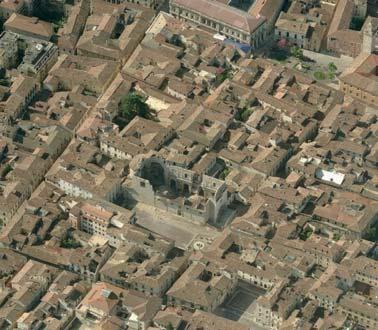
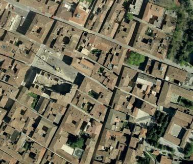
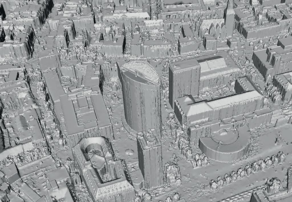
14 Dortmund dataset (IGI PentaCam) ISPRS/EuroSDR benchmark GSD 10cm > 1000 images Examples SURE dense point cloud Fabio Remondino - OBLIQUE SURE dense AERIAL point IMAGERY cloud A REVIEW

15

16 SURE true-orthophoto


17 Graz, Osprey camera, 10cm GSD Examples MicMac dense point cloud EuroSDR Questionnaire Questionnaire on the current status of oblique airborne imagery Run throughout participants About 10 questions, divided in users vs hw/sw producers Publication in the GIM International, Vol28(12), 2014


18 Best application with oblique imagery? Users: identification / mapping tasks have priority EuroSDR Questionnaire Vendors: Visualization Texturing of city modeling Interpretation What can oblique do better? EuroSDR Questionnaire

 ISPRS Scientific Initiative + EuroSDR co-founded activity Benchmark http://www2.isprs.")
 Fully automatic and reliable co-registration of multi platform/perspective imagery 2) Dense image matching within/across")

19 EuroSDR Questionnaire GSD and Stereo Overlap Q: What is the max allowed GSD at image centre (cm)? A: Mean 19cm, but majority in the 10cm range % 45% 40% 35% 30% 25% 20% 15% 10% Q: What is the desired min overlap? A: At least 60% (majority) 5% 0% at least 60% overlap (i.e. stereo) at least 70% at least 80% Multi-platform photogrammetry (initiated by F. Nex & M. Gerke) ISPRS Scientific Initiative + EuroSDR co-founded activity Benchmark Aims: 1) Fully automatic and reliable co-registration of multi platform/perspective imagery 2) Dense image matching within/across platforms terrestrial image blocks UAV (nadir/oblique) conventional airborne (nadir/oblique) [F. Nex, F., Gerke, M., Remondino, F., Przybilla, H.-J., Bäumker, M., Zurhorst, A., 2015: ISPRS benchmark for multiplatform photogrammetry. ISPRS Annals of the Photogrammetry, Remote Sensing and Spatial Information Sciences, Vol. II-3/W4, pp PIA15+HRIGI15 Joint ISPRS conference]
 only rotary wing TERRESTRIAL (3 selected buildings) GSD < 1cm (red area) REFERENCE DATA GNSS, total station TLS, ALS Benchmark Area1")
 rotary and wixed wing TERRESTRIAL (4 selected buildings) GSD < 1cm (red area) REFERENCE DATA GNSS, total station TLS, ALS Benchmark")
20 City center (Dortmund, Germany) OBLIQUE SYSTEM IGI PentaCam (80/80) GSD 10cm 1260 images (yellow area) UAV (3 selected buildings) oblique/nadir, GSD 1-2cm (red area) only rotary wing TERRESTRIAL (3 selected buildings) GSD < 1cm (red area) REFERENCE DATA GNSS, total station TLS, ALS Benchmark Area1 Zeche Zollern (Dortmund, Germany) OBLIQUE SYSTEM IGI PentaCam (80/80) GSD 10cm 910 images (yellow area) UAV (4 selected buildings) oblique/nadir, GSD 1-2cm (red area) rotary and wixed wing TERRESTRIAL (4 selected buildings) GSD < 1cm (red area) REFERENCE DATA GNSS, total station TLS, ALS Benchmark Area2
: Nadir-to-oblique pairs have 6times less tie points than nadirto-nadir pairs Only few matches across oblique viewing directions Self-calibration mandatory to reduce RMSE to 1 GSD (or better) In")
21 City center (Dortmund, Germany) Preliminary results (Pix4D & BLUH) Benchmark Area1: results Different configurations (overlap, GCP distribution, self calibration, etc.): Nadir-to-oblique pairs have 6times less tie points than nadirto-nadir pairs Only few matches across oblique viewing directions Self-calibration mandatory to reduce RMSE to 1 GSD (or better) In case of GCPs at the borders, always block deformation 80/80, in general, delivers better results than 60/60 Conclusions and outlook Oblique camera systems are definitely back and a promising solution for mapping purposes Different systems available but new systems might come out in the market soon Oblique airborne images will probably become a standard complementary to traditional large format nadir images Oblique will not replace traditional nadir acquisitions (maybe in urban areas?) Many possible applications: map update, 3D city modeling, inspection, interpretation, footprint identification, 3D cadastre, real estate, etc. NMCAs are slowly thinking to adjust their production pipeline to cope with obliques Oblique requires a new approach in the photogrammetric and production pipeline Data acquisition (flight plan) + Data processing (convergent, huge point clouds, etc.) + 3D restitution / Automated interpretation


22 Conclusions and outlook Additional costs of oblique flights (especially additional flight lines) might be compensated by additional outcomes and benefits: easier (or improved) object identification and readability of geographical information; generation of denser 3D point clouds, also on vertical elements; higher reliability with respect to traditional vertical acquisitions; measurement of heights, lengths and areas of features directly from the single images (improved monoplotting with 3D point cloud in background); quick generation of true-orthophotos; extension of traditional 2D GIS data; etc. Very dense, accurate and detailed point clouds but then? Conclusions and outlook New solutions to derive structured information out of unstructured point clouds Large polygonal models (e.g. GoogleEarth) are not useful if not only for visualization


")
23 Conclusions and outlook Some open research issues: scale and radiometric changes; correct and fast identification of homologues points, in particular across viewing directions; processing time; redundancy / overlap exploitation; fusion of point clouds coming from different viewing directions (and with different accuracy & resolution); automation in interpretation, especially for complex architectures etc. Concurrence / Competitor: UAV acquisitions? Conclusions and outlook BlomOblique Large area overview, details at 5-10 cm level on façades & buildings Point cloud (SURE) UAV Small area only, but details at cm level on façades & buildings and access unsafe areas
24 EuroSDR / ISPRS Workshop Ordnance Survey headquarter in Southampton (UK) Registration fee: free THANK YOU! FABIO REMONDINO 3D Optical Metrology unit Bruno Kessler Foundation (FKB) Trento, Italy remondino@fbk.eu MARKUS GERKE EOS dept. ITC / Univ. Twente, Enschede, The Netherlands m.gerke@utwente.it Acknowledgments: Francesco Nex (ITC/Univ. Twente), Karsten Jacobsen (LU Hannover), Konrad Wenzel (nframes), Ewelina Rupnik (IGN France), Isabella Toschi (FBK Trento)
OBLIQUE AERIAL IMAGES: POTENTIALITIES, APPLICATIONS AND BEST PRACTICES FRANCESCO NEX
 OBLIQUE AERIAL IMAGES: POTENTIALITIES, APPLICATIONS AND BEST PRACTICES FRANCESCO NEX f.nex@utwente.nl The history of oblique imagery First recorded aerial photo in the US (1860) by J.W. Black and S. King
OBLIQUE AERIAL IMAGERY FOR NMA SOME BEST PRACTICES
 OBLIQUE AERIAL IMAGERY FOR NMA SOME BEST PRACTICES F. Remondino 1, I. Toschi 1, M. Gerke 2, F. Nex 2, D. Holland 3, A. McGill 4, J. Talaya Lopez 5, A. Magarinos 5 1 3D Optical Metrology (3DOM) unit, Bruno
STATUS OF AIRBORNE OBLIQUE IMAGING EUROSDR COMMISSION I PROJECT OBLIQUE IMAGERY. Markus Gerke May 15, 2014
 STATUS OF AIRBORNE OBLIQUE IMAGING EUROSDR COMMISSION I PROJECT OBLIQUE IMAGERY Markus Gerke May 15, 2014 THE FIRST AIRBORNE PHOTOS WERE OBLIQUE First recorded aerial photograph in the US (Boston), by
THE ISPRS/EUROSDR BENCHMARK ON MULTI-PLATFORM PHOTOGRAMMETRY: RESULTS AND LESSON LEARNT FRANCESCO NEX AND MARKUS GERKE
 THE ISPRS/EUROSDR BENCHMARK ON MULTI-PLATFORM PHOTOGRAMMETRY: RESULTS AND LESSON LEARNT FRANCESCO NEX AND MARKUS GERKE Overview Summary of the results Statistics Data release What s next? ISPRS / EuroSDR
ISPRS Benchmark for Multi-Platform Photogrammetry
 ISPRS Benchmark for Multi-Platform Photogrammetry Francesco Nex (FBK) Markus Gerke (University of Twente/ITC) Fabio Remondino (FBK) Heinz-Jürgen Przybilla (HS Bochum) Manfred Bäumker (HS Bochum) Alexander
CURRENT DEVELOPMENTS IN AIRBORNE OBLIQUE IMAGING SYSTEMS AND AUTOMATED INTERPRETATION OF COMPLEX BUILDINGS. Markus Gerke
 CURRENT DEVELOPMENTS IN AIRBORNE OBLIQUE IMAGING SYSTEMS AND AUTOMATED INTERPRETATION OF COMPLEX BUILDINGS Markus Gerke THE FIRST AIRBORNE PHOTOS WERE OBLIQUE First recorded aerial photograph in the US
HIGH DENSITY AERIAL IMAGE MATCHING: STATE-OF-THE-ART AND FUTURE PROSPECTS
 HIGH DENSITY AERIAL IMAGE MATCHING: STATE-OF-THE-ART AND FUTURE PROSPECTS N. Haala a *, S. Cavegn a, b a Institute for Photogrammetry, University of Stuttgart, Germany - norbert.haala@ifp.uni-stuttgart.de
USE OF VERTICAL AERIAL IMAGES FOR SEMI-OBLIQUE MAPPING
 USE OF VERTICAL AERIAL IMAGES FOR SEMI-OBLIQUE MAPPING D. Poli a, K. Moe a, K. Legat b, I. Toschi b, F. Lago b, F. Remondino b a Terra Messflug GmbH, Eichenweg 42, 6460 Imst, Austria (k.moe, d.poli)@terra-messflug.at
REPORT OF THE SCIENTIFIC INITIATIVE
 Bruno Kessler Foundation (FBK) 3D Optical Metrology Unit (3DOM) Via Sommarive 18, Trento, Italy http://3dom.fbk.eu ISPRS BENCHMARK FOR MULTI-PLATFORM PHOTOGRAMMETRY REPORT OF THE SCIENTIFIC INITIATIVE
Oblique aerial photography viewer and monoplotting tool for building façade inspection and disaster assessment
 Oblique aerial photography viewer and monoplotting tool for building façade inspection and disaster assessment Arnadi Murtiyoso Department of Topography INSA Strasbourg, France arnadi.murtiyoso@insa-strasbourg.fr
1. Introduction. A CASE STUDY Dense Image Matching Using Oblique Imagery Towards All-in- One Photogrammetry
 Submitted to GIM International FEATURE A CASE STUDY Dense Image Matching Using Oblique Imagery Towards All-in- One Photogrammetry Dieter Fritsch 1, Jens Kremer 2, Albrecht Grimm 2, Mathias Rothermel 1
STATE-OF-THE-ART in DENSE IMAGE MATCHING
 STATE-OF-THE-ART in DENSE IMAGE MATCHING Fabio REMONDINO 3D Optical Metrology (3DOM) Bruno Kessler Foundation (FBK) Trento, Italy Email: remondino@fbk.eu http://3dom.fbk.eu Bruno Kessler Foundation (FBK)
Oblique aerial imagery in the praxis: applications and challenges
 ISPRS / EuroSDR Workshop on Oblique aerial cameras sensors and data processing Barcelona, 10 October 2017 Oblique aerial imagery in the praxis: applications and challenges Daniela Poli, Kjersti Moe, Klaus
POINT CLOUD ACQUISITION & STRUCTURING
 Point Cloud Processing 2018 March 13th, 2018 TU Delft, the Netherlands POINT CLOUD ACQUISITION & STRUCTURING Fabio REMONDINO 3D Optical Metrology (3DOM) Bruno Kessler Foundation (FBK) Trento, Italy Email:
Automated Processing for 3D Mosaic Generation, a Change of Paradigm
 Automated Processing for 3D Mosaic Generation, a Change of Paradigm Frank BIGNONE, Japan Key Words: 3D Urban Model, Street Imagery, Oblique imagery, Mobile Mapping System, Parallel processing, Digital
ACCURACY OF MEASUREMENTS IN OBLIQUE AERIAL IMAGES FOR URBAN ENVIRONMENT
 The International Archives of the Sciences, Volume XLII-2/W2, 2016 ACCURACY OF MEASUREMENTS IN OBLIQUE AERIAL IMAGES FOR URBAN ENVIRONMENT W. Ostrowski Department of Systems, Faculty of Geodesy and Cartography,
Segmentation of 3D Photogrammetric Point Cloud for 3D Building Modeling
 Segmentation of 3D Photogrammetric Point Cloud for 3D Building Modeling EMRE ÖZDEMİR 1,2, Fabio Remondino 1 1 3D Optical Metrology unit Bruno Kessler Foundation (FBK) Trento, Italy https://3dom.fbk.eu
Assessing the Performance of Different Direct-Georeferencing with Large Format Digital Cameras
 Assessing the Performance of Different Direct-Georeferencing with Large Format Digital Cameras Civil and Environment Engineering Department, Mu ta University, Mu ta, Al-Karak, Jordan, 61710. E.mail: khaldoun_q@hotamil.com
Oblique Image Processing in SURE - First Experiments and Results
 EuroSDR / ISPRS Workshop, Southampton 2015 Oblique Image Processing in SURE - First Experiments and Results Mathias Rothermel Outline» General Workflow» 2.5D Meshing» Mesh Texturing» 3D Workflow» First
THE USE OF UAVS FOR EARTH OBSERVATION FRANCESCO NEX
 THE USE OF UAVS FOR EARTH OBSERVATION FRANCESCO NEX f.nex@utwente.nl Overview Why UAVs for Earth Observation? Unmanned Aerial Vehicles classification Photogrammetric pipeline with UAVs Current applications
Image-based 3D Data Capture in Urban Scenarios
 Photogrammetric Week '15 Dieter Fritsch (Ed.) Wichmann/VDE Verlag, Belin & Offenbach, 2015 Haala, Rothermel 119 Image-based 3D Data Capture in Urban Scenarios Norbert Haala, Mathias Rothermel, Stuttgart
Automatic image network design leading to optimal image-based 3D models
 Automatic image network design leading to optimal image-based 3D models Enabling laymen to capture high quality 3D models of Cultural Heritage Bashar Alsadik & Markus Gerke, ITC, University of Twente,
3D recording of archaeological excavation
 5 th International Conference Remote Sensing in Archaeology The Age of Sensing 13-15 October 2014 - Duke University 3D recording of archaeological excavation Stefano Campana UNIVERSITY of CAMBRIDGE Faculty
The use of different data sets in 3-D modelling
 The use of different data sets in 3-D modelling Ahmed M. HAMRUNI June, 2014 Presentation outlines Introduction Aims and objectives Test site and data Technology: Pictometry and UltraCamD Results and analysis
UAV-BASED DAMAGE MAPPING AND THE FP7-PROJECT RECONASS
 UAV-BASED DAMAGE MAPPING AND THE FP7-PROJECT RECONASS Norman Kerle. ESA Department ITC-OOA-Group (with materials by Markus Gerke, Jorge Fernandez and Anand Vetrivel) ITC/ University Twente International
GEOMETRY AND INFORMATION CONTENTS OF LARGE SIZE DIGITAL FRAME CAMERAS
 GEOMETRY AND INFORMATION CONTENTS OF LARGE SIZE DIGITAL FRAME CAMERAS Karsten Jacobsen Institute of Photogrammetry and Geoinformation Leibniz University Hannover jacobsen@ipi.uni-hannover.de KEY WORDS:
PERFORMANCE OF LARGE-FORMAT DIGITAL CAMERAS
 PERFORMANCE OF LARGE-FORMAT DIGITAL CAMERAS K. Jacobsen Institute of Photogrammetry and GeoInformation, Leibniz University Hannover, Germany jacobsen@ipi.uni-hannover.de Inter-commission WG III/I KEY WORDS:
BUNDLE BLOCK ADJUSTMENT WITH HIGH RESOLUTION ULTRACAMD IMAGES
 BUNDLE BLOCK ADJUSTMENT WITH HIGH RESOLUTION ULTRACAMD IMAGES I. Baz*, G. Buyuksalih*, K. Jacobsen** * BIMTAS, Tophanelioglu Cad. ISKI Hizmet Binasi No:62 K.3-4 34460 Altunizade-Istanbul, Turkey gb@bimtas.com.tr
ifp Universität Stuttgart Performance of IGI AEROcontrol-IId GPS/Inertial System Final Report
 Universität Stuttgart Performance of IGI AEROcontrol-IId GPS/Inertial System Final Report Institute for Photogrammetry (ifp) University of Stuttgart ifp Geschwister-Scholl-Str. 24 D M. Cramer: Final report
THE INTERIOR AND EXTERIOR CALIBRATION FOR ULTRACAM D
 THE INTERIOR AND EXTERIOR CALIBRATION FOR ULTRACAM D K. S. Qtaishat, M. J. Smith, D. W. G. Park Civil and Environment Engineering Department, Mu ta, University, Mu ta, Karak, Jordan, 61710 khaldoun_q@hotamil.com
Mayden VP of Business Development Surdex Corporation
 Making Sense of Sensors Randy Mayden, Mayden VP of Business Development Surdex Corporation randym@surdex.com EARLYAERIAL PHOTOGRAPHY 2 FIRSTAERIAL CAMERA 3 AERIAL CAMERA SYSTEM DEVELOPMENT Aerial Camera
EVALUATION OF WORLDVIEW-1 STEREO SCENES AND RELATED 3D PRODUCTS
 EVALUATION OF WORLDVIEW-1 STEREO SCENES AND RELATED 3D PRODUCTS Daniela POLI, Kirsten WOLFF, Armin GRUEN Swiss Federal Institute of Technology Institute of Geodesy and Photogrammetry Wolfgang-Pauli-Strasse
Multi-ray photogrammetry: A rich dataset for the extraction of roof geometry for 3D reconstruction
 Multi-ray photogrammetry: A rich dataset for the extraction of roof geometry for 3D reconstruction Andrew McClune, Pauline Miller, Jon Mills Newcastle University David Holland Ordnance Survey Background
AUTOMATIC ORIENTATION OF LARGE BLOCKS OF OBLIQUE IMAGES
 AUTOMATIC ORIENTATION OF LARGE BLOCKS OF OBLIQUE IMAGES E. Rupnik a,, F. Nex b, F. Remondino b a GEO Department, Vienna University of Technology - ewelina.rupnik@geo.tuwien.ac.at b 3D Optical Metrology
Presented at the FIG Congress 2018, May 6-11, 2018 in Istanbul, Turkey
 Presented at the FIG Congress 2018, May 6-11, 2018 in Istanbul, Turkey Evangelos MALTEZOS, Charalabos IOANNIDIS, Anastasios DOULAMIS and Nikolaos DOULAMIS Laboratory of Photogrammetry, School of Rural
Sasanka Madawalagama Geoinformatics Center Asian Institute of Technology Thailand
 Sasanka Madawalagama Geoinformatics Center Asian Institute of Technology Thailand This learning material was not prepared by ADB. The views expressed in this document are the views of the author/s and
Reality Modeling Drone Capture Guide
 Reality Modeling Drone Capture Guide Discover the best practices for photo acquisition-leveraging drones to create 3D reality models with ContextCapture, Bentley s reality modeling software. Learn the
EVOLUTION OF POINT CLOUD
 Figure 1: Left and right images of a stereo pair and the disparity map (right) showing the differences of each pixel in the right and left image. (source: https://stackoverflow.com/questions/17607312/difference-between-disparity-map-and-disparity-image-in-stereo-matching)
Quality assessment of DIM on oblique images (preliminary results)
") FACULTY OF GEODESY AND CARTOGRAPHY W A R S A W U N I V E R S I T Y O F T E C H N O L O G Y Quality assessment of DIM on oblique images (preliminary results) Wojciech Ostrowski, Krzysztof Bakuła, Zdzisław
FACULTY OF GEODESY AND CARTOGRAPHY W A R S A W U N I V E R S I T Y O F T E C H N O L O G Y Quality assessment of DIM on oblique images (preliminary results) Wojciech Ostrowski, Krzysztof Bakuła, Zdzisław
PERFORMANCE ANALYSIS OF FAST AT FOR CORRIDOR AERIAL MAPPING
 PERFORMANCE ANALYSIS OF FAST AT FOR CORRIDOR AERIAL MAPPING M. Blázquez, I. Colomina Institute of Geomatics, Av. Carl Friedrich Gauss 11, Parc Mediterrani de la Tecnologia, Castelldefels, Spain marta.blazquez@ideg.es
Vexcel Imaging Ve V x e c x el e I l maging I G maging mbh www. wwwv. e v x e c x e c l e -limaging. - c imaging. om c
 Vexcel Imaging History 2016 MBO: becomes a privately owned company again 2006 Vexcel Imaging acquired by Microsoft Corp., Redmond/USA 2003 1992 1985 Merger of Vexcel Corp. & Vexcel Imaging 1 st Digital
INCORPORATING SCENE CONSTRAINTS INTO THE TRIANGULATION OF AIRBORNE OBLIQUE IMAGES
 INCORPORATING SCENE CONSTRAINTS INTO THE TRIANGULATION OF AIRBORNE OBLIQUE IMAGES M. Gerke and A.P. Nyaruhuma International Institute for Geo-Information Science and Earth Observation ITC, Department of
TRAINING MATERIAL HOW TO OPTIMIZE ACCURACY WITH CORRELATOR3D
 TRAINING MATERIAL WITH CORRELATOR3D Page2 Contents 1. UNDERSTANDING INPUT DATA REQUIREMENTS... 4 1.1 What is Aerial Triangulation?... 4 1.2 Recommended Flight Configuration... 4 1.3 Data Requirements for
2-in-1 Large Format and Oblique Aerial Camera Systems for 3D Urban Mapping. Philipp Grimm EUROSDR/ISPRS Workshop Oblique, Barcelona,
 2-in-1 Large Format and Oblique Aerial Camera Systems for 3D Urban Mapping Philipp Grimm EUROSDR/ISPRS Workshop Oblique, Barcelona, 09.10.2017 Mission Planning & Flight Guidance Sensor Management GNSS/IMU
The raycloud A Vision Beyond the Point Cloud
 The raycloud A Vision Beyond the Point Cloud Christoph STRECHA, Switzerland Key words: Photogrammetry, Aerial triangulation, Multi-view stereo, 3D vectorisation, Bundle Block Adjustment SUMMARY Measuring
MODEL DEFORMATION ACCURACY OF DIGITAL FRAME CAMERAS
 MODEL DEFORMATION ACCURACY OF DIGITAL FRAME CAMERAS V. Spreckels a, A. Schlienkamp a, K. Jacobsen b a Deutsche Steinkohle AG (DSK), Dept. Geoinformation/Engineering Survey BG G, Shamrockring 1, D-44623
DMC - Practical Experiences and Photogrammetric System Performance
 Photogrammetric Week '03 Dieter Fritsch (Ed.) Wichmann Verlag, Heidelberg, 2003 Dörstel 59 DMC - Practical Experiences and Photogrammetric System Performance CHRISTOPH DÖRSTEL, Z/I Imaging, Aalen ABSTRACT
Trimble VISION Positions from Pictures
 Trimble VISION Positions from Pictures This session will cover What Is Trimble VISION? Trimble VISION Portfolio What Do you Need? How Does It Work & How Accurate Is It? Applications Resources Trimble VISION
The Leica Geosystems CityMapper Solution
 Photogrammetric Week '13 Dieter Fritsch (Ed.) Wichmann/VDE Verlag, Belin & Offenbach, 2013 Wagner et al. 89 The Leica Geosystems CityMapper Solution RUEDIGER WAGNER, Heerbrugg, Switzerland PETER LIECKFELDT,
High resolution survey and orthophoto project of the Dosso-Gaya region in the Republic of Niger. by Tim Leary, Woolpert Inc.
 High resolution survey and orthophoto project of the Dosso-Gaya region in the Republic of Niger by Tim Leary, Woolpert Inc. Geospatial Solutions Photogrammetry & Remote Sensing LiDAR Professional Surveying
STARTING WITH DRONES. Data Collection and Remote Sensing with UAVs, etc. Dr. Bill Hazelton LS
 STARTING WITH DRONES Data Collection and Remote Sensing with UAVs, etc. Dr. Bill Hazelton LS What this Talk is About UAV-based data acquisition: What you need to get involved Processes in getting spatial
3D CITY MODELLING WITH CYBERCITY-MODELER
 1 3D CITY MODELLING WITH CYBERCITY-MODELER Kilian Ulm 1 and Daniela Poli 1 1. CyberCity AG, Zurich, Switzerland, (kilian.ulm, daniela.poli)@cybercity.tv ABSTRACT 3D city models using stereo aerial-/satellite
Leica ADS80 and Leica XPro - A total solution for photogrammetric mapping
 Leica ADS80 and Leica XPro - A total solution for photogrammetric mapping Ruedi Wagner, VP Imaging, Geospatial Solutions Division Phowo 2009 - Real Geospatial Solutions What else can I do with my sensor?
2. POINT CLOUD DATA PROCESSING
 Point Cloud Generation from suas-mounted iphone Imagery: Performance Analysis A. D. Ladai, J. Miller Towill, Inc., 2300 Clayton Road, Suite 1200, Concord, CA 94520-2176, USA - (andras.ladai, jeffrey.miller)@towill.com
Geometry of Aerial photogrammetry. Panu Srestasathiern, PhD. Researcher Geo-Informatics and Space Technology Development Agency (Public Organization)
") Geometry of Aerial photogrammetry Panu Srestasathiern, PhD. Researcher Geo-Informatics and Space Technology Development Agency (Public Organization) Image formation - Recap The geometry of imaging system
Geometry of Aerial photogrammetry Panu Srestasathiern, PhD. Researcher Geo-Informatics and Space Technology Development Agency (Public Organization) Image formation - Recap The geometry of imaging system
ISPRS Com1 Update Airborne Sensor Systems. Arthur Rohrbach SGPBF meeting, RSL, Fall 2006
 ISPRS Com1 Update Airborne Sensor Systems Arthur Rohrbach SGPBF meeting, RSL, Fall 2006 Significant Meetings / News (for Sensor Systems) 1/2 ASPRS, Reno, USA (May-06) Vexcel, Austria Leica, Switzerland
Introduction. Acute3D S.A.S. WTC Valbonne Sophia Antipolis. 120 route des Macarons.
 Introduction This benchmark compares the performances of the three main photo-based 3Dmodeling software. Five projects related to different kind of applications were led on the same machine and this document
DENSE 3D POINT CLOUD GENERATION FROM UAV IMAGES FROM IMAGE MATCHING AND GLOBAL OPTIMAZATION
 DENSE 3D POINT CLOUD GENERATION FROM UAV IMAGES FROM IMAGE MATCHING AND GLOBAL OPTIMAZATION S. Rhee a, T. Kim b * a 3DLabs Co. Ltd., 100 Inharo, Namgu, Incheon, Korea ahmkun@3dlabs.co.kr b Dept. of Geoinformatic
COMPARISON OF LASER SCANNING, PHOTOGRAMMETRY AND SfM-MVS PIPELINE APPLIED IN STRUCTURES AND ARTIFICIAL SURFACES
 COMPARISON OF LASER SCANNING, PHOTOGRAMMETRY AND SfM-MVS PIPELINE APPLIED IN STRUCTURES AND ARTIFICIAL SURFACES 2012 ISPRS Melbourne, Com III/4, S.Kiparissi Cyprus University of Technology 1 / 28 Structure
Quality Accuracy Professionalism
 GeoWing - who are we? Mapping Data Service Provider Lidar Multispectral Topographic and Planimetric Maps Elevation Models Point Clouds / 3D Models Orthophotography FAA-Authorized UAS Operators WOSB / DBE
Texturing Techniques in 3D City Modeling
 Texturing Techniques in 3D City Modeling 1 İdris Kahraman, 2 İsmail Rakıp Karaş, Faculty of Engineering, Department of Computer Engineering, Karabuk University, Turkey 1 idriskahraman@karabuk.edu.tr, 2
GENERATING BUILDING OUTLINES FROM TERRESTRIAL LASER SCANNING
 GENERATING BUILDING OUTLINES FROM TERRESTRIAL LASER SCANNING Shi Pu International Institute for Geo-information Science and Earth Observation (ITC), Hengelosestraat 99, P.O. Box 6, 7500 AA Enschede, The
New Features in SOCET SET Stewart Walker, San Diego, USA
 New Features in SOCET SET Stewart Walker, San Diego, USA 2610083107A EXPORT CONTROL DATA. This presentation is approved for export as of 31 August 2007. The actual product and its technical information
Multiray Photogrammetry and Dense Image. Photogrammetric Week Matching. Dense Image Matching - Application of SGM
 Norbert Haala Institut für Photogrammetrie Multiray Photogrammetry and Dense Image Photogrammetric Week 2011 Matching Dense Image Matching - Application of SGM p q d Base image Match image Parallax image
Cultural Heritage. Geometric Recording of Cultural Monuments. Basic Principles of Geometric Recording. Specific requirements
 LOW COST DIGITAL PHOTOGRAMMETRIC TECHNIQUES FOR THE DOCUMENTATION OF CULTURAL HERITAGE Ch. Ioannidis, S. Soile, C. Potsiou Lab. of Photogrammetry School of Rural & Surveying Eng. National Technical University
COMBINED BUNDLE BLOCK ADJUSTMENT VERSUS DIRECT SENSOR ORIENTATION ABSTRACT
 COMBINED BUNDLE BLOCK ADJUSTMENT VERSUS DIRECT SENSOR ORIENTATION Karsten Jacobsen Institute for Photogrammetry and Engineering Surveys University of Hannover Nienburger Str.1 D-30167 Hannover, Germany
DENSE MATCHING IN HIGH RESOLUTION OBLIQUE AIRBORNE IMAGES
 In: Stilla U, Rottensteiner F, Paparoditis N (Eds) CMRT09. IAPRS, Vol. XXXVIII, Part 3/W4 --- Paris, France, 3-4 September, 2009 DENSE MATCHING IN HIGH RESOLUTION OBLIQUE AIRBORNE IMAGES M. Gerke International
Overview of the Trimble TX5 Laser Scanner
 Overview of the Trimble TX5 Laser Scanner Trimble TX5 Revolutionary and versatile scanning solution Compact / Lightweight Efficient Economical Ease of Use Small and Compact Smallest and most compact 3D
Photogrammetry for forest inventory.
 Photogrammetry for forest inventory. Marc Pierrot Deseilligny. IGN/ENSG, France. Jonathan Lisein. Ulg Gembloux Agro-Bio Tech, Belgium. 1- Photogrammetry 2- Application to forestry 3- Tools and proposed
INTEGRATION OF MOBILE LASER SCANNING DATA WITH UAV IMAGERY FOR VERY HIGH RESOLUTION 3D CITY MODELING
 INTEGRATION OF MOBILE LASER SCANNING DATA WITH UAV IMAGERY FOR VERY HIGH RESOLUTION 3D CITY MODELING Xianfeng Huang 1,2 Armin Gruen 1, Rongjun Qin 1 Tangwu Du 1, Wei Fang 1 1 Singapore-ETH Center, Future
Calibration of IRS-1C PAN-camera
 Calibration of IRS-1C PAN-camera Karsten Jacobsen Institute for Photogrammetry and Engineering Surveys University of Hannover Germany Tel 0049 511 762 2485 Fax -2483 Email karsten@ipi.uni-hannover.de 1.
AUTOMATIC ROOF OUTLINES RECONSTRUCTION FROM PHOTOGRAMMETRIC DSM
 AUTOMATIC ROOF OUTLINES RECONSTRUCTION FROM PHOTOGRAMMETRIC DSM F. Nex, F. Remondino 3D Optical Metrology (3DOM) unit, Bruno Kessler Foundation (FBK), Trento, Italy @fbk.eu, http://3dom.fbk.eu
Photogrammetry: DTM Extraction & Editing
 Photogrammetry: DTM Extraction & Editing Review of terms Vertical aerial photograph Perspective center Exposure station Fiducial marks Principle point Air base (Exposure Station) Digital Photogrammetry:
Leica - Airborne Digital Sensors (ADS80, ALS60) Update / News in the context of Remote Sensing applications
 Update / News in the context of Remote Sensing applications") Luzern, Switzerland, acquired with GSD=5 cm, 2008. Leica - Airborne Digital Sensors (ADS80, ALS60) Update / News in the context of Remote Sensing applications Arthur Rohrbach, Sensor Sales Dir Europe,
Luzern, Switzerland, acquired with GSD=5 cm, 2008. Leica - Airborne Digital Sensors (ADS80, ALS60) Update / News in the context of Remote Sensing applications Arthur Rohrbach, Sensor Sales Dir Europe,
SimActive and PhaseOne Workflow case study. By François Riendeau and Dr. Yuri Raizman Revision 1.0
 SimActive and PhaseOne Workflow case study By François Riendeau and Dr. Yuri Raizman Revision 1.0 Contents 1. Introduction... 2 1.1. Simactive... 2 1.2. PhaseOne Industrial... 2 2. Testing Procedure...
Generating highly accurate 3D data using a sensefly exom drone
 Generating highly accurate 3D data using a sensefly exom drone C. Álvarez 1, A. Roze 2, A. Halter 3, L. Garcia 4 1 Geomatic Engineer, Lehmann Géomètre SA 2 Application Engineer, sensefly SA 3 Geomatic
Trends in Digital Aerial Acquisition Systems
 Trends in Digital Aerial Acquisition Systems Ernest Yap Regional Sales Manager, Airborne-Americas eyap@applanix.com 1 Medium Format Digital Cameras Medium Format Digital Cameras Where does the Medium
Trimble GeoSpatial Products
 Expanding Solutions for Photogrammetric and Remote Sensing Professionals 55 th Photogrammetric Week in Stuttgart September 7 th 2015 Tobias Heuchel, Trimble Stuttgart, Germany Trimble GeoSpatial Products
TRIMBLE BUSINESS CENTER PHOTOGRAMMETRY MODULE
 TRIMBLE BUSINESS CENTER PHOTOGRAMMETRY MODULE WHITE PAPER TRIMBLE GEOSPATIAL DIVISION WESTMINSTER, COLORADO, USA July 2013 ABSTRACT The newly released Trimble Business Center Photogrammetry Module is compatible
GABRIELE GUIDI, PHD POLITECNICO DI MILANO, ITALY VISITING SCHOLAR AT INDIANA UNIVERSITY NOV OCT D IMAGE FUSION
 GABRIELE GUIDI, PHD POLITECNICO DI MILANO, ITALY VISITING SCHOLAR AT INDIANA UNIVERSITY NOV 2017 - OCT 2018 3D IMAGE FUSION 3D IMAGE FUSION WHAT A 3D IMAGE IS? A cloud of 3D points collected from a 3D
Integrated Multi-Source LiDAR and Imagery
 Figure 1: AirDaC aerial scanning system Integrated Multi-Source LiDAR and Imagery The derived benefits of LiDAR scanning in the fields of engineering, surveying, and planning are well documented. It has
THE ETRUSCANS IN 3D: FROM SPACE TO UNDERGROUND
 THE ETRUSCANS IN 3D: FROM SPACE TO UNDERGROUND Fabio Remondino 1, Alessandro Rizzi 1, Belen Jimenez 1, Giorgio Agugiaro 1, Giorgio Baratti 1, Raffaele De Amicis 2 (1) 3D Optical Metrology (3DOM) Bruno
Drone2Map: an Introduction. October 2017
 Drone2Map: an Introduction October 2017 Drone2Map: An Introduction Topics: - Introduction to Drone Mapping - Coordinate Systems - Overview of Drone2Map - Basic Drone2Map Workflow - 2D Data Processing -
Photogrammetric Performance of an Ultra Light Weight Swinglet UAV
 Photogrammetric Performance of an Ultra Light Weight Swinglet UAV J. Vallet, F. Panissod, C. Strecha, M. Tracol UAV-g 2011 - Unmanned Aerial Vehicle in Geomatics September 14-16, 2011ETH Zurich Summary
INTERPRETING BUILDING FAÇADES FROM VERTICAL AERIAL IMAGES USING THE THIRD DIMENSION
 INTERPRETING BUILDING FAÇADES FROM VERTICAL AERIAL IMAGES USING THE THIRD DIMENSION Meixner P. and Leberl F. Institute for Computer Graphics and Vision, Graz University of Technology, Inffeldgasse 16/II,
ACCURATE ESTIMATION OF ORIENTATION PARAMETERS OF UAV IMAGES THROUGH IMAGE REGISTRATION WITH AERIAL OBLIQUE IMAGERY
 ACCURATE ESTIMATION OF ORIENTATION PARAMETERS OF UAV IMAGES THROUGH IMAGE REGISTRATION WITH AERIAL OBLIQUE IMAGERY F. A. Onyango *, F. Nex, M. S. Peter, P. Jende Dept. of Earth Observation Science, Faculty
DATA FUSION IN CULTURAL HERITAGE A REVIEW
 The International Archives of the Sciences, Volume XL-5/W7, 2015 DATA FUSION IN CULTURAL HERITAGE A REVIEW M. Magda Ramos, Fabio Remondino 3D Optical Metrology (3DOM) unit, Bruno Kessler Foundation (FBK),
Calibration and validation of digital airborne cameras
 Institut für Photogrammetrie ifp Calibration and validation of digital airborne cameras Michael Cramer Universität Stuttgart Institut für Photogrammetrie (ifp) Geschwister-Scholl-Str. 24D D-70174 Stuttgart
A New Protocol of CSI For The Royal Canadian Mounted Police
 A New Protocol of CSI For The Royal Canadian Mounted Police I. Introduction The Royal Canadian Mounted Police started using Unmanned Aerial Vehicles to help them with their work on collision and crime
Robust extraction of image correspondences exploiting the image scene geometry and approximate camera orientation
 Robust extraction of image correspondences exploiting the image scene geometry and approximate camera orientation Bashar Alsadik a,c, Fabio Remondino b, Fabio Menna b, Markus Gerke a, George Vosselman
Journal Online Jaringan COT POLIPD (JOJAPS) Accuracy Assessment of Height Coordinate Using Unmanned Aerial Vehicle Images Based On Leveling Height
 Accuracy Assessment of Height Coordinate Using Unmanned Aerial Vehicle Images Based On Leveling Height") JOJAPS eissn 2504-8457 Abstract Journal Online Jaringan COT POLIPD (JOJAPS) Accuracy Assessment of Height Coordinate Using Unmanned Aerial Vehicle Images Based On Leveling Height Syamsul Anuar Bin Abu
JOJAPS eissn 2504-8457 Abstract Journal Online Jaringan COT POLIPD (JOJAPS) Accuracy Assessment of Height Coordinate Using Unmanned Aerial Vehicle Images Based On Leveling Height Syamsul Anuar Bin Abu
Chapters 1 9: Overview
 Chapters 1 9: Overview Chapter 1: Introduction Chapters 2 4: Data acquisition Chapters 5 9: Data manipulation Chapter 5: Vertical imagery Chapter 6: Image coordinate measurements and refinements Chapters
PHOTOGRAMMETRY AND GEOINFORMATION TRENDS FOR LARGE SCALE MAPPING. Karsten Jacobsen University of Hannover
 PHOTOGRAMMETRY AND GEOINFORMATION TRENDS FOR LARGE SCALE MAPPING Karsten Jacobsen University of Hannover jacobsen@ipi.uni-hannover.de Key words: digital images, mapping, automatic object recognition, GIS,
CO-REGISTRATION OF TERRESTRIAL AND UAV-BASED IMAGES EXPERIMENTAL RESULTS
 The International Archives of the Photogrammetry, Remote Sensing and Spatial Information Sciences, Volume XL-3/W4, 216 EuroCOW 216, the European Calibration and Orientation Workshop, 1 12 Feb 216, Lausanne,
CE 59700: LASER SCANNING
 Digital Photogrammetry Research Group Lyles School of Civil Engineering Purdue University, USA Webpage: http://purdue.edu/ce/ Email: ahabib@purdue.edu CE 59700: LASER SCANNING 1 Contact Information Instructor:
THREE DIMENSIONAL CURVE HALL RECONSTRUCTION USING SEMI-AUTOMATIC UAV
 THREE DIMENSIONAL CURVE HALL RECONSTRUCTION USING SEMI-AUTOMATIC UAV Muhammad Norazam Zulgafli 1 and Khairul Nizam Tahar 1,2 1 Centre of Studies for Surveying Science and Geomatics, Faculty of Architecture
UAV s in Surveying: Integration/processes/deliverables A-Z. 3Dsurvey.si
 UAV s in Surveying: Integration/processes/deliverables A-Z Info@eGPS.net TODAY S PROGRAM Introduction to photogrammetry and 3Dsurvey Theoretical facts about the technology and basics of 3dsurvey Introduction
GEOMETRY OF DIGITAL FRAME CAMERAS INTRODUCTION
 GEOMETRY OF DIGITAL FRAME CAMERAS Karsten Jacobsen Institute of Photogrammetry and Geoinformation Leibniz University Hannover Nienburger Str. 1, D-30167 Hannover, Germany jacobsen@ipi.uni-hannover.de Keywords:
Development of Geospatial Smart Cities and Management
 Presented at the FIG Congress 2018, May 6-11, 2018 in Istanbul, Turkey Development of Geospatial Smart Cities and Management (E. Yılmaz, F. Kartal, E. Uçar, K. Eren) FIG2018 - Istanbul, 8 th May 2018 1
Accuracy Assessment of POS AVX 210 integrated with the Phase One ixu150
 White Paper 3/17/2016 Accuracy Assessment of POS AVX 210 integrated with the Phase One ixu150 Omer Mian, Joe Hutton, Greg Lipa, James Lutes, Damir Gumerov, Srdjan Sobol Applanix, William Chan - GeoPixel