Using Empirical (real-world) Transportation Data to Extend Travel Demand Model Capabilities
|
|
|
- Percival Patterson
- 5 years ago
- Views:
Transcription

1 Portland State University PDXScholar TREC Friday Seminar Series Transportation Research and Education Center (TREC) Using Empirical (real-world) Transportation Data to Extend Travel Demand Model Capabilities Michael Mauch DKS Associates Let us know how access to this document benefits you. Follow this and additional works at: Part of the Transportation Commons, and the Urban Studies and Planning Commons Recommended Citation Mauch, Michael, "Using Empirical (real-world) Transportation Data to Extend Travel Demand Model Capabilities" (2013). TREC Friday Seminar Series This Book is brought to you for free and open access. It has been accepted for inclusion in TREC Friday Seminar Series by an authorized administrator of PDXScholar. For more information, please contact


2 Beyond Peak Hour Volume- to- Capacity: Developing Hours of Conges=on Mike Mauch DKS Associates
3 Presenta=on Overview } Introduc)on to the Hours of Conges)on (HOC) project } Data sources PORTAL and tube counts } Observed trends in the count data } HOC model goodness of fit } Peak Spreading } Observed trends and forecas)ng hours of conges)on } Concluding Remarks
 ra)os far exceed 1.0?")
ng only peak hour level- of- service (LOS) provides myopic understanding of conges)on.")
4 How Can Transporta=on Decisions Be Made When Standards Are Not Meaningful? } What does it mean when peak hour volume to capacity (v/c) ra)os far exceed 1.0? } What is the difference between a peak hour v/c ra)o of 1.3 and 1.6? How much worse is conges)on on the facility? } Evalua)ng only peak hour level- of- service (LOS) provides myopic understanding of conges)on. } A performance measure of the dura)on of conges)on is needed to evaluate networks in these condi)ons
5 Current Regional Travel Demand Models Are Not Built To Predict Conges=on Dura=on & Peak- Spreading } Trips are developed for daily trip purposes } Peak period trip tables are built with fixed )me- of- day factors } Portland Metro Model Time Periods } AM Peak (7AM - 9AM, 2 hours) } Midday Peak (Noon - 1PM, 1 hour) } PM Peak (4PM - 6PM, 2 hours) } Network conges)on affects trip distribu)on, mode choice, and assignment, but excess demand is not forced into shoulder periods
6 Conges=on Dura=on Analysis Can Provide Decision Makers Insight Into the Reality of Conges=on } If financial constraints, land use forecasts, and policies on facility sizing = severe peak hour failure, how many hours of the day are congested? Vehicles per Hour Hour

 4 yrs of")
 4 yrs of data } Roadway Tube Counts")

7 Hours of Conges=on (HOC) Approach: Data Mining to Build a Travel Demand Model Post- Processing Tool } Data Mining Sources } PORTAL Data (Database of Freeway Loop Detectors) 4 yrs of data } ATR Data (Database of Permanent Count Recorders) 4 yrs of data } Roadway Tube Counts (Sample Daily Hourly Profiles) 100+ data points } Bus GPS Records (Database of Corridor Travel Speed) 6 weeks of data
fy Loca)ons of Interest")

cs and filter out suspect data")
8 Data Mining Must Include Data Cleaning } Data Screening Process } Iden)fy Loca)ons of Interest 665 Loop Detector Locations } Filter to General Purpose Lanes } Remove weekends and holidays Filters Raw Data Data Quality } Review data quality diagnos)cs and filter out suspect data 455 Valid Detectors
9 Step #1: Can Daily Traffic Volume Be Predicted From Peak Period & Midday Data Points? ADT = 1.30 *Vols AM * Vols Midday *Vols PM-2
10 Step #1: Can Daily Traffic Volume Be Predicted From Peak Period & Midday Data Points? > summary(lm(adt~am2+midday1+pm2+(-1), data=odot)) Call: lm(formula = ADT ~ AM2 + Midday1 + PM2 + (-1), data = ODOT) Residuals: Min 1Q Median 3Q Max Coefficients: Estimate Std. Error t value Pr(> t ) AM <2e-16 *** Midday <2e-16 *** PM <2e-16 *** --- Signif. codes: 0 *** ** 0.01 * Residual standard error: 1544 on 579 degrees of freedom Multiple R-squared: , Adjusted R-squared: F-statistic: 1.465e+05 on 3 and 579 DF, p-value: < 2.2e-16 ADT = 1.30 *Vols AM * Vols Midday *Vols PM-2
11 Step #2: Can Hourly Traffic Volume Be Predicted With Daily, Peak Period & Midday Data Points?
12 Step #2: Can Hourly Traffic Volume Be Predicted With Daily, Peak Period & Midday Data Points? Time of Day f(adt) f(am- 2hr) f(md- 1hr) f(pm- 2hr) Midnight - 1 AM AM Noon Noon - 1 PM PM Midnight
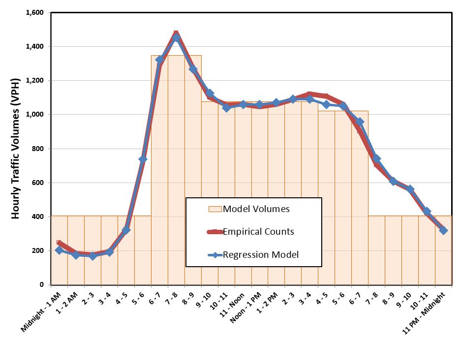
13 Result: A Tool That Can Es=mate & Graphically Display Hourly Volume Profiles Southbound
14 Result: A Tool That Can Es=mate & Graphically Display Hourly Volume Profiles 1,800 US - 99 E - - SE Mcloughlin Blvd N/O SE Park Ave, Year 2005 Northbound 1,600 1,400 1,200 1, Estimated Empirical 0


15 Step #3: Accoun=ng For Peak Spreading
16 The Hours of Conges=on Tool Helps Iden=fy and Assess Loca=ons for Opera=ons Improvements Lower Boones Ferry Road (northbound), 2035 Vehicles per Hour Hour
17 Project Team Review of HOC applica=on (1/2) } The results of the Hours of Conges)on sample corridor analysis reasonably match empirical data considering the accuracy of raw model data. } The network plots generated with the Hours of Conges)on results are easy to graphically present and explain. } The Hours of Conges)on applica)on is flexible enough to be applied to more focused corridor studies with post- processed volume data used as inputs.
18 Project Team Review of HOC applica=on (2/2) } The Hours of Conges)on data and network plots should be viewed cri)cally, as queue spillbacks and the corridor- wide impact on hours of conges)on is not captured with this link specific applica)on. This is similar to conduc)ng traffic signal analysis using isolated HCM methodology instead of coordinated corridor analysis in Synchro, or looking at tradi)onal model link v/c plots where conges)on does not impact upstream or downstream results. } Overall, the link- based applica)on is recognized as not being as robust as a trip- table based Dynamic Traffic Assignment (DTA) or ac)vity based modeling tool, but it is reasonable as an interim analysis tool applied to four- step travel model volumes over the next few years as Metro develops a more robust travel model. Even though the results of the Hours of Conges)on analysis does not adjust trip tables and/or reassign traffic, the resul)ng applica)on is quite useful at a macroscopic level as a priori)za)on and general policy tool, providing valuable informa)on on levels (hours) of conges)on not otherwise available.

19 Introducing Hours of Conges=on Into the Transporta=on Planning Process
20 Forecas=ng the Dura=on of Conges=on Improves Regional Transporta=on Discussions } Hours of Conges)on provides a dura)on measure for congested urban networks } Hours of Conges)on adds a new dimension to understanding key regional boilenecks } Hours of Conges)on helps iden)fy and assess loca)ons for opera)ons improvements } Hours of Conges)on provides a comparison to known na)onwide severely congested corridors


21 Hours of Conges)on provides a dura=on measure for congested urban networks Vehicles per Hour I-5 northbound ramp to Marquam Bridge, 2035 Hour Vehicles per Hour OR 43 (Macadam Avenue) northbound at Gaines Street, 2035 Hour

22 Hours of Conges)on adds a new dimension to understanding key regional boblenecks

23 Hours of Conges)on helps iden=fy and assess loca=ons for opera=ons improvements

24 Hours of Conges)on provides a comparison to known na=onwide severely congested corridors Location Corridor Year Hours of Congestion per Weekday Portland, OR Portland, OR I- 5 south of Columbia River I- 5 between I- 405 and I to to 14 New York, NY I Chicago, IL I- 90/I Los Angeles, CA US Source 2009 Data: INRIX National Traffic Scorecard 2009 Annual Report

25 HOC implemented as an embedded model script or post model run Excel- based applica=on


26 HOC methodology successfully applied to other models SACOG s SACMET Model

27 Ques=ons? Developing an Empirical Tool for Es=ma=ng Dura=on of Conges=on Ques=ons?
Travel Time Estimation Using Bluetooth
 Travel Time Estimation Using Bluetooth Ravindra Gudishala Chester Wilmot Aditya Mokkapatti Louisiana State University/Louisiana Transportation Research Center Objectives Estimate Travel Time in order to
ITS Canada Annual Conference and General Meeting. May 2013
 Evaluation of Travel Time Data Collection Technologies: An Innovative Approach for a Large- Scale Network ITS Canada Annual Conference and General Meeting May 2013 Study Steps Obtain the traffic data from
Bellevue s Traffic Adaptive Signals
 What we ll cover Bellevue s Traffic Adaptive Signals SCATS Phase 1 Implementation SCATS Operations Responsiveness New Features Some Initial Results 2011 Program and Beyond Final Thoughts ITE Quad Mtg April
SIMULATION AND ANALYSIS OF ARTERIAL TRAFFIC OPERATIONS ALONG THE US 61 CORRIDOR IN BURLINGTON, IOWA FINAL REPORT
 SIMULATION AND ANALYSIS OF ARTERIAL TRAFFIC OPERATIONS ALONG THE US 61 CORRIDOR IN BURLINGTON, IOWA FINAL REPORT Principal Investigator Tom Maze Principal Contributor Ali Kamyab Sponsored by the Engineering
Congestion Analysis with Historical Travel Time Data in Seoul
 Congestion Analysis with Historical Travel Time Data in Seoul Yohee Han Department of Traffic Engineering, University of Seoul, Seoul, South Korea Youngchan Kim Department of Traffic Engineering, University
ESTIMATING PARAMETERS FOR MODIFIED GREENSHIELD S MODEL AT FREEWAY SECTIONS FROM FIELD OBSERVATIONS
 0 ESTIMATING PARAMETERS FOR MODIFIED GREENSHIELD S MODEL AT FREEWAY SECTIONS FROM FIELD OBSERVATIONS Omor Sharif University of South Carolina Department of Civil and Environmental Engineering 00 Main Street
Speed Limit and Safety Nexus Studies for Automated Enforcement Locations in the District of Columbia Inside Southern part of 3rd Street Tunnel
 Speed Limit and Safety Nexus Studies for Automated Enforcement Locations in the District of Columbia Inside Southern part of 3rd Street Tunnel Study Area and Location District PSA Ward ANC Phase Description
Traffic Impact Study for the TAVA Homes Project at 1584 East Santa Clara Avenue in the City of Santa Ana
 Traffic Impact Study for the TAVA Homes Project at 1584 East Santa Clara Avenue in the City of Santa Ana March 2011 Prepared for: URS Corporation 2020 E. First Street, Suite #400 Santa Ana, CA 92705 Tel:
Calipatria Solar Farm TIA
 Calipatria Solar Farm TIA Prepared for: 7SM 8ME, LLC 71SM 8ME, LLC c/o 8minutenergy Renewables LLC Prepared by: Fehr & Peers March 25, 211 IE1-37 TABLE OF CONTENTS Executive Summary... i Project Trip Estimates...
Treating Potential Back- of-queue Safety. Developed By:
 Treating Potential Back- of-queue Safety Hazards Developed By: 1 Module Objectives Discuss the hazards associated with queuing caused by work zones Describe steps to quantify work zone impacts, determine
Final Report. Interstate-680 Bus-on-Shoulder Feasibility Assessment. prepared for
 Final Report Interstate-680 Bus-on-Shoulder Feasibility Assessment prepared for Metropolitan Transportation Commission & Contra Costa Transportation Authority prepared by HDR in association with Fehr &
APPENDIX E TRANSPORTATION
 APPENDIX E TRANSPORTATION 2011 PATRON SURVEYS VISSIM MODEL CALIBRATION AND VALIDATION Environmental and Planning Consultants 440 Park Avenue South 7th Floor New York, NY 10016 tel: 212 696-0670 fax:
Traffic Impact Study for the Girard Winery Project
 October 16, 2014 Ms. Heather McCollister 1512 D Street Napa, CA 94559 Traffic Impact Study for the Girard Winery Project Dear Ms. McCollister; Whitlock & Weinberger Transportation, Inc. (W-Trans) has completed
Study Area and Location District PSA Ward ANC Phase Description G Planned Connecticut Avenue Northbound at Military Road Northwest
 Speed Limit and Safety Nexus Studies for Automated Enforcement Locations in the District of Columbia Connecticut Avenue at Military Road NW Study Area and Location District PSA Ward ANC Phase Description
Creating transportation system intelligence using PeMS. Pravin Varaiya PeMS Development Group
 Creating transportation system intelligence using PeMS Pravin Varaiya PeMS Development Group Summary Conclusion System overview Routine reports: Congestion monitoring, LOS Finding bottlenecks Max flow
Using GPS Based Origin-Destination Data to Improve Traffic Studies. Michael R. Wahlstedt, PE, PTOE OTEC October 11, 2017
 Using GPS Based Origin-Destination Data to Improve Traffic Studies Michael R. Wahlstedt, PE, PTOE OTEC October 11, 2017 Overview Benefits of using O-D data for traffic analysis, particularly for operational
OR 217,I-5 Experience Portland, OR
 OR 217,I-5 Experience Portland, OR By: Abby Caringula Parsons Brinckerhoff July 8th, 2011 Presentation Outline Background VISUM Network Adjustment Model Origin-Destination(O-D) Demand Development ANM Export
Traffic Impact Analysis Shotwell Road Residential Clayton, NC
 Shotwell Road Residential Clayton, NC TABLE O CONTENTS 1. INTROUCTION...1 1.1. Site Location and Study Area...1 1.2. Proposed Land Use and Site Access...2 1.3. Adjacent Land Uses...2 1.4. Existing Roadways...2
Practical Use of ADUS for Real- Time Routing and Travel Time Prediction
 Practical Use of ADUS for Real- Time Routing and Travel Time Prediction Dr. Jaimyoung Kwon Statistics, Cal State East Bay, Hayward, CA, USA Dr. Karl Petty, Bill Morris, Eric Shieh Berkeley Transportation
Appendix D. Transportation Study
 Appendix D Transportation Study Draft KUNZLER TERRACE MINE PROJECT Transportation Study Prepared for May 29 County of Mendocino Draft KUNZLER TERRACE MINE PROJECT Transportation Study Prepared for May
APPENDIX D. Traffic Impact Analysis
 APPENDIX D Traffic Impact Analysis TRAFFIC IMPACT ANALYSIS CALEXICO SOLAR FARM I County of Imperial, California July 8, 2011 LLG Ref. 3-11-2034 Prepared by: Cara Leone Transportation Planner II Under the
Study Area and Location District PSA Ward ANC Phase Description D Proposed 1900 Block Foxhall Road Northwest Southbound
 Speed Limit and Safety Nexus Studies for Automated Enforcement Locations in the District of Columbia 19 Block Foxhall Road NW S/B Study Area and Location District PSA Ward ANC Phase Description 2 25 3
Opening the New Woodrow Wilson Memorial Bridge: Planning & Implementing a Major Traffic Switch
 Opening the New Memorial : Planning & Implementing a Major Traffic Switch Scott C. Crumley, P.E., P.T.O.E. Manager March 26, 2009 1 Agenda Background The Major Milestone: Opening the New to Traffic Challenges
Study Area and Location District PSA Ward ANC Phase Description B Planned Branch Avenue Northbound at Alabama Avenue Southeast
 Speed Limit and Safety Nexus Studies for Automated Enforcement Locations in the District of Columbia Branch Avenue at Alabama Avenue SE Study Area and Location District PSA Ward ANC Phase Description 6
Speed Limit and Safety Nexus Studies for Automated Enforcement Locations in the District of Columbia DC Miles South of Pennsylvania Avenue SE
 Speed Limit and Safety Nexus Studies for Automated Enforcement Locations in the District of Columbia DC 295.4 Miles South of Pennsylvania Avenue SE Study Area and Location District PSA Ward ANC Phase Description
Site 40. Recreational Center
 Speed Limit and Safety Nexus Studies for Automated Enforcement Locations in the District of Columbia Georgia Avenue S/B at Missouri Avenue NW Study Area and Location District PSA Ward ANC Phase Description
Speed Limit and Safety Nexus Studies for Automated Enforcement Locations in the District of Columbia East Capitol Street at Southern Avenue NE
 Speed Limit and Safety Nexus Studies for Automated Enforcement Locations in the District of Columbia East Capitol Street at Southern Avenue NE Study Area and Location District PSA Ward ANC Phase Description
ENHANCED PARKWAY STUDY: PHASE 3 REFINED MLT INTERSECTION ANALYSIS
 ENHANCED PARKWAY STUDY: PHASE 3 REFINED MLT INTERSECTION ANALYSIS Final Report Prepared for Maricopa County Department of Transportation Prepared by TABLE OF CONTENTS Page EXECUTIVE SUMMARY ES-1 STUDY
Managing DC Work Zones via a Citywide Transportation Management Plan. ITE Mid-Colonial District Annual Meeting May 20, 2014
 Managing DC Work Zones via a Citywide Transportation Management Plan ITE Mid-Colonial District Annual Meeting May 20, 2014 Presentation Outline The Team The Challenge The Approach Project Diagram Work
Managing DC Work Zones: DDOT s Citywide Transportation Management Plan
 Managing DC Work Zones: DDOT s Citywide Transportation Management Plan ARTBA National Work Zone Management Conference September 20, 2016 1 Outline Citywide Transportation Management Plan (TMP) Citywide
Study Area and Location District PSA Ward ANC Phase Description A Existing 1700 Block North Portal Drive Northwest Southwest-bound
 Speed Limit and Safety Nexus Studies for Automated Enforcement Locations in the District of Columbia 17 Block North Portal Drive NW Study Area and Location District PSA Ward ANC Phase Description 4 41
An Analysis of TDM Impacts on a Corridor Segment Research Findings
 An Analysis of TDM Impacts on a Corridor Segment Research Findings Phil Winters, CUTR TDM Program Director Liren Zhou, Graduate Research Assistant Sachin Rai, ITS Research Associate Nevine Georggi, TDM
An Integrated Model for Planning and Traffic Engineering
 Ninth TRB Planning Methods Applications Conference Baton Rouge, Louisiana, April 2003 An Integrated Model for Planning and Traffic Engineering Wolfgang Scherr, Innovative Transportation Concepts, Inc.,
Speed Limit and Safety Nexus Studies for Automated Enforcement Locations in the District of Columbia 1100 Block 4th Street NE
 Speed Limit and Safety Nexus Studies for Automated Enforcement Locations in the District of Columbia 11 Block 4th Street NE Study Area and Location District PSA Ward ANC Phase Description 1 14 6 6C Proposed
Data Hub and Data Bus for Improving the
 Data Hub and Data Bus for Improving the Effectiveness of Integrated Modeling Applications Xuesong Zhou (Arizona State University), xzhou74@asu.edu -Pronounced as Su-song Joe Acronym for extending traffic
CITY OF KIRKLAND TRAFFIC IMPACT ANALYSIS GUIDELINES
 CITY OF KIRKLAND TRAFFIC IMPACT ANALYSIS GUIDELINES SEPA TRANSPORTATION CONCURRENCY - ROAD IMPACT FEES Introduction Revised February 2004 These guidelines describe how to prepare a traffic study, or Traffic
Rutgers Interactive Lane Closure Application (RILCA) for Work Zone Planning User Manual. New Jersey Highway Authority. Garden State Parkway
 for Work Zone Planning User Manual. New Jersey Highway Authority. Garden State Parkway") Rutgers Interactive Lane Closure Application (RILCA) for Work Zone Planning User Manual Prepared for Garden State Parkway New Jersey Highway Authority April 2007 Developed by: Rutgers University Intelligent
Rutgers Interactive Lane Closure Application (RILCA) for Work Zone Planning User Manual Prepared for Garden State Parkway New Jersey Highway Authority April 2007 Developed by: Rutgers University Intelligent
Traffic Impact Analysis
 LA PALMA VILLAGE INITIAL STUDY CITY OF ANAHEIM Appendices Appendix I Traffic Impact Analysis September 2015 LA PALMA VILLAGE INITIAL STUDY CITY OF ANAHEIM Appendices This page intentionally left blank.
G. Computation of Travel Time Metrics DRAFT
 SHRP 2 Project L03 G. Computation of Travel Time Metrics Introduction The key principles for constructing reliability metrics for use in Project L03 is that the metrics must be based on the measurement
Addendum: Final Design Noise Analysis Study Noise Sensitive Area (NSA) 11 Post March 15, 2016 Open House Response to Comments
 11 Post March 15, 2016 Open House Response to Comments") Final Design Township of Lower Makefield, Bucks County, Pennsylvania Township of Ewing, Mercer County, New Jersey Addendum: Final Design Noise Analysis Study Noise Sensitive Area (NSA) 11 Post March 15,
Final Design Township of Lower Makefield, Bucks County, Pennsylvania Township of Ewing, Mercer County, New Jersey Addendum: Final Design Noise Analysis Study Noise Sensitive Area (NSA) 11 Post March 15,
Intelligent Transportation Traffic Data Management
 Intelligent Transportation Traffic Data Management Ugur Demiryurek Asscociate Director, IMSC Viterbi School of Engineering University of Southern California Los Angeles, CA 900890781 demiryur@usc.edu 1
Study Area and Location District PSA Ward ANC Phase Description A Proposed 6100 Block Georgia Avenue Northwest Southbound
 Speed Limit and Safety Nexus Studies for Automated Enforcement Locations in the District of Columbia 6100 Block Georgia Avenue NW Study Area and Location District PSA Ward ANC Phase Description 4 402 4
TRAFFIC IMPACT ANALYSIS. MIDWAY SOLAR FARM II County of Imperial, California January 11, 2011
 TRAFFIC IMPACT ANALYSIS MIDWAY SOLAR FARM II County of Imperial, California January 11, 2011 LLG Ref. 3-10-2013 Prepared by: Cara Leone Transportation Planner II Under the Supervision of: Chris Mendiara
Diomo Motuba Associate Research Fellow Transportation Seminar Series December 6, 2011
 Diomo Motuba Associate Research Fellow Transportation Seminar Series December 6, 2011 Outline Objectives Need For Study Travel Demand Models TDM OD/Travel Time Data Collection Methods Bluetooth Technology
Mobile Century data documentation
 Mobile Century data documentation December 16, 2009 Contents 1 USER AGREEMENT, TERMS OF USE 1 2 DESCRIPTION OF THE DATA 2 2.1 Inductive loop detector data................... 2 2.1.1 Inductive loop detector
Site 17 W3-160 KEY: District Department of Transportation 55 M Street, SE, Suite 400 Washington, DC 20003
 Speed Limit and Safety Nexus Studies for Automated Enforcement Locations in the District of Columbia Connecticut Avenue at Calvert Street NW Study Area and Location District PSA Ward ANC Phase Description
ROADWAY LIGHTING CURFEW
 STATE OF RHODE ISLAND AND PROVIDENCE PLANTATIONS Rhode Island Department of Transportation ROADWAY LIGHTING CURFEW IMPLEMENTATION PLAN March 25, 21 TABLE OF CONTENTS INTRUDUCTION/OVERVIEW... 1 1.1. ANTICIPATED
Study Area and Location District PSA Ward ANC Phase Description A Proposed I-395 Southwest after Exit 4, Eastbound
 Speed Limit and Safety Nexus Studies for Automated Enforcement Locations in the District of Columbia I-395 SW after Exit 4 E/B Study Area and Location District PSA Ward ANC Phase Description 1 71 8 8A
Part 2. VISUM Online for Salt Lake, Davis, and Utah Counties. Peter T. Martin, Aleksandar Stevanovic Ivana Vladisavljevic Dejan Jovanovic
 Design/Build vs. Traditional Construction User Delay Modeling: An Evaluation of the Cost Effectiveness of Innovative Construction Methods for New Construction Part 2 VISUM Online for Salt Lake, Davis,
Schedule-Driven Coordination for Real-Time Traffic Control
 Schedule-Driven Coordination for Real-Time Traffic Control Xiao-Feng Xie, Stephen F. Smith, Gregory J. Barlow The Robotics Institute Carnegie Mellon University International Conference on Automated Planning
An Assessment of Congestion in the Kansas City Region using the MARC Travel Demand Model
 An Assessment of Congestion in the Kansas City Region using the MARC Travel Demand Model The Congestion Management Process Federal Regulations state that all metropolitan planning organizations must carry
A New Framework for Development of Time Varying OD Matrices Based on Cellular Phone Data
 A New Framework for Development of Time Varying OD Matrices Based on Cellular Phone Data Corresponding Author: Jingtao Ma, Mygistics Inc. 9755 SW Barnes Rd Suite 550 Portland, OR 97225 Phone +01-503-575-2191,
Study Area and Location District PSA Ward ANC Phase Description C Existing 3500 Block Massachusetts Avenue Northwest Eastbound
 Speed Limit and Safety Nexus Studies for Automated Enforcement Locations in the District of Columbia 35 Block Massachusetts Avenue NW Study Area and Location District PSA Ward ANC Phase Description 2 24
M50 Demand Management Study
 Study Briefing paper to the Strategic Policy Committees (Transport) of : Dun Laoghaire Rathdown County Council, Dublin City Council Fingal County Council South Dublin Co Council 5 th June 2013 December
An Analysis of TDM Impacts on a Corridor Segment
 An Analysis of TDM Impacts on a Corridor Segment Phil Winters, CUTR TDM Program Director Liren Zhou, Graduate Research Assistant Sachin Rai, ITS Research Associate Nevine Georggi, TDM Research Associate
PeMS, Berkeley Highway Lab System, Data Fusion and Future Data Needs
 PeMS, Berkeley Highway Lab System, Data Fusion and Future Data Needs TRB Workshop on Data Fusion Beckman Conference Center Irvine, California April 15~17, 2009 Xiao-Yun Lu Research Engineer California
National Roundabout Conference 2005 DRAFT High-Capacity Roundabout Intersection Analysis: Going Around in Circles David Stanek, PE & Ronald T. Milam,
 High-Capacity Roundabout Intersection Analysis: Going Around in Circles David Stanek, PE & Ronald T. Milam, AICP TRB National Roundabout Conference May 24, 2005 Vail, CO Presentation Overview What is a
SHRP2 C10: Jacksonville
 SHRP2 C10: Jacksonville Partnership to Develop an Integrated Advanced Travel Demand Model and a Fine grained Timesensitive Network Presented by: Stephen Lawe Key Agency Partners: Florida Department of
Site 59 W5-147 KEY: District Department of Transportation 55 M Street, SE, Suite 400 Washington, DC 20003
 Speed Limit and Safety Nexus Studies for Automated Enforcement Locations in the District of Columbia 11 Block Bladensburg Road NE SW/B Study Area and Location District PSA Ward ANC Phase Description 5
The Practical Side of Cell Phones as Traffic Probes
 The Practical Side of Cell Phones as Traffic Probes The information contained in this document is considered proprietary, and may not be reproduced or redistributed without the consent of Delcan Inc. Cell
Validation of Simulation Models Using Vehicle Trajectories. TRB Annual Meeting January 11, 2015
 Validation of Simulation Models Using Vehicle Trajectories TRB Annual Meeting January 11, 2015 1 Overview Project Objectives and the Project Team State of Practice for Aggregate Calibration Trajectory
Looking Ahead. A Context for the Next Twenty Year Needs Assessment. July 2013
 Looking Ahead A Context for the Next Twenty Year Needs Assessment July 2013 A Larger Context for Twenty Year Needs Growing transit demand and complexity of travel paths and times Growing economy changing
Transit Development Plan/Transportation Demand. Chuck Steigerwald Director of Strategic Planning. Management Plan
 Transit Development Plan/Transportation Demand Chuck Steigerwald Director of Strategic Planning Management Plan OmniRide Strategic Plan Phase III TDP/TDMP Recommended service changes Ten-year plan Final
Ioannis Psarros Department of Civil Engineering and Intermodal Freight Transportation Institute, Memphis, TN
 Ioannis Psarros Department of Civil Engineering and Intermodal Freight Transportation Institute, Memphis, TN CIVL 7904/8904: Traffic Flow Theory (Spring 2014) April 5, 2014 Transportation Research Increased
PORTAL. A Case Study. Dr. Kristin Tufte Mark Wong September 23, Linux Plumbers Conference 2009
 PORTAL A Case Study Dr. Kristin Tufte (tufte@cecs.pdx.edu) Mark Wong (markwkm@postgresql.org) Linux Plumbers Conference 2009 September 23, 2009 Overview What is PORTAL? How PORTAL works Improving PORTAL
vision42
 vision42 www.vision42.org vision4 auto-free light rail 2 boulevard for 42nd Street Roxanne Warren, AIA, Chair George Haikalis, ASCE, Co-Chair Institute for Rational Urban Mobility,Inc. www.vision42.org
HILLTOP SENIOR LIVING CENTER Pollard Station Traffic Impact Analysis
 HILLTOP SENIOR LIVING CENTER Pollard Station Traffic Impact Analysis Prepared for Town of Truckee Prepared by TRANSPORTATION CONSULTANTS, INC. Pollard Station TRAFFIC IMPACT ANALYSIS Prepared for the Town
Los Angeles County Metropolitan Transportation Authority (Metro) Arterial Performance Measures Framework
 Arterial Performance Measures Framework") Los Angeles County Metropolitan Transportation Authority (Metro) Arterial Performance Measures Framework Anita Vandervalk-Ostrander Iteris, Inc. Santa Ana, California, USA Steven Gota, Deputy Executive
Los Angeles County Metropolitan Transportation Authority (Metro) Arterial Performance Measures Framework Anita Vandervalk-Ostrander Iteris, Inc. Santa Ana, California, USA Steven Gota, Deputy Executive
TRACY HILLS SPECIFIC PLAN RECIRCULATED DRAFT SUBSEQUENT ENVIRONMENTAL IMPACT REPORT VOLUME III OCTOBER 2015
 TRACY HILLS SPECIFIC PLAN RECIRCULATED DRAFT SUBSEQUENT ENVIRONMENTAL IMPACT REPORT VOLUME III OCTOBER 2015 APPENDIX H-6B CORRESPONDENCE DOCUMENTS LIVERMORE, DATED FALL 2014 Chau, Elizabeth From: Sent:
NJ Transit - Transit Signal Priority Intersection Evaluation Methodology A sketch planning approach to TSP prioritization
 NJ Transit - Transit Signal Priority Intersection Evaluation Methodology A sketch planning approach to TSP prioritization presented to NJDOT Research Showcase presented by Jennifer Strasser Cambridge Systematics,
APPLICATION OF ADVANCED ANALYSIS TOOLS FOR FREEWAY PERFORMANCE MEASUREMENT
 APPLICATION OF ADVANCED ANALYSIS TOOLS FOR FREEWAY PERFORMANCE MEASUREMENT Pantelis Kopelias Attikes Diadromes S.A., 41.9 Km of Attiki Odos, GR 19002 Peania, Athens, Greece Email:pkopelia@attikesdiadromes.gr
PROJECT TIMELINE. Next steps. Plan. Start of Service
 PROJECT TIMELINE 2018 2019 2020 2021 2022 2023 WE ARE HERE Plan Develop Build Develop design options for termini, station locations, and transit operations Conduct environmental research Assess funding
Defining and Measuring Urban Conges on
 Primer on Defining and Measuring Urban Conges on Introduc on Traffic congestion has become a major challenge in most urban areas. In recent years, the development of measures to mitigate traffic congestion
Crystal Springs Upland School Transportation Demand Management Plan. March 2016
 Crystal Springs Upland School Transportation Demand Management Plan March 06 CONTENTS Introduction... Transportation Demand Management (TDM) Program.... Background/Survey of Existing Student Commuting
Network Capacity, Traffic Instability, and Adaptive Driving: Findings from Simulated Network Experiments
 Network Capacity, Traffic Instability, and Adaptive Driving: Findings from Simulated Network Experiments Meead Saberi Transportation Center Northwestern University 600 Foster Street Evanston, IL, USA 60208-4055
Section 4.1: Time Series I. Jared S. Murray The University of Texas at Austin McCombs School of Business
 Section 4.1: Time Series I Jared S. Murray The University of Texas at Austin McCombs School of Business 1 Time Series Data and Dependence Time-series data are simply a collection of observations gathered
Regional Transit System (RTS) BRT Feasibility Study Project Kick-Off. Project Management Team Meeting May 22, 2008
 BRT Feasibility Study Project Kick-Off. Project Management Team Meeting May 22, 2008") Regional Transit System (RTS) BRT Feasibility Study Project Kick-Off Project Management Team Meeting May 22, 2008 Agenda Welcome and Introductions National Bus Rapid Transit Institute (NBRTI) Overview
Regional Transit System (RTS) BRT Feasibility Study Project Kick-Off Project Management Team Meeting May 22, 2008 Agenda Welcome and Introductions National Bus Rapid Transit Institute (NBRTI) Overview
CIE4801 Transportation and spatial modelling Beyond the 4-step model
 CIE4801 Transportation and spatial modelling Beyond the 4-step model Erik de Romph, Transport & Planning 31-08-18 Delft University of Technology Challenge the future Multi disciplinary 2 Contents Input
The Freeway Performance Measurement System (PeMS) (PeMS Version 3)
 (PeMS Version 3)") The Freeway Performance Measurement System (PeMS) (PeMS Version 3) Table of Contents Background Capabilities Your Feedback Appendix 1 Background What is PeMS? The Freeway Performance Measurement System
The Freeway Performance Measurement System (PeMS) (PeMS Version 3) Table of Contents Background Capabilities Your Feedback Appendix 1 Background What is PeMS? The Freeway Performance Measurement System
Study Area and Location District PSA Ward ANC Phase Description G Proposed 2900 Block Military Road Northwest Eastbound
 Speed Limit and Safety Nexus Studies for Automated Enforcement Locations in the District of Columbia 29 Block Military Road NW E/B Study Area and Location District PSA Ward ANC Phase Description 2 21 3
ESTIMATING REAL-TIME URBAN TRAFFIC STATES IN VISUM ONLINE
 ESTIMATING REAL-TIME URBAN TRAFFIC STATES IN VISUM ONLINE Dr.-Ing. Gerhard Ploss, PTV AG Munich, Germany *1) Dr.-Ing. Peter Vortisch, PTV AG Karlsruhe, Germany *2) 1 Introduction If a traffic management
195 Hegenberger Road Hotel: Traffic Circulation Analysis in Response to Comments on the Final EIR
 350 Frank H. Ogawa Plaza Suite 300 Oakland, CA 94612 510.839.5066 phone 510.839.5825 fax www.esassoc.com Technical Memorandum date November 12, 2014 to from subject Colleen Liang, Port Associate Environmental
Design Considerations for Real-time Arterial Performance Measurement Systems Using Transit Bus Probes
 Design Considerations for Real-time Arterial Performance Measurement Systems Using Transit Bus Probes Abraham Emmanuel & David Zavattero Chicago Department of Transportation Project Goals Estimate traffic
Analysis of Bluetooth and Wi-Fi Technology to Measure Wait Times of Personal Vehicles at Arizona-Mexico Ports of Entry
 Analysis of Bluetooth and Wi-Fi Technology to Measure Wait Times of Personal Vehicles at Arizona-Mexico Ports of Entry ITE 2016 Western District Annual Meeting July 2016 Presented by: Yung Koprowski, PE,
TxDOT TMS PERFORMANCE MEASURES ITS TEXAS Texas Department of Transportation
 TxDOT TMS PERFORMANCE MEASURES ITS TEXAS 2017 Texas Department of Transportation Traffic Management Systems November 2017 TRF-TM Update 1 2 Implementation of TMS Performance Metrics TMS Performance Metrics
ATR-TDA2, SC-TDA2: User Manual
 Minnesota Department of Transportation Office of Transportation Data Forecast and Analysis ATR-TDA2, SC-TDA2: User Manual Mar 25, 2014, Original Publication Dec, 2017, revised June, 2018, revised By Dr.
THE SOUTHERN GATEWAY MANAGED LANES PROJECT. Public Meetings Summer 2015 June 23, June 25, July 7, July 9
 THE SOUTHERN GATEWAY MANAGED LANES PROJECT Public Meetings Summer 2015 June 23, June 25, July 7, July 9 History & Background Began in 2001 as a Major Investment Study (MIS), Schematic, and Environmental
Network Fundamental Diagrams and their Dependence on Network Topology
 Network Fundamental Diagrams and their Dependence on Network Topology Victor L. Knoop 1 David de Jong 1 and Serge P. Hoogendoorn 1 Abstract Recent studies have shown that aggregated over a whole network
THE SOUTHERN GATEWAY MANAGED LANES PROJECT. Public Meetings Summer 2015 June 23, June 25, July 7, July 9
 THE SOUTHERN GATEWAY MANAGED LANES PROJECT Public Meetings Summer 2015 June 23, June 25, July 7, July 9 History & Background Began in 2001 as a Major Investment Study (MIS), Schematic, and Environmental
Metrobus 30s Line Enhancements
 Customer Service, Operations and Safety Committee Action Item III-C February 14, 2008 Metrobus 30s Line Enhancements Washington Metropolitan Area Transportation Authority Board Action/Information Summary
Understanding the Potential for Video Analytics to Support Traffic Management Functions
 Understanding the Potential for Video Analytics to Support Traffic Management Functions Project Summary Slides November 2014 ENTERPRISE Program Program Goals Facilitate rapid progress in the development
SMARTATL. A Smart City Overview and Roadmap. Evanta CIO Executive Summit 1
 SMARTATL A Smart City Overview and Roadmap Evanta CIO Executive Summit 1 Southeast USA Overview Evanta CIO Executive Summit 2 Metro Atlanta Overview Evanta CIO Executive Summit 3 Permits, New Units under
RHODES and Next Generation RHODES
 RHODES and Next Generation RHODES Pitu Mirchandani ATLAS Research Laboratory Arizona State University Is adaptive right for you? Panel ITE Meeting, Phoenix March 9, 2011 Acknowledgements: David Lucas,
Concept Definition Report Adaptive Urban Signal Control Integration (AUSCI) Project. Executive Summary -- August 1995
 Project. Executive Summary -- August 1995") Executive Summary -- August 1995 This summary highlights the work performed as part of the AUSCI Concept Definition Report. Additional supporting and background material is presented in a separate document
Executive Summary -- August 1995 This summary highlights the work performed as part of the AUSCI Concept Definition Report. Additional supporting and background material is presented in a separate document
The Next Generation of Transit Signal Priority: Cloud Computing and the TSP-as-a-Service Model
 The Next Generation of Transit Signal Priority: Cloud Computing and the TSP-as-a-Service Model September 20, 2017 TSP Conceptual Overview Extend green signal time at beginning or end of signal phase Approach
Utilization of TSMO Practices in Highway Construction Work Zones: A Case Study
 Utilization of TSMO Practices in Highway Construction Work Zones: A Case Study James Webb, P.E., Iowa Department of Transportation Liz Finarty, P.E., Iowa Department of Transportation James Armstrong,
Applying Analysis Tools in Planning for Operations
 Applying Analysis Tools in Planning for Operations Case Study #2 Incorporating Highway Capacity Manual Procedures into Long-Range Transportation Planning Notice This document is disseminated under the
Arterial data quality and traffic estimation
 Arterial data quality and traffic estimation Qijian Gan Postdoctoral Researcher PATH University of California, Berkeley qgan@berkeley.edu 10th SF Bay Area ITE Annual Workshop May 2nd, 2018 Outline Introduction
Data Driven Analysis in Transportation Systems
 Data Driven Analysis in Transportation Systems http://imsc.usc.edu/ Ugur Demiryurek, Ph.D. Associate Director, Integrated Media Systems Center (IMSC) Viterbi School of Engineering University of Southern
Title: Increasing the stability and robustness of simulation-based network assignment models for largescale
 Title: Increasing the stability and robustness of simulation-based network assignment models for largescale applications Author: Michael Mahut, INRO Consultants Inc. Larger-scale dynamic network models