Leica Pegasus: Backpack
|
|
|
- Anthony Willis
- 6 years ago
- Views:
Transcription


1 Leica Pegasus: Backpack Fast Acquisition Accurate data Indoor/Outdoor projects Pegasus:Backpack Simple workflow Everything, Everywhere 1


2 Leica Pegasus: Backpack Award Winning System Remarks Multiple Award winning system Winner Microsoft Indoor Navigation History Channel presence BBC Channel presence National Geographic presence 2


3 Leica Pegasus: Backpack Absolute Position: GNSS, INS & SLAM GNSS Navigation INS Navigation SLAM Navigation SLAM Outdoor & Limited Indoor Position Agnostic Simultaneous Localization And Mapping A method of measuring the environment and determining a location in that environment at the same time SLAM allows us to measure an arbitrary environment - No spatial context Mobile Mapping aims to precisely measure the environment - Technology limits where we can go Combining these techniques allows us to map arbitrary environments - No limits on location - Data has full spatial context


4 Leica Pegasus: Backpack System Overview External Synch Anschlus Ports for additional Sensors Carbon Unibody 12KG Global GNSS/GPS Triple Band, All Constellation, Novatel Propak 6 Dual Velodyne VLP-16 Scanner 600,000 pts/sec, Dual 360 x 30 Capturing Light Sensor Automatic Brightness Adjustment 5 x 4MP Camera 5.5 x 5.5 microns, 360 x 200 Panoramic Image Internal Industrial PC Multicore, Low Voltage, 1TB Internal Storage Remote Tablet Control Device Wireless, Touch Screen IMU 125HZ High-End Inertial Measurement Unit Battery operated Hot Swap Batteries, up to 4h Operational Time 4


5 Leica Pegasus: Backpack Additional Sensors Camera Ground Penetration Radar Thermal Camera External Sync Port Noise Sensor Pollution Sensor 5


6 Leica Pegasus: Backpack Flash Light Module as additional application extender Remarks Super light carbon fibre frame ~1kg Leverages expension port without modifying the hardware Opens new applications areas in complete darkness environment Unique selling point on the market any competitor 6


7 Leica Pegasus: Backpack 2 Different Configurations: Full and Outdoor FULL GNSS + INS + SLAM OUTDOOR GNSS + INS 7


8 8 Leica Pegasus: Backpack Outdoor Configuration GNSS+INS


9 9 Leica Pegasus: Backpack Full Configuration GPS+INS+SLAM

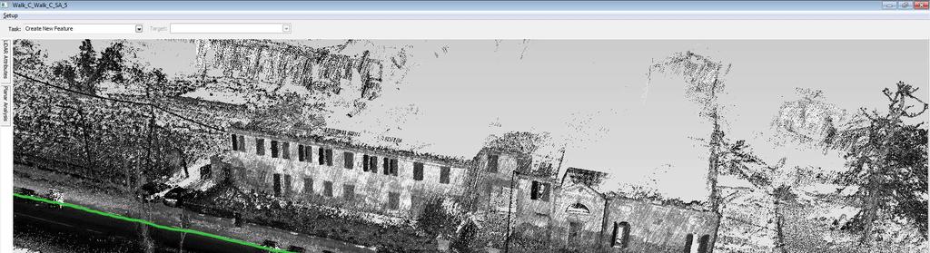
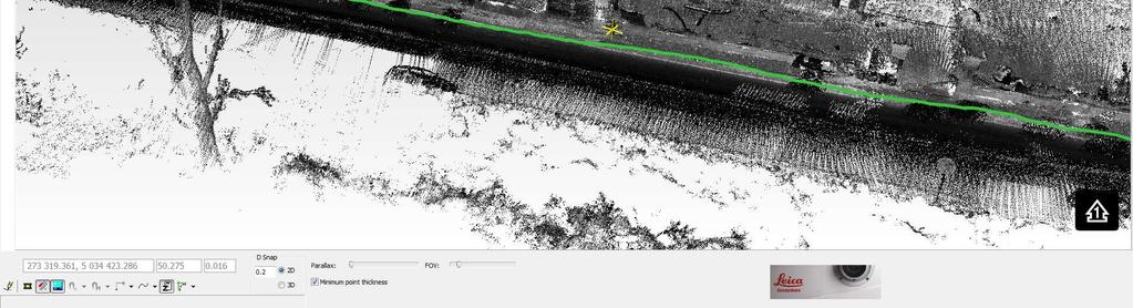
10 Leica Pegasus: Backpack System Overview Key Points Lidar & Imagery data collection Position agnostic indoor and outdoor positioning Additional sensors available Flash module for dark environments Lidar & Photogrammetry extraction tools Change detector for before-after comparison Integrated AutoCAD and ArcGIS Workflow 10


11 11 Software Workflow IE, Auto P, MapFactory
12 12 Leica Pegasus: Backpack Design Features


13 Leica Pegasus: Backpack Accuracy Concept Topography X,Y,Z Topology Database completeness Information obsolescence 13

14 Leica Pegasus: Backpack Application Areas Professional Documentation - BIM Vehicle Restricted Areas Disaster Recovery Pegasus:Backpack Asset Extraction and Management Safety / Security DTM & Surface Analysis 14


15 Moving into BIM through construction documentation Authoritative Documentation Tool 1D 2D 3D 4D / 5D 6D Concept Design Analysis & Construction Operation & Maintenance Documentation Milestones Monitoring Lifecycle BIM Documentation: Lean Scheduling - Maintenance - Last Planner - BIM digital file exchange - Just In Time Equipment - LEED tracking Deliveries - Sustainable element tracking - Detailed Simulation Installation 15 Visual Validation for Payment Approval


16 Vehicle Restricted Areas Mapping where no other vehicles can access


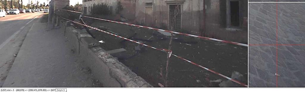
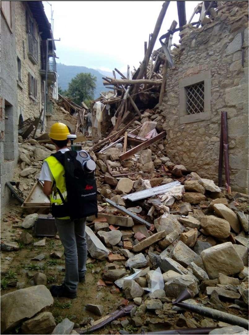
17 Disaster recovery Dolo, Italy Palladio Building UNESCO - Renaissance


18 Disaster recovery Change Detector Automatic Change Detection Change detection and multi-temporal series analysis 18

19 Virtual Training Realistic VR data for Health and Safety Induction Realistic VR data Fast refresh of data Safe and Secure No need to stop production 19


20 Indoor Projects Business Design Centre, London


21 Digital Terrain Models Golf Course, DTM and Analysis in 3DReshaper


22 Forestry Datasets Samples Forestry Applications Trees Monitoring Trunk Extraction Timber classification Plants Health Slope and Flood Analysis Firebreak inspection Wildfire Risk Study 22


23 Forestry Scandinavian Forest


24 Asset Extraction and Site Management Electrical Substation Applications Asset Extraction and Management Powerline Extraction and Analysis New Developments and Upgrades Health and Safety 24

25 Asset Extraction Access to Offroad Sites for Powerline Extraction Outdoor application Powerline Extraction and Analysis Access to Offroad Areas Advantage of Lightness and Ergonomy Speed Up the Workflow 25


26 Ski Slopes Maintenance Mobile Mapping + Machine Control BackPack Advantages DTM Generation Surface Analysis Snow Thickness Management Accurate Results 26


27 Forensics and Crash Investigations Crime Scenes and Car Accidents BackPack Advantages Fast and Accurate Acquisition Imagery & Point Cloud Indoor and Outdoor No registration or GCP needed Simple workflow 27
28 Leica Pegasus: Backpack Conclusions Capture Everything & Everywhere Fast and Accurate Data Acquisition and Post-Processing Point Cloud & Imagery Multiple applications NO Registration or GCP needed Safe and Secure Speed Up workflows and Increase Productivity Time/MONEY Saving 28

29 THANKS! Questions? Pegasus:Backpack 29
Leica Geosystems Regional Public Safety Conference. Joshua Rayburn Consolidated Forensic Laboratory, Washington DC Present Date:
 Leica Geosystems Regional Public Safety Conference Joshua Rayburn Consolidated Forensic Laboratory, Washington DC Present Date: 04.15.15 2 What is a Pegasus? Portable survey-grade mobile mapping solution
Comparative study on the differences between the mobile mapping backpack systems ROBIN- 3D Laser Mapping, and Pegasus- Leica Geosystems.
 3 th Bachelor Real Estate, Land Surveying Measuring Methods III Comparative study on the differences between the mobile mapping backpack systems ROBIN- 3D Laser Mapping, and Pegasus- Leica Geosystems.
ROAD-SCANNER COMPACT APPLICATION FIELDS MAIN FEATURES
 ROAD-SCANNER COMPACT Mobile Mapping System by GEXCEL & SITECO collaboration A smaller mobile system for asset management and cartography suited for ZOLLER & FRÖHLICH PROFILER 9012 laser scanner. 2 + 3
BIM & Digital Transformation Scotland Live 2018 Capturing 3D Reality at the push of a button
 BIM & Digital Transformation Scotland Live 2018 Capturing 3D Reality at the push of a button Gary Kelly Country Manager Scotland Leica Geosystems @LeicaScot Capturing 3D Reality at the push of a button
Jeffrey A. Schepers P.S. EIT Geospatial Services Holland Engineering Inc. 220 Hoover Blvd, Suite 2, Holland, MI Desk
 Jeffrey A. Schepers P.S. EIT Geospatial Services Holland Engineering Inc. 220 Hoover Blvd, Suite 2, Holland, MI 49423 616-594-5127 Desk 616-322-1724 Cell 616-392-5938 Office Mobile LiDAR - Laser Scanning
Hardware 3D Mapping Systems
 Hardware 3D Mapping Systems About Us GreenValley International GreenValley International provides 3D mapping solutions that include mobile & aerial LiDAR acquisition hardware, post-processing software
3D ponttechnológia használata napjainkban október. 10. Tatabány, Mérnöki továbbképzés Zeke Zsolt Mérnök üzletkötő
 3D ponttechnológia használata napjainkban 2018. október. 10. Tatabány, Mérnöki továbbképzés Zeke Zsolt Mérnök üzletkötő Leica BLK3D NEW based on photogrametry Leica HDS Termékportfólió BLK360 RTC360 P40/50
Overview of the Trimble TX5 Laser Scanner
 Overview of the Trimble TX5 Laser Scanner Trimble TX5 Revolutionary and versatile scanning solution Compact / Lightweight Efficient Economical Ease of Use Small and Compact Smallest and most compact 3D
Introducing. GeoSLAM. The experts in go anywhere 3D mobile mapping technology. The Company. The Technology. The Applications. Strategic Partnerships
 Introducing GeoSLAM The experts in go anywhere 3D mobile mapping technology The Company The Technology The Applications Strategic Partnerships The Company Multipurpose Presentation Template 2 About Us
Terrain Modeling and Mapping for Telecom Network Installation Using Scanning Technology. Maziana Muhamad
 Terrain Modeling and Mapping for Telecom Network Installation Using Scanning Technology Maziana Muhamad Summarising LiDAR (Airborne Laser Scanning) LiDAR is a reliable survey technique, capable of: acquiring
Trimble VISION Positions from Pictures
 Trimble VISION Positions from Pictures This session will cover What Is Trimble VISION? Trimble VISION Portfolio What Do you Need? How Does It Work & How Accurate Is It? Applications Resources Trimble VISION
2/9/2016. Session Agenda: Implementing new Geospatial Technologies for more efficient data capture
 Implementing new Geospatial Technologies for more efficient data capture Jay Haskamp Applied Geospatial Engineer Steve Richter VP Sales Session Agenda: Today s changing technologies and what lies ahead
InteLAS Family of Mobile LiDAR Systems
 InteLAS Family of Mobile LiDAR Systems September 2015 What we do ilinks Geosolutions LLC Hydrographic surveying and seabed modeling Topographic surveying and mobile mapping Systems engineering and integration
Rapid Building information modeling. Ivar Oveland 2013
 Rapid Building information modeling Ivar Oveland 2013 Case study How can I rapidly create a building information model? Today: Different methods are used today to establish a building information model
2/19/2018. Who are we? Who am I? What is Scanning? How does scanning work? How does scanning work? Scanning for Today s Surveyors
 2/19/2018 Who are we? Scanning for Today s Surveyors Survey, GIS, and Construction dealer Founded in 1988 Employee Owned Headquartered in Bismarck, ND States covered: ND, SD, MN, MT, WY, CO, UT, ID, WA,
Leica Geosystems UAS Airborne Sensors. MAPPS Summer Conference July 2014 Alistair Stuart
 Leica Geosystems UAS Airborne Sensors MAPPS Summer Conference July 2014 Alistair Stuart 1 Sensors for UAS! Promise of UAS is to expand aerial data acquisition capabilities for traditional and non-traditional
Reality Capture using: RPAS Technologies & Image Laser Scanners
 Reality Capture using: RPAS Technologies & Image Laser Scanners by Johan Erasmus (RPAS Technologies) & Barend Bornman (Image Laser Scanners) from Aciel Geomatics Laser Scanners High-Definition Surveying
Real world data collecting tools. Company Introduction. C2L equipment.co,.ltd
 Company Introduction C2L equipment.co,.ltd www.c2l-equipment.com Company Status Business Areas Company name C2L equipment.co,.ltd Address CEO Unit 603, Samwhan HIPEX B, Pangyo Station RD 230, Bundang,
Iwane Mobile Mapping System
 Iwane Mobile Mapping System Geo-Imaging Mobile Mapping Solution Iwane Mobile Mapping System (IMMS) is high-efficient, easyto-use, end-to-end solution that provides tremendous flexibility in collecting,
Trimble Mobile Mapping Portfolio
 Jörg Amend Sales Account Manager SEPTEMBER 20 2017 Trimble Mobile Mapping Portfolio Current challenges and trends Multible Sensors connecting to one Echosystem Trimble RealWorks Trimble Edgewise TBC Pathfinder
HANDHELD MOBILE MAPPING / 3D LASER MAPPING SOLUTIONS. ZEB Family Brochure. geoslam.com
 HANDHELD MOBILE MAPPING / 3D LASER MAPPING SOLUTIONS ZEB Family Brochure geoslam.com NEW Long range, greater intensity, UAV ready HANDHELD BACKPACK UAV Effortless Data Capture Your tool to capture, view
The Use of UAV s for Gathering Spatial Information. James Van Rens CEO MAPPS Winter Conference January, 2015
 The Use of UAV s for Gathering Spatial Information James Van Rens CEO MAPPS Winter Conference January, 2015 1 UAV Technological Timeline 1980 s RPV (Remotely Piloted Vehicle) Operator on ground, almost
Leica BLK360 Questions & Answers. Vers
 Questions & Answers Vers. 11.01.2017 What is it? 2 What is it? 3 What is it? Calibrated full spherical image, LED flash support 4 What is it? 5 A new, simple way to capture reality Speed On-the-fly image
Bringing Singapore to life in 3D
 Bringing Singapore to life in 3D Dr Victor Khoo, Deputy Director Singapore Land Authority Bringing Singapore to life in 3D ESRI Singapore UC 2016 Dr. Victor Khoo Singapore Land Authority SLA 2016 RESTRICTED
A New Direction in GIS Data Collection or Why Are You Still in the Field?
 GeoAutomation The Mobile Mapping System Survey-Enabled Imagery A New Direction in GIS Data Collection or Why Are You Still in the Field? Presentation to: URISA BC GIS Technology Showcase January 19, 2011
ENY-C2005 Geoinformation in Environmental Modeling Lecture 4b: Laser scanning
 1 ENY-C2005 Geoinformation in Environmental Modeling Lecture 4b: Laser scanning Petri Rönnholm Aalto University 2 Learning objectives To recognize applications of laser scanning To understand principles
Geospatial Engineering Problems & Solutions Associated With NDP Roads, Tunnelling & Civil Engineering Projects Use of HDS Leica Laser Scanners
 Geospatial Engineering Problems & Solutions Associated With NDP Roads, Tunnelling & Civil Engineering Projects Use of HDS Leica Laser Scanners Laser Scanning Laser Scanning is a method of collecting large
REMOTE SENSING LiDAR & PHOTOGRAMMETRY 19 May 2017
 REMOTE SENSING LiDAR & PHOTOGRAMMETRY 19 May 2017 SERVICES Visual Inspections Digital Terrain Models Aerial Imagery Volume Computations Thermal Inspections Photo maps Aerial Video Training & Consultancy
High resolution survey and orthophoto project of the Dosso-Gaya region in the Republic of Niger. by Tim Leary, Woolpert Inc.
 High resolution survey and orthophoto project of the Dosso-Gaya region in the Republic of Niger by Tim Leary, Woolpert Inc. Geospatial Solutions Photogrammetry & Remote Sensing LiDAR Professional Surveying
RealWorld RealCity RealTerrain Airborne Reality Capture The Integral World of Leica Airborne Solutions
 RealWorld RealCity RealTerrain Airborne Reality Capture The Integral World of Leica Airborne Solutions Photogrammetric Week, September 11, 2017 Dr. Hartmut Rosengarten, Director Airborne Solutions EMEA,
GeoSLAM Overview. The experts in go-anywhere 3D mobile mapping technology
 GeoSLAM Overview The experts in go-anywhere 3D mobile mapping technology 1 About GeoSLAM The experts in go-anywhere 3D mobile mapping technology 2 Who We Are GeoSLAM is a global market leader in go-anywhere
A Whole New World of Mapping and Sensing: Uses from Asset to Management to In Vehicle Sensing for Collision Avoidance
 A Whole New World of Mapping and Sensing: Uses from Asset to Management to In Vehicle Sensing for Collision Avoidance Charles Toth, Dorota A Grejner-Brzezinska, Carla Bailo and Joanna Pinkerton Satellite
Leica ALS70. Airborne Laser Scanners Performance for diverse Applications
 Leica ALS70 Airborne Laser Scanners Performance for diverse Applications Three Models, One Result. Highest Productivity in all Applications. Imagine an affordable 500 khz pulse rate city-mapping LIDAR
STARTING WITH DRONES. Data Collection and Remote Sensing with UAVs, etc. Dr. Bill Hazelton LS
 STARTING WITH DRONES Data Collection and Remote Sensing with UAVs, etc. Dr. Bill Hazelton LS What this Talk is About UAV-based data acquisition: What you need to get involved Processes in getting spatial
Simplicity is the new black: The BLK360 story
 Simplicity is the new black: The BLK360 story Vanda KADLECIKOVA Leica Geosystems Heerbrugg, Switzerland E-mail: vanda.kadlecikova@leica-geosystems.com Abstract Meet the game changer. The new Leica BLK360
Freestyle 3D. Features and applications. Dr. Daniel Döring Team Lead Product Development Freestyle 1
 Freestyle 3D Features and applications Dr. Daniel Döring Team Lead Product Development Freestyle 1 3D scanning Building works: How to record data? How to check what has been built? How to fit in new parts?
CE 59700: LASER SCANNING
 Digital Photogrammetry Research Group Lyles School of Civil Engineering Purdue University, USA Webpage: http://purdue.edu/ce/ Email: ahabib@purdue.edu CE 59700: LASER SCANNING 1 Contact Information Instructor:
Multisensoral UAV-Based Reference Measurements for Forestry Applications
 Multisensoral UAV-Based Reference Measurements for Forestry Applications Research Manager D.Sc. Anttoni Jaakkola Centre of Excellence in Laser Scanning Research 2 Outline UAV applications Reference level
THE RANGER-UAV FEATURES
 THE RANGER-UAV The Ranger Series Ranger-UAV is designed for the most demanding mapping applications, no compromises made. With a 9 meter laser range, this system produces photorealistic 3D point clouds
2-4 April 2019 Taets Art and Event Park, Amsterdam CLICK TO KNOW MORE
 Co-Host Host 2-4 April 2019 Taets Art and Event Park, Amsterdam CLICK TO KNOW MORE Presentation Outline review modern survey methodologies available to support railway requirements measuring everything
Case Study for Long- Range Beyond Visual Line of Sight Project. March 15, 2018 RMEL Transmission and Planning Conference
 Case Study for Long- Range Beyond Visual Line of Sight Project March 15, 2018 RMEL Transmission and Planning Conference 2014 HDR Architecture, 2016 2014 HDR, Inc., all all rights reserved. Helicopters
GeoSmart Asia Locate 18
 MOBILE MAPPING GeoSmart Asia Locate 18 ESP Associates, P.A. ESP Associates, P.A. ABOUT ESP Founded in 1986 (28 Years of Experience with DOT s) ESP has 14 offices throughout the US 37 States, Canada, and
Leica Public Safety Solutions Versatile. Durable. Admissible
 Leica Public Safety Solutions Versatile. Durable. Admissible Public Safety Solutions 3D Laser Scanners Software Training and Consulting Services Leica ScanStation PS Series Professional Grade 3D Laser
Reality Modeling Drone Capture Guide
 Reality Modeling Drone Capture Guide Discover the best practices for photo acquisition-leveraging drones to create 3D reality models with ContextCapture, Bentley s reality modeling software. Learn the
Backpack-based inertial navigation and LiDAR mapping in forest environments
 Backpack-based inertial navigation and LiDAR mapping in forest environments Mattias Tjernqvist June 2017 Introduction 3D model our environment Light Detection And Ranging (LiDAR) - Light - Laser scanner
Mobile Mapping and Navigation. Brad Kohlmeyer NAVTEQ Research
 Mobile Mapping and Navigation Brad Kohlmeyer NAVTEQ Research Mobile Mapping & Navigation Markets Automotive Enterprise Internet & Wireless Mobile Devices 2 Local Knowledge & Presence Used to Create Most
Trimble GeoSpatial Products
 Expanding Solutions for Photogrammetric and Remote Sensing Professionals 55 th Photogrammetric Week in Stuttgart September 7 th 2015 Tobias Heuchel, Trimble Stuttgart, Germany Trimble GeoSpatial Products
ALS40 Airborne Laser Scanner
 ALS40 Airborne Laser Scanner Airborne LIDAR for Professionals High Performance Laser Scanning Direct Measurement of Ground Surface from the Air The ALS40 Airborne Laser Scanner measures the topography
AN INTEGRATED SENSOR ORIENTATION SYSTEM FOR AIRBORNE PHOTOGRAMMETRIC APPLICATIONS
 AN INTEGRATED SENSOR ORIENTATION SYSTEM FOR AIRBORNE PHOTOGRAMMETRIC APPLICATIONS M. J. Smith a, *, N. Kokkas a, D.W.G. Park b a Faculty of Engineering, The University of Nottingham, Innovation Park, Triumph
Data, Data, Everywhere. We are now in the Big Data Era.
 Data, Data, Everywhere. We are now in the Big Data Era. CONTENTS Background Big Data What is Generating our Big Data Physical Management of Big Data Optimisation in Data Processing Techniques for Handling
LiForest Software White paper. TRGS, 3070 M St., Merced, 93610, Phone , LiForest
 0 LiForest LiForest is a platform to manipulate large LiDAR point clouds and extract useful information specifically for forest applications. It integrates a variety of advanced LiDAR processing algorithms
CLASSIFICATION OF NONPHOTOGRAPHIC REMOTE SENSORS
 CLASSIFICATION OF NONPHOTOGRAPHIC REMOTE SENSORS PASSIVE ACTIVE DIGITAL CAMERA THERMAL (e.g. TIMS) VIDEO CAMERA MULTI- SPECTRAL SCANNERS VISIBLE & NIR MICROWAVE HYPERSPECTRAL (e.g. AVIRIS) SLAR Real Aperture
An Introduction to Lidar & Forestry May 2013
 An Introduction to Lidar & Forestry May 2013 Introduction to Lidar & Forestry Lidar technology Derivatives from point clouds Applied to forestry Publish & Share Futures Lidar Light Detection And Ranging
Trends in Digital Aerial Acquisition Systems
 Trends in Digital Aerial Acquisition Systems Ernest Yap Regional Sales Manager, Airborne-Americas eyap@applanix.com 1 Medium Format Digital Cameras Medium Format Digital Cameras Where does the Medium
ROAD SURFACE STRUCTURE MONITORING AND ANALYSIS USING HIGH PRECISION GPS MOBILE MEASUREMENT SYSTEMS (MMS)
") ROAD SURFACE STRUCTURE MONITORING AND ANALYSIS USING HIGH PRECISION GPS MOBILE MEASUREMENT SYSTEMS (MMS) Bonifacio R. Prieto PASCO Philippines Corporation, Pasig City, 1605, Philippines Email: bonifacio_prieto@pascoph.com
ROAD SURFACE STRUCTURE MONITORING AND ANALYSIS USING HIGH PRECISION GPS MOBILE MEASUREMENT SYSTEMS (MMS) Bonifacio R. Prieto PASCO Philippines Corporation, Pasig City, 1605, Philippines Email: bonifacio_prieto@pascoph.com
GNSS/INS for High Accuracy Mobile Mapping. Olaf Gross 11 th Terrasolid European User Event Kittilä, Finland
 GNSS/INS for High Accuracy Mobile Mapping Olaf Gross 11 th Terrasolid European User Event 15.02.2012 Kittilä, Finland IGI mbh Founded 1978 25 staff about half in R&D More than 380 customers in 60 different
LIDAR and Terrain Models: In 3D!
 LIDAR and Terrain Models: In 3D! Stuart.green@teagasc.ie http://www.esri.com/library/whitepapers/pdfs/lidar-analysis-forestry.pdf http://www.csc.noaa.gov/digitalcoast/_/pdf/refinement_of_topographic_lidar_to_create_a_bare_e
UAVs & IMAGES ACCESSORIES ABOUT GEXCEL
 LIDAR SOFTWARE UAVs & IMAGES MONITORING MOBILE MAPPING ACCESSORIES OTHER ABOUT GEXCEL BUSINESS TEAM LOCATIONS Gexcel offices are located in Italy in two Innovation Centers SALES NETWORK Gexcel s worldwide
N.J.P.L.S. An Introduction to LiDAR Concepts and Applications
 N.J.P.L.S. An Introduction to LiDAR Concepts and Applications Presentation Outline LIDAR Data Capture Advantages of Lidar Technology Basics Intensity and Multiple Returns Lidar Accuracy Airborne Laser
Airborne and Mobile LiDAR for Transport Corridor Survey Dr. Bharat Lohani Director, Geokno India Pvt. Ltd. & Professor, Geoinformatics IIT Kanpur
 www.geokno.com Airborne and Mobile LiDAR for Transport Corridor Survey Dr. Bharat Lohani Director, Geokno India Pvt. Ltd. & Professor, Geoinformatics IIT Kanpur Geokno has executed and is executing multiple
Automated Feature Extraction from Aerial Imagery for Forestry Projects
 Automated Feature Extraction from Aerial Imagery for Forestry Projects Esri UC 2015 UC706 Tuesday July 21 Bart Matthews - Photogrammetrist US Forest Service Southwestern Region Brad Weigle Sr. Program
Laser scanners with echo digitization for full waveform analysis
 Laser scanners with echo digitization for full waveform analysis Peter Rieger, Andreas Ullrich, Rainer Reichert RIEGL Laser Measurement Systems GmbH DI Peter Rieger Project Management RIEGL LMS GmbH A-3580
Leica ALS80 Airborne Laser Scanners Performance for every Application
 Leica ALS80 Airborne Laser Scanners Performance for every Application Three Models, One Result. Highest Productivity in all Applications. Imagine an affordable city-mapping LIDAR system with an industry-leading
Chapter 1: Overview. Photogrammetry: Introduction & Applications Photogrammetric tools:
 Chapter 1: Overview Photogrammetry: Introduction & Applications Photogrammetric tools: Rotation matrices Photogrammetric point positioning Photogrammetric bundle adjustment This chapter will cover the
Shaping the World with Leica Zeno GIS Asset Collection & Management
 Shaping the World with Leica Zeno GIS Asset Collection & Management Edward Toh GIS Segment Manager, APAC Agenda Power of Geography Location bring values Case Studies Integration of Surveyors into GIS Leica
Sensor Fusion: Potential, Challenges and Applications. Presented by KVH Industries and Geodetics, Inc. December 2016
 Sensor Fusion: Potential, Challenges and Applications Presented by KVH Industries and Geodetics, Inc. December 2016 1 KVH Industries Overview Innovative technology company 600 employees worldwide Focused
Lidar Sensors, Today & Tomorrow. Christian Sevcik RIEGL Laser Measurement Systems
 Lidar Sensors, Today & Tomorrow Christian Sevcik RIEGL Laser Measurement Systems o o o o Online Waveform technology Stand alone operation no field computer required Remote control through wireless network
Trimble Geospatial Division Integrated Solutions for Geomatics professions. Volker Zirn Regional Sales Representative
 Trimble Geospatial Division Integrated Solutions for Geomatics professions Volker Zirn Regional Sales Representative 1 Agenda Trimble GeoSpatial Division Airborne System Solutions Trimble Inpho Software
A New Protocol of CSI For The Royal Canadian Mounted Police
 A New Protocol of CSI For The Royal Canadian Mounted Police I. Introduction The Royal Canadian Mounted Police started using Unmanned Aerial Vehicles to help them with their work on collision and crime
Precision Roadway Feature Mapping Jay A. Farrell, University of California-Riverside James A. Arnold, Department of Transportation
 Precision Roadway Feature Mapping Jay A. Farrell, University of California-Riverside James A. Arnold, Department of Transportation February 26, 2013 ESRA Fed. GIS Outline: Big picture: Positioning and
Trimble Indoor Mobile Mapping Solution
 Kevin Perkins Applanix Corp. NATIONAL SURVEYING, MAPPING & GEOSPATIAL CONFERENCE - MARCH 13-17, 2017 Trimble Indoor Mobile Mapping Solution Why Indoor Mapping? The need: As-built maps/models of indoor
KRISTAPS KLAVA - HEAD OF LASER SCANNING DEPARTMENT AT MERKO 3D LASER SCANNING POSSIBILITIES IN REAL ESTATE
 KRISTAPS KLAVA - HEAD OF LASER SCANNING DEPARTMENT AT MERKO 3D LASER SCANNING POSSIBILITIES IN REAL ESTATE Overview 1. What is laser scanning; 2. Technology; 3. End results of laser scanning; 4. Applications;
High Resolution Laserscanning, not only for 3D-City Models
 Lohr 133 High Resolution Laserscanning, not only for 3D-City Models UWE LOHR, Ravensburg ABSTRACT The TopoSys laserscanner system is designed to produce digital elevation models (DEMs) of the environment
Applications of Mobile LiDAR and UAV Sourced Photogrammetry
 Applications of Mobile LiDAR and UAV Sourced Photogrammetry Thomas J. Pingel and Earle W. Isibue Northern Illinois University 2017 Illinois GIS Association (ILGISA) Annual Meeting October 2-4, 2017 tpingel.org
NEW APPROACH FOR SAFE, FAST AND ACCURATE SURVEY OF DEEP MINE SHAFTS
 NEW APPROACH FOR SAFE, FAST AND ACCURATE SURVEY OF DEEP MINE SHAFTS by Norbert Benecke & Peter Cain DMT GmbH &Co. KG, Germany / DMT Geosciences, Canada Kinemattic Shaft Survey 2013 Page 1 Who is DMT? is
Chapters 1 9: Overview
 Chapters 1 9: Overview Chapter 1: Introduction Chapters 2 4: Data acquisition Chapters 5 9: Data manipulation Chapter 5: Vertical imagery Chapter 6: Image coordinate measurements and refinements Chapters
GeoSLAM Overview. The global leader in go anywhere 3D mobile mapping technology. 1
 GeoSLAM Overview The global leader in go anywhere 3D mobile mapping technology. 1 About GeoSLAM The global leader in go anywhere 3D mobile mapping technology. 2 Who We Are GeoSLAM is a global market leader
UNBEATABLE ACCURACY IN MOBILE 3D LASERSCANNING
 UNBEATABLE ACCURACY IN MOBILE 3D LASERSCANNING COMPANY PROFILE THINK 3D etablished in 2007 Marketleader 3D laserscanning in Belgium Markets: oil&gas, pharmaceutical, food industry, infrastructure, Services:
The Most Comprehensive Solution for Indoor Mapping Applications
 The Most Comprehensive Solution for Indoor Mapping Applications TRIMBLE INDOOR MOBILE MAPPING SOLUTION TRIMBLE INDOOR MOBILE MAPPING SOLUTION (TIMMS): HIGH EFFICIENCY, MAXIMUM FLEXIBILITY, ALL-IN-ONE PACKAGE
Trimble UAS Portfolio Update. August 25 th 2015
 Trimble UAS Portfolio Update August 25 th 2015 Trimble UAS Portfolio Updates Trimble UX5 Setting the Standard in Mapping Trimble UX5 HP High Precision Surveying and Mapping Solution Trimble ZX5 Flexible
Geosmart Asia Automated Scan Data Registration for Improving TLS Data Acquisition Efficiency. Thomas Gaisecker. April, 2018
 Geosmart Asia 2018 Automated Scan Data Registration for Improving TLS Data Acquisition Efficiency Thomas Gaisecker April, 2018 Content RIEGL VZ-400i/VZ-2000i key facts Hardware/Firmeware Architecture Onboard
IP-S2 HD. High Definition 3D Mobile Mapping System
 IP-S2 HD High Definition 3D Mobile Mapping System Integrated, turnkey solution Georeferenced, Time-Stamped, Point Clouds and Imagery High Density, Long Range LiDAR sensor for ultimate in visual detail
Cesium Co. Ltd., Company Profile. Certification. Laboratory. Metrology Standards. When Performance Matters. Testing Quality
 Cesium Co. Ltd., Quality, Reliability & Excellence Company Profile Certification When Performance Matters Pleasanton, CA USA London UK Al Khobar - KSA Laboratory Metrology Standards Accreditation Process
E3De. E3De Discover the Next Dimension of Your Data.
 International Support Exelis Visual Information Solutions is a global company with direct offices in North America, Europe, and Asia. Combined with our extensive, worldwide distributor network, we can
SPAR, ELMF 2013, Amsterdam. Laser Scanning on the UK Highways Agency Network. Hamish Grierson Blom Uk
 SPAR, ELMF 2013, Amsterdam Laser Scanning on the UK Highways Agency Network Hamish Grierson Blom Uk www.blomasa.com www.blom-uk.co.uk Blom UK Part of the Blom Group Blom Group - Europe s largest aerial
LIDAR MAPPING FACT SHEET
 1. LIDAR THEORY What is lidar? Lidar is an acronym for light detection and ranging. In the mapping industry, this term is used to describe an airborne laser profiling system that produces location and
An Overview of Applanix.
 An Overview of Applanix The Company The Industry Leader in Developing Aided Inertial Technology Founded on Canadian Aerospace and Defense Industry Expertise Providing Precise Position and Orientation Systems
COLLABORATION is KEY
 AN AERIAL ADVANTAGE COLLABORATION is KEY LIVING AND WORKING IN A WORLD OF FAST TECHNOLOGICAL ADVANCEMENT, COLLABORATION OF SKILLS IS BECOMING MORE COMMONPLACE. DTM Technologies Ltd and Seahawk AP have
Quality Assurance and Quality Control Procedures for Survey-Grade Mobile Mapping Systems
 Quality Assurance and Quality Control Procedures for Survey-Grade Mobile Mapping Systems Latin America Geospatial Forum November, 2015 Agenda 1. Who is Teledyne Optech 2. The Lynx Mobile Mapper 3. Mobile
The Use of UAS in modern field work
 The Use of UAS in modern field work SplitRS 2015, Thessaloniki, GREECE 22/05/2015 1 ebee by sensefly Swiss-made UAV Fully autonomous flight Suitable for: Mapping, GIS, Surveying Precision Agriculture Environmental
Exelis Visual Information Software Solutions for TERRAIN ANALYSIS. Defense & Intelligence SOLUTIONS GUIDE.
 Exelis Visual Information for TERRAIN ANALYSIS Defense & Intelligence SOLUTIONS GUIDE www.exelisvis.com MISSION SUCCESS The U.S. Armed Forces has long acknowledged the connection between battlefield terrain
The intelligent mapping & inspection drone
 The intelligent mapping & inspection drone 3 reasons to choose exom 1 flight, 3 types of imagery With exom you can switch between capturing video, still and thermal imagery during the same flight, without
2. POINT CLOUD DATA PROCESSING
 Point Cloud Generation from suas-mounted iphone Imagery: Performance Analysis A. D. Ladai, J. Miller Towill, Inc., 2300 Clayton Road, Suite 1200, Concord, CA 94520-2176, USA - (andras.ladai, jeffrey.miller)@towill.com
Creating Affordable and Reliable Autonomous Vehicle Systems
 Creating Affordable and Reliable Autonomous Vehicle Systems Shaoshan Liu shaoshan.liu@perceptin.io Autonomous Driving Localization Most crucial task of autonomous driving Solutions: GNSS but withvariations,
Surveying like never before
 CAD functionalities GCP Mapping and Aerial Image Processing Software for Land Surveying Specialists Surveying like never before www.3dsurvey.si Modri Planet d.o.o., Distributors: info@3dsurvey.si +386
MODAInnovations Complete Academic Project Solutions
 MODAInnovations Complete Academic Project Solutions 9538304161 www.modainnovations.com modainnovations@gmail.com ECE PROJECTS S NO 1 2 3 4 Project Title A Low Cost Web Based Remote System With Built-In
Merging LiDAR Data with Softcopy Photogrammetry Data
 Merging LiDAR Data with Softcopy Photogrammetry Data Cindy McCallum WisDOT\Bureau of Technical Services Surveying & Mapping Section Photogrammetry Unit Overview Terms and processes Why use data from LiDAR
Drone2Map: an Introduction. October 2017
 Drone2Map: an Introduction October 2017 Drone2Map: An Introduction Topics: - Introduction to Drone Mapping - Coordinate Systems - Overview of Drone2Map - Basic Drone2Map Workflow - 2D Data Processing -
City of San Antonio Utilizing Advanced Technologies for Stormwater System Mapping and Condition Assessments
 City of San Antonio Utilizing Advanced Technologies for Stormwater System Mapping and Condition Assessments Prepared for: Prepared by Noelle Gaspard, PE, GISP, CFM Agenda Purpose Project Overview Challenges
GEO 6895: Airborne laser scanning - workflow, applications, value. Christian Hoffmann
 GEO 6895: Airborne laser scanning - workflow, applications, value. Christian Hoffmann Agenda Why LiDAR? The value of an end-to-end workflow The Trimble AX-Series Data processing & modelling Information