Mobile ArcGIS maps, offline. CarryMap for ArcGIS Version: Data East, LLC
|
|
|
- Griselda Robbins
- 6 years ago
- Views:
Transcription

1 Mobile ArcGIS maps, offline. CarryMap for ArcGIS Version: Data East, LLC
2
3 About CarryMap Data East CarryMap is an extension to ArcGIS for Desktop provided for creating mobile offline maps from ArcGIS maps. Output mobile maps can be used as self-sufficient distributable electronic map applications for Desktop computers, Windows mobile, and also on Apple ios and Android mobile devices. CarryMap mobile maps are single self-sufficient executable files containing both viewer and data. No access to map data files provided, therefore data integrity is guaranteed. As well, mobile maps can be protected with a password and map usage can be limited in time. CarryMap Key Features: Producing distributable mobile maps for wide range of users Mobile maps can be used on Windows Desktop, Windows mobile, Apple ios and Android devices Protecting maps with passwords and time limits No other software required Ease of use Advanced searching capabilities GPS support Backward map data import to ArcGIS Pushpins with custom notes in the output maps Restrictions in the current version: Only feature layers and rasters in the maps are supported and can be extracted.
4 Requirements: Extension to ArcGIS for Desktop: Disk space: 47,8 Mb Operating system: Microsoft Windows 2000/XP/Vista/7/8 Requisite software: ArcGIS for Desktop 9.3.x/10.0/10.1/10.2/10.3/10.4/ (Basic, Standard or Advanced level) Desktop Win32 maps: Microsoft Windows 2000/XP/Vista/7/8/10 Windows Mobile maps: Windows Mobile 6.0/6.1/6.5 CarryMap Observer for Apple ios (app for ios devices is available in the App Store): ios 6.0 and higher CarryMap Observer for Android (app for Android devices is available in Google Play Market): Android and higher ---
5 What's new in CarryMap 3.13 CarryMap extension to ArcGIS for Desktop - Added support for ArcGIS 10.4.x - Fixed the option to limit maps availability in days - Added support for Arabic characters - Added Brazilian Portuguese, Spanish and Chinese versions of user interface What's new in CarryMap 3.12 CarryMap extension to ArcGIS for Desktop - Fixed error in exporting maps with raster layers when rasters are outside the extraction area - New options and enhancements in mobile applications CarryMap Observer for ios and Android CarryMap Observer for Android - A new option allowing to never lock screen for the map view has been added - Fixed custom search error. Now it is possible to search features using the custom search containing three and more fields. - Fixed error with entering invalid password for map CarryMap Observer for ios - A new option allowing to never lock screen for the map view has been added What's new in CarryMap 3.11 CarryMap extension to ArcGIS for Desktop - Added support for ArcGIS Improved rendering of the Marker Line Symbols - Incorrect SQL-expressions in MXD documents now do not cause errors during the map extraction process
6 - New options and enhancements in mobile applications CarryMap Observer for ios and Android - New 14-days trial period for unregistered users CarryMap Observer for Android - Measurement units have been changed to miles and kilometers (miles now used as default units) - The error with a password asked for any map larger than 2 GB has been fixed - Unlimited number of pushpins can now be exported to KMZ files - Custom search can now be selected in the Search menu on the tablets - cmf-file names are now shown instead of mobile map names in the map list - When searching for the multipart features now the first feature of the whole multipart feature is shown on the map - Warning about the map validity period is now prompted when first open, if any time limit is set for the map - Added support for Android 5.0 Lollipop CarryMap Observer for ios - Added support for ios 8, iphone 6, 6 Plus - Measurement units have been changed to miles and kilometers (miles now used as default units) - CarryMap Observer now works correctly on the 64-bit ios devices - Added creation date for cmf-files in the list of maps - Improved rendering of the Marker Line Symbols - Custom search can now be selected in the Search menu on ipads What's new in CarryMap 3.10 CarryMap extension to ArcGIS for Desktop - Improved labeling support - CarryMap Identify tab is now enabled in the ArcMap Layer properties dialog - Big logos are now shown in the About map dialog - New options and enhancements in mobile applications CarryMap Observer for ios and Android CarryMap Observer for Android - Added support for user logos in the maps - Added support for HashLineSymbol and MarkerLineSymbol for polylines
7 CarryMap Observer for ios - Added support for 64-bit processors - Improved labeling support - Added support for HashLineSymbol and MarkerLineSymbol for polylines What's new in CarryMap 3.9 CarryMap extension to ArcGIS for Desktop - Added support for maps with annotations created in ArcGIS Improved support for annotations - Added support for hyperlinks containing curly braces {} - New options and enhancements in mobile applications CarryMap Observer for ios and Android CarryMap Observer for Android - Improved support for annotations - Added support for hyperlinks containing curly braces {} - Improved option of zooming to polygon and line features - Improved opening maps directly from SD cards CarryMap Observer for ios - Improved support for annotations - Added support for hyperlinks containing curly braces {} What's new in CarryMap 3.8 CarryMap extension to ArcGIS for Desktop - New options and enhancements in mobile applications CarryMap Observer for ios and Android - Geotransformation is now considered when exporting pushpins to kml (kmz) - An option of searching features by subtypes added - A..\ syntax added for specifying hyperlinks with relative pathnames to local files - An option of adding a pushpin from the Identify dialog added - Improved display of symbology consisting of multiple layers - Go to XY dialog now allows to specify coordinates in various degrees formats (DMS, DD, DDM) separating values by spaces
8 CarryMap Observer for Android - Improved Always center on GPS option - The map extent is now saved when switching to another map - An option of specifying the map scale by clicking on the scale label on the map added - An option of transferring the application to an SD card added - Go to XY dialog now allows specifying coordinates in various degrees formats (DMS, DD, DDM) separating values by spaces CarryMap Observer for ios - Improved support for ios 7 - The Always center on GPS option improved - The map extent is now saved when switching to another map - Go to XY dialog now allows specifying coordinates in various degrees formats (DMS, DD, DDM) separating values by spaces What's new in CarryMap 3.7 CarryMap 3.7 is a new minor update introducing support for the new ArcGIS What's new in CarryMap 3.6 The new CarryMap 3.6 is a minor update introducing following new and improved features. New in CarryMap extension to ArcGIS: - Minor changes and enhancements addressing changes and new features in the mobile CarryMap Observer applications - Improved annotations display New in CarryMap Observer 3.6 for ios: - A new option for sending KMZ files by and deleting them - now you can send collected data by right from the field, without waiting until you get back to the office - Always center on GPS - a new option for tracking location by GPS when you move - Zoom settings, Zoom to feature, Max zooming scale - additional options for zooming to found features and pushpins on the map
9 - Improved annotations display New in CarryMap Observer 3.6 for Android: - A new option for sending KMZ files by and deleting them - now you can send collected data by right from the field, without waiting until you get back to the office - Always center on GPS - a new option for tracking location by GPS when you move - Zoom settings, Zoom to feature, Max zooming scale - additional options for zooming to found features and pushpins on the map - A new option to add a pushpin when Going to specific XY coordinates - an additional way to add a pushpin to the exact location on the map - Now you can click on the map file in your file manager to open it with CarryMap Observer - Improved interface of the tablet version - Fixed issues with labels made by double fields - Fixed local hyperlinks to PDF files stored on the device - Improved annotations display What's new in CarryMap 3.5 CarryMap 3.5 is a new minor version introducing following new features and enhancements. - Text graphics are now correctly extracted - Support for layers made from selected features has been added - Support for relative paths in hyperlinks has been added - The Back button is now disabled after the extraction process has been completed - A bug leading to several symbols shown in the output map legend for features with rotation values taken from the attribute table has been fixed - A bug in opening CarryMap Help from the Start menu has been fixed What's new in CarryMap 3.4 CarryMap 3.4 is a new minor version introducing following new features and enhancements. - Support for Android 2.3+ added - CarryMap Observer interface for ios has been changed - Subtypes support added - Network datasets support added - Cursor coordinates added - Coordinates and time stamp fields added to the Pushpin description
10 - Pushpins can now be added for current GPS location - Maplex labels are now displayed, but not all Maplex settings are supported - An option of moving back and forth between the wizard steps from the list in the left part of the Extract map dialog added - Duplicated labels are not shown - Extraction Summary containing actual CarryMap settings added to the Extract map wizard - Symbols rotation angle support added - Currency format in Double fields support added - Group layers transparency support added What's new in CarryMap 3.3 CarryMap 3.3 is a new minor version introducing following new features and enhancements. - Domains support added - Scale bar changed, only numerical scale is displayed - Links support in Identification window on ios devices added - Annotations support on ios devices added - Numerical values legend on ios devices are formatted without displaying additional zeros after the comma - Blank fields in About dialog (Publisher, Company, , URL) are not displayed - Search of different layers, created with the definition query of a feature class bug is fixed - CAD annotations support added - Help file improved What's new in CarryMap 3.2 CarryMap 3.2 is a new minor version introducing following new features and enhancements. New features and changes in CarryMap extension: - Support of objects with Z-coordinates added - Support of raster catalog added - Improved annotation support - Improved graphic objects support - Improved coordinate systems support - Improved JOIN support - Improved import to ArcGIS New features and optimization in CarryMap mobile viewers: - Improved annotation support - Improved Scale bar and Measure tool
11 - Improved search capabilities - Improved objects identification - Flash feature button removed - Overview window is closed by default - Identify dialog appears after a click - Minimal scale is 7 times less than default scale (full extent) What's new in CarryMap 3.1 CarryMap 3.1 is a new minor version introducing following new features and enhancements. New features: - Added watermark support - Added logo support - Added links support to identify dialog - Added skin selection for desktop maps Optimization: - Improved annotation support - Improved raster support - Improved extraction of graphics - Improved marker symbol rendering - Optimized GPS using - Optimized memory usage in clients - Other minor bug fixes and enhancements What's new in CarryMap 3.0 All new and redesigned CarryMap 3.0 represents following new features and enhancements. Support for Apple ios - Now you can make and use output maps on your iphone, ipad, and ipod Touch (CarryMap application for ios devices is available at App Store). - Touch screen adapted controls added in the mobile output maps for ios devices Pushpins - Now you can add (import, export and add comments to) pushpins to the output maps
12 Data Import New version allows importing your mobile map data (with added pushpins) back to ArcGIS Enhanced Mobile Maps - Map image rotation feature has been added to the mobile output maps for Windows Mobile and ios devices - Legends have been added to the mobile maps for Windows Mobile and ios devices Improved Identify - Identify results window has been redesigned - Now you can specify HTML layouts for each layer Advanced search - New user search has been introduced helping you find the places or features you need faster and easier Other changes and enhancements: - Dramatically improved map rendering - Redesigned extraction wizard - Reduced size of the output map files - Enhanced and refined output maps user interface What's new in CarryMap 2.3 CarryMap 2.3 is a new minor update addressing the ArcGIS 10 compatibility issue and containing a few minor bug fixes.
13 What's new in CarryMap 2.2 CarryMap 2.2 is a new minor version introducing following changes, new features, and bug fixes. Map export: - Coordinate systems support has been improved - Export of annotations has been corrected - Extent size for data exported from SDE has been made unlimited - Export of raster layers from SDE has been restored User interface: - Texts in dialog boxes have been corrected - Selected features of a layer are now invisible when the layer is turned off - Selected features are now deselected after the Feature info box is closed - "Go to coordinates" search fields are filled by default by coordinates of the central point of map extent - "Go to coordinates" option has been restored for PocketPC maps Rendering: - Annotations rendering has been fixed - Labels intersections have been eliminated - Rendering of polygon features by MarkerFillSymbol for PocketPC maps has been improved Advanced search: - Support of stand-alone tables has been improved - A bug in the support of Excel tables has been fixed - Displaying of features found with the search forms has been restored Other changes: - Incorrect length calculation during measuring and in the scale bar has been fixed - Incorrect GPS-coordinates rounding has been fixed - RAM usage has been reduced - Draw time of line symbols CartographicLineSymbol and HashLineSymbol on vast scales has been decreased What's new in CarryMap 2.1
14 CarryMap 2.1 is a new minor version introducing following new features, enhancements and bug fixes. New features: - "Go to coordinates" feature has been added - New scale bar in the output maps has been introduced - Measure tool in the output maps has been modified and improved - Interactive map rendering has been implemented - Features are now selected when identified - Map loading process is now accompanied with a progress bar - Extraction of raster layers has been re-worked and enhanced - Last viewed extent of the map is now saved and restored at next run - Feature classes with huge number of attribute fields (>1000) now supported Enhancements and bug fixes: - Support of MrSID and ECW raster formats improved - Bug in support of GIF and TIFF raster formats fixed - Attribute fields and values couldn't be deleted in the search form - Bugs in free-text search fixed - Search values were not correctly taken from domains - Point features were not selected when identified or searched - Picture Fill Symbol support fixed - Line Fill Symbol support fixed What's new in CarryMap 2.0 CarryMap 2.0 is a new major version representing following new features and enhancements. GPS support - Mobile maps now provide GPS support which allows finding your current location on the map Advanced search - New version provides tools for creating advanced search capabilities in the output mobile maps Support for joins - Joined fields now can be exported to the output maps Support for domains
15 - Domain values now correctly exported to the output maps Identify tool - Now you can conveniently resize the Identify results window in the exported maps Exporting rasters - 8-bit and other non-rgb rasters are now supported Other minor bug fixes and enhancements What's new in CarryMap 1.5 Following new features, bug fixes, and other changes are introduced in CarryMap Improved support for Windows Vista - Notification about new versions - New map skins - Custom logo and North arrow now supported for printing Map extraction wizard: - Extraction wizard redesigned - Express mode added in the wizard - s and URL addresses now checked for correctness Input data: - Annotation feature classes now supported - Rasters stored in raster catalogs now supported Identify tool: - New Identify results window in the maps - Now it is possible to identify features not only clicking on them but also selecting multiple features by rectangle - All features under cursor now identified - Hyperlinks in the attributes supported (URLs and links to files, local absolute and relative paths supported) - ArcGIS formatting of fields values now supported Optimization: - Improved rendering of symbols and labels - Improved performance of a viewer in PDA version - Enhanced searching algorithm
16 - Reduced size of output maps due to more effective data compression What's new in CarryMap CarryMap minor update introduces following new features and bug fixes. New features: Improved support for Definition queries and Labels in the maps "Fly to" feature has been implemented in the overview map Mouse wheel can be used for zoom in/out in the extracted maps Having any tool selected in the map you can pan in the map using the right button of the mouse Bug fixes and corrections: Text, CharacterMarkerSymbol-s and shields rendering improved Performance of the mobile maps increased Extraction of maps with rasters fixed ---
17 About extraction wizard Extracting distributable mobile maps with CarryMap is an easy, smooth and wizard-driven process. Extraction wizard consists of a few steps with all the options and parameters required for map extraction. Express mode of the wizard can be used if no additional parameters required. Buttons "Back" and "Next" in the wizard allow moving back and forth between the wizard steps. You can also move back and forth between the wizard steps from the list in the left part of the Extract map dialog. See topics below to find out how to: Select wizard mode Select extraction boundaries Compress raster images Specify map properties Protect output map Select map skin and logo Specify search settings Add watermarks Specify output properties Specify output map type ---
18 Selecting wizard mode After the map extraction wizard is launched you can select a wizard mode. There are two modes available: Express mode Express wizard mode applies simple scheme with minimum details specified. Express mode can be used for quick map extraction. The following map extraction parameters from Default CarryMap settings are used in the express mode: - Map description for the output maps - Protection properties - Raster properties - Watermarks properties - Map skin and logo You can change default parameters in the CaryMap settings dialog. The current extent will be used as extraction boundaries and the map name will be taken from the data frame name in ArcMap. Advanced mode Advanced wizard mode applies detailed scheme with all possible parameters included. Advanced mode can be used if you wish to select extraction boundaries, describe output map and search parameters in more details and specify map protection properties.

19 Having made a selection, click "Next" to get to the next step. ---

20 Selecting extraction boundaries At this step you can select boundaries of an area to be extracted. There are three ways to specify extraction boundaries: By current extent - extracts the current area of a map in the ArcMap Data View By selected graphics - extracts map area by selected graphics in the map, at that you can choose to keep selected graphics in the output map By selected feature(s) in layer - extracts map area by the selected polygon feature(s) in the chosen layer Having made a selection, click "Next" to get to the next step. ---

21 Specifying raster properties If you have raster data in your map, you will be able to choose raster compression ratio at the following step. Having made a selection, click "Next" to get to the next step. ---

22 Specifying map properties At this step you can specify the following properties of your map: Map name Publisher Company Publisher Company web address You may also include map creation date. All the details provided here will be put in the About dialog of your output mobile map. Having specified all the properties, click "Next" to get to the next step. ---
23 Protecting output maps Mobile maps can be protected from the unauthorized access in one or all of the following ways: Map availability time limit in days - output map will be available only for the specified period of time (number of days starting from the first map run) Map availability end date - output map will expire after the specified date Password protection - output map will ask for a password when you open it Allow import data to ArcGIS - you may allow importing the data of your output map to ArcGIS and specify the password to limit this possibility (admin password). The admin password is provided to protect the output mobile maps from the unauthorized import to ArcGIS and also allows to open the output maps, if the access to these maps has been protected with the password. If the Import to ArcGIS option is enabled, but none of the passwords are specified, then the user will not be asked for the password to import the map. If the box near the Allow import to ArcGIS option is not checked, then the import of the output map data will be impossible.

24 Having specified map protection properties, click "Next" to get to the next step. ---

25 Selecting map skin and logo You can select a skin for the mobile map and also insert your custom logo replacing the default CarryMap logo. In the current version there are five skins provided: Blue glass, Green glass, Red glass, Yellow glass and Gray glass. Your own logo will appear in the About dialog of your output map, if specified. Note that bigger or smaller logo images are not resized, they appear in their actual size instead so you may wish to prepare your logo in the required size for a better look: 280 x 88 size images in png, bmp, gif or jpg formats. Having made a selection, click "Next" to get to the next step. ---

26 Specifying search settings At this step you can specify search settings of your map. Custom search provides additional search forms that you can specify and use in the mobile maps. Add search forms list by clicking "Add": Specify each search form properties like the name of the search form, layers and attributes:
27

28 Having specified search settings, click "Next" to get to the next step. ---

29 Adding watermarks It is also possible to add watermarks to the mobile map. You can choose watermark font, angle and transparency here and type the text you need. Having specified watermarks properties, click "Next" to get to the next step. ---
30 Specifying output properties Here you can specify output map file name and location: Having made a selection, click "Next" to get to the next step. ---
31 Specifying output map type Each map can be output as Windows Desktop or Windows Mobile application or as a map file for use on Apple ios and Android devices: Having made a selection, click "Next" to get to the next step. ---

32 Running the wizard This is the final step of the wizard where you are ready to run the extraction process. You can look through the summary and click the "Back" button to get back to the previous wizard steps or you can click the "Next" button to start extraction. Please, note that the Identify tool will not work for layers which were made not selectable in ArcMap. After the extraction process is completed the following confirmation window appears. You may click the "Finish" button to close the wizard and/or click the "Click here to run Win32 map" to open the Windows Desktop map (if selected to create such map).

33 If you selected to create Windows Mobile version or map file for ios/android at the "Specifying output map type" step of the wizard there will be another confirmation window, without the "Click here to run Win32 map" button. ---
34 Output maps functionality Following functionality is available for the extracted mobile maps. Desktop Win32 maps: Map overview window Full extent Measure Go to X,Y coordinates Zoom in/zoom out Identify Language selection GPS navigation Add pushpins Print Search North arrow/ rotation tool Different map skins Output map: About dialog, Watermarks and Map overview window

35 Output map: Full extent
36 Output map: Legend and Measure tool
37 You can choose distance measure units (British or metric) in the Settings menu. Output map: Go to X,Y coordinates
 and as 54 47 27,1 (in the Latitude field).")
38 You can enter XY coordinates either in decimal degrees or map units. The coordinate values in decimal degrees should be separated with the space characters. For example, the geographic coordinates 81º 9' 20, 8" Е и 54º 47' 27,1" N in the Go to XY tool dialog should be written as ,8 (in the Longitude field) and as ,1 (in the Latitude field). Choose the units in which to enter coordinates in the Settings menu. Please, note that the current coordinates of the cursor are shown in the lower left corner in the map. Output map: Zoom In
39 Output map: Zoom out
40 Output map: Zoom by choosing some particular area and right click of the mouse

41 Output map: Identify tool
42 The fields turned off in ArcMap will not be displayed in the Identify dialog. Also, the Identify tool will not work for the layers that were made not selectable in ArcMap. You can hide detailed information by clicking on the left arrows symbol in the Identify window

43 You can view all results in the panel on the left by clicking on this symbol in the dialog
44 You can pin Identify dialog to the map by clicking on the pin symbol in the dialog

45 Output map: GPS navigation button
46 You can choose GPS connection properties in the Settings menu. Output map: You can print the map without the legend or separately and include only active layers
47 Output map: Search results can be shown as a list or grouped by layers
48 CarryMap allows searching features both by text attributes and by subtypes specified for feature classes in ArcGIS. Output map: North arrow / rotation tool
49 Double-click on the arrow returns the map to the default view

50 Output map: You can change the language, GPS properties, distance measure units, import/export pushpins and choose Go to X,Y coordinates units in the Settings dialog

51 Different map skins for desktop maps:

52 Please, note that labels created with Maplex for ArcGIS will not be displayed in the mobile map. Functionality is the same in CarryMap Observer applications for ios and Android devices:
53
54 ---

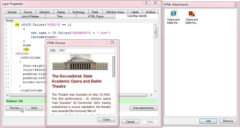
55 HTML layouts for Identify tool CarryMap allows specifying HTML layouts for each layer in the map. Choose Layer properties in ArcMap and open the "CarryMap Identify" tab. The default script contains Identify dialog style and imaging. Default script: Adding an image to Identify dialog Type the following expression to the default script to add an image: <% var tag = '<img src="'; tag += CF.Values["Name"] + ".jpg"; tag += '">';
![echo (tag); %> where: CF.Values["Name"] + ".jpg" - forms the name of the picture file attached. ["Name"] - field name taken from image description.](/docs-images/77/76081649/images/56-0.jpg "Therefore, when the current feature has, for example, \"Lynx\" value, then the file name should be \"Lynx.jpg\".")
56 echo (tag); %> where: CF.Values["Name"] + ".jpg" - forms the name of the picture file attached. ["Name"] - field name taken from image description. Therefore, when the current feature has, for example, "Lynx" value, then the file name should be "Lynx.jpg". This file should be attached to the map: Please, note that feature class should have a "Name" field. Adding an image and a text to Identify dialog Text can be saved as a.txt file. Type the following expression to the default script: <% var tag = '<img src="';
57 tag += CF.Values["Name"] + ".jpg"; %> tag += '">'; var name = CF.Values["Name"] + " description.txt"; echo (tag); include(name); where: var name = CF.Values["Name"] + " description.txt" - forms the name of the text file attached. Therefore, we have "Lynx" + "description.txt" = "Lynx description.txt". This file should be attached to the map: Please, note that if feature class doesn't have "Name" field or the description/image file is not attached to the map, this feature will not work.
 Adding HTML to Identify dialog")
58 Preview CarryMap Identify dialog in ArcMap You can view the script result in ArcMap by pressing "Preview" button, no need to convert the map to check it. The picture and the text for a particular feature will be displayed when you have entered OBJECTID (FID value for shapefile; OID value for geodatabase feature class) Adding HTML to Identify dialog Add the following expression to the default script: <% if(cf.values["html"] == 1) { var name = CF.Values["ADDRESS"] + ".htm"; include(name); }
59 else {%> where: if(cf.values["html"] == 1) "HTML"=1 - field value. var name = CF.Values["ADDRESS"] + ".htm" - forms the name of the HTML file attached. Expression value: if HTML field value is 1, then HTML file with the name formed from "ADDRESS" field will be displayed. Otherwise, the field values from default script will be used. HTML file and associated images should be attached to the map: Preview HTML document in ArcMap HTML file for a particular feature will be displayed when you have entered OBJECTID (FID value for shapefile; OID value for geodatabase feature class)
60 ---
61 Pushpins Mobile CarryMap maps versions allow collecting point data by adding pushpins to the maps. To add a pushpin to your map choose the flag button on the right. Click on the place on the map where you want to pin a pushpin, you will see the Pushpin edit dialog.

62 You can choose one of the ten colors of pushpins by clicking on the red flag in the dialog.

63 Add a name and description for the pushpin in this dialog and click "OK".
64 You will see the pushpin on your map. If you click on it, the information dialog will appear. You can edit or delete a pushpin.
65 Pushpins can be added for current GPS location with a right-click of a mouse.
66 Besides, CarryMap provides an option of adding a pushpin using the Identification dialog. To do this press the Add pushpin button in the appropriate feature identification dialog.
67 Once you have added your pushpins, you can then export them to the KML file and share. Choose "Export" option in the mobile map settings dialog:

68 Save the data in the appropriate folder.

69 When the export process is finished, click "OK".

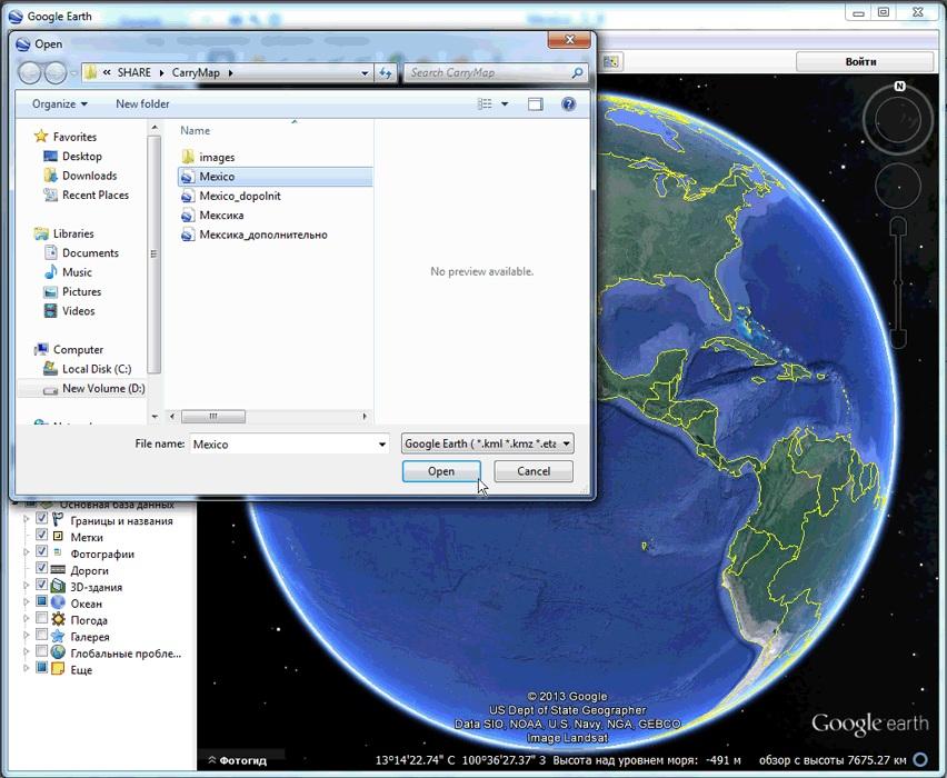
70 Then you can open your.kml file in Google Earth application, for example:
71

72 Geotransformation is considered when exporting pushpins to kml (kmz). You can also import your pushpins from one mobile map to another. Choose "Import" in the map settings dialog.
73 Choose the pushpins you want to add to your map.
74 Once Import is finished, click "OK".
75 Pushpins from another mobile map are now on the current map.
76 ---
77 Data Import CarryMap 3.x versions allow importing mobile map data (with added pushpins) back to ArcGIS. Choose "Import mobile map" option in the CarryMap toolbar menu: Please note that data import is impossible, if the option "Allow import to ArcGIS" was not chosen during the map extraction (see Protecting output maps). Choose the mobile map file you want to import and a geodatabase with map data: Press "Import" to start the process:

78 All the data from the mobile map is now in a geodatabase accompanied with an ArcMap document.
79 ---
80

81 Specifying CarryMap settings With CarryMap 3.x you can specify the default CarryMap settings which include: Interface language Default parameters for the extraction wizard express mode Interface languages - Currently there are three languages supported, English, Russian and Brazilian Portuguese. Default parameters - For the express mode you can pre-define: - Map description for the output maps - Protection properties - Raster properties - Watermarks properties - Map skin and logo ---
82
83 Registration Data East CarryMap for ArcGIS is a shareware product. Trial version is available for 14 days, after the trial period you can purchase a full license. To register CarryMap: Visit the CarryMap section at the Data East on-line GIS store Go to the registration form Fill the registration form and pay with a credit card After payment verification you will receive a license key via provided Enter provided license key to the registration form which is available from the About dialog window ---
84
85 Technical Support Any problems, questions, or comments on using CarryMap can be addressed to: For online support resources that include product descriptions, download, CarryMap gallery and other product related information, please visit the CarryMap section at the Data East site: ---
Data East, LLC. Using CarryMap mobile maps on ios devices (iphones, ipads, ipods touch)
") Data East, LLC Using CarryMap mobile maps on ios devices (iphones, ipads, ipods touch) TABLE OF CONTENTS 1. Downloading map files to mobile device... 3 1.1 Copy.cmf file to CarryMap Observer mobile application
Data East, LLC Using CarryMap mobile maps on ios devices (iphones, ipads, ipods touch) TABLE OF CONTENTS 1. Downloading map files to mobile device... 3 1.1 Copy.cmf file to CarryMap Observer mobile application
CACHE ESRI MAPS TO MOBILE DEVICES
 CACHE ESRI MAPS TO MOBILE DEVICES Company Overview & History Lake Country Power is a Touchstone Energy Cooperative serving parts of eight counties in Aitkin, Carlton, Cass, Itasca, Koochiching, Lake, Pine
Geographical Information Systems Institute. Center for Geographic Analysis, Harvard University. LAB EXERCISE 1: Basic Mapping in ArcMap
 Harvard University Introduction to ArcMap Geographical Information Systems Institute Center for Geographic Analysis, Harvard University LAB EXERCISE 1: Basic Mapping in ArcMap Individual files (lab instructions,
Functionality of CarryMap 5.2 application for Android devices
 Data East, LLC Functionality of CarryMap 5.2 application for Android devices Content Overview of buttons located on map window... 3 Creating new object... 3 Adding photo to object... 7 Measuring distance
Press the Plus + key to zoom in. Press the Minus - key to zoom out. Scroll the mouse wheel away from you to zoom in; towards you to zoom out.
 Navigate Around the Map Interactive maps provide many choices for displaying information, searching for more details, and moving around the map. Most navigation uses the mouse, but at times you may also
RAPIDMAP Geocortex HTML5 Viewer Manual
 RAPIDMAP Geocortex HTML5 Viewer Manual This site was developed using the evolving HTML5 web standard and should work in most modern browsers including IE, Safari, Chrome and Firefox. Even though it was
Juniata County, Pennsylvania
 GIS Parcel Viewer Web Mapping Application Functional Documentation June 21, 2017 Juniata County, Pennsylvania Presented by www.worldviewsolutions.com (804) 767-1870 (phone) (804) 545-0792 (fax) 115 South
Advanced PDF features
 1 of 7 2/17/2009 10:56 PM Show Navigation Hide Navigation You are here: Mapping and v isualization > Page layout and map composition > Map output Advanced PDF features Release 9.3 Last modified November
Importing GPS points and Hyperlinking images.
 Geol 3050 GIS for Geologists Exercise 15 Exercise 15 Making a Virtual Fieldtrip: Importing GPS points and Hyperlinking images. Due: Thursday, March 22. Goal: A) Get familiar with importing GPS points and
HCA ArcGIS. Online Tool - How To Guide V1.0 2/15/2016 HAWAII CONSERVATION ALLIANCE AGOL
 HCA ArcGIS 2/15/2016 Online Tool - How To Guide V1.0 HAWAII CONSERVATION ALLIANCE AGOL Table of Contents What is ArcGIS Online?... 1 Getting Started... 1 Getting a Login... 1 Logging In... 2 Searching
Exercise 1: An Overview of ArcMap and ArcCatalog
 Exercise 1: An Overview of ArcMap and ArcCatalog Introduction: ArcGIS is an integrated collection of GIS software products for building a complete GIS. ArcGIS enables users to deploy GIS functionality
Geography 281 Mapmaking with GIS Project One: Exploring the ArcMap Environment
 Geography 281 Mapmaking with GIS Project One: Exploring the ArcMap Environment This activity is designed to introduce you to the Geography Lab and to the ArcMap software within the lab environment. Please
Geography 281 Mapmaking with GIS Project One: Exploring the ArcMap Environment
 Geography 281 Mapmaking with GIS Project One: Exploring the ArcMap Environment This activity is designed to introduce you to the Geography Lab and to the ArcMap software within the lab environment. Before
GIS IN ECOLOGY: CREATING RESEARCH MAPS
 GIS IN ECOLOGY: CREATING RESEARCH MAPS Contents Introduction... 2 Elements of Cartography... 2 Course Data Sources... 3 Tasks... 3 Establishing the Map Document... 3 Laying Out the Map... 5 Exporting Your
Chapter 5. Presenting Data
 Chapter 5. Presenting Data Copyright McGraw-Hill Education. Permission required for reproduction or display. 5-1 Map Design Process 5-2 1 About ArcGIS Chapter 5. Presenting Data 5-3 Page layouts and map
ENERGY WEB ATLAS WEB APPLICATION USER GUIDE. ENERGY WEB ATLAS All materials subject to strictly enforced copyright laws Gulf Publishing Company 1
 ENERGY WEB ATLAS WEB APPLICATION USER GUIDE ENERGY WEB ATLAS All materials subject to strictly enforced copyright laws Gulf Publishing Company 1 WELCOME Welcome to the Energy Web Atlas User Guide. Choose
ArcGIS Extension User's Guide
 ArcGIS Extension 2010 - User's Guide Table of Contents OpenSpirit ArcGIS Extension 2010... 1 Installation ( ArcGIS 9.3 or 9.3.1)... 3 Prerequisites... 3 Installation Steps... 3 Installation ( ArcGIS 10)...
GIS Basics for Urban Studies
 GIS Basics for Urban Studies Date: March 21, 2018 Contacts: Mehdi Aminipouri, Graduate Peer GIS Faciliator, SFU Library (maminipo@sfu.ca) Keshav Mukunda, GIS & Map Librarian Librarian for Geography (kmukunda@sfu.ca)
Exercise 1: Getting to know ArcGIS
 The Scenario You are working for the California Visitor s Commission. You have been asked to prepare a map of California for several dignitaries from out of the country. Your map will need to include enough
Guide to Mapping Website (Public) December 2016 GC_236594
 December 2016 GC_236594") Guide to Mapping Website (Public) December 2016 GC_236594 Table of Contents Guide to Mapping Website (Public)... 1 December 2016... 1 Quick Start... 3 Map Layers... 4 How do I?... 5 Draw on the Map...
Guide to Mapping Website (Public) December 2016 GC_236594 Table of Contents Guide to Mapping Website (Public)... 1 December 2016... 1 Quick Start... 3 Map Layers... 4 How do I?... 5 Draw on the Map...
What s New in Desktop 10.1
 What s New in Desktop 10.1 Damian Spangrud Esri Redlands Trip Down Memory Lane ArcGIS A Complete System for Geographic Information Cloud Web Online Mobile Enterprise Desktop Sharing Information sharing
ENERGY WEB ATLAS WEB APPLICATION USER GUIDE. ENERGY WEB ATLAS All materials subject to strictly enforced copyright laws Gulf Publishing Company 1
 ENERGY WEB ATLAS WEB APPLICATION USER GUIDE ENERGY WEB ATLAS All materials subject to strictly enforced copyright laws Gulf Publishing Company 1 WELCOME Welcome to the Energy Web Atlas User Guide. Choose
Page 1 of 16 CONTENTS:
 Page 1 of 16 CONTENTS: HOME-BOX -- (PG.2) o PROPERTY OWNERSHIP o ADDRESS SEARCH o I WANT TO AERIAL IMAGERY AND BASE MAPS -- (PG.2) o IMAGERY WITH LABELS ON/OFF o TOPOGRAPHY ON/OFF o TRANSPARENCY ZOOM IN
SAGIS Property Map Viewer Instruction Manual Instructions for using the SAGIS Property Map Viewer. Published December 21, 2018.
 SAGIS Property Map Viewer Instruction Manual www.sagis.org/map Instructions for using the SAGIS Property Map Viewer. Published December 21, 2018. 1 Instructional Videos Click on a link to watch a video
SAS Report Viewer 8.3 Documentation
 SAS Report Viewer 8.3 Documentation About SAS Report Viewer Introduction to SAS Report Viewer SAS Report Viewer (the report viewer) enables users who are not report designers to view a report using a web
Review of File Management and Introduction to ArcGIS
 Review of File Management and Introduction to ArcGIS RNR/GEOG 417/517 Overview of Presentation Discuss the objectives of the lab exercise Introduce the class directory structure General file policies Introduce
ArcGIS. for Desktop. Tips and Shortcuts 10.1
 ArcGIS 10.1 for Desktop Tips and Shortcuts Map Navigation Refresh and redraw the display. F5 Suspend the map s drawing. F9 Zoom in and out. Center map. Roll the mouse wheel backward and forward. Hold down
OnCOR Silverlight Viewer Guide
 Getting Around There are many ways to move around the map! The simplest option is to use your mouse in the map area. If you hold the left button down, then click and drag, you can pan the map to a new
Basic Tasks in ArcGIS 10.3.x
 Basic Tasks in ArcGIS 10.3.x This guide provides instructions for performing a few basic tasks in ArcGIS 10.3.1, such as adding data to a map document, viewing and changing coordinate system information,
Chapter 1 : Getting Started with Integrity... Chapter 2 : Interface Layout... Chapter 3 : Navigation... Chapter 4 : Printing...
 .0 User s Manual Table of Contents Chapter : Getting Started with Integrity... Chapter : Interface Layout... Chapter : Navigation... Chapter : Printing... Chapter : Quick Search and Results Pane... Results
Explore some of the new functionality in ArcMap 10
 Explore some of the new functionality in ArcMap 10 Scenario In this exercise, imagine you are a GIS analyst working for Old Dominion University. Construction will begin shortly on renovation of the new
ArcMap Editing Tips and Tricks. Sean Jones
 ArcMap Editing Tips and Tricks Sean Jones Overview Topics - Tuning your editing map - Creating features - Editing features and attributes - Aligning and editing coincident features - Addins Format - Software
ArcGIS. ArcGIS Desktop. Tips and Shortcuts
 ArcGIS ArcGIS Desktop Tips and Shortcuts Map Navigation Function Shortcut Availability Refresh and redraw the display. F5 9.1, Suspend the map s drawing. F9 9.1, Zoom in and out. Center map. Roll the mouse
Edge App User Guide V 4.5
 Edge App User Guide V 4.5 Table of Contents Introduction... 4 Trial Version... 4 Logging In... 5 1. Home... 7 2. View Notes... 8 2.1. View Notes List & Tab View... 8 2.2. View Notes Map View... 17 3. View
Release Notes. Spectrum Spatial Analyst Version 8.0. Contents:
 Location Intelligence Spectrum Spatial Analyst Version 8.0 This document contains information about Pitney Bowes Spectrum Spatial Analyst Release 8.0. Contents: What s new in Spectrum Spatial Analyst?
Tutorial 1 Exploring ArcGIS
 Tutorial 1 Exploring ArcGIS Before beginning this tutorial, you should make sure your GIS network folder is mapped on the computer you are using. Please refer to the How to map your GIS server folder as
v Annotation Tools GMS 10.4 Tutorial Use scale bars, North arrows, floating images, text boxes, lines, arrows, circles/ovals, and rectangles.
 v. 10.4 GMS 10.4 Tutorial Use scale bars, North arrows, floating images, text boxes, lines, arrows, circles/ovals, and rectangles. Objectives GMS includes a number of annotation tools that can be used
Overview of ArcGIS Online Applications. Champaign County
 Overview of ArcGIS Online Applications Champaign County Champaign County GIS Consortium Updated: April 2017 Table of Contents ArcGIS Online Application Overview... 3 Map Interface Symbology and Terminology...
Making a Sackville Coastal Flood Map
 Making a Sackville Coastal Flood Map Demo covers: Accessing and previewing map templates Modifying map elements such as titles, data frames, legends & scale bars Drawing a graphic on a map Adding text
Open Source Cloud Map User Guide
 Open Source Cloud Map User Guide Table of Contents Map Page... 1 Static Mercator Map... 1 Customizable Map... 1 Title Bar... 2 Toolbar... 2 Non Toolbar Navigation... 3 Map Window... 3 Layers / Legend Window...
End User Guide. 2.1 Getting Started Toolbar Right-click Contextual Menu Navigation Panels... 2
 TABLE OF CONTENTS 1 OVERVIEW...1 2 WEB VIEWER DEMO ON DESKTOP...1 2.1 Getting Started... 1 2.1.1 Toolbar... 1 2.1.2 Right-click Contextual Menu... 2 2.1.3 Navigation Panels... 2 2.1.4 Floating Toolbar...
Getting Started with the new GIS Map Service Overview:
 Getting Started with the new GIS Map Service Overview: 1. Layer List Widget Shows all available layers. This widget will be open by default. 2. Legend Widget Gives symbology information for all visible
Intro to GIS (requirements: basic Windows computer skills and a flash drive)
") Introduction to GIS Intro to GIS (requirements: basic Windows computer skills and a flash drive) Part 1. What is GIS. 1. System: hardware (computers, devices), software (proprietary or free), people. 2.
Introduction to GIS Intro to GIS (requirements: basic Windows computer skills and a flash drive) Part 1. What is GIS. 1. System: hardware (computers, devices), software (proprietary or free), people. 2.
Chapter 7. A Quick Tour of ArcGIS Pro
 Chapter 7 A Quick Tour of ArcGIS Pro Skills you will learn: This tutorial is intended to get you going using ArcGIS Pro, a new desktop application that is part of ArcGIS Desktop. A separate tutorial gives
INTRODUCTION TO GIS WORKSHOP EXERCISE
 111 Mulford Hall, College of Natural Resources, UC Berkeley (510) 643-4539 INTRODUCTION TO GIS WORKSHOP EXERCISE This exercise is a survey of some GIS and spatial analysis tools for ecological and natural
This user guide covers select features of the desktop site. These include:
 User Guide myobservatory Topics Covered: Desktop Site, Select Features Date: January 27, 2014 Overview This user guide covers select features of the desktop site. These include: 1. Data Uploads... 2 1.1
Creating Presentations with Prezi
 Creating Presentations with Prezi This document provides an introduction to using Prezi to create presentations. Prezi is a webbased tool that allows users to create a presentation using a map layout.
Web Viewer Guide. HiPER LOOK Version Copyright 2016 PIXIA Corp. All Rights Reserved.
 Web Viewer Guide 2016 HiPER LOOK Version 1.4.16.0 Copyright 2016 PIXIA Corp. All Rights Reserved. Table of Contents 1 System Requirements... 5 1.1 Prerequisites... 5 1.2 Web Browser... 5 2 HiPER LOOK Web
ArcGIS Desktop: Fundamentals of Cartography
 ArcGIS Desktop: Fundamentals of Cartography Outline Symbology Style Files -.style Layer files -.lyr Labeling Label Classes Label Expressions Map Document files -.mxd Map Template files -.mxt Map Elements
Create a personal geodatabase
 Create a personal geodatabase To create a personal geodatabase that corresponds to the same release as the ArcGIS for Desktop client you are using, follow these steps: 1. In ArcCatalog, right-click the
How to Create a Tile Package
 United States Department of Agriculture Digital Mobile Sketch Mapping (DMSM) How to Create a Tile Package (TPK) Forest Service Introduction A tile package (.tpk) allows you to use a set of packaged tiles
Reader Release Notes. January 7, Release version: 3.1
 Reader Release Notes January 7, 2019 Release version: 3.1 MindManager Reader Version 3.1... 2 General Information... 2 New in Version 3.1... 2 Supported Features... 2 Elements... 2 Text... 3 Navigation...
Getting Started with GIS using ArcGIS 10.6 What is GIS? and - Module 1 Creating a map document
 Getting Started with GIS using ArcGIS 10.6 What is GIS? and - Module 1 Creating a map document Marcel Fortin Map & Data Library mdl@library.utoronto.ca 2018 http://mdl.library.utoronto.ca This workshop
Prezi Creating a Prezi
 Prezi Creating a Prezi Log in to your account and click on the New Prezi button. Enter a title and (optional) description, and then click on the Create New Prezi button. Selecting a Template Select a template.
FAQ & Troubleshooting
 FAQ & Troubleshooting What is the most common issue users have when using the site? Pop-Up Blocker!!! Any link external to the viewer requires a new window to be opened in the browser. See My map or report
Introduction to GIS & Mapping: ArcGIS Desktop
 Introduction to GIS & Mapping: ArcGIS Desktop Your task in this exercise is to determine the best place to build a mixed use facility in Hudson County, NJ. In order to revitalize the community and take
Tutorial for Importing Open Green Map Sites into Google Earth
 Tutorial for Importing Open Green Map Sites into Google Earth Step 1. Download your Open Green Map data files by logging in on Open Green Map and viewing your map(s). Choose the Import/Export tab over
Release Notes. MapInfo Stratus Version 44. Contents: This document contains information about Pitney Bowes MapInfo Stratus Release 44.
 Location Intelligence MapInfo Stratus Version 44 This document contains information about Pitney Bowes MapInfo Stratus Release 44. Contents: What s new in MapInfo Stratus? What s new in Mobile Ready User
From Data to Map in 30 Minutes. Aileen Buckley, PhD
 From Data to Map in 30 Minutes Aileen Buckley, PhD This session Crater Lake online map From NPS: https://www.nps.gov/carto/hfc/carto/media/crlamap1.pdf Download Crater Lake map packages here: ArcGIS Pro
GPS TO GIS EXERCISE (30 PTS)
") GPS TO GIS EXERCISE (30 PTS) This exercise will allow you to demonstrate your cumulative knowledge of using a GPS receiver to collect data with locational information, downloading this data to a desktop
GPS TO GIS EXERCISE (30 PTS) This exercise will allow you to demonstrate your cumulative knowledge of using a GPS receiver to collect data with locational information, downloading this data to a desktop
GeoWeb Portal. User Manual
 GeoWeb Portal User Manual Purpose The GeoWeb Portal (GWP) is a map viewing and publishing site. It is designed to allow people to build their own maps and review the data that is attached to the elements
Welcome to the Surface Water Data Viewer!
 1 Welcome to the Surface Water Data Viewer! The Surface Water Data Viewer is a mapping tool for the State of Wisconsin. It provides interactive web mapping tools for a variety of datasets, including chemistry,
ArcGIS. ArcGIS Desktop. Tips and Shortcuts
 ArcGIS ArcGIS Desktop Tips and Shortcuts Map Navigation Refresh and redraw the display. F5 9.1, Suspend the map s drawing. F9 9.1, Zoom in and out. Center map. Roll the mouse wheel backward and forward.
What s New AccessVia Publishing Platform Features and Improvements
 ACCESSVIA 3131 Western Avenue #530 Seattle WA 98121.1028 +1.206.285.4994 www.accessvia.com What s New AccessVia Publishing Platform Features and Improvements v8.5.265 to v8.6.272 May 8, 2014 Overview New
National Monuments Service: Wreck Database Viewer
 National Monuments Service: Wreck Database Viewer Introduction HELP DOCUMENT Welcome to the Wreck Viewer map / search facility that provides access to the records of wrecks held by the National Monuments
User Manual Mobile client User Interface Version 5.0. Powered by
 User Manual Mobile client User Interface Version 5.0 Powered by Cartographic browser Gomap 4 1 Access control 5 1.1 Public access 5 1.2 Secured access 5 1.3 Multiple applications 5 2 Organisation 6 3 Parameters
MANITOBA LAND USE AND DEVELOPMENT WEB APPLICATION: How-to guide and help document
 MANITOBA LAND USE AND DEVELOPMENT WEB APPLICATION: How-to guide and help document 2 Index Index... 2 Layout & View... 3 Overview... 3 Layers... 4 Municipal Relations Data Layers... 4 Application Toolbar...
The ArcMap Interface and Using Basic ArcMap Analysis Tools to Create a Map
 The ArcMap Interface and Using Basic ArcMap Analysis Tools to Create a Map *You will need a computer with ESRI ArcGIS Desktop version 9.3 or higher installed* Data Download 1. Save the zipped folder with
The Preparing for Success Online Mapping Tool
 The Preparing for Success Online Mapping Tool Baker Polito Administration The Executive Office of Housing and Economic Development and MassGIS Questions & Comments? Please contact MassWorks@state.ma.us
Tutorial 01 Quick Start Tutorial
 Tutorial 01 Quick Start Tutorial Homogeneous single material slope No water pressure (dry) Circular slip surface search (Grid Search) Intro to multi scenario modeling Introduction Model This quick start
Getting Started With LP360
 Getting Started With LP360 12/22/2015 1 Contents What is LP360?... 3 System Requirements... 3 Installing LP360... 4 How to Enable the LP360 Extension... 4 How to Display the LP360 Toolbar... 4 How to Import
TRAINING GUIDE. Mobile for Administrators Part 3 - GIS
 TRAINING GUIDE Mobile for Administrators Part 3 - GIS Mobile for Administrators - GIS One of the critical components of mobile is GIS, and it can also be the most complex. The mobile GIS maps are designed
TRAINING GUIDE. Tablet Cradle to Mobile GIS
 TRAINING GUIDE Tablet Cradle to Mobile GIS Tablet Cradle to Mobile One of the critical components of mobile is the GIS piece, and also can be the most complex. The mobile GIS maps are designed to consume
v Getting Started An introduction to GMS GMS Tutorials Time minutes Prerequisite Tutorials None
 v. 10.3 GMS 10.3 Tutorial An introduction to GMS Objectives This tutorial introduces GMS and covers the basic elements of the user interface. It is the first tutorial that new users should complete. Prerequisite
No Programming Required Create web apps rapidly with Web AppBuilder for ArcGIS
 No Programming Required Create web apps rapidly with Web AppBuilder for ArcGIS By Derek Law, Esri Product Manager, ArcGIS for Server Do you want to build web mapping applications you can run on desktop,
Using Google Earth. Middlebury College Library and Information Services
 Using Google Earth Middlebury College Introduction: While Google Earth can be a fun tool for simply looking at the surface of the earth, there are many other more sophisticated features to explore. Google
Password Memory 7 User s Guide
 C O D E : A E R O T E C H N O L O G I E S Password Memory 7 User s Guide 2007-2018 by code:aero technologies Phone: +1 (321) 285.7447 E-mail: info@codeaero.com Table of Contents How secure is Password
Interactive Maps Purpose: Login to the System: Interactive Maps ONTINUE AGREE
 Interactive Maps Purpose: The purpose of this application is to provide the facility to the citizen to navigate to a Property through an On-line Free Web Application in real time. The application uses
Geography 281 Map Making with GIS Project Two: Map Design Issues in ArcMap
 Geography 281 Map Making with GIS Project Two: Map Design Issues in ArcMap This activity provides an introduction to the map design process. It takes you through a typical sequence from the initial decision
US Geo-Explorer User s Guide. Web:
 US Geo-Explorer User s Guide Web: http://usgeoexplorer.org Updated on October 26, 2016 TABLE OF CONTENTS Introduction... 3 1. System Interface... 5 2. Administrative Unit... 7 2.1 Region Selection... 7
Pictometry for ArcGIS Desktop Local Release Notes
 Version 10.4 The Desktop - Local 10.4 extension is compatible with ArcGIS Desktop 10.4. Version 10.3.2 This extension includes a new installer, which allows you to select a location (other than Program
KODAK Software User s Guide
 KODAK Create@Home Software User s Guide Table of Contents 1 Welcome to KODAK Create@Home Software Features... 1-1 Supported File Formats... 1-1 System Requirements... 1-1 Software Updates...1-2 Automatic
All data is in Universal Transverse Mercator (UTM) Zone 6 projection, and WGS 84 datum.
 Zone 6 projection, and WGS 84 datum.") 111 Mulford Hall, College of Natural Resources, UC Berkeley (510) 643-4539 EXPLORING MOOREA DATA WITH QUANTUM GIS In this exercise, you will be using an open-source FREE GIS software, called Quantum GIS,
111 Mulford Hall, College of Natural Resources, UC Berkeley (510) 643-4539 EXPLORING MOOREA DATA WITH QUANTUM GIS In this exercise, you will be using an open-source FREE GIS software, called Quantum GIS,
Estuary Data Viewer User Guide
 1. Introduction 2. Page Layout 3. Navigation Tools 4. Table of Contents Tabs 5. Action Tools 6. System Requirements Estuary Data Viewer User Guide 1. Introduction Welcome to the Estuary Planner Data Viewer.
In order to follow this set of directions you will need the following
 How to Create Maps & Figures in ArcView 9x In order to follow this set of directions you will need the following 1) the Jenny s Louisiana GIS Instructional CD 2) a computer with ArcGIS on it (version 9.0
GEOG4017 Geographical Information Systems Lab 3 Data Collection and Integration (I)
") DEPARTMENT OF GEOGRAPHY HONG KONG BAPTIST UNIVERSITY Prof. Q. Zhou GEOG4017 Geographical Information Systems Lab 3 Data Collection and Integration (I) Objectives Before we can use GIS for any analysis
DEPARTMENT OF GEOGRAPHY HONG KONG BAPTIST UNIVERSITY Prof. Q. Zhou GEOG4017 Geographical Information Systems Lab 3 Data Collection and Integration (I) Objectives Before we can use GIS for any analysis
Biodiversity GIS (BGIS) Internet Mapping User Guide
 Internet Mapping User Guide") Biodiversity GIS (BGIS) Internet Mapping User Guide http://bgis.sanbi.org Contents 1 Basic Introduction to BGIS Website (http://bgis.sanbi.org)... 6 1.1 LUDS... 6 1.2 Projects... 6 1.3 Services... 6 1.4
Biodiversity GIS (BGIS) Internet Mapping User Guide http://bgis.sanbi.org Contents 1 Basic Introduction to BGIS Website (http://bgis.sanbi.org)... 6 1.1 LUDS... 6 1.2 Projects... 6 1.3 Services... 6 1.4
User Guide. BlackBerry Workspaces for Windows. Version 5.5
 User Guide BlackBerry Workspaces for Windows Version 5.5 Published: 2017-03-30 SWD-20170330110027321 Contents Introducing BlackBerry Workspaces for Windows... 6 Getting Started... 7 Setting up and installing
KODAK Software User s Guide. Software Version 9.0
 KODAK Create@Home Software User s Guide Software Version 9.0 Table of Contents 1 Welcome to KODAK Create@Home Software Features... 1-1 Supported File Formats... 1-1 System Requirements... 1-1 Software
TRAINING GUIDE. Tablet: Cradle to Mobile GIS
 TRAINING GUIDE Tablet: Cradle to Mobile GIS Tablet Cradle to Mobile One of the critical components of mobile is the GIS piece, and also can be the most complex. The mobile GIS maps are designed to consume
STUDENT PAGES GIS Tutorial Treasure in the Treasure State
 STUDENT PAGES GIS Tutorial Treasure in the Treasure State Copyright 2015 Bear Trust International GIS Tutorial 1 Exercise 1: Make a Hand Drawn Map of the School Yard and Playground Your teacher will provide
In this exercise, you will convert labels into geodatabase annotation so you can edit the text features.
 Instructions: Use the provided data stored in a USB. For the report: 1. Start a new word document. 2. Follow an exercise step as given below. 3. Describe what you did in that step in the word document
Full Search Map Tab. This map is the result of selecting the Map tab within Full Search.
 Full Search Map Tab This map is the result of selecting the Map tab within Full Search. This map can be used when defining your parameters starting from a Full Search. Once you have entered your desired
Development Authority of the North Country (DANC) Internet Mapping Application Instructions Public Viewer 1. Purpose. 2. Logging-in. 3.
 Internet Mapping Application Instructions Public Viewer 1. Purpose. 2. Logging-in. 3.") Development Authority of the North Country (DANC) Internet Mapping Application Instructions Public Viewer 1. Purpose The purpose of this document is to outline basic functionality of the DANC Internet
Development Authority of the North Country (DANC) Internet Mapping Application Instructions Public Viewer 1. Purpose The purpose of this document is to outline basic functionality of the DANC Internet
COGCC GIS Online Map Instructions - Internet Site April 10, 2018
 COGCC GIS Online Map Instructions - Internet Site April 10, 2018 Table of Contents Page Section Page Section 1 Introduction 8 Clear Selection 2 Double Click 8 Buffer 3 Arrow Tip Information 9 Select within
Movavi PDF Editor User Guide. Quick start guide Opening files Editing documents Saving files
 Movavi PDF Editor User Guide Quick start guide Opening files Editing documents Saving files Table of Contents Quick start guide...2 Removing trial restrictions...3 Getting an activation key...4 Activating
Video Management Software
 Video Management Software User Manual Web: europesecurity.eu Mail: info@europesecurity.eu Tel.: 0541 352 952 User s Manual 2 Contents CHAPTER : XMS CENTRAL USER MANUAL 1 PC REQUIREMENT 3 2 INSTALL 3 3
for ArcSketch Version 1.1 ArcSketch is a sample extension to ArcGIS. It works with ArcGIS 9.1
 ArcSketch User Guide for ArcSketch Version 1.1 ArcSketch is a sample extension to ArcGIS. It works with ArcGIS 9.1 ArcSketch allows the user to quickly create, or sketch, features in ArcMap using easy-to-use
InDesign Part II. Create a Library by selecting File, New, Library. Save the library with a unique file name.
 InDesign Part II Library A library is a file and holds a collection of commonly used objects. A library is a file (extension.indl) and it is stored on disk. A library file can be open at any time while
1. AUTO CORRECT. To auto correct a text in MS Word the text manipulation includes following step.
 1. AUTO CORRECT - To auto correct a text in MS Word the text manipulation includes following step. - STEP 1: Click on office button STEP 2:- Select the word option button in the list. STEP 3:- In the word