Motivation. Large number of bridges and road structures. In the US, > 600,000 bridges. Large number of aging structures
|
|
|
- Frederica Davis
- 5 years ago
- Views:
Transcription
1

2 Motivation Bridge Capacity Population Density I- 55 Thomas St I- 40 Walnut Grove Rd I- 240 US Hwy 70 S Germantown Rd Large number of bridges and road structures In the US, > 600,000 bridges E Shelby Dr Miles Large number of aging structures In the US, 1/9 is classified as structurally deficient
3 Motivation ~ 500,000 bridge inspections/year across the EU and the US
4 Motivation Bridge Inspection Challenges: A lot of data Or No data


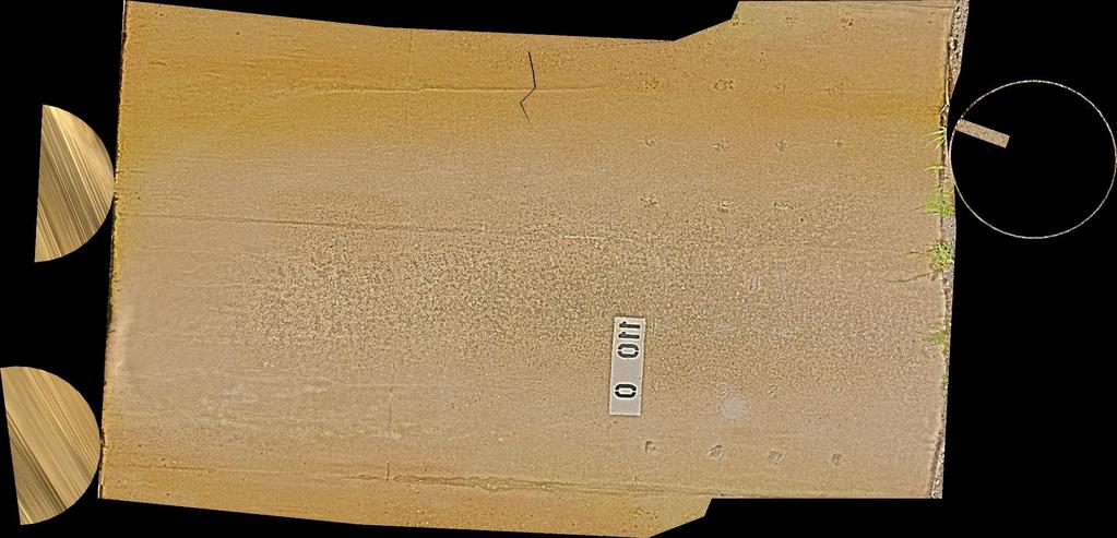
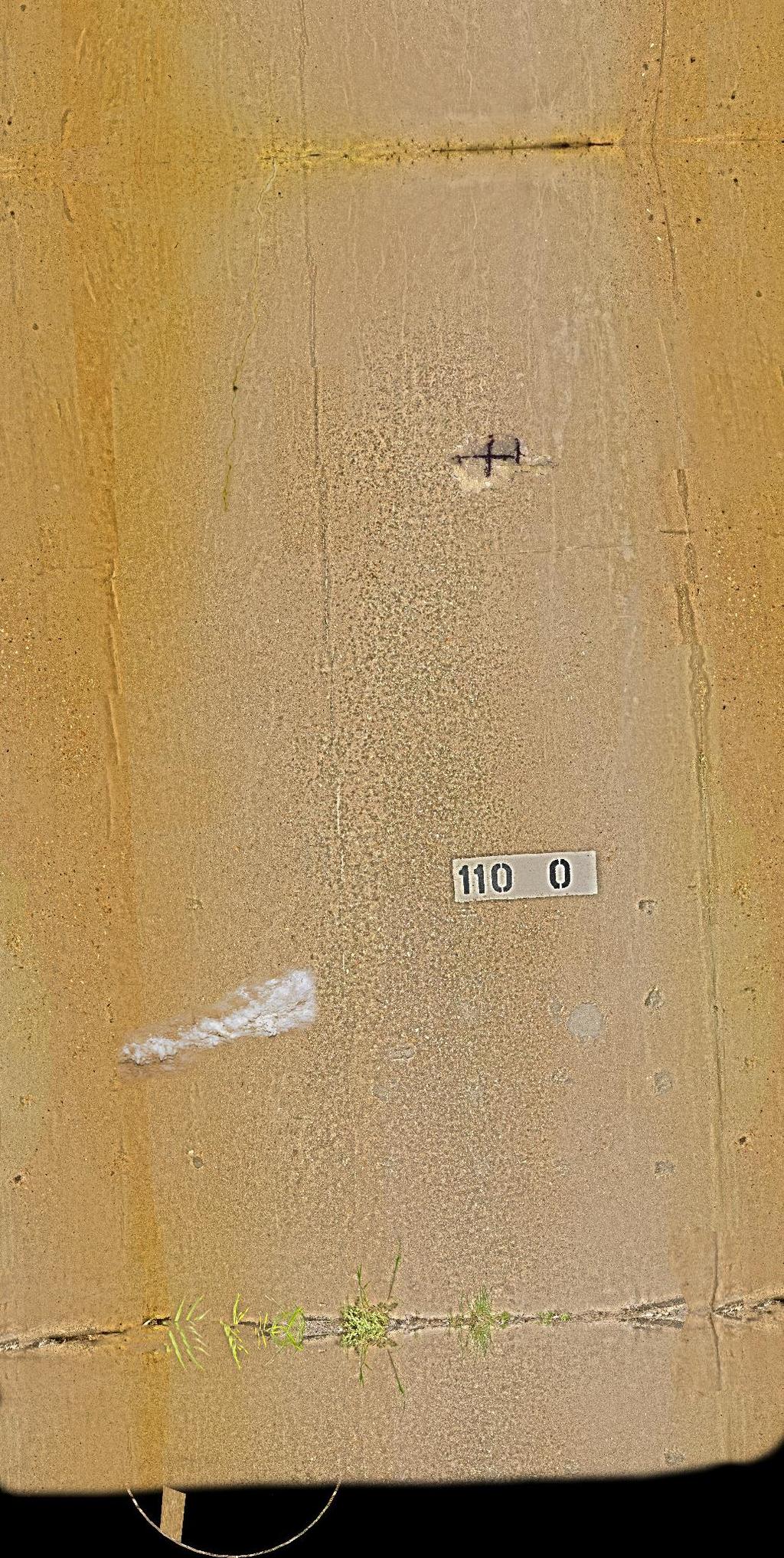
5 Motivation Bridge Inspection Challenges: Constant need for detailed, updated data throughout the bridge s lifetime New data should be comparable with old Abutment A Scale: 1:200/100

6 Motivation Bridge Inspection Challenges: Minimize Cost vs. Maximize service level

7 Bridge management The challenge Bridge management is a complex process


8 Motivation Almost all BMS are tabular based and hard to manage. Most of them present a similar architectural framework. Some have better bridge visualization.
9 Motivation Bridge management process Theoretical background Historical data archiving PMS, SMS output Designing bridge Rehab. and Maint. works BMS establishment BMS processing Maintenance management System Maint./rerahb. Project Inspectors recruiting and training Performing Inspections Additional study (NDT/Monitoring) Bridge Maint./Rehab. contractors

10 Overview SeeBridge is an acronym for Semantic Enrichment Engine for Bridges a proposed process for automatically compiling BIM models of existing concrete highway bridges that includes precise information about their components, geometry and surface defects Automated Compilation of Semantically Enriched BIM models of Bridges


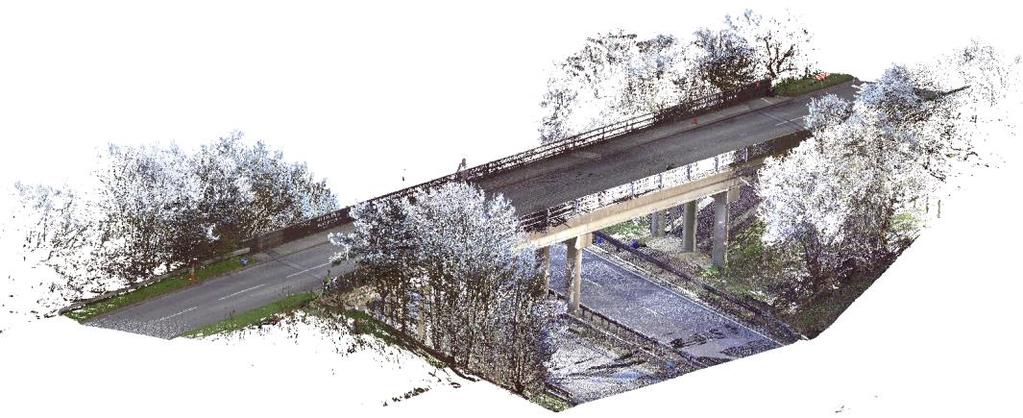
11 Overview First, SeeBridge uses laser/photogrammetry to survey a bridge.


12 Overview Then, SeeBridge does 3D geometry reconstruction.

13 Overview Next, SeeBridge does Semantic Enrichment. Deck slab Shear keys Girder Column Transverse beam Abutment Capping beam

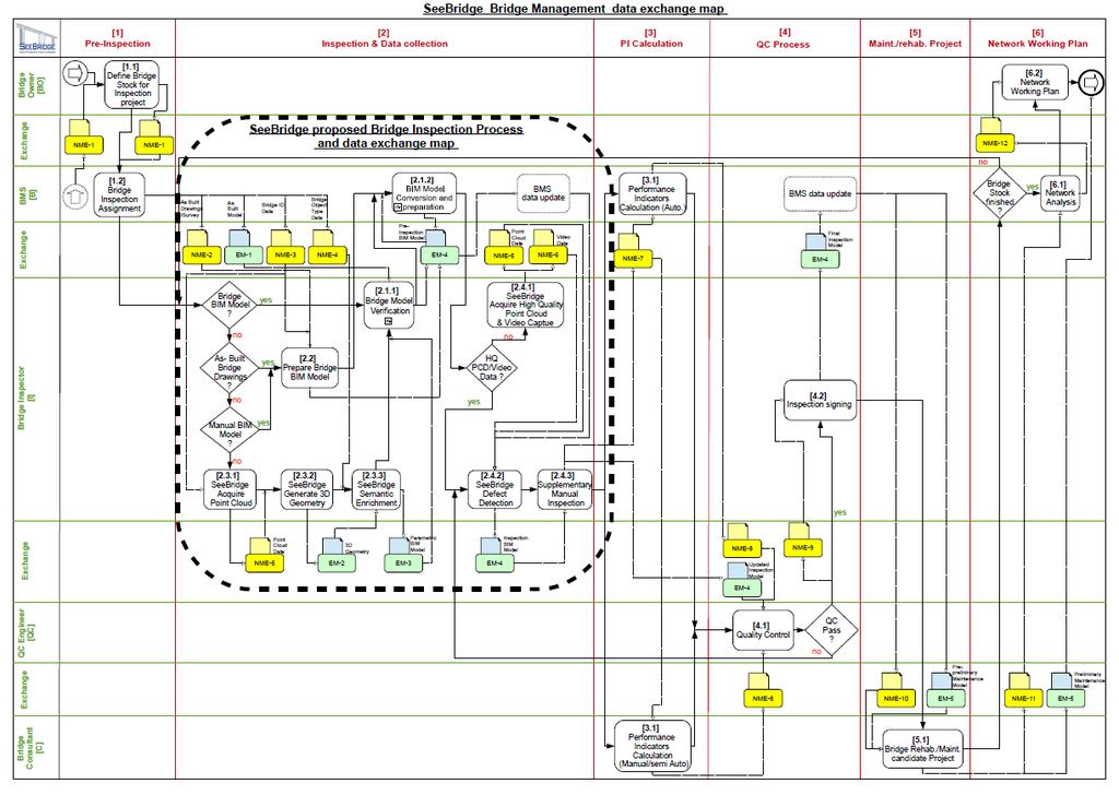
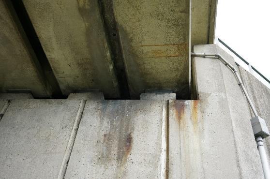
14 Overview Finally, SeeBridge identifies defects and maps them to bridge BIM model.


15 Overview Partners are:


16 Overview Supported by: London Underground AEC 3 Germany
17 Introduction Infravation is an ERA-NET Plus EU FP7 framework program a pooled research fund to develop transport infrastructure innovations aimed at cost-effective advanced systems, materials and techniques in road infrastructure construction and maintenance, including repair, retrofitting and revamping. The solutions called for include materials technology, methods and processes, and supporting systems, such as for monitoring, communication and energy.
18 Introduction SeeBridge is a proposed process for automatically compiling BIM models of existing concrete highway bridges that includes precise information about their components, geometry and surface defects
19 Overview SeeBridge consists of 5 major work packages: WP1: Information Delivery Manual WP2: Point Cloud Data Acquisition WP3: Point Cloud to Geometry Processing WP4: Semantic Enrichment WP5: Damage Detection and Identification
20 WP 1 Information delivery manual

21 WP1 WP2 WP3 WP4 WP5 Information Delivery Manual SeeBridge IDM Information Delivery Manual describes: the processes the data exchange scenarios the data requirements involved with data exchanges basis for Model View Definition (MVD)

22 WP1 WP2 WP3 WP4 WP5 Information Delivery Manual SeeBridge IDM Process Map Exchange Scearios Exchange Requeriments
23 Vision

24 Vision
25 Vision Exchange Requirements
26 WP1 WP2 WP3 WP4 WP5 Model View Definition SeeBridge MVD Subset of the IFC4 Schema Rules for structures, attributes and geometry SeeBridge items mapped to IFC entities SeeBridge Exchange Models mapped to IFC Model View Exchange Requirements On the basis of the IDM an mvdxml template was generated featuring relevant Concept Templates.

27 WP1 WP2 WP3 WP4 WP5 Model View Definition SeeBridge MVD Online database BIM*Q from AEC3 for mapping of the IDM onto IFC4 No extension of the IFC schema necessary Usage of predefined types and PropertySets The mvdxml is exported from BIM*Q

28 WP1 WP2 WP3 WP4 WP5 Model View Definition SeeBridge MVD IFC models must be generated according to the MVD The MVD is used to check IFC models for compliance Tool: XBIM Explorer Helps to ensure quality of delivered IFC files

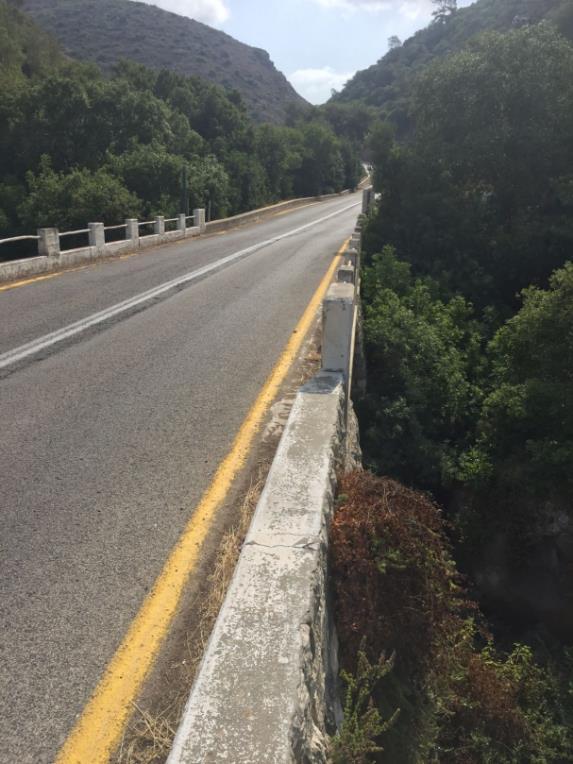
29 Vision SeeBridge MVD Modeling of defects as surface features (IfcSurfaceFeature) A defect can span several elements and is comprised of element defects Current IFC tools can correctly visualize modeled defects
30 WP 2 Point Cloud Data Acquisition


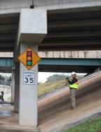
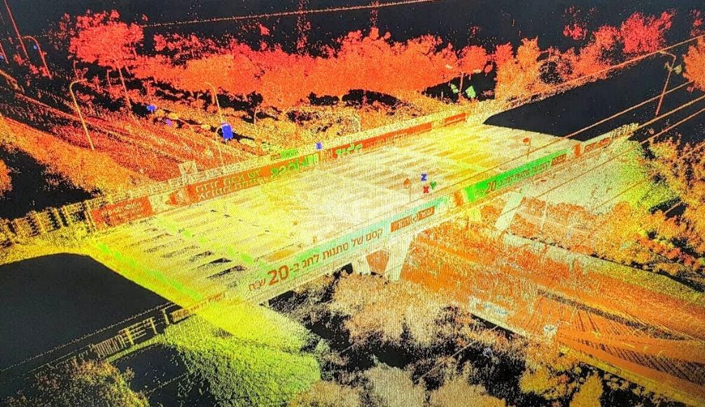
31 Data Acquisition 14 bridge datasets were collected: Leica Scanstation C-10 Cambridge, UK 10 Atlanta, USA 3 Haifa, Israel 1 Sony alpha 7R/II DSLR camera Sony mm F4 5.6 G SSM II zoom lens Trimble TX5 Faro Focus 3D X330 WP1 WP2 WP3 WP4 WP5


32 WP1 WP2 WP3 WP4 WP5 Data Acquisition On-site data collection:
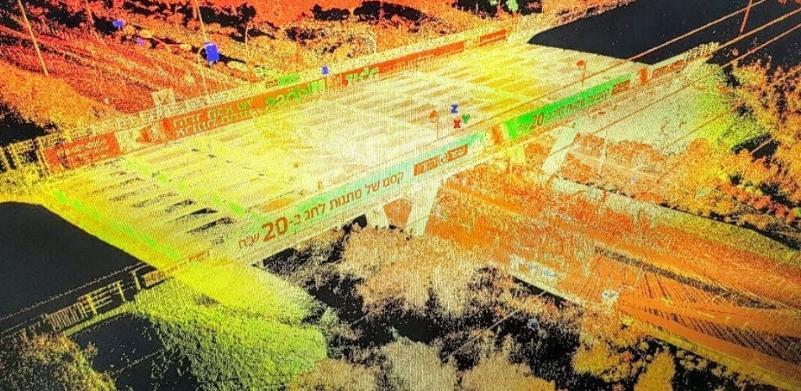
33 SEEBridge

34 Acworth Bridge Cambridge University

35 Gwinnett Bridge Cambridge University
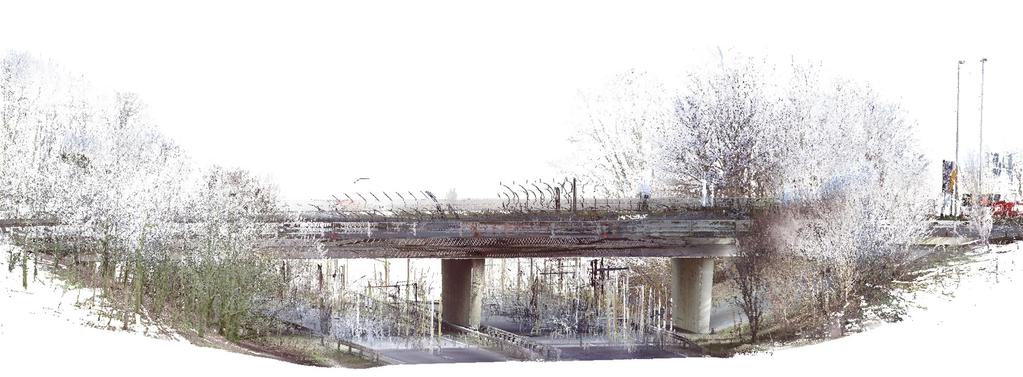
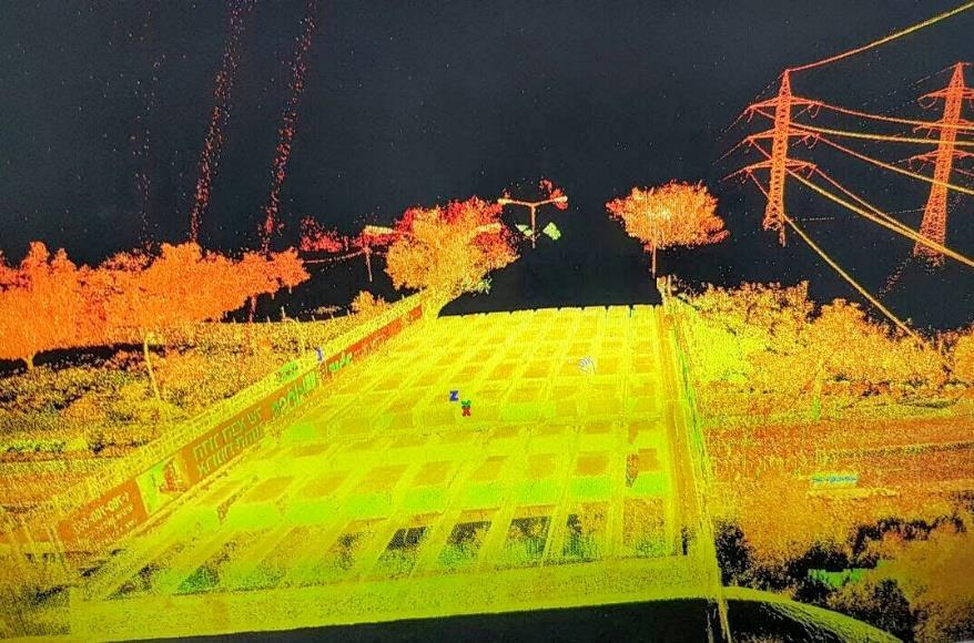
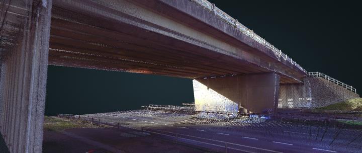
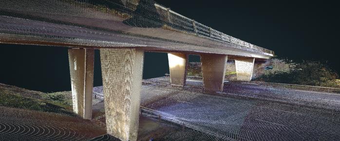
36 1A Terrestrial Data Collection: Results: What is possible Acworth, GA
37 1A Terrestrial Data Collection: Results: What is possible Gwinnett, GA


38 1A Terrestrial Data Collection: Results: What is possible Cambridge, UK #2 Cambridge, UK #8
39 41


40 WP1 WP2 WP3 WP4 WP5 Point Cloud Data Atlanta Haifa Cambridge


41 WP1 WP2 WP3 WP4 WP5 Image Data High Res Close-Ups
42 WP 3 Volume Geometry Generation
43 WP1 WP2 WP3 WP4 WP5 Detecting Objects Objective: To detect bridge objects at LOD 300 in bridge point cloud datasets To fit labelled, 3D solid components of the bridge structure. Deliverables:
44 WP1 WP2 WP3 WP4 WP5 Option 1: Bottom-up model (e.g. bridge) assemblies components surfaces points


45 WP1 WP2 WP3 WP4 WP5 Option 1: Bottom-up 1. Surface primitive and parametric model extraction 2. Detection and classification of bridge components from primitives 3. Bridge component parser for generating IFC model files. IFC Model Surface primitive estimation
46 WP1 WP2 WP3 WP4 WP5 Option 2: Top-down two major tasks Object detection in PCD Point clusters fitting Point cloud segmentation Point cluster classification


47 WP1 WP2 WP3 WP4 WP5 Option 2: Top-down Slicing algorithm


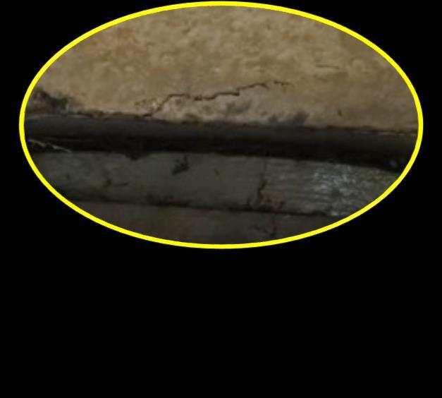
48 WP1 WP2 WP3 WP4 WP5 Option 2: Top-down Object detection in PCD Point clusters fitting merging
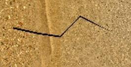
49 WP1 WP2 WP3 WP4 WP5 WP 4 Semantic Enrichment

50 WP1 WP2 WP3 WP4 WP5 Semantic Enrichment Objective: To build and test a software application capable of upgrading a 3D bridge model to an information model that is sufficiently rich to serve as a central component for Bridge Management Systems. Deliverables:
51 WP1 WP2 WP3 WP4 WP5 Semantic Enrichment The enrichment process Plain geometry model in IFC file Additional Info from BMS Numbering Classification Axes Reconstruction Aggregation Occlusion Enriched model of the bridge Semantic enrichment of building models refers to the automatic or semi-automatic addition of meaningful information to a digital model of a building or other structure by software that can deduce new information by processing rules or by applying machine-learning (Bloch et al. 2017)

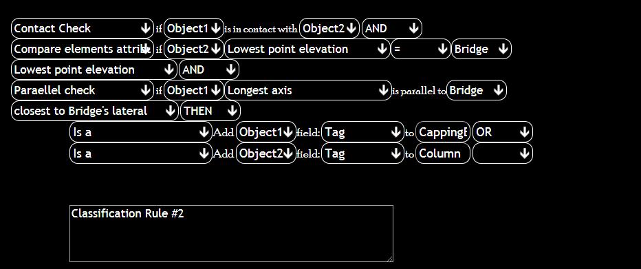
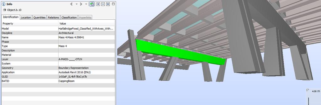
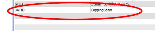
52 WP1 WP2 WP3 WP4 WP5 Classification: Identifying objects


53 Aggregation: grouping objects Types of groups Functional systems e.g. structure, lighting, safety, drainage etc. Mutually exclusive subsystems e.g. superstructure and substructure. Concept groups WP1 WP2 WP3 WP4 WP5 e.g. span between axes A and B


54 Reconstruction of axes Longitudinal and lateral axes Longitudinal curvature of multi-span bridges WP1 WP2 WP3 WP4 WP5


55 Occlusion: repairing geometry Lengthening the occluded beams Inserting placeholders for missing objects Recreating deck structure WP1 WP2 WP3 WP4 WP5
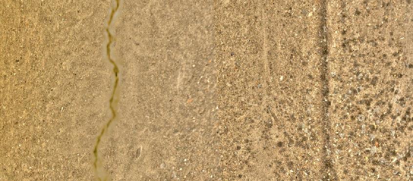
56 Girder lengthening algorithm to the capping beam no Should they be adjacent? yes Is the girder too short? yes Take one girder and one capping beam Find the minimal distance from edge of girder to axis of capping beam in XY projection Do nothing From the start From the start or the end? From the end Calculate the correct length and new start point Copy new beam to start point & set the correct length
57 Output model IFC and MVD compliance Post processor WP1 WP2 WP3 WP4 WP5
58 WP 5


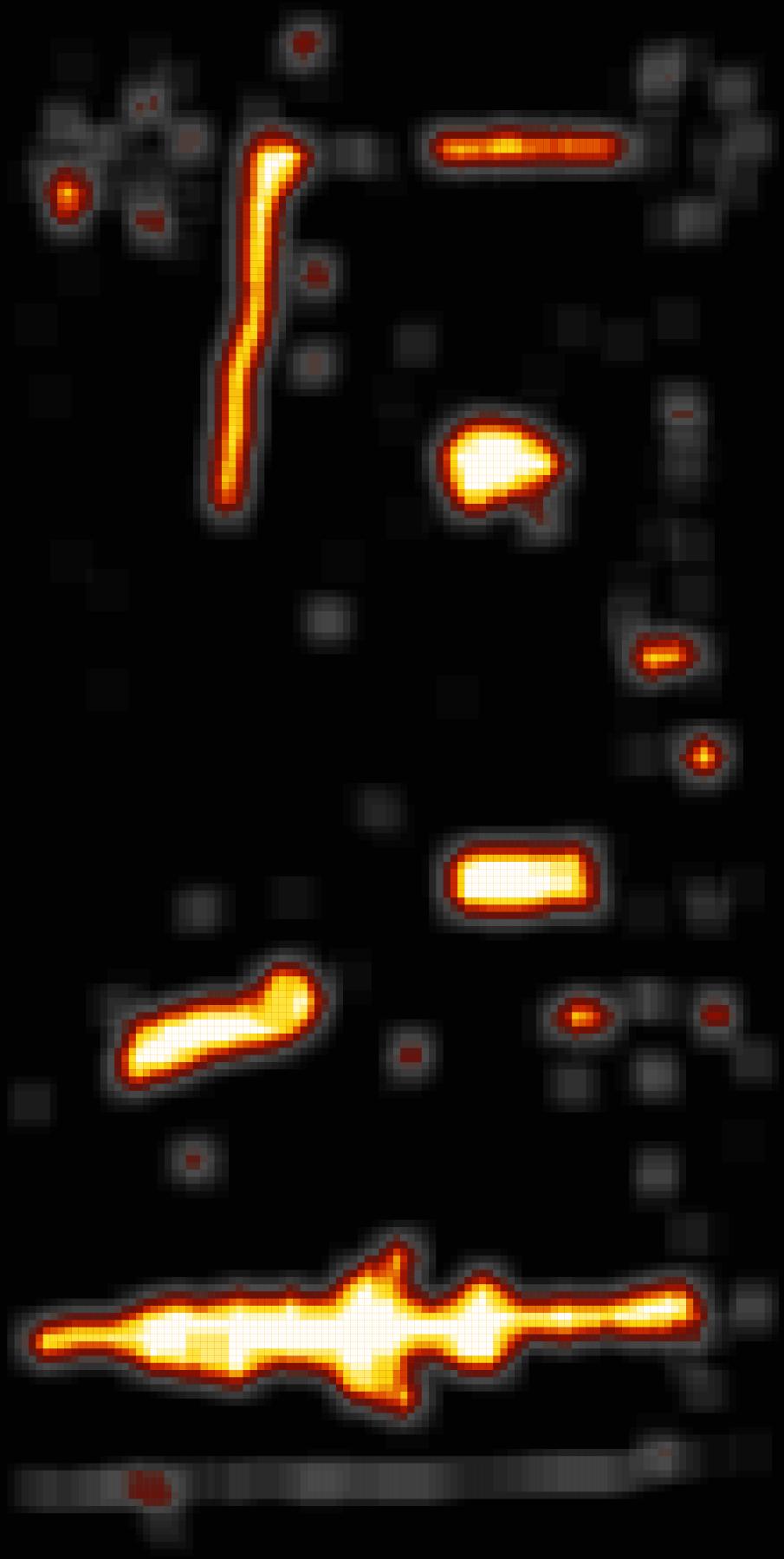
59 Texture Mapping and Defect Detection Goal: The goal of this step is to take a bridge geometry model and high resolution imagery of a bridge as input and generate bridge element surface texture and defect information as output. Crack IF C BIM Integration Texture Reconstruction Approach: Photogrammetry Inverted Ray Tracing Defect Detection Deep learning (CNN) Dataset DoT s + own collection Inspection Manual Analysis Build information model WP1 WP2 WP3 WP4 WP5

60
61
62


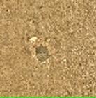
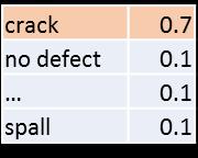
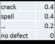
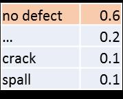
63 Defect Detection - Step 2

64 Integrating defect information into BIM models Add defects and build defect history over time
65 Results
66
 and Model View Definition (MVD) Point Cloud Data")
 Top-down (Cambridge) Semantic")


67 Technology readiness level (TRL) Information Delivery Manual (IDM) and Model View Definition (MVD) Point Cloud Data Acquisition Laser Scanning Photogrammetry 3D Geometry Reconstruction Bottom-up (GT) Top-down (Cambridge) Semantic Enrichment Damage Detection and Modeling Slab Bridges Now we are here TRL 6 TRL 7 TRL 6 TRL 6 TRL 6 TRL 8 TRL 6 TRL 7 Girder Bridges TRL 6 We started here TRL 6 TRL 6 Note: the data from 3D reconstruction, semantic enrichment, and damage detection must all be compliant with the SeeBridge MVD
68 Gaps in Technology What is missing? - Extensive testing - Rule sets for additional bridge types (only girder bridges and slab bridges dealt with) - Integration of models in Bridge Management Systems What further research is needed? - Better solutions for 3D reconstruction of girder bridges - Extensive testing to explore quantitatively how much user input is still required for BIM compilation
69 Technology Transfer What opportunities are there for commercialization? - Licensing of the procedure - Implementation - Stand-alone bridge inspection tool - Embedded in Bridge Management System software tools
70 Closing This project has received funding from the European Union s Seventh Framework Programme for research, technological development and demonstration under grant agreement no SeeBridge is co-funded by Funding Partners of the ERA-NET Plus Infravation and the European Commission. The Funding Partners of the Infravation 2014 Call are: Ministerie van Infrastructuur en Milieu, Rijkswaterstaat, Bundesministerium für Verkehr, Bau und Stadtentwicklung, Danish Road Directorate, Statens Vegvesen Vegdirektoratet, Trafikverket Trv, Vegagerðin, Ministere de L ecologie, du Developpement Durable et de L energie, Centro para el Desarrollo Tecnologico Industrial, Anas S.P.A., Netivei Israel National Transport Infrastructure Company Ltd, Federal Highway Administration USDOT
SeeBridge Demonstrator
 Automated Compilation of Semantically Rich BIM Models of Bridges Highway bridge Point Cloud Data 3D geometry BIM model BIM model with defects Non contact survey 3D Reconstruction Semantic Enrichment Damage
Deliverable 6.1. Project Scientific Report
 ERA-NET Plus on Infrastructure Innovation SeeBridge Semantic Enrichment Engine for Bridges Start date: 01/10/2015 Duration: 21 months Deliverable 6.1 Project Scientific Report Main Editor(s) Technion Rafael
Point Clouds to IFC/BrIM Objective:
 Point Clouds to IFC/BrIM Objective: Develop and demonstrate a point cloud data processing solution, which takes a point cloud of a bridge obtained from laser scanning as input, and generates a solid model
Project Description: Automated Compilation of Semantically Rich BIM Models of Bridges Information Delivery Manual
 BIM Guideline Detailed Exchange Requirements Project SeeBridge for the Project Phase Inspection & Data Collection Date: 23.03.2017 Creator: Burcu Esen Barutcu Project : Automated Compilation of Semantically
LIDAR BASED BRIDGE EVALUATION PH.D DEFENSE - WANQIU LIU. Advisor: Dr. Shen-en Chen
 LIDAR BASED BRIDGE EVALUATION PH.D DEFENSE - WANQIU LIU Advisor: Dr. Shen-en Chen Acknowledgement Dr. Edd Hauser Dr. Gary Teng Dr. Srinivas Pulugurtha Dr. Jing Zhou USDOT-RiTA Project No. DTOS59-07-H-0005
An Overview of BuildingSMART. Christopher Groome Secretary buildingsmart International Moscow June 2016
 An Overview of BuildingSMART Christopher Groome Secretary buildingsmart International Moscow June 2016 buildingsmart today Values Open Neutral Not-for-profit International Goals Create open BIM standards
DURAARK. Ex Libris conference April th, 2013 Berlin. Long-term Preservation of 3D Architectural Data
 DURAARK Long-term Preservation of 3D Architectural Data Ex Libris conference April 29-30 th, 2013 Berlin Dr Helmi Ben Hmida (Leibniz University Hanover, DE) 1 / 33 30 / 04 / 13 Dr Helmi Ben Hmida (Leibniz
2/19/2018. Who are we? Who am I? What is Scanning? How does scanning work? How does scanning work? Scanning for Today s Surveyors
 2/19/2018 Who are we? Scanning for Today s Surveyors Survey, GIS, and Construction dealer Founded in 1988 Employee Owned Headquartered in Bismarck, ND States covered: ND, SD, MN, MT, WY, CO, UT, ID, WA,
ERROR SOURCES IN PROCCESSING LIDAR BASED BRIDGE INSPECTION
 The International Archives of the Photogrammetry, Remote Sensing and Spatial Information Sciences, XLII-/W7, 07 ISPRS Geospatial Week 07, 8 September 07, Wuhan, China ERROR SOURCES IN PROCCESSING LIDAR
Toward generation of a Building Information Model of a deformed structure using laser scanning technology
 Toward generation of a Building Information Model of a deformed structure using laser scanning technology R Zeibak-Shini, R Sacks & S Filin Technion Israel Institute of Technology, Israel Earthquakes are
Building Information Modeling (BIM) and Measuring Techniques
 and Measuring Techniques") Building Information Modeling (BIM) and Measuring Techniques Christian CLEMEN, Robert EHRICH and Christopher VAN ZYL, Germany C. Clemen, R. Ehrich,C. van Zyl Building Information Model (BIM) and Measuring
Building Information Modeling (BIM) and Measuring Techniques Christian CLEMEN, Robert EHRICH and Christopher VAN ZYL, Germany C. Clemen, R. Ehrich,C. van Zyl Building Information Model (BIM) and Measuring
OPTIMIZING 3D SURFACE CHARACTERISTICS DATA COLLECTION BY RE-USING THE DATA FOR PROJECT LEVEL ROAD DESIGN
 OPTIMIZING 3D SURFACE CHARACTERISTICS DATA COLLECTION BY RE-USING THE DATA FOR PROJECT LEVEL ROAD DESIGN Benoit Petitclerc, P.E. John Laurent, M. Sc Richard Habel, M. Sc., Pavemetrics Systems Inc., Canada
Product Libraries in Ifc format. Open access to product information throughout a buildings lifecycle
 Product Libraries in Ifc format Open access to product information throughout a buildings lifecycle Prepared by Bjørn K Stangeland for the buiildingsmart conference in Tokyo, October 2012 Requirements
Trimble MX2 mobile mapping
 Trimble MX2 mobile mapping user applications Point clouds within your reach The Trimble MX2 is a vehicle-mounted spatial imaging system which combines high resolution laser scanning and panoramic cameras
Welcome to Singapore. Richard Petrie CEO buildingsmart International 12 th October 2015
 Welcome to Singapore Richard Petrie CEO buildingsmart International 12 th October 2015 Framing the last two years Establishing the Strategy & Business Organisation Our Strategy The Goal Enable full benefits
Innovation. lidarnews.com. volume 3 issue 5. Points clouds and terrain models support rail project. Structured light scanning for human head modeling
 volume 3 issue 5 LIDAR lidarnews.com SCALABILITY Points clouds and terrain models support rail project EXPRESSION Structured light scanning for human head modeling FLUCTUATION Scanning moving objects using
Technical Report Model Exchange between Revit and Allplan using IFC: a Case Study for a Bridge Model
 Technische Universität München Department of Civil, Geo and Environmental Engineering Chair of Computational Modeling and Simulation Technical Report Model Exchange between Revit and Allplan using IFC:
M. JOUBERT JA JOUBERT ARCHITECTURE R. THOMAS NORTH BY NORTHWEST W. KLEIN SIEMENS C. VAN ZWEEP - UNIRESEARCH COORDINATOR ANS VAN DOORMAAL (TNO)
") DELIVERABLE REPORT DELIVERABLE N 0 : D2.7 DISSEMINATION LEVEL: PUBLIC Title: DEMONSTRATOR OF THE ELASSTIC DESIGN DATE: 22 APRIL 2016 VERSION: FINAL AUTHOR(S): M. JOUBERT JA JOUBERT ARCHITECTURE REVIEWED
DELIVERABLE REPORT DELIVERABLE N 0 : D2.7 DISSEMINATION LEVEL: PUBLIC Title: DEMONSTRATOR OF THE ELASSTIC DESIGN DATE: 22 APRIL 2016 VERSION: FINAL AUTHOR(S): M. JOUBERT JA JOUBERT ARCHITECTURE REVIEWED
INTERLINK A EUROPEAN ROAD OTL. LDAC 5 th Linked Data in Architecture and Construction Workshop November 2017 Dijon, France
 INTERLINK A EUROPEAN ROAD OTL LDAC 5 th Linked Data in Architecture and Construction Workshop Dijon, France INTERLINK http://www.cedr.eu/strategic-plan-tasks/research/cedr-call-2015/call- 2015-asset-information-using-bim/interlink/
JBIM. The BIM Balancing Act: Tilt the Scales. in Your Favor
 JBIM Fall 2008 Journal of Building Information Modeling An official publication of the National BIM Standard (NBIMS) and the National Institute of Building Sciences (NIBS) The BIM Balancing Act: Tilt the
PGSuper Tutorials. Modeling Inverted Tee Bent Caps
 PGSuper Tutorials from PGSuper.com Modeling Inverted Tee Bent Caps BridgeSight Inc. P.O. Box 19172 1848 Venice Drive South Lake Tahoe, CA 96151 877-0441-0346 www.bridgesight.com Title PGSuper Tutorial
Web-based Database System for Bridge Management Systems
 Web-based Database System for Bridge Management Systems Ayaho MIYAMOTO Prof., Dr. Eng. Yamaguchi University Ube, Japan Ayaho Miyamoto, born 1949, received his Dr. of Eng. degree from Kyoto University in
Multi-models: New potentials for the combined use of planning and controlling information
 M.Sc. Sven-Eric Schapke, Institut für Bauinformatik, Technische Universität Dresden Dr.-Ing. Christoph Pflug, Max Bögl Multi-models: New potentials for the combined use of planning and controlling information
FHWA Bridge Information Modeling Update
 FHWA Bridge Information Modeling Update Presented by: Mike Bartholomew, P.E. / CH2M HILL for AASHTO Subcommittee on Bridges & Structures T-19 Technical Committee for Software & Technology Saratoga Springs,
Marc De Bruyne 3D Design Improvement Leader, DOW Chemical
 Marc De Bruyne 3D Design Improvement Leader, DOW Chemical John Foster Director, Profox Companies DOW Chemical Terneuzen in the Netherlands Globally, second largest DOW site after Freeport US. Producing
Advanced Data Procurement From A Contractors Perspective
 Advanced Data Procurement From a Contractors Perspective Advanced Data Procurement From A Contractors Perspective Brian K. Smith & Travis Rauscher, PE 1 Session Summary Laser scanning and UAV data procurement
RoadBIM Seminar Tallinn. Ongoing Swedish InfraBIM Activities Väino Tarandi, KTH & buildingsmart Sweden
 RoadBIM Seminar 11.09.2013 Tallinn Ongoing Swedish InfraBIM Activities Väino Tarandi, KTH & buildingsmart Sweden Agenda The Swedish Transport Administration BIM implementation V-con BIM-examples Stockholm
Integration of Parametric Geometry into IFC-Bridge
 Integration of Parametric Geometry into IFC-Bridge Yang Ji 1, Jakob Beetz 2, Nicholas Nisbet 3, Peter Bonsma 4, Casimir Katz 5, André Borrmann 1 1 Computational Modelling and Simulation Group, Technische
BIM for infrastructure make easy with Laser Scanner. 17 October Beng Chieh Quah Head of Marketing Asia Pacific
 BIM for infrastructure make easy with Laser Scanner 17 October 2016 Beng Chieh Quah Head of Marketing Asia Pacific who is? founded in 1981 NASDAQ since 1997 Global technology company Offering a range of
Displayed with permission The American Surveyor April/May Copyright 2009 Cheves Media
 NASA s Environmental Simulation Chamber A at the Johnson Space Center in Houston will require upgrades to accommodate testing of components for the new space telescopes. Laser scanning with the FARO LS
Advanced Highway Maintenance and Construction Technology Research Center
 Advanced Highway Maintenance and Construction Technology Research Center Department of Mechanical and Aerospace Engineering University of California at Davis Creating Standards and Specifications for the
Framework for building information modelling (BIM) guidance
 guidance") TECHNICAL SPECIFICATION ISO/TS 12911 First edition 2012-09-01 Framework for building information modelling (BIM) guidance Cadre pour les directives de modélisation des données du bâtiment Reference number
TECHNICAL SPECIFICATION ISO/TS 12911 First edition 2012-09-01 Framework for building information modelling (BIM) guidance Cadre pour les directives de modélisation des données du bâtiment Reference number
Semi-Automatic Techniques for Generating BIM Façade Models of Historic Buildings
 Semi-Automatic Techniques for Generating BIM Façade Models of Historic Buildings C. Dore, M. Murphy School of Surveying & Construction Management Dublin Institute of Technology Bolton Street Campus, Dublin
MOBILE INSPECTION SYSTEM FOR HIGH-RESOLUTION ASSESSMENT OF TUNNELS
 MOBILE INSPECTION SYSTEM FOR HIGH-RESOLUTION ASSESSMENT OF TUNNELS M. Gavilán*, F. Sánchez, J.A. Ramos and O. Marcos EUROCONSULT GROUP Avenida Montes de Oca 9-11, 28703, Madrid, Spain *Corresponding author:
RD-Action WP5. Specification and implementation manual of the Master file for statistical reporting with Orphacodes
 RD-Action WP5 Specification and implementation manual of the Master file for statistical reporting with Orphacodes Second Part of Milestone 27: A beta master file version to be tested in some selected
Cloud-based Rapid Elastic MAnufacturing
 Cloud-based Rapid Elastic MAnufacturing WP9 Impact D9.2.1 Promotion and Promotional Material Deliverable Lead: TANet Contributing Partners: ASC Delivery 03/2015 Dissemination Level: Public Version 1.0
Reality Modeling Webinar
 Reality Modeling Webinar Leveraging 3D Reality Meshes for Real-Time Asset Management and Monitoring What is Reality Modeling? Images & video? What is Reality Modeling? Images & video As-built drawings
FRAMEWORK OF THE EXTENDED PROCESS TO PRODUCT MODELING (XPPM) FOR EFFICIENT IDM DEVELOPMENT
 FOR EFFICIENT IDM DEVELOPMENT") FRAMEWORK OF THE EXTENDED PROCESS TO PRODUCT MODELING (XPPM) FOR EFFICIENT IDM DEVELOPMENT Ghang Lee, Ph.D. Associate Professor, glee@yonsei.ac.kr Sungil Ham, Ph.D. / Postdoctoral Researcher, archispace@yonsei.ac.kr
FRAMEWORK OF THE EXTENDED PROCESS TO PRODUCT MODELING (XPPM) FOR EFFICIENT IDM DEVELOPMENT Ghang Lee, Ph.D. Associate Professor, glee@yonsei.ac.kr Sungil Ham, Ph.D. / Postdoctoral Researcher, archispace@yonsei.ac.kr
Multi-ray photogrammetry: A rich dataset for the extraction of roof geometry for 3D reconstruction
 Multi-ray photogrammetry: A rich dataset for the extraction of roof geometry for 3D reconstruction Andrew McClune, Pauline Miller, Jon Mills Newcastle University David Holland Ordnance Survey Background
Delivering Infrastructure with Certainty: DfMA Case Studies 11/07/2018
 Delivering Infrastructure with Certainty: DfMA Case Studies 11/07/2018 Delivering Infrastructure with Certainty Where we work 2 Delivering Infrastructure with Certainty Laing O Rourke Approach to Delivery
Measurements using three-dimensional product imaging
 ARCHIVES of FOUNDRY ENGINEERING Published quarterly as the organ of the Foundry Commission of the Polish Academy of Sciences ISSN (1897-3310) Volume 10 Special Issue 3/2010 41 46 7/3 Measurements using
Microwave. Infrared. Preprogrammed Chip
 Advanced Technology for Design Mapping and Construction Layout AACE A.A.C.E. Meeting August 5, 2009 Daniel K. Mardock RBF Consulting Survey Manager Registered Land Surveyor Certified Federal Surveyor Arizona
D5.2 FOODstars website WP5 Dissemination and networking
 D5.2 FOODstars website WP5 Dissemination and networking This project has received funding from the European Union s Horizon 2020 research and innovation programme under grant agreement No 692276. DISCLAIMER
standard Introduction November 2015
 The COINS standard Introduction November 2015 Agenda Summary Why COINS What is COINS Scope COINS container exchange format Integration examples Integration GIS Integration documents Integration IFC and
Realworks Software. A Powerful 3D Laser Scanning Office Software Suite
 TECHNICAL NOTES Realworks Software A Powerful 3D Laser Scanning Office Software Suite Trimble RealWorks is a powerful office software that imports rich data from your 3D laser scanning instrument and transforms
FRAMEWORK OF THE EXTENDED PROCESS TO PRODUCT MODELING (XPPM) FOR EFFICIENT IDM DEVELOPMENT
 FOR EFFICIENT IDM DEVELOPMENT") FRAMEWORK OF THE EXTENDED PROCESS TO PRODUCT MODELING (XPPM) FOR EFFICIENT IDM DEVELOPMENT Ghang Lee, Ph.D. Associate Professor, glee@yonsei.ac.kr, Corresponding Author Sungil Ham, Ph.D. / Postdoctoral
FRAMEWORK OF THE EXTENDED PROCESS TO PRODUCT MODELING (XPPM) FOR EFFICIENT IDM DEVELOPMENT Ghang Lee, Ph.D. Associate Professor, glee@yonsei.ac.kr, Corresponding Author Sungil Ham, Ph.D. / Postdoctoral
2/9/2016. Session Agenda: Implementing new Geospatial Technologies for more efficient data capture
 Implementing new Geospatial Technologies for more efficient data capture Jay Haskamp Applied Geospatial Engineer Steve Richter VP Sales Session Agenda: Today s changing technologies and what lies ahead
METADATA MANAGEMENT AND STATISTICAL BUSINESS PROCESS AT STATISTICS ESTONIA
 Distr. GENERAL 06 May 2013 WP.13 ENGLISH ONLY UNITED NATIONS ECONOMIC COMMISSION FOR EUROPE CONFERENCE OF EUROPEAN STATISTICIANS EUROPEAN COMMISSION STATISTICAL OFFICE OF THE EUROPEAN UNION (EUROSTAT)
Questions and Answers for Customers
 Autodesk InfraWorks 360 Questions and Answers for Customers www.sistemacad.com General Information 2 1.1 Are any changes being made to how Autodesk InfraWorks is packaged in 2015? 2 1.2 I have been using
Storage Tank Solutions TRANSFORMING THE WAY THE WORLD WORKS
 Storage Tank Solutions Trimble TX8 Scanner: A Revolution in 3D Scanning TRUE PERFORMANCE IN A REAL WORLD The Trimble TX8 laser scanner sets new standards for performance and ease of use in high-speed collection
DEPARTMENT OF CIVIL AND ENVIRONMENTAL ENGINEERING REPORTS
 DEPARTMENT OF CIVIL AND ENVIRONMENTAL ENGINEERING REPORTS Laser-Based Structural Sensing and Surface Damage Detection September 2014 Burcu Guldur Northeastern University Jerome F. Hajjar Northeastern University
Horizon 2020 INFRADEV Design studies. RICHFIELDS Working Packages 2 Deliverable D2.2. Project identity. Date delivered: M6
 Horizon 2020 INFRADEV-1-2014 - Design studies RICHFIELDS Working Packages 2 Deliverable D2.2 Project identity Date delivered: M6 Author: Christina Sadler Deliverable lead beneficiaries: EUFIC Project Project
ADVANCING REALITY MODELING WITH CONTEXTCAPTURE
 ADVANCING REALITY MODELING WITH CONTEXTCAPTURE Knowing the existing conditions of a project is a key asset in any decision process. Governments need to better know their territories, through mapping operations,
Robot-based real-time ultrasonic tomography for industrial NDT applications
 1 Robot-based real-time ultrasonic tomography for industrial NDT applications Dr. Andrey Bulavinov I-Deal Technologies GmbH 2 Content I. Introduction of I-Deal Technologies GmbH I-Deal Spin-Off of Fraunhofer-IZFP
Deliverable D8.5 Video Showcase
 DOCUMENT Deliverable Number D8.5 Due Date 31/05/2016 Issued by WP/Task WP8/T8.5 Actual Date 18/07/2016 Dissemination Level PUBLIC Pages 17 Appendices one PROJECT Grant Agreement No. 606645 Acronym RPB
Innovative Technology for Computer Automated Bridge Inspection Process
 TRANSPORTATION RESEARCH RECORD 1347 Innovative Technology for Computer Automated Bridge Inspection Process S. S. Kuo, THOMAS E. DAVIDSON, LEONARD M. FIJI, AND RICHARD KERR A procedure is presented for
3D Optics (including Photogrammetry)
") To: USDOT/RITA research team members From: C. Brooks, D. Evans CC: P. Hannon Date: October 15 th, 2010 Number: 07 Re: Work plans progress to date The following summarizes the work plans associated with
To: USDOT/RITA research team members From: C. Brooks, D. Evans CC: P. Hannon Date: October 15 th, 2010 Number: 07 Re: Work plans progress to date The following summarizes the work plans associated with
2011 Bentley Systems, Incorporated. Bentley Descartes V8i Advancing Information Modeling For Intelligent Infrastructure
 Bentley Descartes V8i Advancing Information Modeling For Intelligent Infrastructure Agenda Why would you need Bentley Descartes? What is Bentley Descartes? Advanced Point Cloud Workflows Advanced Terrain
EU Liaison Update. General Assembly. Matthew Scott & Edit Herczog. Reference : GA(18)021. Trondheim. 14 June 2018
021. Trondheim. 14 June 2018") EU Liaison Update General Assembly Matthew Scott & Edit Herczog Reference : GA(18)021 Trondheim 14 June 2018 Agenda Introduction Outcomes of meetings with DG CNECT & RTD, & other stakeholders Latest FP9
EU Liaison Update General Assembly Matthew Scott & Edit Herczog Reference : GA(18)021 Trondheim 14 June 2018 Agenda Introduction Outcomes of meetings with DG CNECT & RTD, & other stakeholders Latest FP9
HORIZON2020 FRAMEWORK PROGRAMME TOPIC EUK Federated Cloud resource brokerage for mobile cloud services. D7.1 Initial publication package
 HORIZON2020 FRAMEWORK PROGRAMME TOPIC EUK-03-2016 Federated Cloud resource brokerage for mobile cloud services D7.1 Initial publication package Project acronym: BASMATI Project full title: Cloud Brokerage
implementation of the proposed approach, including a Client Server (C/S) platform and the workflow of integration application. Finally, we demonstrate
 platform and the workflow of integration application. Finally, we demonstrate") Towards BIM-based model integration and safety analysis for bridge construction Zhang Xiaoyang 1 Lin Jiarui 2 Hu Zhenzhong 3 Zhang Jianping 4 Fang Ji 5 Du Shenyun 6 1) Master., Department of Civil Engineering,
Towards BIM-based model integration and safety analysis for bridge construction Zhang Xiaoyang 1 Lin Jiarui 2 Hu Zhenzhong 3 Zhang Jianping 4 Fang Ji 5 Du Shenyun 6 1) Master., Department of Civil Engineering,
Unwrapping of Urban Surface Models
 Unwrapping of Urban Surface Models Generation of virtual city models using laser altimetry and 2D GIS Abstract In this paper we present an approach for the geometric reconstruction of urban areas. It is
PROJECT DELIVERABLE REPORT
 PROJECT DELIVERABLE REPORT Grant Agreement Number: 283284 Project Acronym: X-Scan Project Title: Laser guided inspection robot for the Non-Destructive Testing of thin steel gauge welds in the shipping
RAIL HIGHWAY GRADE CROSSING ROUGHNESS QUANTITATIVE MEASUREMENT USING 3D TECHNOLOGY
 RAIL HIGHWAY GRADE CROSSING ROUGHNESS QUANTITATIVE MEASUREMENT USING 3D TECHNOLOGY Teng (Alex) Wang, Reginald Souleyrette& Jerry Rose University of Kentucky Lexington, KY Introduction Background: - highway-rail
INNOVER-EAST. WP5 Dissemination. Deliverable D5.3 Basic Dissemination Material
 INNOVER-EAST Building a more effective pathway leading from research to innovation through cooperation between the European Union and Eastern Partnership countries in the field of energy efficiency FP7
High Resolution Tree Models: Modeling of a Forest Stand Based on Terrestrial Laser Scanning and Triangulating Scanner Data
 ELMF 2013, 11-13 November 2013 Amsterdam, The Netherlands High Resolution Tree Models: Modeling of a Forest Stand Based on Terrestrial Laser Scanning and Triangulating Scanner Data Lothar Eysn Lothar.Eysn@geo.tuwien.ac.at
New Technologies for Pavement Evaluation
 New Technologies for Pavement Evaluation TxDOT 3-D Pavement Survey Technology For 86 th Annual Transportation Short Course at Texas A&M University, 2012 Dr. Yaxiong (Robin) Huang, Robin.Huang@txdot.gov
Simplicity is the new black: The BLK360 story
 Simplicity is the new black: The BLK360 story Vanda KADLECIKOVA Leica Geosystems Heerbrugg, Switzerland E-mail: vanda.kadlecikova@leica-geosystems.com Abstract Meet the game changer. The new Leica BLK360
High Definition Modeling of Calw, Badstrasse and its Google Earth Integration
 Master Thesis Yuanting LI High Definition Modeling of Calw, Badstrasse and its Google Earth Integration Duration of the Thesis: 6 months Completion: July, 2014 Supervisors: Prof.Dr.-Ing.Dieter Fritsch
VIRTUALIZATION PERFORMANCE: VMWARE VSPHERE 5 VS. RED HAT ENTERPRISE VIRTUALIZATION 3
 VIRTUALIZATION PERFORMANCE: VMWARE VSPHERE 5 VS. RED HAT ENTERPRISE VIRTUALIZATION 3 When you invest in a virtualization platform, you can maximize the performance of your applications and the overall
CAMERA CONSTANT IN THE CASE OF TWO MEDIA PHOTOGRAMMETRY
 CAMERA CONSTANT IN THE CASE OF TWO MEDIA PHOTOGRAMMETRY Panagiotis Agrafiotis and Andreas Georgopoulos Laboratory Of Photogrammetry, School of Rural and Surveying Engineering National Technical University
Cities, Infrastructure & Industrial Solutions
 Cities, Infrastructure & Industrial Solutions Singapore - Solving Tomorrow s Engineering Problems At a Glance The growth of Asian and Middle East economies has resulted in market demand for energy, refined
TM#17 page 1. Transportation Institute
 To: T. Ahlborn, D. Harris, L. Sutter, B. Shuchman, J. Burns From: K.A. Endsley, M. Forster, C. Brooks CC: D. Evans, R. Oats, K. Vaghefi, R. Hoensheid, de Melo e Silva Date: March 30, 2011 Number: 17 Re:
Deliverable D2.8. Paving the Way for Future Emerging DNA-based Technologies: Computer-Aided Design and Manufacturing of DNA libraries
 Funding Scheme: THEME [ICT-2007.8.0] [FET Open] Paving the Way for Future Emerging DNA-based Technologies: Computer-Aided Design and Manufacturing of DNA libraries Grant Agreement number: 265505 Project
Steel Structures Tutorial
 AASHTOWare BrD/BrR 6.8 Steel Structures Tutorial STL8 Pin and Hanger Rolled Beam Example Topics Covered Steel rolled beam with cover plates input as girder system. Schedule based input. Pin and hanger
Bringing Singapore to life in 3D
 Bringing Singapore to life in 3D Dr Victor Khoo, Deputy Director Singapore Land Authority Bringing Singapore to life in 3D ESRI Singapore UC 2016 Dr. Victor Khoo Singapore Land Authority SLA 2016 RESTRICTED
H2020 Space Robotic SRC- OG4
 H2020 Space Robotic SRC- OG4 2 nd PERASPERA workshop Presentation by Sabrina Andiappane Thales Alenia Space France This project has received funding from the European Union s Horizon 2020 research and
Indoor. Heritage Preservation CAD versus Cloud. inside. Applanix and CSIRO. Grows with LiDAR. Vol. 2 Issue 4 ABOVE & BEYOND. ipad & Tablet Ready!
 inside Indoor Mapping Applanix and CSIRO SMALL BUSINESS Grows with LiDAR Heritage Preservation CAD versus Cloud Vol. 2 Issue 4 ABOVE & BEYOND ipad & Tablet Ready! RE-MODELING THE MIXMASTER From Mobile
Laser Scanning. 3D Model is not existing and is required for: studies revamping maintenance HSE integration in another 3D model archiving
 Laser Scanning Laser Scanning Laser scanning is used whenever: 3D Model is not existing and is required for: studies revamping maintenance HSE integration in another 3D model archiving 2 Object acquisition
RealWorks Software. A Powerful 3D Laser Scanning Office Software Suite
 TECHNICAL NOTES RealWorks Software A Powerful 3D Laser Scanning Office Software Suite Trimble RealWorks is a powerful office software that imports rich data from your 3D laser scanning instrument and transforms
FAST REGISTRATION OF TERRESTRIAL LIDAR POINT CLOUD AND SEQUENCE IMAGES
 FAST REGISTRATION OF TERRESTRIAL LIDAR POINT CLOUD AND SEQUENCE IMAGES Jie Shao a, Wuming Zhang a, Yaqiao Zhu b, Aojie Shen a a State Key Laboratory of Remote Sensing Science, Institute of Remote Sensing
Flexible Visual Inspection. IAS-13 Industrial Forum Horizon 2020 Dr. Eng. Stefano Tonello - CEO
 Flexible Visual Inspection IAS-13 Industrial Forum Horizon 2020 Dr. Eng. Stefano Tonello - CEO IT+Robotics Spin-off of University of Padua founded in 2005 Strong relationship with IAS-LAB (Intelligent
Robust Automatic 3D Point Cloud Registration and Object Detection
 FEATURE EXTRACTION FOR BIM Robust Automatic 3D Point Cloud Registration and Object Detection BY DAVID SELVIAH This article presents a ground-breaking approach to generating survey data for a BIM process
LEHMANN + PARTNER GmbH. Automatic detection of defects based on machine learning algorithm Dr.-Ing. Dirk Ebersbach Prof. Dr.-Ing.
 LEHMANN + PARTNER GmbH Automatic detection of defects based on machine learning algorithm Dr.-Ing. Dirk Ebersbach Prof. Dr.-Ing. Andreas Großmann What does ASINVOS mean?: Assistive and interactive machine
Automated Visualization Support for Linked Research Data
 Automated Visualization Support for Linked Research Data Belgin Mutlu 1, Patrick Hoefler 1, Vedran Sabol 1, Gerwald Tschinkel 1, and Michael Granitzer 2 1 Know-Center, Graz, Austria 2 University of Passau,
Digital Preservation of the Aurelius Church and the Hirsau Museum Complex by Means of HDS and Photogrammetric Texture Mapping
 Master Thesis Ruxandra MOROSAN Ruxandra MOROSAN Digital Preservation of the Aurelius Church and the Hirsau Museum Complex by Means of HDS and Photogrammetric Texture Mapping Duration of the Thesis: 6 months
ROAD-SCANNER COMPACT APPLICATION FIELDS MAIN FEATURES
 ROAD-SCANNER COMPACT Mobile Mapping System by GEXCEL & SITECO collaboration A smaller mobile system for asset management and cartography suited for ZOLLER & FRÖHLICH PROFILER 9012 laser scanner. 2 + 3
Presented at the FIG Congress 2018, May 6-11, 2018 in Istanbul, Turkey
 Presented at the FIG Congress 2018, May 6-11, 2018 in Istanbul, Turkey Evangelos MALTEZOS, Charalabos IOANNIDIS, Anastasios DOULAMIS and Nikolaos DOULAMIS Laboratory of Photogrammetry, School of Rural
Integrated Projects. Madonna di Pietranico Pompeii insula V1 V I S UA L COMPUTING L A B I ST I - C N R
 Integrated Projects Madonna di Pietranico Pompeii insula V1 V I S UA L COMPUTING L A B I ST I - C N R La Madonna di Pietranico Pietranico s Madonna Terracotta statue, destroyed by an earthquake. We used
Two interrelated objectives of the ARIADNE project, are the. Training for Innovation: Data and Multimedia Visualization
 Training for Innovation: Data and Multimedia Visualization Matteo Dellepiane and Roberto Scopigno CNR-ISTI Two interrelated objectives of the ARIADNE project, are the design of new services (or the integration
ROAD SURFACE STRUCTURE MONITORING AND ANALYSIS USING HIGH PRECISION GPS MOBILE MEASUREMENT SYSTEMS (MMS)
") ROAD SURFACE STRUCTURE MONITORING AND ANALYSIS USING HIGH PRECISION GPS MOBILE MEASUREMENT SYSTEMS (MMS) Bonifacio R. Prieto PASCO Philippines Corporation, Pasig City, 1605, Philippines Email: bonifacio_prieto@pascoph.com
ROAD SURFACE STRUCTURE MONITORING AND ANALYSIS USING HIGH PRECISION GPS MOBILE MEASUREMENT SYSTEMS (MMS) Bonifacio R. Prieto PASCO Philippines Corporation, Pasig City, 1605, Philippines Email: bonifacio_prieto@pascoph.com
Terrestrial 3D laser scanning Practical aspects
 Terrestrial 3D laser scanning Practical aspects ISPRS WG VI/5&SC Summer School 2007 by Gregor Bilban 3D laser scanning Benefits Lower data collection costs Reduction or elimination of re-visits More accurate
Celebrity Identification and Recognition in Videos. An application of semi-supervised learning and multiclass classification
 Celebrity Identification and Recognition in Videos An application of semi-supervised learning and multiclass classification Contents Celebrity Identification and Recognition in Videos... 1 Aim... 3 Motivation...
Example of Monitoring Requirement
 CEGE Department 3DIMPact of Civil, Environmental & Geomatic Engineering (CEGE) 3D Imaging, Metrology, Photogrammetry Applied Coordinate Technologies (3DIMPact) Optical non-contact railway track measurement
Control System International a.s., Papírenská 114/5, Praha 6, Czech Republic Web site: www. controlsystem.cz,
 129 Consequences of a complex using of 3D approach in the implementation of the road reconstruction - usage of TLS stop&go and usage of paving control system for milling machines Přikryl, M. and Kutil,
3D Shape Analysis with Multi-view Convolutional Networks. Evangelos Kalogerakis
 3D Shape Analysis with Multi-view Convolutional Networks Evangelos Kalogerakis 3D model repositories [3D Warehouse - video] 3D geometry acquisition [KinectFusion - video] 3D shapes come in various flavors
Bentley OpenBridge Workshop 2017 FLUG Spring Training Event
 Bentley OpenBridge Workshop 2017 FLUG Spring Training Event 435 - Using Open Bridge Modeler and Lumenr RT Bentley Systems, Incorporated 685 Stockton Drive Exton, PA 19341 www.bentley.com Practice Workbook
Simplified vs Detailed Bridge Models: A Time and Costs Decision
 Fourth LACCEI International Latin American and Caribbean Conference for Engineering and Technology (LACCET 26) Breaking Frontiers and Barriers in Engineering: Education, Research and Practice 21-23 June
Empowering People with Knowledge the Next Frontier for Web Search. Wei-Ying Ma Assistant Managing Director Microsoft Research Asia
 Empowering People with Knowledge the Next Frontier for Web Search Wei-Ying Ma Assistant Managing Director Microsoft Research Asia Important Trends for Web Search Organizing all information Addressing user
REPORT 1A Analysis of needs and possibilities with the technology of the future
 REPORT 1A Analysis of needs and possibilities with the technology of the future Part of R&D project Infrastructure in 3D in cooperation between Innovation Norge, Trafikverket and TerraTec Trafikverket