Analytical and Computer Cartography Winter Lecture 14: Three Dimensional Mapping and Modeling
|
|
|
- Meredith Stokes
- 6 years ago
- Views:
Transcription

1 Analytical and Computer Cartography Winter 2017 Lecture 14: Three Dimensional Mapping and Modeling
2 3D measurement systems: remote sensing of objects First generation DEMs, photogrammetry and contour conversion Second generation based on SAR and IFSAR SRTM near global coverage, 30m/90m NED completed at 30m, then 15m and less LIDAR has now taking over New SfM photogrammetric methods showing promise


3 Photogrammetry

4 Interferometric Radar

5 IFSAR DEMs

6 SAR from Space


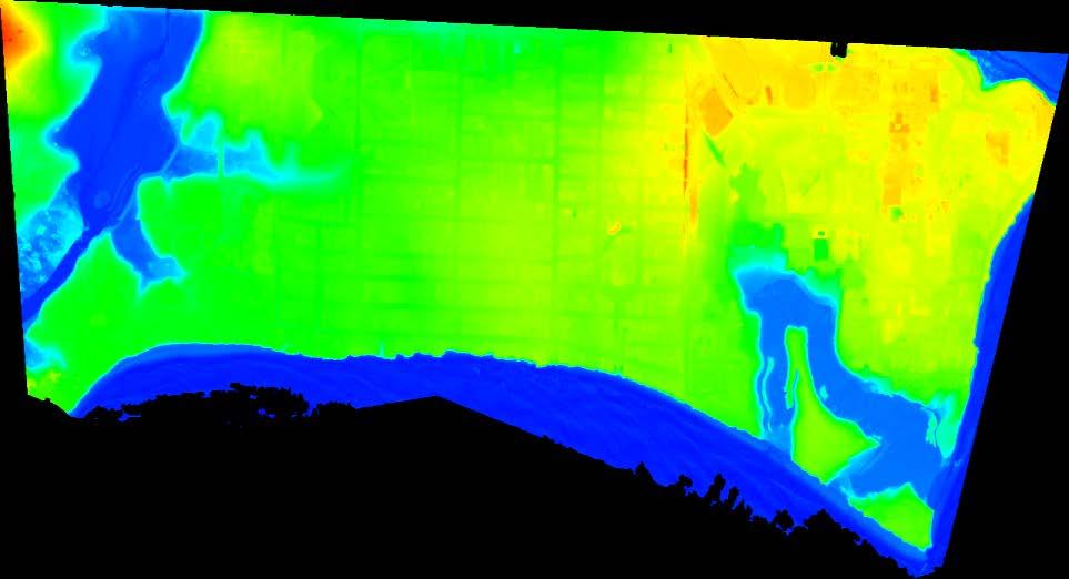
7 SRTM: Global topo map


8 How Lidar works


9 LIDAR first and last pulse

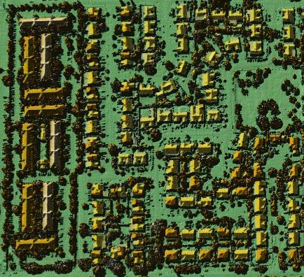
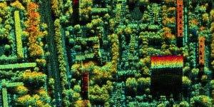
10 LIDAR terrain detail


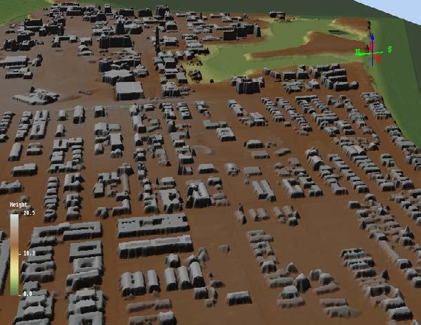
11 3D Models from LiDAR


12 LiDAR at El Pilar

13
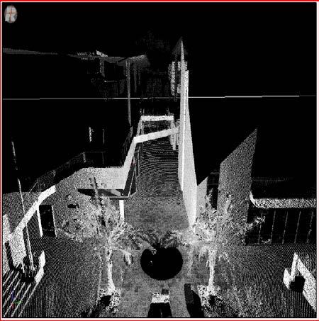

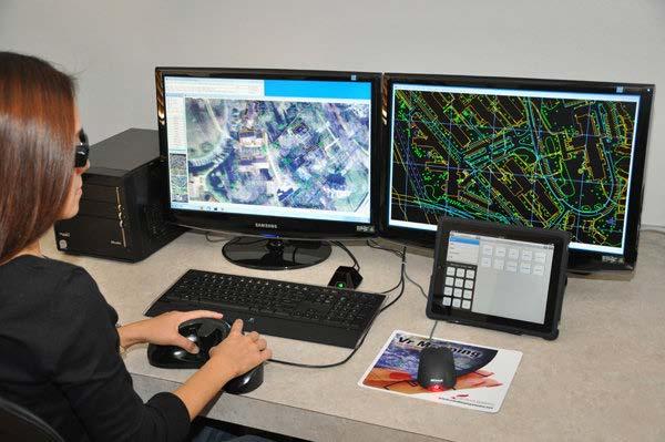
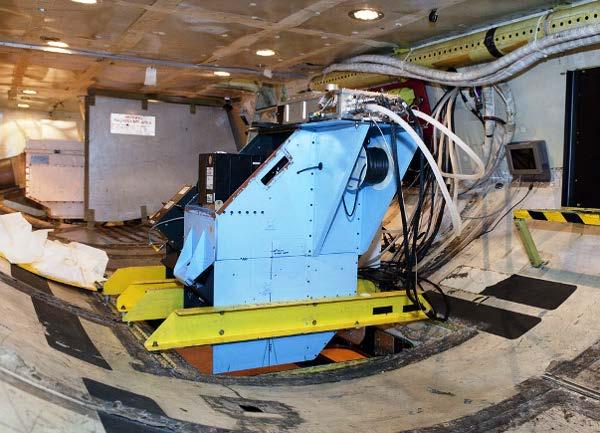
14 Terrestrial Scanning LiDAR

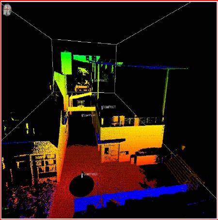
15 Campus scans

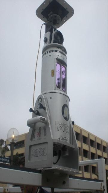
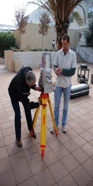
16 Riegl LMS-Z420i Laser Scanner


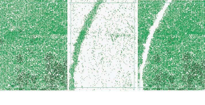
17 Lidar Point Cloud Data UCSB Ellison Hall, 1 st Floor Secondary Study Area EH Lobby Primary Study Area EH Room 1720 Additional Study Areas North Wing Hallway East Wing Hallway East Stairwell Data Collection Information Platform: Riegl LMS-Z420i Laser Scanner # Points: 35 million


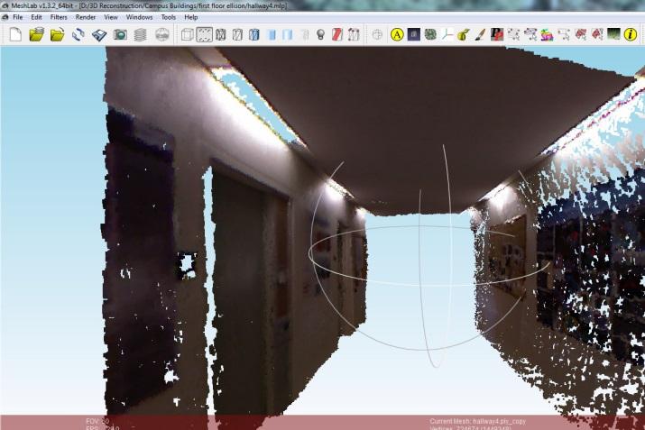
18 Lidar Point Cloud Data EH East Stairwell, 1 st /2 nd Floors
 Nikon D3100 (14.")


 Panasonic DMC-FZ28 (10.")
19 Platforms Tested To Date (EH Room 1720) Nikon D3100 (14.2 MP) Microsoft LifeCam Studio (2.1 MP) Logitech QuickCam Deluxe (0.3 MP) Sony DSC-TX10 (16.2 MP) Panasonic DMC-FZ28 (10.1 MP) Riegl LMS-Z420i Laser Scanner (Baseline Measurements)


20 Animated Point Cloud (LifeCam Studio)


21 Sample 3D Point Cloud via Webcam Camera: Microsoft LifeCam Studio (1920x1080) # Stations: 48 around room perimeter # Images: 144 HDR images # Points: 18.3 million
22 3D modeling and data structures Longley et. al. 6 models: gridded points, irregular points, cells, irregular polygons, TIN and contours Prior dominance of DEM Extensive use of TIN and surface patches Computer graphics and games favor Voxels LIDAR and photogrammetry return a POINT CLOUD Has led to use of term Digital Surface Model

23 Measurement vs. Modeling Select key surface points, edges Generalize remaining surfaces Solids modeling Feature extraction; Buildings, trees (e.g. Lidar analyst, Feature analyst, Quick Terrain modeler, TerraSolid (Microstation) Geometric vs. natural objects Realism vs. Size e.g. Google Object Warehouse


24 LiDAR building extraction

25 Simple 3D Model built by extrusion

26 BingMaps 3D Selected Cities (LA)

27 Simplest 3D tool: Sketch-Up (KML)

28 3D Buildings/Flat trees


29 Polygon extrusion (ArcScene)


30 Kinect, Skanect and Meshlab for 3D Reconstruction of Building Interiors: Kevin Wengler (threedeemedia.org)

31 Integrated SfM, photogrammetry and LIDAR
32 Software (See: wiki entry) 3dsmax AC3D Ayam AOI Blender Carrara Cheetah 3D Cinema 4D CityEngine Cobalt Electric Image Animation System Form-Z Houdini Hypershot Hypermove Lightwave3D MASSIVE Maya Modo plugin3d POV-Ray Pro/Engineer Quest 3D creative Quest 3D Power Quest 3D VR Relux Professional Rhinocerous 3D Silo SketchUp/Pro Softtimage Solid Edge solidthinking SolidWorks Swift3D truespace ViewBuild3D VR4MAX Vue ZBrush
33 3D standards for Geospatial data VRML and GeoVRML X3D and OGC, Geospatial component and X3D Earth (e.g. Planet9 London) OGC CityGML Web3D Service LandXML.org COLLADA /KML (SONY, Google) National 3D-4D-BIM Program (USGSA) 3DVIA (Bing Maps)
34 3D in Geobrowsers Picture and panorama inclusion Google streetview GoogleEarth 3D Buildings and terrain Bing Maps 3D and oblique views Microsoft Photosynth Most geobrowsers include topography

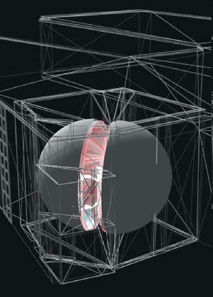
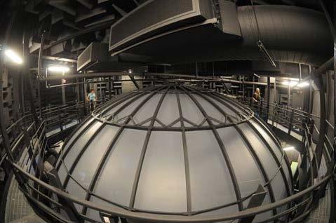
35 Virtual Reality: The Allosphere


36 Projected images


37 Augmented Reality
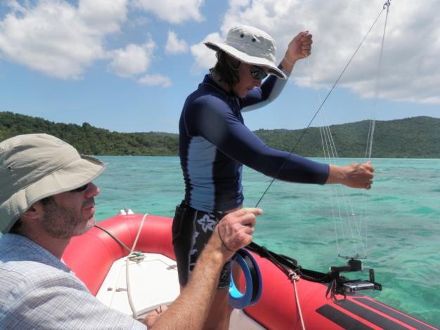
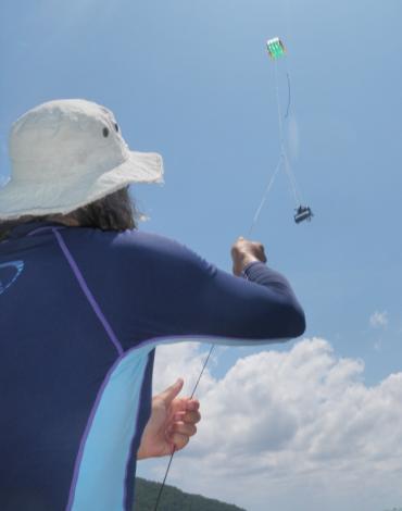
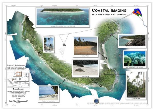
38 Kite Photogrammetry; Kitty Currier

39 Agisoft Photoscan

40 Centimeter resolution: Gigabyte files, need GPS tie points


41 Kite photogrammetry
42 How to generate images? Need many images from different angles Overlap creates stereo model Agisoft Photoscan then extracts model and assigns point cloud with color Can process with Meshlab, CloudCompare, other software Our answer: Drone (Quadcopter)

43 Phantom 4 with collision avoidance Scans height by IR sensor Position using GPS Fully gimballed camera Can be programmed to collect video or interval images 20 minutes of flight with rechargeable batteries Flight planning software, smartphone or tablet piloting

44 Mapping Ellison 1612

45 Image capture

46 Point Cloud

47 This is not a photograph

48 A 3D model from scratch


49 Closer to home
50 Summary Development of direct 3D mapping technologies LiDAR still the gold standard Both airborne and terrestrial Creates point clouds and DSMs Can map buildings and interiors, true 3D Standards and browser compatibility Many new low cost methods, kites, balloons, drones Processing via SfM software, e.g. photoscan Expect a great deal more 3D!
STARTING WITH DRONES. Data Collection and Remote Sensing with UAVs, etc. Dr. Bill Hazelton LS
 STARTING WITH DRONES Data Collection and Remote Sensing with UAVs, etc. Dr. Bill Hazelton LS What this Talk is About UAV-based data acquisition: What you need to get involved Processes in getting spatial
Assessing 3D Point Cloud Fidelity of UAS SfM Software Solutions Over Varying Terrain
 Assessing 3D Point Cloud Fidelity of UAS SfM Software Solutions Over Varying Terrain Michael Schwind, Michael J. Starek (Presenter) 18th Annual JALBTCX Airborne Coastal Mapping and Charting Technical Workshop,
Modelling. Ruth Aylett
 Modelling Ruth Aylett Overview Basic issues Modelling packages Low polygon modelling Importing models Buildings Photogrammetry Laser range finders LIDAR The great outdoors Cheap methods 3D Authoring tools
From 2D to 3D at Esri
 From 2D to 3D at Esri OGC/EuroSDR workshop on CityGML in National Mapping Paul Hardy phardy@esri.com Business Development Consultant National Mapping & Cadastre Esri 3D GIS Visualize Manage Share Analyze
Esri UC2013. Technical Workshop. Type Presentation Name Here
 Type Presentation Name Here 2013 Esri International User Conference July 8 12, 2013 San Diego, California Technical Workshop 3D Analyst An Introduction Deepinder Deol Michael Contreras Why use 3D GIS?
Introduction to photogrammetry (with an underwater flavor)
") Introduction to photogrammetry (with an underwater flavor) NAS - UCY HFF Field school, Cyprus, 2016 Dimitrios Skarlatos, Assistant Professor, Cyprus University of Technology Photogrammetric vision Lab
Introduction to photogrammetry (with an underwater flavor) NAS - UCY HFF Field school, Cyprus, 2016 Dimitrios Skarlatos, Assistant Professor, Cyprus University of Technology Photogrammetric vision Lab
Photogrammetry: DTM Extraction & Editing
 Photogrammetry: DTM Extraction & Editing How can one determine the x, y, and z of a location? Approaches to DTM Extraction Ground surveying Digitized topographic maps Traditional photogrammetry Hardcopy
3D Data Modelling at Esri. Paul Hardy Business Development Consultant Esri Europe
 3D Data Modelling at Esri Paul Hardy phardy@esri.com Business Development Consultant Esri Europe Users of 3D GIS Local government Facilities management Civil engineering 3D GIS Defense / Public Safety
Digital Elevation Models
 Digital Elevation Models National Elevation Dataset 1 Data Sets US DEM series 7.5, 30, 1 o for conterminous US 7.5, 15 for Alaska US National Elevation Data (NED) GTOPO30 Global Land One-kilometer Base
Rapid generation of 3D GIS content from reality capture data sources. Keir Keightley, HDR
 Rapid generation of 3D GIS content from reality capture data sources Keir Keightley, HDR Purpose Why do we want 3D GIS content? A picture is worth a thousand words, and more, if you can navigate it in
3D Analyst Visualization with ArcGlobe. Brady Hoak, ESRI DC
 3D Analyst Visualization with ArcGlobe Brady Hoak, ESRI DC 3D GIS Viewing geospatial data in 3D leads to new insights 2D 3D Sometimes you need to edit your data in 3D 2D 3D Some problems can only be solved
Data Integration in Building Virtual Models
 Data Integration in Building Virtual Models Erik Singels, Geospatial Information Sciences Program Brent Vollmar, Department of Geosciences Adewale Okunoren, Department of Geosciences Carlos L. V. Aiken,
Reality Modeling Drone Capture Guide
 Reality Modeling Drone Capture Guide Discover the best practices for photo acquisition-leveraging drones to create 3D reality models with ContextCapture, Bentley s reality modeling software. Learn the
Modelling. Ruth Aylett
 Modelling Ruth Aylett Overview Basic issues Modelling packages Low polygon modelling Importing models Buildings Photogrammetry Laser range finders LIDAR The great outdoors Cheap methods 3D Authoring tools
Mobile Mapping and Navigation. Brad Kohlmeyer NAVTEQ Research
 Mobile Mapping and Navigation Brad Kohlmeyer NAVTEQ Research Mobile Mapping & Navigation Markets Automotive Enterprise Internet & Wireless Mobile Devices 2 Local Knowledge & Presence Used to Create Most
Light Detection and Ranging (LiDAR)
") Light Detection and Ranging (LiDAR) http://code.google.com/creative/radiohead/ Types of aerial sensors passive active 1 Active sensors for mapping terrain Radar transmits microwaves in pulses determines
Light Detection and Ranging (LiDAR) http://code.google.com/creative/radiohead/ Types of aerial sensors passive active 1 Active sensors for mapping terrain Radar transmits microwaves in pulses determines
An Introduction to Lidar & Forestry May 2013
 An Introduction to Lidar & Forestry May 2013 Introduction to Lidar & Forestry Lidar technology Derivatives from point clouds Applied to forestry Publish & Share Futures Lidar Light Detection And Ranging
EVOLUTION OF POINT CLOUD
 Figure 1: Left and right images of a stereo pair and the disparity map (right) showing the differences of each pixel in the right and left image. (source: https://stackoverflow.com/questions/17607312/difference-between-disparity-map-and-disparity-image-in-stereo-matching)
Mayden VP of Business Development Surdex Corporation
 Making Sense of Sensors Randy Mayden, Mayden VP of Business Development Surdex Corporation randym@surdex.com EARLYAERIAL PHOTOGRAPHY 2 FIRSTAERIAL CAMERA 3 AERIAL CAMERA SYSTEM DEVELOPMENT Aerial Camera
UAV s in Surveying: Integration/processes/deliverables A-Z. 3Dsurvey.si
 UAV s in Surveying: Integration/processes/deliverables A-Z Info@eGPS.net TODAY S PROGRAM Introduction to photogrammetry and 3Dsurvey Theoretical facts about the technology and basics of 3dsurvey Introduction
Airborne Laser Survey Systems: Technology and Applications
 Abstract Airborne Laser Survey Systems: Technology and Applications Guangping HE Lambda Tech International, Inc. 2323B Blue Mound RD., Waukesha, WI-53186, USA Email: he@lambdatech.com As mapping products
Photo based Terrain Data Acquisition & 3D Modeling
 Photo based Terrain Data Acquisition & 3D Modeling June 7, 2013 Howard Hahn Kansas State University Partial funding by: KSU Office of Research and Sponsored Programs Introduction: Need Application 1 Monitoring
Trimble Geospatial Division Integrated Solutions for Geomatics professions. Volker Zirn Regional Sales Representative
 Trimble Geospatial Division Integrated Solutions for Geomatics professions Volker Zirn Regional Sales Representative 1 Agenda Trimble GeoSpatial Division Airborne System Solutions Trimble Inpho Software
GEOGRAPHIC INFORMATION SYSTEMS Lecture 25: 3D Analyst
 GEOGRAPHIC INFORMATION SYSTEMS Lecture 25: 3D Analyst 3D Analyst - 3D Analyst is an ArcGIS extension designed to work with TIN data (triangulated irregular network) - many of the tools in 3D Analyst also
Merging LiDAR Data with Softcopy Photogrammetry Data
 Merging LiDAR Data with Softcopy Photogrammetry Data Cindy McCallum WisDOT\Bureau of Technical Services Surveying & Mapping Section Photogrammetry Unit Overview Terms and processes Why use data from LiDAR
From 2D to 3D at Esri
 From 2D to 3D at Esri Paul Hardy, Esri Inc phardy@esri.com, Cambridge, UK SHORT PAPER This short paper provides an overview of the 3D capabilities of a modern GIS, illustrated by the Esri ArcGIS system,
ENY-C2005 Geoinformation in Environmental Modeling Lecture 4b: Laser scanning
 1 ENY-C2005 Geoinformation in Environmental Modeling Lecture 4b: Laser scanning Petri Rönnholm Aalto University 2 Learning objectives To recognize applications of laser scanning To understand principles
Open Pit Mines. Terrestrial LiDAR and UAV Aerial Triangulation for. Figure 1: ILRIS at work
 Terrestrial LiDAR and UAV Aerial Triangulation for Open Pit Mines Figure 1: ILRIS at work Figure 2: Geo-Copter X-8000 taking off ay what you will about the past few years, it has produced some useful tools
Automated Feature Extraction from Aerial Imagery for Forestry Projects
 Automated Feature Extraction from Aerial Imagery for Forestry Projects Esri UC 2015 UC706 Tuesday July 21 Bart Matthews - Photogrammetrist US Forest Service Southwestern Region Brad Weigle Sr. Program
Creating, managing and utilizing a 3D Virtual City in ArcGIS Tamrat Belayneh Eric Wittner
 Creating, managing and utilizing a 3D Virtual City in ArcGIS 10.1 Tamrat Belayneh (tbelayneh@esri.com) Eric Wittner (ewittner@esri.com ) Contents 3D Mapping & Ingredients of a 3D Virtual City Creating
Visualizing 2D Data in a 3D World
 Visualizing 2D Data in a 3D World Karl Kliparchuk, M.Sc., GISP, and Brendan Walashek, B.Sc. McElhanney Consulting Services Ltd. Email: kkliparchuk@mcelhanney.com and bwalashek@mcelhanney.com Agenda A Quick
Automatic reconstruction of old globes by photogrammetry and its accuracy
 Mátyás Gede Automatic reconstruction of old globes by photogrammetry and its accuracy Keywords: Globes, 3D reconstruction, photogrammetry, accuracy Summary: Virtual 3D model of an old globe can be created
PRODUCTION SYSTEM FOR AUTONOMOUS 3-DIMENSIONAL MODELING WITH LIDAR, IFSAR, AND PHOTOGRAMMETRIC DSM DATA INTRODUCTION
 PRODUCTION SYSTEM FOR AUTONOMOUS 3-DIMENSIONAL MODELING WITH LIDAR, IFSAR, AND PHOTOGRAMMETRIC DSM DATA Mark Rahmes, Software Engineer Josef DeVaughn Allen, Software Engineer J. Harlan Yates, System Engineer
Light Detection and Ranging (LiDAR) Radiohead House of Cards
 Radiohead House of Cards") Light Detection and Ranging (LiDAR) Radiohead House of Cards http://the-moni-blog.blogspot.com/2009/03/lidar-is-going-mainstream-mtv-baby.html h =? Laser Vision GPS + IMU θ H X a h Types of aerial sensors
Light Detection and Ranging (LiDAR) Radiohead House of Cards http://the-moni-blog.blogspot.com/2009/03/lidar-is-going-mainstream-mtv-baby.html h =? Laser Vision GPS + IMU θ H X a h Types of aerial sensors
a Geo-Odyssey of UAS LiDAR Mapping Henno Morkel UAS Segment Specialist DroneCon 17 May 2018
 a Geo-Odyssey of UAS LiDAR Mapping Henno Morkel UAS Segment Specialist DroneCon 17 May 2018 Abbreviations UAS Unmanned Aerial Systems LiDAR Light Detection and Ranging UAV Unmanned Aerial Vehicle RTK Real-time
A step by step introduction to TopoFlight
 November 20, 2014 TopoFlight_First_Steps.docx 2004057./KB/04 A step by step introduction to TopoFlight Content 1 Introduction...2 2 Creating the area of interest with GoogleEarth...2 3 Creating the TopoFlight
Proposal of data source and method for creating 3D models of buildings
 The 9 th International Conference ENVIRONMENTAL ENGINEERING 22 23 May 2014, Vilnius, Lithuania SELECTED PAPERS eissn 2029-7092 / eisbn 978-609-457-640-9 Available online at http://enviro.vgtu.lt Section:
UAS for Surveyors. An emerging technology for the Geospatial Industry. Ian Murgatroyd : Technical Sales Rep. Trimble
 UAS for Surveyors An emerging technology for the Geospatial Industry Ian Murgatroyd : Technical Sales Rep. Trimble Project Overview Voyager Quarry, located near Perth Australia Typical of hard rock mines,
THREE DIMENSIONAL CURVE HALL RECONSTRUCTION USING SEMI-AUTOMATIC UAV
 THREE DIMENSIONAL CURVE HALL RECONSTRUCTION USING SEMI-AUTOMATIC UAV Muhammad Norazam Zulgafli 1 and Khairul Nizam Tahar 1,2 1 Centre of Studies for Surveying Science and Geomatics, Faculty of Architecture
Trimble GeoSpatial Products
 Expanding Solutions for Photogrammetric and Remote Sensing Professionals 55 th Photogrammetric Week in Stuttgart September 7 th 2015 Tobias Heuchel, Trimble Stuttgart, Germany Trimble GeoSpatial Products
Overview. Modelling. 3D Authoring tools. Other VR Software Tools. 3D Modelling Tools. 3D Studio Max. Ruth Aylett
 Modelling Ruth Aylett Overview Basic issues Modelling packages Low polygon modelling Importing models City modelling Photogrammetry Laser range finders LIDAR The great outdoors Trees, plants, water etc
Structure from Motion: High resolution DEMs at any scale using everyday equipment
 Structure from Motion: High resolution DEMs at any scale using everyday equipment Anders Damsgaard Last revision: May 20, 2014 Outline Photogrammetry Method Examples Summary Photogrammetry using SfM Production
Modelling. Ruth Aylett
 Modelling Ruth Aylett Overview Basic issues Modelling packages Low polygon modelling Importing models City modelling Photogrammetry Laser range finders LIDAR The great outdoors Trees, plants, water etc
2/19/2018. Who are we? Who am I? What is Scanning? How does scanning work? How does scanning work? Scanning for Today s Surveyors
 2/19/2018 Who are we? Scanning for Today s Surveyors Survey, GIS, and Construction dealer Founded in 1988 Employee Owned Headquartered in Bismarck, ND States covered: ND, SD, MN, MT, WY, CO, UT, ID, WA,
Assimilation of Break line and LiDAR Data within ESRI s Terrain Data Structure (TDS) for creating a Multi-Resolution Terrain Model
 for creating a Multi-Resolution Terrain Model") Assimilation of Break line and LiDAR Data within ESRI s Terrain Data Structure (TDS) for creating a Multi-Resolution Terrain Model Tarig A. Ali Department of Civil Engineering American University of Sharjah,
Assimilation of Break line and LiDAR Data within ESRI s Terrain Data Structure (TDS) for creating a Multi-Resolution Terrain Model Tarig A. Ali Department of Civil Engineering American University of Sharjah,
Surface Analysis with 3D Analyst
 2013 Esri International User Conference July 8 12, 2013 San Diego, California Technical Workshop Surface Analysis with 3D Analyst Khalid H. Duri Esri UC2013. Technical Workshop. Why use 3D GIS? Because
Experiments on Generation of 3D Virtual Geographic Environment Based on Laser Scanning Technique
 Experiments on Generation of 3D Virtual Geographic Environment Based on Laser Scanning Technique Jie Du 1, Fumio Yamazaki 2 Xiaoyong Chen 3 Apisit Eiumnoh 4, Michiro Kusanagi 3, R.P. Shrestha 4 1 School
Over the years, they have been used several tools to perform aerial surveys of analyzed to archaeological sites and monuments. From the plane to the
 Over the years, they have been used several tools to perform aerial surveys of analyzed to archaeological sites and monuments. From the plane to the balloon, the balloon to the telescopic rods, all of
VALIDATION OF A NEW 30 METER GROUND SAMPLED GLOBAL DEM USING ICESAT LIDARA ELEVATION REFERENCE DATA
 VALIDATION OF A NEW 30 METER GROUND SAMPLED GLOBAL DEM USING ICESAT LIDARA ELEVATION REFERENCE DATA M. Lorraine Tighe Director, Geospatial Solutions Intermap Session: Photogrammetry & Image Processing
Aerial and Mobile LiDAR Data Fusion
 Creating Value Delivering Solutions Aerial and Mobile LiDAR Data Fusion Dr. Srini Dharmapuri, CP, PMP What You Will Learn About LiDAR Fusion Mobile and Aerial LiDAR Technology Components & Parameters Project
Geospatial, 3D, Visualization and BIM Convergence at the intersection
 Geospatial, 3D, Visualization and BIM Convergence at the intersection Fred Limp Leica Geosystems Chair University Professor and Director Center for Advanced Spatial Technologies University of Arkansas,
Available online at ScienceDirect. Procedia Environmental Sciences 36 (2016 )
") Available online at www.sciencedirect.com ScienceDirect Procedia Environmental Sciences 36 (2016 ) 184 190 International Conference on Geographies of Health and Living in Cities: Making Cities Healthy
Available online at www.sciencedirect.com ScienceDirect Procedia Environmental Sciences 36 (2016 ) 184 190 International Conference on Geographies of Health and Living in Cities: Making Cities Healthy
USE OF DRONE TECHNOLOGY AND PHOTOGRAMMETRY FOR BEACH MORPHODYNAMICS AND BREAKWATER MONITORING.
 Proceedings of the 6 th International Conference on the Application of Physical Modelling in Coastal and Port Engineering and Science (Coastlab16) Ottawa, Canada, May 10-13, 2016 Copyright : Creative Commons
Microwave. Infrared. Preprogrammed Chip
 Advanced Technology for Design Mapping and Construction Layout AACE A.A.C.E. Meeting August 5, 2009 Daniel K. Mardock RBF Consulting Survey Manager Registered Land Surveyor Certified Federal Surveyor Arizona
UAV Flight Operations for Mapping. Precision. Accuracy. Reliability
 UAV Flight Operations for Mapping Precision. Accuracy. Reliability Part One: Why is Mapping different? Part Two: What about accuracy and precision? Part Three: What is the Workflow? Part Four: AGENDA What
Terrestrial GPS setup Fundamentals of Airborne LiDAR Systems, Collection and Calibration. JAMIE YOUNG Senior Manager LiDAR Solutions
 Terrestrial GPS setup Fundamentals of Airborne LiDAR Systems, Collection and Calibration JAMIE YOUNG Senior Manager LiDAR Solutions Topics Terrestrial GPS reference Planning and Collection Considerations
High Definition Modeling of Calw, Badstrasse and its Google Earth Integration
 Master Thesis Yuanting LI High Definition Modeling of Calw, Badstrasse and its Google Earth Integration Duration of the Thesis: 6 months Completion: July, 2014 Supervisors: Prof.Dr.-Ing.Dieter Fritsch
CE 59700: LASER SCANNING
 Digital Photogrammetry Research Group Lyles School of Civil Engineering Purdue University, USA Webpage: http://purdue.edu/ce/ Email: ahabib@purdue.edu CE 59700: LASER SCANNING 1 Contact Information Instructor:
Contents of Lecture. Surface (Terrain) Data Models. Terrain Surface Representation. Sampling in Surface Model DEM
 Data Models. Terrain Surface Representation. Sampling in Surface Model DEM") Lecture 13: Advanced Data Models: Terrain mapping and Analysis Contents of Lecture Surface Data Models DEM GRID Model TIN Model Visibility Analysis Geography 373 Spring, 2006 Changjoo Kim 11/29/2006 1
Lecture 13: Advanced Data Models: Terrain mapping and Analysis Contents of Lecture Surface Data Models DEM GRID Model TIN Model Visibility Analysis Geography 373 Spring, 2006 Changjoo Kim 11/29/2006 1
Overview of the Trimble TX5 Laser Scanner
 Overview of the Trimble TX5 Laser Scanner Trimble TX5 Revolutionary and versatile scanning solution Compact / Lightweight Efficient Economical Ease of Use Small and Compact Smallest and most compact 3D
TcpMDT. Digital Terrain Model Version 7.5. TcpMDT
 Digital Terrain Model Version 7.5 Versions and Modules PROFESSIONAL STANDARD IMAGES SURVEYING POINT CLOUD Product Features STANDARD Surveying Points Management Digital Terrain Model Contours Terrain Cross
XXV FIG International Congress KUALA LUMPUR Highly Detailed 3D Modelling of Mayan Cultural Heritage using an UAV
 XXV FIG International Congress KUALA LUMPUR 2014 Highly Detailed 3D Modelling of Mayan Cultural Heritage using an UAV Cornelis Stal, Britt Lonneville, Timothy Nuttens, Philippe De Maeyer, Alain De Wulf
Drone2Map: an Introduction. October 2017
 Drone2Map: an Introduction October 2017 Drone2Map: An Introduction Topics: - Introduction to Drone Mapping - Coordinate Systems - Overview of Drone2Map - Basic Drone2Map Workflow - 2D Data Processing -
Drones for research - Observing the world in 3D from a LiDAR-UAV
 Drones for research - Observing the world in 3D from a LiDAR-UAV Program lunch seminar: Lammert Kooistra: The Unmanned Aerial Remote Sensing Facility goes 3D: Unmanned Aerial Laser Scanning Sander Mücher:
GIS Data Collection. This chapter reviews the main methods of GIS data capture and transfer and introduces key practical management issues.
 9 GIS Data Collection OVERVIEW This chapter reviews the main methods of GIS data capture and transfer and introduces key practical management issues. It distinguishes between primary (direct measurement)
An Introduction to Geometric Modeling using Polygonal Meshes
 An Introduction to Geometric Modeling using Polygonal Meshes Joaquim Madeira Version 0.2 October 2014 U. Aveiro, October 2014 1 Main topics CG and affine areas Geometric Modeling Polygonal meshes Exact
REMOTE SENSING LiDAR & PHOTOGRAMMETRY 19 May 2017
 REMOTE SENSING LiDAR & PHOTOGRAMMETRY 19 May 2017 SERVICES Visual Inspections Digital Terrain Models Aerial Imagery Volume Computations Thermal Inspections Photo maps Aerial Video Training & Consultancy
Overview. 1. Aerial LiDAR in Wisconsin (20 minutes) 2. Demonstration of data in CAD (30 minutes) 3. High Density LiDAR (20 minutes)
 2. Demonstration of data in CAD (30 minutes) 3. High Density LiDAR (20 minutes)") Overview 1. Aerial LiDAR in Wisconsin (20 minutes) 2. Demonstration of data in CAD (30 minutes) 3. High Density LiDAR (20 minutes) 4. Aerial lidar technology advancements (15 minutes) 5. Q & A 1. Aerial
Overview 1. Aerial LiDAR in Wisconsin (20 minutes) 2. Demonstration of data in CAD (30 minutes) 3. High Density LiDAR (20 minutes) 4. Aerial lidar technology advancements (15 minutes) 5. Q & A 1. Aerial
N.J.P.L.S. An Introduction to LiDAR Concepts and Applications
 N.J.P.L.S. An Introduction to LiDAR Concepts and Applications Presentation Outline LIDAR Data Capture Advantages of Lidar Technology Basics Intensity and Multiple Returns Lidar Accuracy Airborne Laser
Airborne Sensor Technology
 Airborne Sensor Technology Arthur Rohrbach Airborne Sensor Manager EMEA Geospatial Solutions Division (GSD) 1 The World of Airborne Sensor Technology 2 Agenda Hexagon Geosystems Leica & Z/I airborne solutions
Outline of Presentation. Introduction to Overwatch Geospatial Software Feature Analyst and LIDAR Analyst Software
 Outline of Presentation Automated Feature Extraction from Terrestrial and Airborne LIDAR Presented By: Stuart Blundell Overwatch Geospatial - VLS Ops Co-Author: David W. Opitz Overwatch Geospatial - VLS
Using Databases for 3D Data Management From Point Cloud to City Model
 Using Databases for 3D Data Management From Point Cloud to City Model Hans Viehmann 1 1 ORACLE Corporation, Server Technologies Division, Hamburg, Germany, hans.viehmann@oracle.com Abstract With the cost
Mapping Project Report Table of Contents
 LiDAR Estimation of Forest Leaf Structure, Terrain, and Hydrophysiology Airborne Mapping Project Report Principal Investigator: Katherine Windfeldt University of Minnesota-Twin cities 115 Green Hall 1530
Hand-on introduction to 3D Digitisation Stephen Gray & Kirsty Merrett UoB Research Data Service
 Hand-on introduction to 3D Digitisation Stephen Gray & Kirsty Merrett UoB Research Data Service Plan Some basic information Laser scanning practical (in this room) Structured light scanning practical (in
Active Stereo Vision. COMP 4900D Winter 2012 Gerhard Roth
 Active Stereo Vision COMP 4900D Winter 2012 Gerhard Roth Why active sensors? Project our own texture using light (usually laser) This simplifies correspondence problem (much easier) Pluses Can handle different
Digital Elevation Models (DEMs)
") Digital Elevation Models (DEM) - Terrain Models (DTM) How has relief depiction on maps and online changed with digital mapping/ GIS?.. Perhaps more than the other map elements / layers Digital Elevation
Digital Elevation Models (DEM) - Terrain Models (DTM) How has relief depiction on maps and online changed with digital mapping/ GIS?.. Perhaps more than the other map elements / layers Digital Elevation
TCP MDT Digital Terrain Model - V7.5
 TCP MDT Digital Terrain Model - V7.5 Standard Version Introduction The Standard Version is suitable for carrying out all kinds of topographical survey projects, terrain profiles, volume calculations etc.
Lecture 11. LiDAR, RADAR
 NRMT 2270, Photogrammetry/Remote Sensing Lecture 11 Calculating the Number of Photos and Flight Lines in a Photo Project LiDAR, RADAR Tomislav Sapic GIS Technologist Faculty of Natural Resources Management
Bonemapping: A LiDAR Processing and Visualization Approach and Its Applications
 Bonemapping: A LiDAR Processing and Visualization Approach and Its Applications Thomas J. Pingel Northern Illinois University National Geography Awareness Week Lecture Department of Geology and Geography
Sasanka Madawalagama Geoinformatics Center Asian Institute of Technology Thailand
 Sasanka Madawalagama Geoinformatics Center Asian Institute of Technology Thailand This learning material was not prepared by ADB. The views expressed in this document are the views of the author/s and
UAV Surveying II. Precision. Accuracy. Reliability
 UAV Surveying II Precision. Accuracy. Reliability Part One: Project Lifecycle Deliverables Part Two: Evaluation of UAV Data Accuracy and Examples of Error Part Three: AGENDA Review of Results Examples
Iowa Department of Transportation Office of Design. Photogrammetric Mapping Specifications
 Iowa Department of Transportation Office of Design Photogrammetric Mapping Specifications March 2015 1 Purpose of Manual These Specifications for Photogrammetric Mapping define the standards and general
Managing Lidar and Photogrammetric Point Clouds. Lindsay Weitz Cody Benkelman
 and Photogrammetric Point Clouds Lindsay Weitz Cody Benkelman Presentation Context What is lidar, and how does it work? Not this presentation! What can you do with lidar in ArcGIS? What does Esri recommend
AIRBORNE GEIGER MODE LIDAR - LATEST ADVANCEMENTS IN REMOTE SENSING APPLICATIONS RANDY RHOADS
 Place image here (10 x 3.5 ) AIRBORNE GEIGER MODE LIDAR - LATEST ADVANCEMENTS IN REMOTE SENSING APPLICATIONS RANDY RHOADS Geospatial Industry Manager HARRIS.COM #HARRISCORP Harris Company Information SECURITY
The Processing of Laser Scan Data for the Analysis of Historic Structures in Ireland
 The 7th International Symposium on Virtual Reality, Archaeology and Cultural Heritage VAST (2006) M. Ioannides, D. Arnold, F. Niccolucci, K. Mania (Editors) The Processing of Laser Scan Data for the Analysis
Digital Defence LiDAR based Smart 3D Geospatial Intelligence for Smart Defence
 www. geokno.com Digital Defence LiDAR based Smart 3D Geospatial Intelligence for Smart Defence Presentation Agenda About Geokno About LiDAR Technology LiDAR Products for Security Forces Development uses
LiForest Software White paper. TRGS, 3070 M St., Merced, 93610, Phone , LiForest
 0 LiForest LiForest is a platform to manipulate large LiDAR point clouds and extract useful information specifically for forest applications. It integrates a variety of advanced LiDAR processing algorithms
InSAR DEM; why it is better?
 InSAR DEM; why it is better? What is a DEM? Digital Elevation Model (DEM) refers to the process of demonstrating terrain elevation characteristics in 3-D space, but very often it specifically means the
TcpMDT Version 7.0 Summary of Differences with Version 6.5
 Sumatra, 9 E-29190 Málaga (Spain) www.aplitop.com Tel.: +34 95 2439771 Fax: +34 95 2431371 TcpMDT Version 7.0 Summary of Differences with Version 6.5 CAD Versions supported TcpMDT 7 works with several
HEURISTIC FILTERING AND 3D FEATURE EXTRACTION FROM LIDAR DATA
 HEURISTIC FILTERING AND 3D FEATURE EXTRACTION FROM LIDAR DATA Abdullatif Alharthy, James Bethel School of Civil Engineering, Purdue University, 1284 Civil Engineering Building, West Lafayette, IN 47907
From Multi-sensor Data to 3D Reconstruction of Earth Surface: Innovative, Powerful Methods for Geoscience and Other Applications
 From Multi-sensor Data to 3D Reconstruction of Earth Surface: Innovative, Powerful Methods for Geoscience and Other Applications Bea Csatho, Toni Schenk*, Taehun Yoon* and Michael Sheridan, Department
DIGITAL PHOTOGRAMMETRY, DEVELOPMENTS AT ORDNANCE SURVEY
 DIGITAL PHOTOGRAMMETRY, DEVELOPMENTS AT ORDNANCE SURVEY Lynne ALLAN *, David HOLLAND ** Ordnance Survey, Southampton, GB * lallan@ordsvy.gov.uk ** dholland@ordsvy.gov.uk KEY WORDS: Photogrammetry, Digital,
Lidar Sensors, Today & Tomorrow. Christian Sevcik RIEGL Laser Measurement Systems
 Lidar Sensors, Today & Tomorrow Christian Sevcik RIEGL Laser Measurement Systems o o o o Online Waveform technology Stand alone operation no field computer required Remote control through wireless network
HawkEye III - A new deep penetrating bathymetric LIDAR system
 Please insert a picture (Insert, Picture, from file). Size according to grey field (10 cm x 25.4 cm). Scale picture: highlight, pull corner point Cut picture: highlight, choose the cutting icon from the
Bringing Singapore to life in 3D
 Bringing Singapore to life in 3D Dr Victor Khoo, Deputy Director Singapore Land Authority Bringing Singapore to life in 3D ESRI Singapore UC 2016 Dr. Victor Khoo Singapore Land Authority SLA 2016 RESTRICTED
The raycloud A Vision Beyond the Point Cloud
 The raycloud A Vision Beyond the Point Cloud Christoph STRECHA, Switzerland Key words: Photogrammetry, Aerial triangulation, Multi-view stereo, 3D vectorisation, Bundle Block Adjustment SUMMARY Measuring
DEVELOPMENT OF ORIENTATION AND DEM/ORTHOIMAGE GENERATION PROGRAM FOR ALOS PRISM
 DEVELOPMENT OF ORIENTATION AND DEM/ORTHOIMAGE GENERATION PROGRAM FOR ALOS PRISM Izumi KAMIYA Geographical Survey Institute 1, Kitasato, Tsukuba 305-0811 Japan Tel: (81)-29-864-5944 Fax: (81)-29-864-2655
Lecture 4: Digital Elevation Models
 Lecture 4: Digital Elevation Models GEOG413/613 Dr. Anthony Jjumba 1 Digital Terrain Modeling Terms: DEM, DTM, DTEM, DSM, DHM not synonyms. The concepts they illustrate are different Digital Terrain Modeling
SimActive and PhaseOne Workflow case study. By François Riendeau and Dr. Yuri Raizman Revision 1.0
 SimActive and PhaseOne Workflow case study By François Riendeau and Dr. Yuri Raizman Revision 1.0 Contents 1. Introduction... 2 1.1. Simactive... 2 1.2. PhaseOne Industrial... 2 2. Testing Procedure...
Todd King, PLS, LEED AP Business Developer
 Todd King, PLS, LEED AP Business Developer TKing@McKimCreed.com 38 YEARS 378 EMPLOYEES ENR Top 500 Design Firm ENR Top 200 Environmental ENR Southeast Engineer Firms POB Geospatial Top 100 Top 50 Trenchless